Mississippian strata of southeastern New Mexico: distribution, structure, and hydrocarbon plays
advertisement
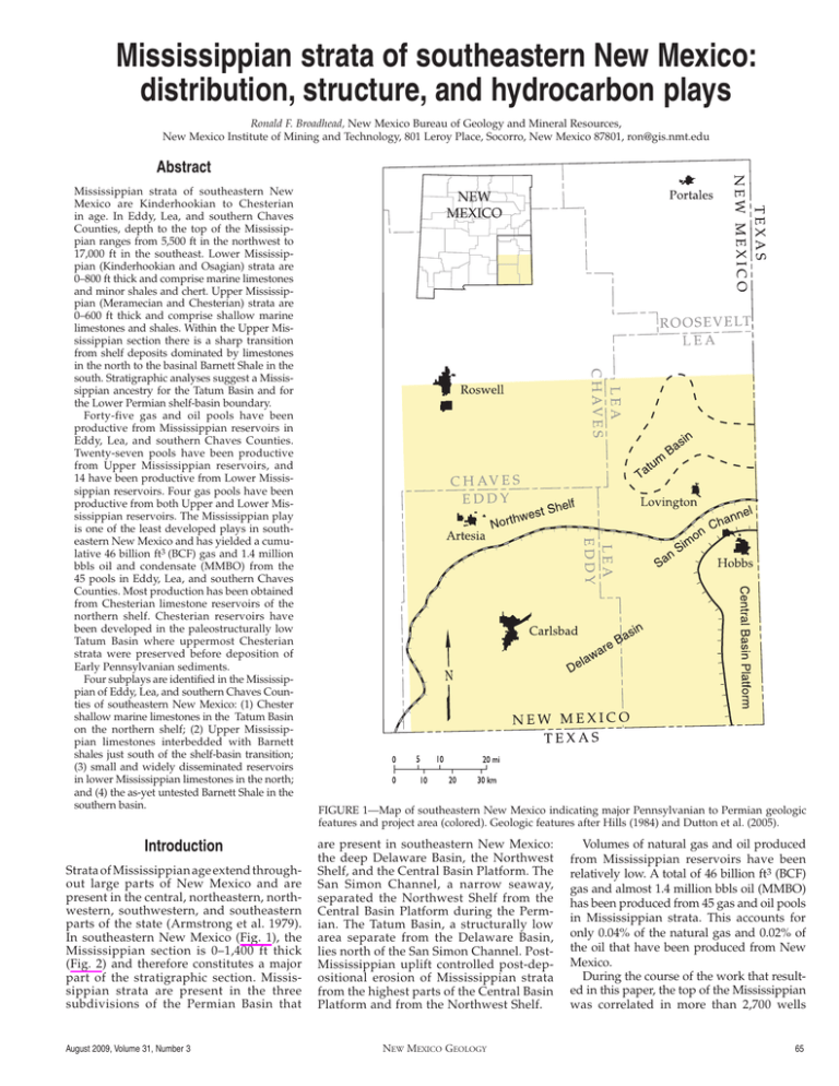
Mississippian strata of southeastern New Mexico: distribution, structure, and hydrocarbon plays Ronald F. Broadhead, New Mexico Bureau of Geology and Mineral Resources, New Mexico Institute of Mining and Technology, 801 Leroy Place, Socorro, New Mexico 87801, ron@gis.nmt.edu Abstract Mississippian strata of southeastern New Mexico are Kinderhookian to Chesterian in age. In Eddy, Lea, and southern Chaves Counties, depth to the top of the Mississippian ranges from 5,500 ft in the northwest to 17,000 ft in the southeast. Lower Mississippian (Kinderhookian and Osagian) strata are 0–800 ft thick and comprise marine limestones and minor shales and chert. Upper Mississippian (Meramecian and Chesterian) strata are 0–600 ft thick and comprise shallow marine limestones and shales. Within the Upper Mississippian section there is a sharp transition from shelf deposits dominated by limestones in the north to the basinal Barnett Shale in the south. Stratigraphic analyses suggest a Mississippian ancestry for the Tatum Basin and for the Lower Permian shelf-basin boundary. Forty-five gas and oil pools have been productive from Mississippian reservoirs in Eddy, Lea, and southern Chaves Counties. Twenty-seven pools have been productive from Upper Mississippian reservoirs, and 14 have been productive from Lower Mississippian reservoirs. Four gas pools have been productive from both Upper and Lower Mississippian reservoirs. The Mississippian play is one of the least developed plays in southeastern New Mexico and has yielded a cumulative 46 billion ft3 (BCF) gas and 1.4 million bbls oil and condensate (MMBO) from the 45 pools in Eddy, Lea, and southern Chaves Counties. Most production has been obtained from Chesterian limestone reservoirs of the northern shelf. Chesterian reservoirs have been developed in the paleostructurally low Tatum Basin where uppermost Chesterian strata were preserved before deposition of Early Pennsylvanian sediments. Four subplays are identified in the Mississippian of Eddy, Lea, and southern Chaves Counties of southeastern New Mexico: (1) Chester shallow marine limestones in the Tatum Basin on the northern shelf; (2) Upper Mississippian limestones interbedded with Barnett shales just south of the shelf-basin transition; (3) small and widely disseminated reservoirs in lower Mississippian limestones in the north; and (4) the as-yet untested Barnett Shale in the southern basin. Introduction Strata of Mississippian age extend throughout large parts of New Mexico and are present in the central, northeastern, northwestern, southwestern, and southeastern parts of the state (Armstrong et al. 1979). In southeastern New Mexico (Fig. 1), the Mississippian section is 0–1,400 ft thick (Fig. 2) and therefore constitutes a major part of the stratigraphic section. Mississippian strata are present in the three subdivisions of the Permian Basin that August 2009, Volume 31, Number 3 Figure 1—Map of southeastern New Mexico indicating major Pennsylvanian to Permian geologic features and project area (colored). Geologic features after Hills (1984) and Dutton et al. (2005). are present in southeastern New Mexico: the deep Delaware Basin, the Northwest Shelf, and the Central Basin Platform. The San Simon Channel, a narrow seaway, separated the Northwest Shelf from the Central Basin Platform during the Permian. The Tatum Basin, a structurally low area separate from the Delaware Basin, lies north of the San Simon Channel. PostMississippian uplift controlled post-depositional erosion of Mississippian strata from the highest parts of the Central Basin Platform and from the Northwest Shelf. New Mexico Geology Volumes of natural gas and oil produced from Mississippian reservoirs have been relatively low. A total of 46 billion ft3 (BCF) gas and almost 1.4 million bbls oil (MMBO) has been produced from 45 gas and oil pools in Mississippian strata. This accounts for only 0.04% of the natural gas and 0.02% of the oil that have been produced from New Mexico. During the course of the work that resulted in this paper, the top of the Mississippian was correlated in more than 2,700 wells 65 Figure 2—Isopach map of Mississippian strata in southeastern New Mexico. (Fig. 3). The various maps presented in this paper were contoured digitally with Surfer 8 (Surfer 8 is a registered trademark of Golden Software, Inc.) using a kriging algorithm from the information obtained by correlating the wells. Additional work, databases of well information, detailed cross sections that include well logs, and more detailed maps are presented in Broadhead (2006) and Broadhead and Gillard (2007). Reservoirs were assigned to stratigraphic units based upon correlations performed for this study. Production data were obtained from the New Mexico Oil Conservation Division, and cumulative production was calculated using methodology detailed in Dutton et al. (2005) and Broadhead et al. (2004). Stratigraphy The Mississippian System in southeastern New Mexico is 0–1,400 ft thick. For this project, the Mississippian was subdivided into two stratigraphic units, the Upper Mississippian and the lower Mississippian limestone (Fig. 4). These subdivisions generally reflect common usage and simplify the published stratigraphy of local studies (e.g., Hamilton and Asquith 2000) in order to accommodate regional correlations. By the time the Upper Mississippian was deposited, the Mississippian basin had become differentiated into a northern shelf area and a 66 southern basinal area. Upper Mississippian stratigraphy reflects this paleobathymetric differentiation. To the south in the basin, the Upper Mississippian is dominated by black to gray marine shales of the Barnett Shale (Figs. 5, 6). To the north on the shelf, the Upper Mississippian is dominated by shelfal carbonate strata and can be subdivided vertically into a lower Meramec unit and an upper Chester unit (Figs. 5, 7). Tongues of basinal shale extend northward onto the shelf where they are intercalated with the shallow-water Meramec and Chester carbonates. Mississippian strata are truncated in a westward direction by a regional angular unconformity at the base of the Pennsylvanian (Fig. 7). The lower Mississippian limestone is 0–800 ft thick in southeastern New Mexico (Fig. 8). All but the lowermost 20–50 ft are considered to be Osagian in age; the lowermost 20–50 ft are thought to be Kinderhookian in age (Broadhead 2006). Lower Mississippian strata are thickest in the Tatum Basin north of the Central Basin Platform. They thin to the west and southwest and are absent from the Central Basin Platform where they were uplifted and eroded during the Pennsylvanian. They pinch out to the northwest underneath the overlying Pennsylvanian System. The presence of an area of maximum thickness in the Tatum Basin, where the New Mexico Geology lower Mississippian limestone is overlain by the Upper Mississippian, suggests this tectonic feature may have been present as a structurally low area as far back as Early Mississippian time. Few published reports describe the Lower Mississippian section in the subsurface of southeastern New Mexico. In northern Lea County, Hamilton and Asquith (2000) described the upper part of the Osagian section as composed of brown to tan lime mudstones with minor sponge spicules and brachiopod spines in a lime mud matrix. Sample logs of well cuttings indicate the Osagian section is composed of tan to darkbrown, finely crystalline, dense limestone, and preliminary observations indicate that lime mudstones are the dominant carbonate lithology. Siliciclastic shales are prevalent in areas. The limestones are darker to the west and southwest, coinciding with a general thinning of the Lower Mississippian section in those directions (Fig. 8). Gray to dark-brown chert is also indicated on the sample logs. The percentage of chert generally appears to increase toward the west and southwest. Upper Mississippian strata vary in thickness from 0 ft to more than 600 ft (Fig. 9). The Upper Mississippian section is Meramecian and Chesterian in age (Fig. 4). The Upper Mississippian has been described more fully in the literature than the Lower Mississippian because of the reservoir study by Hamilton and Asquith (2000) in northern Lea County. The Chester and Meramec consist mostly of limestones with some interbedded shales. There is a facies transition from a shelfal limestone-dominated facies in the north to the basinal shale facies (Barnett Shale) in the south (Hamilton and Asquith 2000; Broadhead and Gillard 2007). Tongues of Barnett Shale extend northward onto the shelf where they interfinger with shelf limestones, and thin tongues of limestone extend southward into the basin and pinch out a few miles south of the Barnett Shale boundary indicated in Fig. 9. Traditional correlations have included a lower shale-dominated facies of the Morrow in the Barnett, but this research places that shale in the lower part of the Morrow (Broadhead and Gillard 2007; Fig. 4). At the Austin Mississippian gas pool of northern Lea County, Hamilton and Asquith (2000) described the upper Chester as dominated by bioclastic oolitic grainstones and bioclastic oolitic packstones. In addition to oolites, the grainstones contain fragments of bryozoans, crinoids, trilobites, and brachiopods. Where not completely cemented by calcite, porosity is present, and this facies forms reservoirs (Hamilton and Asquith 2000). The productive oolitic zones trend northeast-southwest in the Austin pool. The bioclastic oolitic packstones contain fragments of bryozoans, crinoids, trilobites, brachiopods, as well as oolites. In this facies, intergranular areas are filled with lime mud, so porosity is minimal; this facies does not form reservoirs (Hamilton and Asquith 2000). August 2009, Volume 31, Number 3 August 2009, Volume 31, Number 3 New Mexico Geology 67 Figure 3—Locations of wells used to correlate Mississippian strata and construct the isopach and structure maps presented in this paper and locations of cross sections A–A’ (Fig. 5), B–B’ (Fig. 7), and C–C’ (Fig. 6). Figure 4—Stratigraphic chart of Mississippian rocks in southeastern and south-central New Mexico. From Broadhead and Gillard (2007). Stratigraphy of Mississippian rocks in outcrops of the Sacramento Mountains of south-central New Mexico included for reference. Figure 5—North-south stratigraphic cross section A–A’ of Mississippian strata extending from shelfal strata in the north to basinal strata in the south. Datum is top of Mississippian System. See Figure 3 for location. 68 New Mexico Geology August 2009, Volume 31, Number 3 Figure 6—East-west stratigraphic cross section C–C’ of Mississippian strata in the southern part of the project area showing truncation of Mississippian strata underneath regional angular unconformity at the base of the Pennsylvanian. Datum is top of Mississippian System. See Figure 3 for location. Figure 7—East-west stratigraphic cross section B–B’ of Mississippian strata in the northern part of the project area showing truncation of Mississippian strata underneath regional angular unconformity at the base of the Pennsylvanian. Datum is top of Mississippian System. See Figure 3 for location. Underlying Hamilton and Asquith’s upper Chester unit are their lower Chester and Meramec units and intercalated tongues of the Barnett Shale. The limestones in these units are bioclastic grainstones and bioclastic packstones (Hamilton and Asquith 2000). The bioclastic grainstones consist of fragments of bryozoans, crinoids, trilobites, and brachiopods. No oolites are present. Pore spaces have been completely filled by calcite cements, so the grainstones in the Meramec and lower Chester do not form reservoirs. The bioclastic packstones consist of fragments of bryozoans, crinoids, trilobites, and brachiopods. No oolites are present. Intergranular areas are filled with lime mud, so porosity is minimal; the packstones do not form reservoirs. Intercalated August 2009, Volume 31, Number 3 Barnett tongues are described by Hamilton and Asquith as black marine shales. The Barnett Shale is 200–400 ft thick in southeastern New Mexico (Fig. 9). The Barnett consists of dark-gray to black marine shales and minor sandstones and limestones. As mentioned above, a significant section of shale considered to be Lower Pennsylvanian overlies the Barnett but has traditionally been considered to be Barnett; this Lower Pennsylvanian shale attains a maximum thickness of 1,000 ft in southeastern Lea County (Broadhead and Gillard 2007). Structure Depth to top of the Mississippian ranges from 5,500 ft in T14S R24E in the northwestern New Mexico Geology part of the project area to more than 17,000 ft in the southeastern part of the project area. In the northwest, stratigraphic correlations indicate the Upper Mississippian was removed by pre-Pennsylvanian erosion, and the upper surface of the Mississippian System is formed by Lower Mississippian strata in this area. The structure-contour map of the top of the Mississippian (Fig. 10) clearly indicates the major tectonic features in the region: the deep Delaware Basin, the Northwest Shelf, the Central Basin Platform, the Tatum Basin, and the Huapache monocline. The southeastward dip into the Delaware Basin from the Northwest Shelf dominates the structure in the northern and central parts of the maps. The structure map does not indicate a sharp boundary between the Northwest Shelf and the Delaware Basin, which is largely a depositional phenomenon that was caused in part by local upward growth of Pennsylvanian and Lower Permian (Abo) shelf-margin carbonate complexes over paleostructures. However, the eastern half of the Barnett zero isopach line is largely coincident with the trend of Abo shelf-margin carbonate reservoirs (Fig. 11), suggesting that the shelfto-basin transition may have been localized on a low-relief Late Mississippian structural flexure that later influenced position of the Early Permian shelf margin. Alternatively, greater compaction of the Barnett shales deposited south of the transition compared to the limestone-dominated Upper Mississippian shelf section to the north may have led to localization of carbonate buildups at the Abo shelf margin. The Huapache monocline is clearly delineated by structure contours in the southwest part of the structure map (Fig. 10). Although this structure is defined by a reverse fault zone at the Mississippian level (see Casavant 1999), the computer-generated contour map depicts the fault zone as closely spaced contours. The Central Basin Platform, formed by high-angle faults (Hills 1984; Haigler and Cunningham 1972), is also clearly defined by the structure-contour map on top of the Mississippian System. The closely spaced contours define the fault zones that bound this uplifted tectonic block. On higher parts of the Central Basin Platform, Mississippian strata were removed by erosion during Pennsylvanian time; therefore, no structure contours are present in these areas. The Tatum Basin, the structurally low area north of the Central Basin Platform, is clearly depicted on the structure-contour map. As discussed previously, Lower Mississippian strata are thicker in the Tatum Basin than in adjacent areas. This suggests that structural development of this low feature may have occurred as far back as Early Mississippian time. Many smaller structures are superimposed over the major tectonic features of the region. These smaller structures generally cover areas 1 mi2 (one section) to 36 mi2 (one township). These smaller structures are depicted on the 69 Figure 8—Isopach map of Lower Mississippian strata in southeastern New Mexico. structure-contour map as enclosed structurally high areas or as southeast-dipping structural noses superimposed on the regional slope that defines the transition between the Northwest Shelf and the Delaware Basin. These structures have a relief of 50–500 ft. In general, Upper Mississippian strata (Fig. 9) thin over these structures. Over some structures the Upper Mississippian is absent entirely, and Pennsylvanian strata unconformably overlie the lower Mississippian limestone. Where the Upper Mississippian is absent, the lower Mississippian limestone is thinner over the structures than in adjacent areas; where the Upper Mississippian is present, the lower Mississippian limestone is not thinner over the structures compared to adjacent off-structure areas. These stratigraphic relations indicate that these smaller structures were formed primarily, if not entirely, during Pennsylvanian Ancestral Rocky Mountain tectonism. The smaller structures are generally fault bounded and form either tilted fault blocks bounded on one side by a high-angle, normal or reverse fault or are elongated horst blocks bounded on two sides by parallel or semi-parallel high-angle faults (Hanagan 2002; Speer and Hanagan 1995; Haigler and Cunningham 1972). Many of these fault-bounded structures form traps in lower Paleozoic reservoirs. It is possible that fault-induced fracturing has enhanced both permeability and porosity in the Mississippian as well, both on the upthrown and downthrown sides of the faults. Mississippian oil and gas reservoirs Figure 9—Isopach map of Upper Mississippian strata in southeastern New Mexico showing northern limit of Barnett Shale (excluding shale tongues that pinch out northward in shelf strata), which marks the approximate position of the boundary between the Mississippian shelf to the north and the basin to the south. 70 New Mexico Geology Forty-five gas and oil pools have been productive from Mississippian strata within the area in southeastern New Mexico covered by this report (Table 1; Fig. 12). Twentyseven of these pools have been productive from Upper Mississippian strata, 14 have been productive from Lower Mississippian strata, and four pools have been productive from both Upper and Lower Mississippian strata. Two pools have been formally named as being productive from the Barnett Shale (Upper Mississippian), but the productive reservoir zones are Chesterian and Meramecian limestone tongues of the shelf facies that pinch out to the south and are interbedded with Barnett shales in the northernmost part of the basin. A cumulative total of 46 billion ft3 (BCF) gas and 1.4 million bbls oil and condensate (MMBO) has been produced from the 45 Mississippian pools; 41 BCF, or 89% of the Mississippian gas, has been produced from reservoirs in Upper Mississippian strata, and 526 thousand bbls oil and condensate (MBO), or 37% of the Mississippian oil and condensate, has been produced from Upper Mississippian strata. Eight percent of the gas and 62% of the oil and condensate have been produced from Lower Mississippian reservoirs. The remaining 3% of the gas and 1% of the oil were produced from pools that August 2009, Volume 31, Number 3 have reservoirs in both Upper and Lower Mississippian strata. Most of the reservoirs produce gas and associated light hydrocarbon liquids. A few pools are classified as oil pools and produce light oils along with associated gas. The 45 pools had 55 productive wells among them at the end of 2008; 17 pools had no active wells at the end of 2008 (Table 1). Oil and gas plays Figure 10—Structure contours on top of Mississippian strata in southeastern New Mexico. Elevations are in feet referenced to sea level. Figure 11—Northern limit of the Barnett Shale (excluding tongues that extend northward onto the shelf) and location of major oil accumulations in Abo (Lower Permian) carbonates. The curvilinear trend of Abo reservoirs defines the boundary between the Northwest Shelf and the Delaware Basin during Early Permian time. The northern limit of the Barnett Shale defines the approximate boundary between the shelf and basin during Late Mississippian time. August 2009, Volume 31, Number 3 New Mexico Geology Four oil and gas plays are identified in Mississippian strata in southeastern New Mexico (Fig. 12; Table 2): • Chester shallow marine limestones in structurally low areas of the northern shelf; • Upper Mississippian limestones interbedded with Barnett shales at and south of the shelf-to-basin transition; • lower Mississippian limestones; • the as-yet untested Barnett Shale. These plays are identified on the basis of stratigraphic position of the reservoir. For the Upper Mississippian plays, they are also identified on the basis of reservoir location with respect to the Late Mississippian shelf-basin boundary. Play boundaries are drawn on the basis of these factors plus the geographic location of reservoirs that have already been discovered. Chester shallow marine limestone play This play is located on the northern shelf of the Mississippian basin (Fig. 12). Reservoirs are Chester limestones deposited north of the shelf-basin transition. To date, a cumulative total of 34 BCF gas and 391 MBO has been produced from the 15 gas and oil pools (Table 2) that are productive solely from Chester reservoirs. Three additional pools, Eight Mile Draw Northwest, Four Lakes, and Sand Springs, are productive from reservoirs in the lower Mississippian limestone as well as reservoirs in the Chester. The most prolific pool in the play is Austin (no. 5 in Table 1 and in Fig. 12), which has produced a cumulative total of almost 17 BCF gas from oolite shoal reservoirs in the upper part of the Chester (Hamilton and Asquith 2000). This play is confined to the Tatum Basin and adjacent paleostructurally low areas. In these areas, upper Chesterian strata were preserved from major erosion before deposition of Early Pennsylvanian strata. Porosity and permeability were possibly enhanced by diagenesis associated with subaerial exposure. The play boundary has been drawn to reflect the distribution of upper Chesterian strata. Porosity is low, in most cases less than 10% (Table 1). A few reservoirs have porosity in the 10–18% range. Logs in most reservoirs show separation of the deep and shallow resistivity curves, indicating good reservoir permeability. Completion techniques for most reservoirs involve acidizing, and a few 71 TABLE 1—Oil and gas pools productive from reservoirs in Mississippian strata. MMCF, million ft3; MBO, thousand bbls oil or condensate. Acid, reservoir is acidized during completion. Frac, reservoir is artificially fractured during completion. Numbers in column 1 refer to the oil and gas pools indicated in Fig. 12. Number in Fig. 12 Pool name (discovery yr) Reservoir unit Number active wells 2008 Reservoir lithology Reservoir thickness (ft) 1 Vacuum South (2004) Barnett (Meramec tongue) 2 limestone 16 3–4 10,720 Acid, frac 762 19 2 Empire (1999) Barnett (Chester tongue) 1 sandstone 31 8–10 10,210 Natural 966 1 3 Sand Tank (1996) Barnett (Chester tongue) 0 limestone 18 5 11,680 Natural, frac 390 5 4 Lone Tree Draw (2003) Barnett (Meramec tongue) 1 limestone 4 5–6 9,712 Natural 101 2 72 Porosity Depth to Cumulative Typical Cumulative (%) production stimulation gas production oil production (ft) MBO 5/1/09 MMCF 5/1/09 5 Austin (1957) Chester 5 limestone 30–60 2–9 13,200 Acid 16,779 182 6 Austin Northwest (1984) Chester 0 limestone 165 (open hole interval) 1–4 13,440 Acid 93 1 7 Austin Southwest (1984) Chester 0 limestone 53 3–6 12,900 Acid 39 0.4 8 Dempster Mill (2003) Chester 2 limestone 52 3–6 12,680 Acid, frac 149 2 9 Denton (1950) Chester 0 limestone 8 5 11,240 Acid 0 5 10 Eight Mile Draw (2000) Chester 2 limestone 13 4–5 12,160 Acid, frac 161 3 11 Feather North (1998) Chester 0 limestone 6 2 12,460 22 1 12 Grassland (2002) Chester 3 limestone 30 8–15 13,440 Natural 8,240 42 13 Grassland Northeast (2003) Chester 0 limestone 6 13,030 Acid 7 0 14 Morton (1996) Chester 2 limestone 5–8 13,550 Acid, frac 1,219 14 15 Ranger Lake South (2001) Chester 4 2,212 29 16 Shoe Bar (1982) Chester 3 limestone 16 17–18 12,180 Frac 1,249 30 17 Shoe Bar South (1986) Chester 0 limestone 6 11–12 13,030 Acid 118 4 18 Townsend (1980) Chester 2 limestone 20 6–14 12,150 Frac 474 2 19 Townsend North (1980) Chester 3 limestone 13 7–15 12,430 Acid, frac 3,712 76 20 Caprock North (1979) Meramec 0 limestone 82 9–11 11,120 Acid 2,736 70 21 Illinois Camp North (1997) Barnett (Meramec tongue) 0 11,040 Natural 11 0.1 22 Loco Hills (1998) Barnett (Meramec tongue) 2 limestone 16 4 11,400 Acid 1,519 22 23 Ranger Lake South (2003) Meramec 1 limestone 42 4–8 12,400 Acid, frac 7 0.1 24 Shoe Bar East (1984) Meramec 2 limestone 7 12 12,500 Acid 350 16 25 Big Dog (1990) lower Mississippian limestone 0 limestone 15 6–8 13,400 Acid 0 0 26 Bronco (1959) lower Mississippian limestone 0 10,940 Acid 350 417 27 Caudill (1981) lower Mississippian limestone 1 13,280 Natural 54 1 28 Chisum (1989) lower Mississippian limestone 0 32 6,820 0 0 29 Gladiola (1980) lower Mississippian limestone 1 22 11,400 307 207 30 Gladiola Southwest (1983) lower Mississippian limestone 1 11,150 0.5 26 31 King (1978) lower Mississippian limestone 0 11,430 16 0 12–23 12,730 16 limestone 10 New Mexico Geology 7 August 2009, Volume 31, Number 3 TABLE 1—Oil and gas pools productive from reservoirs in Mississippian strata, continued. Number in Fig. 12 Pool name (discovery yr) Reservoir unit Number active wells 2008 Reservoir lithology 32 Lowe Ranch (1984) lower Mississippian limestone 0 limestone 15 5–9 11,900 Acid 78 3 Mescalero Sands lower Mississippian (1977) limestone 1 limestone 23 13–20 9,750 Natural 1,393 9 33 Reservoir Porosity Cumulative Typical Cumulative Depth to thickness (%) production (ft) stimulation gas production oil production (ft) MBO 5/1/09 MMCF 5/1/09 34 Ranger Lake South (2003) lower Mississippian limestone 2 limestone 12 7 13,160 Acid 681 11 35 White Ranch (1977) lower Mississippian limestone 0 limestone 40 7–13 8,320 Frac 843 207 36 White Ranch West (1993) lower Mississippian limestone 0 limestone 16 7,760 Acid 62 0.4 Eight Mile Draw Chester Northwest (2004) lower Mississippian limestone 1 limestone (Chester); limestone (lower Miss.) 66 36 2–3 5 12,270 (Chester) 12,620 (lower Miss.) Acid 82 2 Chester lower Mississippian limestone 3 limestone (Chester); limestone (lower Miss.) 8–10 4 4–5 4 12,280 (Chester) 12,600 (lower Miss.) Acid 248 3 Big Dog Meramec Northwest (2002) lower Mississippian limestone 1 limestone (Meramec); limestone (lower Miss.) 24 4 2–3 6 13,080 (Meramec) 13,250 (lower Miss.) 57 0 limestone (Chester); limestone (Meramec); limestone (lower Miss.) 26–47 6 12 5–8 4 4–5 12,610 980 12 0 0 0 0 37 38 39 Sand Springs (2001) 40 Four Lakes (2000) Chester Meramec lower Mississippian limestone 4 41 Caprock East (1992) lower Mississippian limestone 0 42 Bear Grass Draw (2006) Barnett (Chester tongue) 1 limestone 20 43 Pearl North (2007) Barnett (Chester tongue) 2 limestone 26 12,690 106 2 44 Cemetery (2007) Barnett (Chester tongue) 1 limestone 26 9,530 0.1 0 45 Indian Basin (2005) lower Mississippian limestone 1 sandstone? 10 10,400 0.3 0 of the reservoirs have been artificially fractured before placing wells into production. Upper Mississippian limestones interbedded with Barnett shales play This play is located near the northern limit of the Barnett Shale at and south of the shelfto-basin transition (Figs. 9, 12). The nine pools in this play (Table 2) are productive from tongues of Chester and Meramec limestones that extend southward from the shelf and are intercalated with basinal Barnett shales. Two of the pools (Fig. 12, Table 1, nos. 2, 43) are officially classified as having production from the Barnett, but the reservoir strata are non-shale interbeds within the Barnett. The PEF log for one of the reservoirs (Empire) suggests it is a sandstone, but the Empire reservoir has been included in this play because of its stratigraphic and paleogeographic location. The limestones thin to the south and pinch out a few miles south of the shelf-to-basin transition. It is unknown whether the limestones are distal, deep-water deposits or progradational August 2009, Volume 31, Number 3 Acid 10,560 2 4–6 11,500 tongues of the Mississippian shelf-margin complex, or debris flows that originated on the shelf margin. A cumulative total of 3.6 BCF gas and 48 MBO has been produced from this play. The play boundary has been drawn to reflect the position of the play just south of the shelfto-basin transition but does not include the Cemetery pool (Fig. 12, Table 1, no. 44) because of its anomalous location more than 20 mi south of the shelf-to-basin transition. The reservoirs have low porosity, ranging from 3 to 6% (Table 1). Completion techniques range from natural, unstimulated completions to acidization. Permeability appears to be variable as some productive wells exhibit no separation of deep and shallow resistivity curves and other productive wells exhibit substantial separation. For most reservoirs, permeability appears to be low. Lower Mississippian limestone play This play is located in the northern part of the area covered by this report (Fig. 12). The New Mexico Geology Frac 14 oil and gas pools that produce solely from reservoirs in the lower Mississippian limestone (Table 2) have yielded a cumulative total of 3.8 BCF gas and 881 MBO. The locations of discovered oil and gas pools do not bear any relationship to the regional isopach patterns of the lower Mississippian limestone (Fig. 8) or to any other known structural or stratigraphic patterns. The boundary of this play has been drawn empirically to include all reservoirs productive from the lower Mississippian limestone except the Indian Basin pool (Fig. 12, Table 1, no. 45) whose location is anomalous and distal from other reservoirs that are productive from the Lower Mississippian section. Lithologic and depositional variations within this play remain poorly understood. Porosity of reservoirs is low, generally ranging from 4 to 9% with one reservoir (Mescalero Sands) having porosity ranging from 13 to 20%. For most reservoirs, permeability appears to be low. Completion techniques have been variable and include natural completions as well as acidization and artificial fracturing. 73 Figure 12—Oil and gas pools productive from Mississippian reservoirs in southeastern New Mexico and the boundaries of Mississippian plays. Numbers refer to oil and gas pools listed in Table 1. Barnett Shale play The Barnett Shale has become a major source of gas in the Fort Worth Basin of northcentral Texas. More than 1 trillion ft3 (TCF) gas has been produced from the Barnett in the Fort Worth Basin, and the Fort Worth Barnett has recently provided more than one-half of the shale gas produced in the United States (Durham 2005). It contains an estimated 26 TCF undiscovered hydrocarbon gas (Pollastro 2007). Montgomery et al. (2005), Martineau (2007), and Pollastro et al. (2007) provided recent overviews of Barnett geology, geochemistry, and production in the Fort Worth Basin. Exploratory interest in the Barnett Shale has extended into west Texas and into stratigraphically equivalent shales in Oklahoma (Caney Shale) and Arkansas (Fayetteville Shale; Brown 2006). As discussed previously, oil and gas pools currently classified as “Barnett” in southeastern New Mexico are productive from Chesterian and Meramecian limestones interbedded with the Barnett and not from shales within the Barnett. Within the last 6 yrs, at least 14 wells have been drilled to explore for and test for gas in shales, including the Barnett Shale, in the Texas part of the Delaware Basin (Kinley et al. 2008; Oil and Gas Journal 2008). Stratigraphic usage of Barnett by Kinley et al. (2008) includes the shale section in the lower part of the Morrow as well as the more limited usage of the Barnett as considered in this paper. Zones of enhanced total organic carbon (TOC) that are of primary interest in the Texas part of the basin are present in the upper part of the Barnett Shale of this paper and are not in the lower Morrow shale. The wells that have tested the Barnett Shale in the Texas part of the Delaware Basin have encountered it at depths as great as 18,000 ft. As with most shale gas wells, artificial fracturing is necessary to obtain substantial volumes of production. A few wells that were drilled with horizontal segments in the Barnett have obtained initial flow rates as high as 5 million ft3 per day (MMCFD) after exceptionally large fracture treatments that used 1 million gallons of water and 700,000 lbs of proppant and fracture pressures exceeding 12,000 psi (Kinley et al. 2008; Oil and Gas Journal 2008). Post-fracture sloughing of boreholes and collapse around proppant may have contributed to steep reduction of flow rates after completion. An additional factor reported by Kinley et al. is that the Barnett in the Delaware Basin contains less silica than in the Fort Worth Basin and therefore does not fracture as well. The Barnett Shale is 0–400 ft thick in southeastern New Mexico (Fig. 9). Petroleum source rock analyses (Broadhead and Gillard 2007) indicate the shales are mature and within the upper part of the oil window along the shelf-basin transition. As might be expected, thermal maturity increases to the south with increasing present-day burial depth. In the basinal areas, the Barnett is within the middle and lower parts of the oil window and possibly in the thermal gas TABLE 2—Mississippian plays and oil and gas pools that have been discovered in those plays. Play Oil and gas pools in play Chester shallow marine limestones Austin, Austin Northwest, Austin Southwest, Dempster Mill, Denton, Eight Mile Draw, Eight Mile Draw Northwest1, Feather North, Four Lakes1,3, Grassland, Grassland Northeast, Morton, Ranger Lake South, Shoe Bar, Shoe Bar South, Townsend, Townsend North, Sand Springs1 Upper Mississippian limestones interbedded with Barnett shales Bear Grass Draw, Cemetery, Empire, Illinois Camp North, Loco Hills, Lone Tree Draw, Pearl North, Sand Tank, Vacuum South Lower Mississippian limestone play Big Dog, Big Dog Northwest3, Bronco, Caprock East, Caudill, Chisum, Gladiola, Gladiola Southwest, Indian Basin, King, Lowe Ranch, Mescalero Sands, Ranger Lake South, White Ranch, White Ranch West, Eight Mile Draw Northwest2, Sand Springs2, Four Lakes3 Barnett Shale play none 1 Also produces from lower Mississippian limestone. 2 Also produces from Chester limestones. 3 Also produces from Meramec limestones. 74 New Mexico Geology August 2009, Volume 31, Number 3 Figure 13—Contours of the visual kerogen Thermal Alteration Index (TAI) and the Rock-Eval Productivity Index (PI) for the Barnett Shale overlain on 3-D wireframe diagram that indicates depth to the top of the Barnett in southeastern New Mexico. of artificially fracturing the reservoir and therefore its economic viability, depending on the carbonate content or quartz content of the shales. No boundary has been drawn for this play because production has not been established. An exploration fairway has been delineated on the basis of organic carbon content and thermal maturity (Fig. 14; Broadhead and Gillard 2007). The Barnett may be more favorable for gas along the northwest part of the maturation fairway where depths are shallower, but additional studies of Barnett lithology are needed to fully determine viability of the Barnett as a future gas source in southeastern New Mexico. Schenk et al. (2008) calculated a mean resource value of 17.2 trillion ft3 (TCF) gas in the Barnett Shale in the Delaware and Pecos Basins of western Texas and southeastern New Mexico. Although they did not provide an assessment of gas resources in the New Mexico part of the Delaware Basin, New Mexico contains a relatively small portion of the basin and, therefore, presumably only a relatively small portion of the gas resource. Summary Figure 14—Exploration fairway in the Barnett Shale of southeastern New Mexico as determined by coincidence of area of maximum thermal maturity and organic content. From Broadhead and Gillard (2007). window. Maximum maturity as determined by the visual kerogen Thermal Alteration Index and the Rock-Eval Productivity Index is largely depth independent and lies along a northwest-southeast trend (Fig. 13; Broadhead and Gillard 2007). In the Upper Mississippian shales TOC ranges from 0.85% to 4.9%, more than sufficient for hydrocarbon generation (Broadhead and Gillard 2007). Kerogens in the Barnett are dominantly gas prone. August 2009, Volume 31, Number 3 As yet, the Barnett Shale in southeastern New Mexico has not been tested by exploratory wells as it has south of the state line in Texas. However, the thickness of the Barnett Shale and its high content of organic matter indicate that significant potential may be present, especially along the trend of maximum thermal maturity (Figs. 9, 13). Great depths to the Barnett, exceeding 13,000 ft along the southeastern part of the thermal maturity trend, may limit the effectiveness New Mexico Geology Mississippian strata are 0–1,400 ft thick in southeastern New Mexico. The Lower Mississippian is 0–800 ft thick and consists predominantly of limestones. The Upper Mississippian is 0–600 ft thick and consists of shelfal limestones and interbedded shales in the north and the basinal Barnett Shale in the south. Forty-five oil and gas pools have been discovered in Mississippian reservoirs in Lea, Eddy, and southern Chaves Counties. These 45 pools have yielded a modest 46 BCF gas and 1.4 million bbls condensate and oil. Production has been obtained from depths between 7,700 and 13,400 ft. Four oil and gas plays are identified within the Mississippian of southeastern New Mexico on the basis of reservoir stratigraphy, geographic location of known reservoirs, and position of reservoirs with respect to the Mississippian shelf-basin boundary. These plays are: (1) Chester shallow marine limestone play in the Tatum Basin and adjacent structurally low areas, (2) Upper Mississippian limestones interbedded with Barnett shales just south of the shelf margin, (3) lower Mississippian limestone play, and (4) the as-yet untried and not fully evaluated Barnett Shale play. Pennsylvanian and Permian tectonic subdivisions of the New Mexico part of the Permian Basin may have had a Mississippian ancestry. The Tatum Basin may have seen gentle downwarping as early as the Osagian (Early Mississippian). The Late Mississippian shelf-to-basin boundary is in places coincident with the Abo (Early Permian) shelf edge, indicating a possible Late Mississippian ancestry for this Early Permian paleobathymetric feature. 75 Acronyms used in the paper • • • • • • • • • BCF, billion ft3, billion cubic feet MBO, thousands barrels (bbls) oil and condensate MMBO, million barrels (bbls) oil and condensate MMCFD, million ft3 per day, million cubic feet per day PEF log, photoelectric effect log PI, Rock-Eval Productivity Index TAI, Thermal Alteration Index TCF, trillion ft3, trillion cubic feet TOC, total organic carbon Acknowledgments The work that resulted in this paper was funded principally by the New Mexico State Land Office (The Honorable Patrick H. Lyons, Commissioner of Public Lands). John Bemis, Jami Bailey, Joe Mraz, and Eleanore Nestlerode of the New Mexico State Land Office were most helpful in the initiation of this project. Appreciation extends to Stephen Menicucci, an undergraduate student at New Mexico Tech, who was employed to calculate longitude and latitude for the wells used in map construction and for database entry. Appreciation is extended to Dr. Peter Scholle, Director of the New Mexico Bureau of Geology and Mineral Resources. Denise Cox and Jack Ahlen, who have long worked the petroleum geology of southeastern New Mexico, reviewed the manuscript and provided essential suggestions that greatly improved the manuscript. References Armstrong, A. K., Kottlowski, F. E., Stewart, W. J., Mamet, B. L., Baltz, E. H., Jr., Siemers, W. T., and Thompson, S., III, 1979, The Mississippian and Pennsylvanian (Carboniferous) Systems in the United States–New Mexico: U.S. Geological Survey, Professional Paper 1110, Chapter W, 27 pp. 76 Broadhead, R. F., 2006, Mississippian strata in southeastern New Mexico, including the Barnett Shale: thickness, structure, and hydrocarbon plays: New Mexico Bureau of Geology and Mineral Resources, Open-file Report 497, CD-ROM. Broadhead, R.F., and Gillard, L., 2007, The Barnett Shale in southeastern New Mexico: Distribution, thickness, and source rock characterization: New Mexico Bureau of Geology and Mineral Resources, Open-file Report 502, CD-ROM. Brown, D., 2006, Arkoma shale play expanding, Barnett may have Arkansas cousin: American Association of Petroleum Geologists, Explorer, v. 27, no. 2, pp. 8, 10. Casavant, R. R., 1999, Speculations on basement tectonics: Insights from the White City Penn gas field, Eddy County, New Mexico; in Worthington, R. E., and Brown, M. (eds.), A symposium of oil and gas fields of southeastern New Mexico, 1999 supplement, Pennsylvanian gas fields: Roswell Geological Society, pp. 204–207. Durham, L. S., 2005, The 17-year overnight sensation, Barnett Shale play going strong: American Association of Petroleum Geologists, Explorer, v. 26, no. 5, pp. 4, 6. Dutton, S. P., Kim, E. M., Broadhead, R. F., Breton, C. L., Raatz, W. D., Ruppel, S. C., and Kerans, C., 2005, Play analysis and digital portfolio of major oil reservoirs in the Permian Basin: Bureau of Economic Geology, The University of Texas at Austin, Report of Investigations 271, CD-ROM. Haigler, L. B., and Cunningham, R. R., 1972, Structure contour map on top of the undifferentiated Silurian and Devonian rocks in southeastern New Mexico: U.S. Geological Survey, Map OM-218, scale 1:250,000. Hamilton, D. C., and Asquith, G. B., 2000, Depositional, diagenetic, and production histories of Chester ooid grainstones in the Austin (Upper Mississippian) field: Lea County, New Mexico; in Demis, W. D., Nelis, M. K., and Trentham, R. C. (eds.), The Permian Basin: proving ground for tomorrow’s technologies: West Texas Geological Society, Publication 00-109, pp. 95–106. Hanagan, M., 2002, Overview of 3D seismic based Siluro–Devonian exploration efforts in Chaves County, New Mexico: West Texas Geological Society, Bulletin, v. 42, no. 3, pp. 4–9. Hills, J. M., 1984, Sedimentation, tectonism and hydrocarbon generation in Delaware Basin, west Texas and southeastern New Mexico: American Association of Petroleum Geologists, Bulletin, v. 68, pp. 250–267. New Mexico Geology Kinley, T. J., Cook, L. W., Breyer, J. A., Jarvie, D. M., and Busbey, A. B., 2008, Hydrocarbon potential of the Barnett Shale (Mississippian), Delaware Basin, west Texas and southeastern New Mexico: American Association of Petroleum Geologists, Bulletin, v. 92, pp. 967–991. Martineau, D. F., 2007, History of the Newark East field and the Barnett Shale as a gas reservoir: American Association of Petroleum Geologists, Bulletin, v. 91, pp. 399–403. Montgomery, S. L., Jarvie, D. M., Bowker, K. A., and Pollastro, R. M., 2005, Mississippian Barnett Shale, Fort Worth Basin, north-central Texas: Gasshale play with multi-trillion cubic foot potential: American Association of Petroleum Geologists, Bulletin, v. 89, pp. 155–175. Oil and Gas Journal, 2008, Delaware Basin shales strain for economics: Oil and Gas Journal, v. 106, no. 35, p. 51. Pollastro, R. M., 2007, Total petroleum system assessment of undiscovered resources in the giant Barnett Shale continuous (unconventional) accumulation, Fort Worth Basin, Texas: American Association of Petroleum Geologists, Bulletin, v. 91, pp. 551–578. Pollastro, R. M., Jarvie, D. M., Hill, R. J., and Adams, C. W., 2007, Geologic framework of the Mississippian Barnett Shale, Barnett–Paleozoic total petroleum system, Bend arch–Fort Worth Basin, Texas: American Association of Petroleum Geologists, Bulletin, v. 91, pp. 405–436. Pray, L. C., 1961, Geology of the Sacramento Mountains Escarpment, Otero County, New Mexico: New Mexico Bureau of Mines and Mineral Resources, Bulletin 35, 144 pp. Schenk, C. J., Pollastro, R. M., Cook, T. A., Pawlewicz, M. J., Klett, T. R., Charpentier, R. R., and Cook, H. E., 2008, Assessment of undiscovered oil and gas resources of the Permian Basin Province of west Texas and southeast New Mexico, 2007, U.S. Geological Survey, Fact Sheet 2007-3115, 4 pp. Speer, S. W., and Hanagan, M. W., 1995, 3-D seismic exploration for Siluro–Devonian reservoirs in Chaves County, New Mexico; in A symposium of oil and gas fields of southeastern New Mexico, 1995 supplement: Roswell Geological Society, pp. 22–31. August 2009, Volume 31, Number 3
