The Cuatrociénegas Dune Field: A Balance of
advertisement
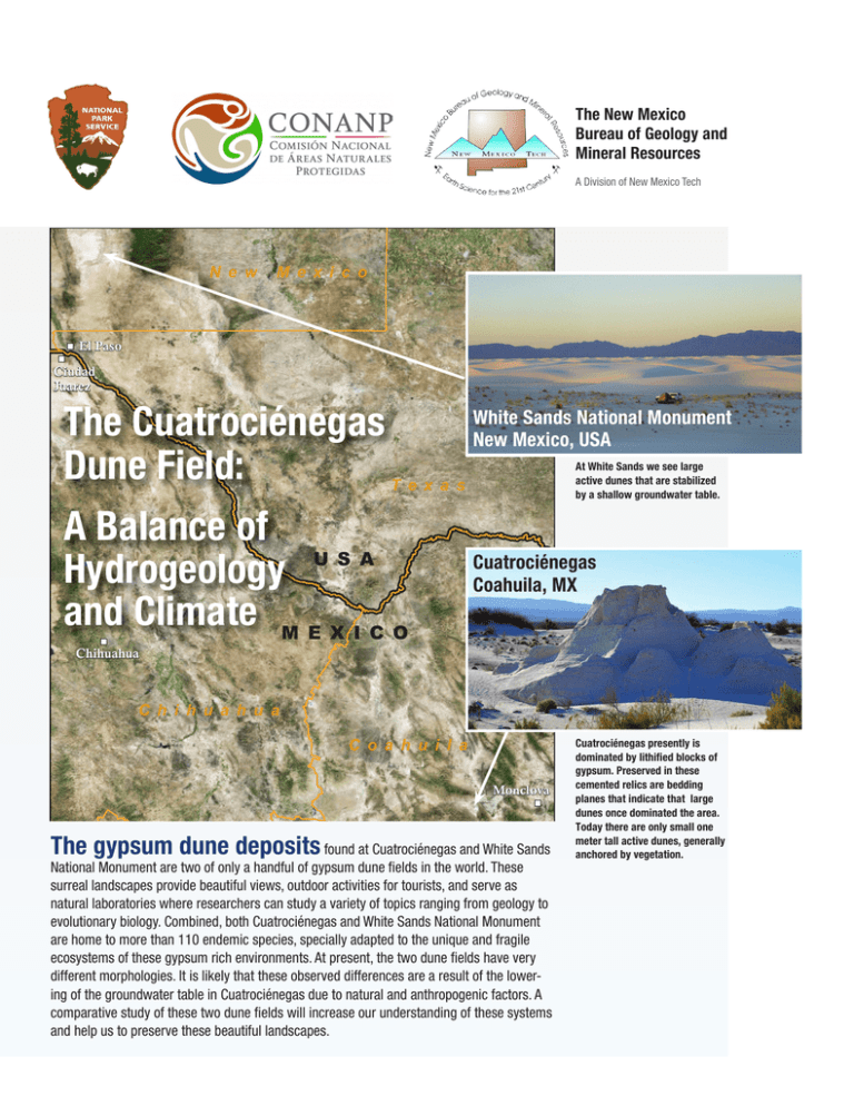
The New Mexico Bureau of Geology and Mineral Resources A Division of New Mexico Tech N e w M e x i c o El Paso Ciudad Juarez The Cuatrociénegas Dune Field: White Sands National Monument New Mexico, USA At White Sands we see large active dunes that are stabilized by a shallow groundwater table. T e x a s A Balance of Hydrogeology U S A and Climate M E X I C O Cuatrociénegas Coahuila, MX Chihuahua C h i h u a h u a C o a h u i l a Monclova The gypsum dune deposits found at Cuatrociénegas and White Sands National Monument are two of only a handful of gypsum dune fields in the world. These surreal landscapes provide beautiful views, outdoor activities for tourists, and serve as natural laboratories where researchers can study a variety of topics ranging from geology to evolutionary biology. Combined, both Cuatrociénegas and White Sands National Monument are home to more than 110 endemic species, specially adapted to the unique and fragile ecosystems of these gypsum rich environments. At present, the two dune fields have very different morphologies. It is likely that these observed differences are a result of the lowering of the groundwater table in Cuatrociénegas due to natural and anthropogenic factors. A comparative study of these two dune fields will increase our understanding of these systems and help us to preserve these beautiful landscapes. Cuatrociénegas presently is dominated by lithified blocks of gypsum. Preserved in these cemented relics are bedding planes that indicate that large dunes once dominated the area. Today there are only small one meter tall active dunes, generally anchored by vegetation. Gypsum Dune Fields: A Delicate Balance Conceptual Illustration of Cuatrociénegas Dune Field Process: This region of North America is one of the only places in the world that has the unique balance of geologic and climate conditions required to build and support gypsum dune fields. A delicate balance of environmental factors is required for gypsum to accumulate as sand. active dry sand Source of gypsum • Gypsum at both parks originates in the mountains surrounding the basins. The mountains are made up of gypsum rich rocks. interdunal zone inactive moist sand Gypsum transport accumulation thickness Dune field stability Not to sc Sierr Alami a tos basin-fill deposits it may rise to the surface where it discharges in spring pools, like Poza Churince. Hydrogeologists use conceptual models to depict the results from numerous tests and studies into a broader understanding of the study area. Sierra M adr e Sie rra le d el H un di do 5 gypsum dune 6 4 Laguna Grande Poza Churince 2 3 6 bedrock basin-fill sediments 2 confining layer limestone limestone bedrock Cuatrociénegas: Balance Tipped la Valle Cuatroc iéneg as San Sierr Ma a rco s Well Cuatro Ciénegas The dunes at Cuatrociénegas are no longer receiving as much gypsum sand as they are losing. At present there are only small active dunes present, generally held in place by vegetation. Evidence exists that there were much larger active dunes in the past. Throughout the gypsum dune field there are large cemented blocks of more resistant gypsum. Within these preserved blocks are the cross-bedding of large lithified dunes. There are numerous accounts of the dunes prior to the 1970s that describe active dunes like those seen at White Sands National Monument. While it is difficult to determine when the balance was tipped, it is researchers’ opinion that the shift Cretaceous siliciclastic Triassic granodiorite Initial studies on Cuatrociénegas Basin, published in 2005, suggested the water discharging in the basin was locally derived, originating primarily from the mountains surrounding the basin (Rodríguez et al., 2005). More recent publications have presented compelling evidence that Cuatrociénegas Basin is the discharge location for a much 1 1 percipitated gypsum crystals interdunal zone saturated accumulated gypsum 2 Cretaceous carbonates Cuatrociénegas: Conceptual Model 2 4.The gypsum rich water collects in Laguna Grande where it evaporates. Along the shores of the lake, gypsum is precipitated as the mineral Selenite. Selenite is a very soft mineral and is broken down by expansion and contraction caused by large temperature fluctuations. Hydrogeologic Conceptual Model: ua ag Fr • An arid climate is required to preserve the dunes because too much fresh rainwater can dissolve soluble gypsum crystals. • A shallow water table, supported by groundwater discharging in the basin, stabilizes the dunes. • The water under the dunes needs to be rich in dissolved gypsum so it is able to keep the dunes wet without dissolving the accumulated gypsum. • The same amount of gypsum (or more) is being added to the dunes as is being removed. Incoming gypsum sand needs to be equal or greater than that leaving the dune field. Val ale Gypsum dune field dynamics at White Sands At White Sands the behavior of accumulation and erosion, or the gypsum balance, is controlled by the water table. The accumulated gypsum in the dune field is held in place by the cohesion of the saturated sand. Only the active dunes on top of the accumulation surface migrate, while the saturated base of the dunefield remains spatially stable. water table • Gypsum is dissolved from the mountains by water that flows through gypsum rich rocks before discharging in the basin. • Gypsum is precipited on the edge of the dune field. • Wind transports gypsum onto the dune field. 1.Rain that falls on the mountains surrounding Cuatrociénegas, 5.Wind further breaks down the gypsum crystals and carries it as well as the ranges to the southwest (i.e. Sierra San Marcos, to the dune field where it is incorporated into the dunes. La Frague, Alamitos) recharges the aquifers. 6.The gypsum is held in place by a shallow groundwater table. 2.Groundwater slowly flows from the high mountains, through The water table was likely sustained by infiltration from sedimentary units rich in gypsum. The gypsum is dissolved Laguna Grande. This water is already so rich in dissolved into the water as it moves through the aquifer. gypsum that it is able to keep the dunes wet without dissolving the accumulated gypsum. 3.When groundwater reaches a fault or a break in the aquifer, broader groundwater flow system (Wolaver, 2008). The current hydrogeologic conceptual model is illustrated in the figure above. It suggests water enters the ground to the southwest of Cuatrociénegas Basin, in the high mountains where there is more precipitation. The water flows northeast through extensive regional aquifers that continue under the neighboring basins and mountains. The water that discharges near the dunes is forced to the surface by a fault that runs parallel to Sierra San Marcos. Lithified d une be d ding likely started within the past 100 years, as the water resources in the basin began to be exploited. For the Cuatrociénegas to support large dunes like those at White Sands we hypothesize that there was once a shallow water table in the dune field to facilitate the catchment of gypsum. Mineral analysis of a discolored, partially cemented crust found in the Cuatrociénegas dune field supports this hypothesis. Crusts with similar mineralogical composition can be found forming in the White Sands dune field. These crusts occur in the interdunal areas (the low points between the dunes) where the water table is closest to the surface. Moisture that is wicked to the surface supports thin biofilms which leave behind distinct chemical signatures. These crusts further support that at some point the Cuatrociénegas dune field was a wet system, similar to White Sands. 2 cm Interdunal crust sample What happened to the dune field? Gypsum Mining The largest impact on the dunes was likely the gypsum mining operations, which began on a relatively small scale in 1968. In 1979, mining increased to industrial levels until operations ceased in 1996, as result of environmental regulatory infractions. It has been estimated that approximately 80% of the gypsum from the dune field has been removed, either from mining or wind processes. Decline of Laguna Grande This has been an international collaborative study between the National Park Service (USA) and the National Commission of Protected Natural Areas (MEX) focusing on the hydrogeology found at the two gypsum sister parks. This project was funded by the National Park Service, and the New Mexico Bureau of Geology and Mineral Resources which is a non-regulatory research division of New Mexico Tech. 0.8 0.6 0.4 0.2 10 20 00 20 90 19 19 80 0 70 The next biggest impact to the dunes was likely the lowering of the groundwater table. Early reports indicate that much of the valley was covered by vast wetlands. The basin was artificially opened in 1898, and canals were later built to drain the wetlands for agricultural needs. Several previous studies have measured the volume of water leaving Cuatrociénegas Basin via the canals to be between 37 and 53 million m3 (billion liters) each year. When the wetlands were drained the water table throughout the entire basin was lowered. Without the shallow water table stabilizing the dunes, the gypsum was able to dry and blow away. 1.0 19 Draining of Wetlands Site of gypsum extraction in 1989 (Minkley, 1992). Area (km2) As recently as the 1970s, Laguna Grande was the largest body of water at Cuatrociénegas. Water discharging from Poza Churince collected in Laguna Grande where it would precipitate gypsum crystals, and support the shallow water table that stabilized the dunes. Using archived satellite imagery, we can observe the decline in the lake area over the past 40 years, until it finally went dry in 2010. Laguna Grande Surface Area decline High-Capacity Agricultural Pumping In 2002, large scale alfalfa farming began in the neighboring Hundido Valley, and at present approximately 19 km2 of alfalfa is being farmed. Rough estimates, based on the area of crops being grown and the water demands of alfalfa, suggest that nearly 12 million m3 of water are being pumped from the aquifers each year. Water extraction from Hundido Valley likely has an impact on spring flow in the Cuatrociénegas Basin. Regional groundwater flow is being intercepted in the Hundido Valley before it can make it to the Cuatrociénegas Basin. Long-term drought Another variable that is likely effecting the Cuatrociénegas Basin is the impact of climate change. Global weather patterns have been shifting, becoming increasingly variable. Spring flow at Cuatrociénegas is partially buffered from the impacts of decreased precipitation, as result of its long flow paths. The long groundwater flow paths protect the basin from the impact of short-term drought, however, spring flow will likely respond to long-term climate change. Authors: Ethan Mamer and Talon Newton, New Mexico Bureau of Geology and Mineral Resources Hundido Valley before large-scale farming (2001). The views and conclusions are those of the authors, and should not be interpreted as necessarily representing of the official policies, either expressed or implied, of CONANP, NPS, or NMBGMR. Citations: Rodríguez, A.A.A., Mijares, F.J.A., Ojeda, C.G., Morales, M.M., Hita, L.G., Zamarrón, G.H., Arellano, I.M., González, M.A.M., Flores, G.O., Almanza, P.G., Sánchez, R.L., López, J.L.P., Arzate, G.R., Fritz, P., Espinoza, J.R., 2005, Hydrogeologic study of the Hundido and Cuatrociénegas aquifers, Coahuila. National Water Commission, Mexico City Wolaver, B.D., 2008, Hydrogeology of the Cuatrociénegas Basin, Coahuila, Mexico: an integrative approach to arid karst aquifer delineation. Dissertation, The University of Texas at Austin Minckley W.L., 1992, Three decades near Cuatro Ciénegas, Mexico: photographic documentation and a plea for area conservation. JArizonaNevada Acad Sci 29:89–118 Center pivot irrigated agriculture Google Inc. (2013). Google Earth (Version 7.1.2.2041) [Software] Hundido Valley with industrial farming (2016). landsatlook.usgs.gov New Mexico Bureau of Geology and Mineral Resources geoinfo.nmt.edu /resources /water
