U N I O
advertisement

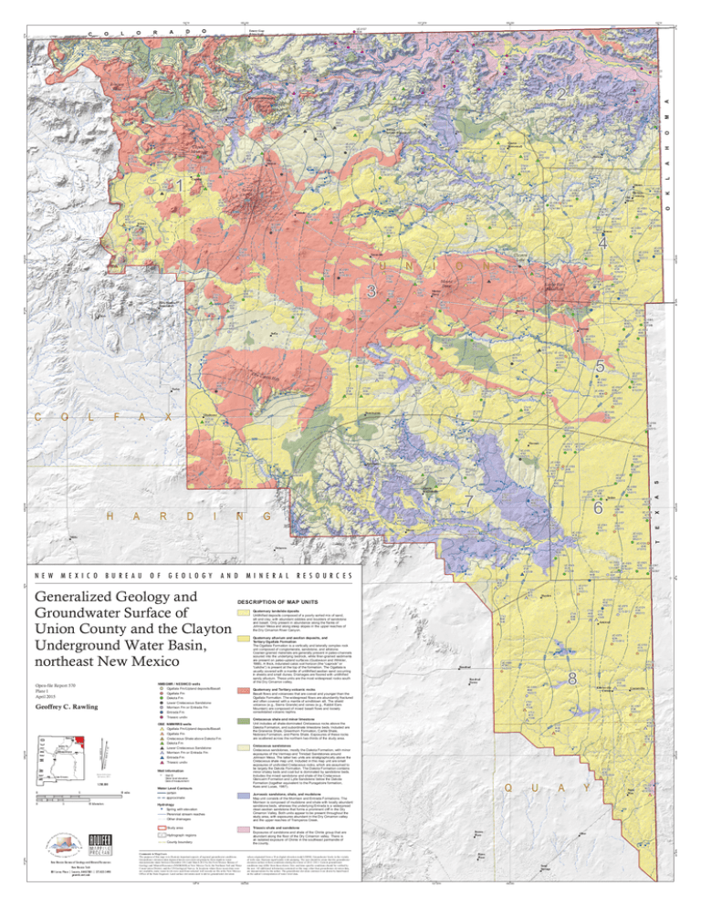
5300 4943 4900 49 00 Cre CT551 4804 8/1/1985 4879 e 7 Miera T 4720 M A GN E T I Triassic undiv Well Information Well ID Water level elevation Date of measurement 5 10 miles 10 kilometers Water Level Contours c ert ain Hydrology Spring wit h elevat ion P erennialst ream reach es Ot h erdrainag es 2 St udyarea 35°30'N Count yb oundary New Mexico Bureau of Geolo gy and Mineral Resources New Mexico Tech 801 Leroy Pla ce | Socorro, NM 87801 | 575 835 5490 geoinfo.nmt.edu Comments to Map Users Thepu r po s eo f thi sma p i sto i l l us tr a tei mpo r ta ntas pe c tsof r e gi ona lg r o und wate rc ond i ti on s . Gr o und wa tere l e va ti o nd atade pi c tedh e r e i nwe r ede r i ve dp r i ma r i l y fr o mde pthtowa te r me as ur e me n tsta k e nb e twe enDe c e mbe r20 12a n dMa r ch2 01 3by theNe wMe xi c o Bu r e a u of Ge ol ogy a n dMi n e r a l Re s o ur c es( NMBGMR)a t Ne wMe xi c o Te ch ,th eNor th e a s t Soi la n dWa te r Cons e r va ti o nDi s tr i c t,a n dtheUSGe ol ogi c a lSur ve y.I nl oc a ti on swh e r ethe s er e c e ntda tawe r e n ot a va i l a bl e , s ta ti cwa te rl e ve l swe r eus e dfr oms e l e c te dwe l lr e c or d sonfi l ea t theNe wMe xi c o Off i c eof th eSta teEng i ne e r .La nds ur fa c ee l e va ti onsus e dto d e r i v egr ou n dwa te re l e va ti on 104°W Roseb ud Roseb ud Farms 37°N reek UC-0098 4660 1/6/2013 M A izo O d Cany on H 470 0 A L O 4,05 0,0 00 47 00 K 4800 a 4571 4540 36°30'N UC-0124 4190 3/8/2013 Amistad UC-0100 4174 1/6/2013 4492 8 4668 CT1227 4110 <1938 Centerville Corner CT1189 4181 1/1/1965 Centerville UC-0097 4198 1/6/2013 4559 CT53 4615 <1940 CT1273 4158 8/2/2008 CT77 00 45 4428 1940 UC-0138 4158 12/17/2012 4419 Q U A Y CT1329 4250 12/15/2008 Nara Visa CT1000 4072 4/23/2007 4075 4089 Brown Place Obar 3881 3886 Bates Place va l ue so r i gi na te df r o ma1 0mdi g i ta le l e v ati o nmod el ( DEM) .Gr o und waterl e ve l si nth ev i c i n i ty of we l l sma y fl uc tu a tes i gn i fi c a n tl y wi thpu mp i ng .Theus e rs h o ul dbea wa r eth attheg r ou n d water e l e va ti o ns ur fa c er efl e c tsc on di ti onsdur i ngthewi nte ro f 2 01 2–20 13 .Cu r r en tg r ou n dwa te r c ond i ti on sma y di ffe rfr o mth os es hown. Si te -a ndti me s pe c i fi cc on di ti onss h o ul db ev e r i fi e dby th eus e r . Al la d di ti ona li nfo r mati o nc on tai ne do nth i sma p, o th e rtha ngr o und wa te rel eva ti o nd a ta , a r ei n te r pr eta ti onsby th ea u th or .Th egr ou nd wa te re l e va ti onc ontou r swe r ed r a wnby h a ndba s ed onthea uthor ’si nte r pr e ta ti o nof wa terl e ve lda ta . 600,000 CT78 4393 <1909 UC-0078 4247 12/13/2012 UC-0079 4294 12/13/2012 4540 4530 4498 CT65 4651 <1906 Triassic shale and sandstone Exposures of sandst oneandsh aleof t h eCh inleg roup t h atare a b undantalong t h efloor of t h eDryCim arron v alley.Th ereis a n isolat edexposureof Ch inlein t h esout h eastpanh andleof t h ec ount y. Hy drog raph reg ions CT49 4406 <1962 UC-0125 4332 3/8/2013 4563 Jurrassic sandstone, shale, and mudstone Gallegos Map unitc onsist s of t h eMorrison andEnt radaForm at ions.Th e Morrison is c om posedof m udst oneandsh alewit h loc allyab undant sandst oneb eds,wh ereas t h eunderlying Ent radais awidespread c lean aeolian sandst onet h atform s aprom inentc liff in t h eDry Cim arron Valley .Bot h unit s appeart o b epresentt h roug h outt he Campana st udyarea,wit h ex posures ab undantin t h eDryCim arron valley a ndt h eupperreac h es of Tram peros Creek. a pproxim at e Hayden 4562 UC-0005 4292 UC-0047 1/6/2013 4293 2/16/2007 3,95 0,0 00 Ent radaFm UC-0058 UC-0026 4357 4299 1/31/1991 9/14/2011 UC-0059 4341 1/31/1991 UC-0102 4448 1/3/2012 CT46 4588 1948 UC-0099 4739 1/6/2013 UC-0025 4257 9/8/2011 UC-0126 4240 3/7/2013 UC-0101 4472 1/6/2013 CT43 4860 1946 Cretaceous sandstones Cret ac eous sandst ones,m ost lyt h eDakot aForm at ion,wit h m inor e xposures of t h eVerm ej o andTrinidadSandst ones around J oh nson Mesa.Th elat t ert wo unit s arest rat ig raph ic allyab ov et he Cret ac eous sh alem ap unit .I nc ludedin t h is m ap unitaresm all e xposures of undividedCret ac eous roc ks,wh ic h areassum edt o b elarg elyt h eDakot aForm at ion.Th eDakot aForm at ion c ont ains m inorsh aleyb eds andc oalb utis dom inat edb ysandst oneb eds. I nc ludes t h em ix edsandst oneandsh aleof t h eCret ac eous Glenc airn Form at ion andLy t leSandst oneb elowt h eDakot a Form at ion ( t og et h er equiv alentt ot h eP urag at oireform at ion, Kues andLucas,1987) . L owerCret ac eous Sandst one Morrison Fm or Ent radaFm C NO R T H 7° 32 ' T RU E N O RT H Gr a nd e M EXICO NEW Rio 5 4771 UC-0127 4305 3/7/2013 35°30'N 36°N 3,95 0,0 00 Cret ac eous Sh aleab oveDakot aFm Dakot aFm CT833 4672 1975 UC-0128 4218 2/4/2009 4500 0 Og allalaFm Pecos R i ver 0 4921 UC-0049 4521 3/1/2006 CT1457 4704 4/3/2009 Cretaceous shale and minor limestone Unitinc ludes allsh aledom inat edCret aceous roc ks ab ovet he Dakot aForm at ion,andsub ordinat elim est oneb eds.I nc ludedare t h eGraneros Sh ale,Greenh orn Form at ion,CarlileSh ale, Niob raraForm at ion,andP ierreSh ale.Ex posures of t h eseroc ks a resc at t eredac ross t h enort h ern t wot h irds of t h est udyarea. OSE NMWRRS wells Og allalaFm / Uplanddeposit s/ Basalt 1:200,000 4902 UC-0129 4237 2/9/2011 UC-0067 4380 2/5/1981 UC-0044 4342 1/6/2013 UC-0019 4435 9/16/2011 UC-0006 4244 1/6/2013 UC-0057 4655 1/27/1996 4703 4736 4800 4900 Triassic undiv Las Cruces 4727 4767 Quaternary and Tertiary volcanic rocks Basaltflows andvolc anoes t h atarec oev alandyoung ert h an t he Og allalaForm at ion.Th ewidespreadflows areab undant lyfrac t ured a ndoft en c ov eredwit h am ant leof windb lown silt .Th esh ield v olc anos ( e. g. ,SierraGrande)andc ones ( e. g. ,Rab b itEars Mount ain)arec om posedof m ix edb asaltflows andloosely c onsolidat edvolc anic t eph ra. Ent radaFm Approximate mean decli nation, 2015 4657 CT835 4820 1952 Quaternary alluvium and aeolian deposits, and Tertiary Ogallala Formation Th eOg allalaForm at ion is avert ic allyandlat erallyc om plexroc k u nitc om posedof c ong lom erat e,sandst one,andsilt st one. Coarserg rainedm at erials areg enerallypresentin paleoc h annels sc ouredint ot h eunderly ing b edroc k,wh ilefinerg rainedsedim ent s a representon paleouplandsurfac es ( Gust av son andWinkler, 1 988) .At h ic k,indurat edc alc ic soilh orizon ( t h e“c aproc k”or “c alic h e”)is presentatt h et op of t h eform at ion.Th eOg allalais u suallyc overedwit h am ant leof unlit h ifiedaeolian sandoc c urring in sh eet s andsm alldunes.Drainag es areflooredwit h unlit h ified sandyalluv ium .Th eseunit s aret h em ostwidespreadroc ks sout h of t h eDryCim arron valley . L owerCret ac eous Sandst one Mosquero Morrison Fm or Ent radaFm Clayton os C re e k 4847 Quaternary landslide dposits Unlit h ifieddeposit s c om posedof apoorlysort edm ixof sand, Albert silt andc lay ,wit h ab undantc ob b les andb oulders of sandst one a ndb asalt .Onlypresentin ab undanc ealong t h eflanks of J oh nson Mesaandalong st eep slopes in t h eupperreac h es of t h eDryCim arron Riv er Canyon. Og allalaFm Dakot aFm Raton 4926 4803 DESCRIPTION OF MAP UNITS NMBGMR / NESWCD wells Og allalaFm / Uplanddeposit s/ Basalt UC-0038 UC-0027 4371 4386 2/15/2012 9/14/2011 Sedan 6 4660 UC-0007 4292 1/6/2013 UC-0037 4404 1/2/2012 4663 CT241 4588 10/4/1956 4717 Bueyer os Solano r a mp er 4811 NEW MEXICO BUREAU OF GEOLOGY AND MI NERAL RESOURCES Geoffrey C. Rawling 4799 ek 4700 4854 Roy Cr e UC-0103 4656 1/6/2013 4879 UC-0136 4753 12/17/2012 Dehaven Generalized Geology and Groundwater Surface of Union County and the Clayton Underground Water Basin, northeast New Mexico CT682 4791 9/1/1946 4761 Mills Sabino Pin a4716 te s UC-0001 4383 1/6/2013 k CT642 4909 unknown esi t 4812 UC-0009 4512 1/3/2012 UC-0066 4491 UC-0056 3/15/2011 4499 UC-0008 2/9/2011 4617 1/6/2013 UC-0045 4562 8/27/2009 5040 4900 4887 UC-0105 4763 1/6/2013 4600 M a G UC-0104 4947 1/6/2013 CT666 5028 unknown 4978 4942 UC-0010 4519 1/6/2013 be Garcia (historical) Thomas 5021 CT130 5237 unknown CT1348 5115 7/7/2009 5100 N CT118 4851 <1951 4800 5421 UC-0106 4398 1/6/2013 UC-0039 4661 1/6/2013 4,00 0,0 00 5500 5546 TU1739 5366 5/29/2008 5155 UC-0048 4534 2/28/2006 36°N 5400 5554 Beenham UC-0069 5419 12/11/2012 00 52 I 5097 5109 5058 CT1775 5290 7/23/2011 D 5125 500 0 C r ee k 5259 530 0 U te 00 58 R 5137 5135 UC-0033 4582 1/6/2013 S 511 3 UC-0030 4611 9/15/2011 UC-0041 4598 2/10/2011 A 5374 0 490 00 46 UC-0012 4547 1/6/2013 X 5137 5141 UC-0042 4643 2/10/2011 UC-0052 4644 2/15/2001 CT416 4984 <1960 4600 5473 5386 0 500 dD raw 470 0 5425 00 54 5556 5559 Carrizo Cree k UC-0107 5171 1/6/2013 5177 5470 5420 5603 5 4500 5438 CT542 4894 <1920 4700 00 55 San 4 UC-0112 4600 1/6/2013 E 510 0 UC-0109 5107 1/6/2013 5600 5661 TU1788 5693 3/20/2009 5059 5100 5660 5687 4920 CT1616 4932 12/8/2010 UC-0014 4953 1/6/2013 UC-0013 4912 1/6/2013 UC-0071 5019 12/11/2012 5200 5790 UC-0034 4890 8/31/2011 5050 CT160 5432 <1950 Pennington 0 570 5029 5091 UC-0070 5255 12/11/2012 UC-0064 4574 1/22/1991 UC-0065 UC-0113 4594 4659 2/5/1986 1/6/2013 UC-0002 4565 0 1/6/2013 60 Clayton 5068 540 0 CT189 5595 <1960 5762 5769 5072 5179 Pe r i co C r ee k CT284 5503 1962 CT164 5706 <1960 5800 5886 5201 5300 UC-0084 5380 12/18/2012 5400 6100 5900 5976 5945 5334 UC-0036 4542 1/6/2013 T 5457 UC-0046 4756 2/4/1986 UC-0003 4633 1/6/2013 UC-0063 4889 1/30/1986 5100 5083 Royce 5386 5144 55 00 6600 6800 6500 5998 00 60 Rabbit Ears Mountain UC-0018 4580 1/6/2013 UC-0016 4571 1/6/2013 UC-0015 4704 1/6/2013 UC-0055 4748 2/4/1986 UC-0068 56 00 37°N 7000 Gladstone TU1530 5832 2/7/2007 UC-0108 5776 1/6/2013 UC-0072 5776 12/11/2012 500 0 UC-0051 4627 2/14/2006 UC-0054 4676 1/24/1996 UC-0035 4724 8/31/2011 UC-0040 4724 1/25/2011 5062 CT145 5132 <1956 0 520 5150 12/19/2012 UC-0115 5491 1/6/2013 CT287 5560 1973 5093 UC-0095 5217 12/18/2012 CT110 5379 3/1/1992 5286 5286 UC-0111 5677 1/4/2012 lo s H i lls 530 0 Clayton Lake 5105 Mount Dor a 5501 4 UC-0017 4878 1/6/2013 47 00 CT583 5481 <1971 CT168 5646 unknown Mount Dora CT602 5581 <1960 N UC-0043 4675 1/6/2013 4800 Pal o B la n c o Cre ek UC-0114 5737 1/6/2013 CT603 5564 <1960 O UC-0050 4642 2/22/2001 UC-0022 4681 9/8/2011 Seneca 5102 00 49 CT584 5672 <1960 I 5200 ek S enec a C re 5502 5570 5137 Albuquerque CT1278 5302 4/18/2008 4666 1/6/2013 Old Moses 4901 UC-0062 4794 1/30/1986 A 00 53 UC-0110 5866 1/6/2013 X 3 N CT588 5743 <1960 5600 A CT536 5703 1955 UC-0073 5972 12/11/2012 Sofia 0 620 6013 Santa Fe UC-0053 5051 1/24/1996 UC-0061 5013 1/30/1986 os C lam reek 6200 UC-0131 6155 8/8/2012 Farley Open-file Report 570 Plate 1 April 2015 5049 UC-0132 5130 3/6/2013 CT253 5347 1932 4640 4761 UC-0004 McNees Crossing 430 0 560 0 5677 5698 UC-0116 5425 1/6/2013 UC-0120 4633 1/6/2013 4606 Moses 4741 4300 5622 5683 520 0 53 00 5059 5121 5120 4805 4879 UC-0060 4940 1/30/1986 5000 6300 6302 UC-0088 5876 12/18/2012 UC-0087 6131 12/18/2012 Don C ar 4,00 0,0 00 5352 5395 5722 5722 U 6100 CT565 6321 1960 6400 6396 6043 6030 A 50 00 Ra r k f ae l C e e 5701 5720 Grenville 6064 H 4600 5000 5600 600 0 5780 Creek p m 540 0 6600 5853 5853 5146 4480 4882 00 50 5891 5744 5414 5433 5563 UC-0089 5724 12/18/2012 UC-0130 6395 8/8/2012 CT561 6449 1918 Chico F CT231 6038 <1930 CT601 6020 <1960 6382 L UC-0083 6091 12/18/2012 6300 CT1682 6245 4/11/2011 Palo Blanco (historical) O 5804 5867 5419 C a Ro 4712 4821 Atencio UC-0118 4966 1/6/2013 5100 5160 5143 5562 5717 5772 0 580 UC-0086 6272 12/18/2012 6700 7135 5821 0 610 5209 5589 Ca rr zo CT435 4402 7/11/1991 4811 CT776 4931 <1972 CT854 5208 6/8/2006 5266 5512 CT526 5211 8/15/1930 CT755 5250 1944 5782 6096 Grande 50 00 5361 CT400 4448 3/1/1952 4816 4900 7200 UC-0117 6709 1/6/2013 6154 6147 6096 5599 5360 5026 4957 CT773 4771 1992 CT777 4886 1992 4700 Sierra Grande UC-0076 5740 12/18/2012 5382 4479 4480 5175 Cuates CT797 (historical) 5328 <1972 UC-0123 4329 1/6/2013 4500 4501 ru 6155 6700 CT1711 7339 6/4/2004 C 6262 6237 6223 6146 6099 6240 6202 6143 6132 611 3 0 700 UC-0133 7016 12/12/2012 4,05 0,0 00 UC-0074 6416 12/12/2012 5378 UC-0085 5479 12/14/2012 5400 5499 55 00 5368 UC-0094 4358 4500 5289 Guy 5721 5000 5234 4900 Cor CT408 6785 1947 CT1121 6921 6/15/2007 Kiowa 36°30'N 6300 CT1690 6748 <1930 5701 5620 00 59 1 Des Moines 64 00 CT955 6780 12/12/2006 6697 CT367 6772 1978 Capulin 6642 5487 5688 6202 6201 6800 ek 0 680 UC-0119 6786 1/6/2013 CT774 6501 1992 57 00 Willow Springs (historical) 5845 UC-0096 55 00 5682 12/18/2012 2 48 00 4485 5100 6812 12/12/2012 CT574 6642 7/3/1962 UC-0075 6013 12/12/2012 5800 5800 CT440 6044 <1930 CT452 6186 <1930 CT411 6552 <1930 5290 4782 4804 4600 00 65 Capulin Mountain CT442 5967 <1930 CT736 5219 1964 UC-0121 4973 1/6/2013 4914 0 490 68 00 7030 CT446 6237 1965 6200 5960 00 58 CT1292 5899 12/16/2008 CT374 6436 <1930 CT723 5787 9/1/1963 UC-0122 5092 1/6/2013 5300 7083 6525 6526 CT735 5777 10/2/1957 0 560 7200 6897 UC-0134 7395 6100 Emery Peak CT1441 6398 6342 Folsom 1/29/2009 6403 CT375 6388 6617 CT373 <1940 6421 1990 6986 6808 7000 0 690 7020 5900 er Dry Ci marr o n Riv 5484 4588 4400 12/19/2012 CT309 4743 1959 00 49 4595 4500 UC-0093 4695 12/19/2012 CT304 4731 1967 00 52 e Archuleta C r 7000 CT355 6132 1987 670 0 7322 7313 CT20 6915 6/2/1980 5940 5800 UC-0091 5526 12/19/2012 5300 5400 Madison (historical) 6782 7281 5800 6290 00 68 7327 UC-0090 5697 12/19/2012 57 CT1293 00 5701 12/16/2008 5600 4525 0 470 4800 CT1695 4902 5/16/2011 103°W 4934 5100 6628 6695 6200 7504 7041 7005 64 00 60 00 660 0 era Cr e ek 0 660 7138 7509 7200 6800 00 65 7400 00 72 CT905 7641 7674 <1955 7000 6985 CT1715 6141 3/29/2011 CT521 4866 8/1/1976 5100 57 00 k ree 7600 7000 ch in Tr Johnson Mesa Oak C 00 550 0 7154 CT1636 6096 1/25/2011 5600 5200 UC-0092 4783 12/19/2012 550 0 00 70 7051 UC-0135 7574 12/12/2012 0 580 CT733 5707 1952 UC-0081 UC-0082 5294 12/14/2012 UC-0080 5256 5248 12/14/2012 12/14/2012 5259 CT310 5749 53 1/20/1991 4900 74 00 7347 CT315 5310 unknown UC-0137 5334 12/14/2012 650,000 5400 00 76 CT1114 7700 9/26/2007 7628 6892 6866 6809 00 68 Yankee 7371 7496 7443 Emery Gap (historical) 6200 7536 6400 6600 103°30'W 0 620 00 72 L O C O D A R O 600,000 59 00 104°W Sand Springs 103°30'W 650,000


