Design of an Underwater Mine Detection System
advertisement
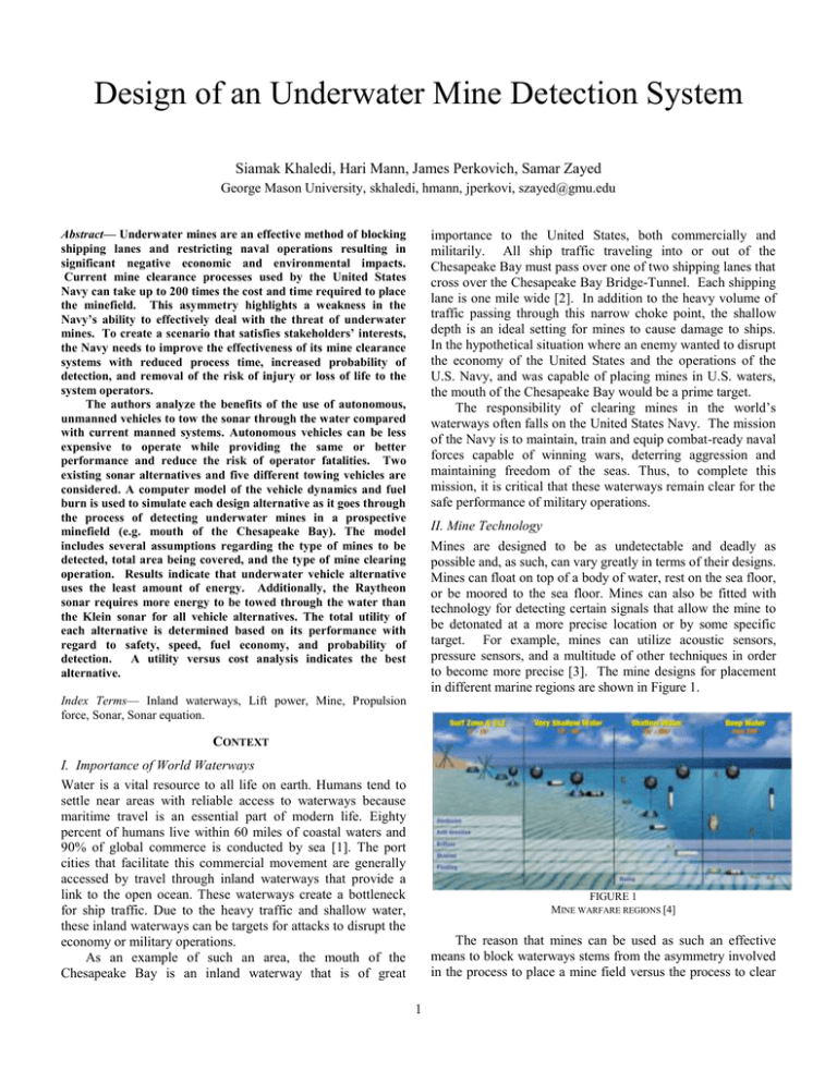
Design of an Underwater Mine Detection System Siamak Khaledi, Hari Mann, James Perkovich, Samar Zayed George Mason University, skhaledi, hmann, jperkovi, szayed@gmu.edu importance to the United States, both commercially and militarily. All ship traffic traveling into or out of the Chesapeake Bay must pass over one of two shipping lanes that cross over the Chesapeake Bay Bridge-Tunnel. Each shipping lane is one mile wide [2]. In addition to the heavy volume of traffic passing through this narrow choke point, the shallow depth is an ideal setting for mines to cause damage to ships. In the hypothetical situation where an enemy wanted to disrupt the economy of the United States and the operations of the U.S. Navy, and was capable of placing mines in U.S. waters, the mouth of the Chesapeake Bay would be a prime target. The responsibility of clearing mines in the world’s waterways often falls on the United States Navy. The mission of the Navy is to maintain, train and equip combat-ready naval forces capable of winning wars, deterring aggression and maintaining freedom of the seas. Thus, to complete this mission, it is critical that these waterways remain clear for the safe performance of military operations. Abstract— Underwater mines are an effective method of blocking shipping lanes and restricting naval operations resulting in significant negative economic and environmental impacts. Current mine clearance processes used by the United States Navy can take up to 200 times the cost and time required to place the minefield. This asymmetry highlights a weakness in the Navy’s ability to effectively deal with the threat of underwater mines. To create a scenario that satisfies stakeholders’ interests, the Navy needs to improve the effectiveness of its mine clearance systems with reduced process time, increased probability of detection, and removal of the risk of injury or loss of life to the system operators. The authors analyze the benefits of the use of autonomous, unmanned vehicles to tow the sonar through the water compared with current manned systems. Autonomous vehicles can be less expensive to operate while providing the same or better performance and reduce the risk of operator fatalities. Two existing sonar alternatives and five different towing vehicles are considered. A computer model of the vehicle dynamics and fuel burn is used to simulate each design alternative as it goes through the process of detecting underwater mines in a prospective minefield (e.g. mouth of the Chesapeake Bay). The model includes several assumptions regarding the type of mines to be detected, total area being covered, and the type of mine clearing operation. Results indicate that underwater vehicle alternative uses the least amount of energy. Additionally, the Raytheon sonar requires more energy to be towed through the water than the Klein sonar for all vehicle alternatives. The total utility of each alternative is determined based on its performance with regard to safety, speed, fuel economy, and probability of detection. A utility versus cost analysis indicates the best alternative. II. Mine Technology Mines are designed to be as undetectable and deadly as possible and, as such, can vary greatly in terms of their designs. Mines can float on top of a body of water, rest on the sea floor, or be moored to the sea floor. Mines can also be fitted with technology for detecting certain signals that allow the mine to be detonated at a more precise location or by some specific target. For example, mines can utilize acoustic sensors, pressure sensors, and a multitude of other techniques in order to become more precise [3]. The mine designs for placement in different marine regions are shown in Figure 1. Index Terms— Inland waterways, Lift power, Mine, Propulsion force, Sonar, Sonar equation. CONTEXT I. Importance of World Waterways Water is a vital resource to all life on earth. Humans tend to settle near areas with reliable access to waterways because maritime travel is an essential part of modern life. Eighty percent of humans live within 60 miles of coastal waters and 90% of global commerce is conducted by sea [1]. The port cities that facilitate this commercial movement are generally accessed by travel through inland waterways that provide a link to the open ocean. These waterways create a bottleneck for ship traffic. Due to the heavy traffic and shallow water, these inland waterways can be targets for attacks to disrupt the economy or military operations. As an example of such an area, the mouth of the Chesapeake Bay is an inland waterway that is of great FIGURE 1 MINE WARFARE REGIONS [4] The reason that mines can be used as such an effective means to block waterways stems from the asymmetry involved in the process to place a mine field versus the process to clear 1 one. Clearing a minefield can take up to 200 times longer and cost up to 200 times more than laying a minefield [5]. objective is to clear underwater mines in a safe, timely and cost effective manner. The DoD requires the proposed system to be interoperable with the existing defense and tracking systems [6]. Beneficiaries are the users of the waterways. They benefit from the free and safe movement throughout the waterways of the world, which is provided by the system customers. Beneficiaries include the ship traffic through the water, such as military and commercial ships. The military traffic’s objective is to conduct missions in a safe and timely fashion, while the commercial traffic seeks safe transportation through the waterways. The final group that is a secondary stakeholder is the minelayers. Minelayers may include strategic enemy countries, as well as terrorist groups. Enemies seek to deny freedom of movement to the U.S. Navy forces. Terrorist groups carry out planned attacks to cause widespread chaos, seek the attention of media, and obtain worldwide recognition. The mine detection system does not seek to satisfy the objective of minelayers. III. Current Mine Clearing Techniques Mine clearance systems that are most commonly in use by the U.S. Navy today are time consuming and expensive. An MH60S helicopter flies to the site of the minefield and deploys a sonar to be towed by the helicopter through the water over the minefield. The helicopter then returns to base and the collected data is examined for signs of mine-like objects. The helicopter makes a second pass over the mine field to eliminate the mines, and finally makes a third pass to verify that the mines are destroyed [3]. This process requires three distinct flights of the helicopter and a manned crew to operate the helicopter and sonar. IV. Project Scope Determining the actual time and cost required to clear any given mine field is difficult because there are so many variables that can affect the situation. These factors include the size of the mine field, type of mines, whether or not the enemy is trying to stop the operation (covert or overt operation), the natural environment of the minefield, and the type of sensors being used. In order to narrow the scope of this project, the aforementioned factors have been limited. The simulation will examine a vehicle and sonar system operating in a 1 square mile area in the mouth of the Chesapeake Bay, the mission is overt, the system will search for moored mines in the water column, and the objective is to clear a path as rapidly as possible. Although the scope of the project is narrowed, the idea is that when the simulation is complete, it can be run with different inputs to simulate different situations that were not necessarily used in this project. III. Tertiary Stakeholders Three groups of people make up the tertiary stakeholders. System servicemen are trainers and maintainers who must adapt to new procedures and tasks. United States taxpayers seek national security from the government and wish to maximize the value of investment. Environmental groups seek to protect humans, animals, and the environment from harm. IV. Stakeholder Tensions Interactions among stakeholders expose the conflicts in their respective interests, and result in stakeholder tensions. These tensions are broken into Internal and External levels. Internal tensions include tensions between system operators and system customers, with the system operators having concerns over operational safety, whereas the main objective of system customers is to decrease the time and cost of mine clearance. In addition, servicemen and system customers also experience internal tensions. Current training staff may not be able to effectively train the operators for the new system, and the new system may add significant burden to maintenance procedures. External tensions include tensions between environmental groups and system customers. Sound waves produced by the sonar employed by the Navy have previously been lethal to marine animals on several occasions. NRDC has been a leader in the battle to regulate sonar use and protect underwater species from its harmful effects [7]. Other external tensions include tensions between taxpayers and system customers, with the taxpayers consistently seeking value of investment on the money they provide through taxes. STAKEHOLDER ANALYSIS I. Primary Stakeholders The primary stakeholders of the system are system operators, whose safety is at stake. Examples of system operators include those in charge of the vehicles involved in the mine clearance process; such as sailors and pilots. The major objective for system operators is to have their operational safety increased. II. Secondary Stakeholders Designers and manufacturers include the groups that design the entire system, as well as the manufacturers of all the applied components. Components include the vehicles involved in the process (such as boats or helicopters), the mine detection unit (sonar), the mine clearance unit (neutralizer), and all other physical and virtual components involved in the system. The objective of designers and manufacturers is to grow their market share, and they do so by providing a cost effective solution to war fighters. The next group that is considered a secondary stakeholder is the system customers, who include the U.S. Navy and the Department of Defense (DoD). As a part of homeland defense, the U.S. Navy functions under the supervision of the Department of Defense and deploys mine clearance systems to clear waterways that are suspected to have mines. The Navy’s PROBLEM AND NEED STATEMENTS I. Problem Statement Underwater mines are a very effective method of blocking shipping lanes, restricting naval operations. They are a challenge to identify, classify, and neutralize. This threat can 2 have severe negative effects on the world economy and the ability of the world’s Navies to conduct necessary operations. Because of the capabilities and worldwide influence of the United States, the responsibility of clearing mines often falls on the U.S. Navy. As explained in the gap analysis section, today’s technology to clear waterways of mines is slow and costly when compared to what it takes minelayers to store the mines in the waterways. Underwater mines also pose negative environmental impacts, by exposing the underwater species and the natural environment to the danger of explosion. II. Need Statement There is a need for the U.S Navy to improve the effectiveness of mine clearance systems. The U.S. Navy needs to reduce the operational cost and improve the rate of detection and neutralization to prevent the threat of underwater mines from increasing. Furthermore, there is a need to remove the safety risk of personnel in a mine clearance operation. Making the investment of time and money immediately will end up saving time and money in the future if an event occurs where the U.S. Navy needs to clear an area of underwater mines. The current investment will also reduce the negative economic impact that underwater mines could potentially cause to the U.S. or world economy [8]. CONCEPT OF OPERATIONS I. Limitations When designing a mine countermeasure system, there are some important limitations that should be noted. Any system that is looking for objects in the water is limited to the currently available sonar technology. Other technologies that are traditionally used to find objects at a distance are not effective underwater. Sonar has a much longer range than either radar or optical instruments (cameras) due to the physical nature of the way light waves, radio waves and sound waves move through water. For this reason, the system being designed must use sonar to detect underwater mines. The new mine detection system will make use of sonar systems and vehicle systems that are already in production. More information on the sonar and vehicle systems that are considered for use in the system can be found in the following section. II. Design Alternatives Each system alternative will consist of two main components; a vehicle alternative, and a sonar alternative. Sonar Alternatives: The first alternative, the Raytheon AN/AQS-20A Minehunting Sonar System, is considered the standard in mine hunting technology by the U.S. Navy [9]. The system does not have propulsion capabilities and therefore must be towed through the water. The AN/AQS-20A simultaneously uses a combination of five different sonar systems while moving through the water to get a picture of both the sea floor beneath the vehicle, and the water column in front of it. The second sonar alternative considered is the L-3 Klein Systems 5900. The Klein sonar has a dual side scan sonar and an optional gap filler sonar. The Klein option is smaller in size and weighs less than the Raytheon sonar. All vehicle alternatives must be able to tow the AN/AQS-20A or Klein 5900 through the water. Underwater Vehicle Alternative: The underwater alternative consists of an underwater vehicle that is capable of towing either of the two sonar alternatives through the water. The underwater alternative that is considered for this project is the Lockheed Martin Remote Multi-Mission Vehicle (RMMV). The RMMV is powered by a diesel engine and has a snorkel that extends beyond the surface of the water. Its capabilities include the ability to stay in water for up to 24 hours, tow sonar through the water, and autonomously travel pre-programmed routes [10]. Surface Vehicle Alternatives: The surface alternative will consist of an unmanned surface craft towing the underwater sonar. The two surface alternatives that are evaluated for the system design are the Meggitt Hammerhead and the Textron Fleet-Class Common Unmanned Surface Vessel. Similar to the underwater alternative, both surface alternatives area able to tow heavy loads, and travel along pre-programmed routes through the use of their GPS systems. The Meggitt boat can travel at speeds up to 35 knots, and has more than eight hours of endurance [11]. The Textron boat is much larger and can carry heavier loads. It can haul up to 5,000 pounds while traveling at 10 knots, and has a range of 1,200 miles [12]. Airborne Vehicle Alternatives: The airborne alternatives consist of an unmanned helicopter towing the underwater sonar. There are two unmanned helicopters available that are evaluated for use, the U.S. Navy’s Fire Scout and the U.S. Marine Corp’s K-Max. Both unmanned helicopters are currently being used by the U.S. military. Similar to the underwater and the surface alternatives, the unmanned helicopter can carry heavy loads, travel through preprogrammed GPS positions, and communicate with human observers through conventional radio communications. The Fire Scout can lift up to 2,650 pounds and stay in the air for up to eight hours, while the heavy duty K-Max can lift up to 6,000 pounds and has a flight endurance of more than 2.5 hours [13],[14]. SIMULATION The goal of the simulation is to determine the time it takes for each alternative to scan the minefield, how much energy is used, and what the probability of detection is. To achieve these outputs, the simulation consists of two main models: The energy consumption model and the probability of detection model. All alternatives were run through a simulation of mine detection over one square mile in the previously mentioned Chesapeake Bay area. An area of one square mile was chosen because it is the width of the shipping lanes, and therefore, is wide enough to allow ship traffic in two directions. If there 3 was a situation where a suspected mine field was halting the movement of Navy ships, clearing a distance of one mile wide would be sufficient to allow passage in both directions. In addition, one square mile is a simplified baseline measurement that can be used as a conversion to project the clearance of a larger area if the situation exists. Each system alternative consists of one of the vehicle alternatives towing one of the sonar alternatives. Evaluating five vehicle alternatives and two different sonar alternatives totals ten different alternatives that will be run through the simulation. All ten alternatives are also compared to the current system. The possible combinations that make up each system alternative are shown in Table I. I. Energy Consumption Model The energy consumption model was made using a free body diagram for each system alternative. The free body diagram shows all the forces acting on the vehicle component of the system while it moves through space. The free body diagram for the airborne alternative is illustrated in Figures 3. Diagrams for the other alternatives are similar with the exception that force of gravity is opposed by buoyancy force rather than lift force. The Equation used to calculate propulsion force for all vehicle alternatives is displayed in (1), and drag for each vehicle alternative and for the towed sonar is calculated using (2). TABLE I DESIGN OF EXPERIMENT FIGURE 3 FORCES ACTING ON THE AIRBORNE ALTERNATIVE ( ) (1) (2) Random inputs that affect the simulation are wind and water current. Each random input affects the hydrodynamics and aerodynamics of the system in different ways, depending on the vehicle alternative. The search area and underwater topography of the search area will be constant inputs. A block diagram showing the simulation inputs and outputs is shown in Figure 2. As the system moves through space, the propulsion force must overcome the force of drag on the vehicle body and on the body of the sonar that it is towing. After propulsion force is calculated, it is multiplied by distance to find the total energy used. In addition to the force needed to travel at a constant velocity, there is also an additional force to accelerate the system up to cruising speed. The additional force needed to accelerate the system was calculated using (3), than multiplied by the distance needed to accelerate up to the top speed that the sonar can operate. A constant acceleration of 0.1m/s2 is assumed. ( ) (3) The airborne alternative requires additional energy to keep the helicopter in the air. The helicopter must create enough lift to overcome the force of gravity and the weight of the sonar body that it is towing through the water. The equation used to calculate lift power is displayed in (4). √ FIGURE 2 SIMULATION INPUTS/OUTPUTS (4) Lift power is multiplied by time to find the total energy used to keep the helicopter in the air as it travels through the one square mile search area. The energy needed for lift is then 4 added to the energy used for propulsion to derive a total energy used. For the purpose of the simulation, it is assumed that the angle at which the sonar tow cable trails the vehicle will remain constant for all vehicle alternatives. The total energy needed for the system to travel through the one square mile area was calculated by running the simulation through 10,000 replications. The required energy from the output was multiplied by energy density of the fuel to calculate the total volume of fuel needed. Volume of fuel was then converted into total fuel cost based on current fuel prices. Energy density and fuel cost for all fuels used is displayed in Table II. Energy cost will be added to cost of staffing, along with acquisition cost in the cost model to determine an overall cost for the system. vehicle. The complete results of the energy consumption model are displayed in Table IV. Table IV ENERGY CONSUMPTION RESULTS TABLE II ENERGY DENSITY AND FUEL COST Type Energy Density (BTU/gal.) Cost ($/gal.) Diesel 128,450 [15] 3.873 [16] Gasoline 116,090 [15] 3.296 [16] Jet Fuel 125,217 [17] 2.966 [18] Although the Klein sonar performed best in terms of energy usage, the Raytheon sonar performed best in the probability of detection model. The Raytheon sonar showed a probability of detection of .998, while the Klein probability of detection was .82. II. Probability of Detection Model The sonar equation, shown in (5), is used to determine probability of detection. Each term of the sonar equation is described in Table III. [ ( )] RECOMMENDATIONS (5) After the simulation was completed, a total utility score was calculated for all system alternatives. Total utility score was plotted versus total cost in order to determine the preferred combination of alternatives. Weights used in the value hierarchy were derived using the swing weights method with input from industry experts. Final weights are shown in Figure 4. Table III EXPLANATION OF TERMS IN THE SONAR EQUATION Source level radiated by and measured at sonar Propagation loss en route to receiver Target strength, measure of sound reflected by target Sonar self-noise Array gain, how much noise the array cuts out Detection threshold, signal to noise ratio (SNR) required for detection Signal excess, difference between provided and required SNR For this simulation, the target strength and detection threshold terms are constant and the same value for both sonar alternatives. Source level and array gain are dependent on the size of the sonar, and therefore are constant throughout the simulation, but different for each sonar alternative. Propagation loss and self-noise depend on the environment, and therefore are random variables in the simulation. Both random terms are assumed to follow a Gaussian distribution [19]. FIGURE 4 VALUE HIERARCHY Although cost data on the Textron boat is not available, it is concluded that cost would be significantly higher than the cost of the Meggitt boat due to its increased size and capabilities. Additionally, total utility of the Textron alternatives are less than that of the Meggitt alternatives. The higher cost coupled with a lower total utility results in the elimination of the Textron boat as a preferred alternative despite the unknown cost. Utility versus cost analysis shows that either the RMMV/Klein combination or the RMMV/Raytheon combination are the preferred options for a new underwater mine detection system. The Meggitt/Klein combination RESULTS The energy consumption model results indicate that the RMMV towing the Klein sonar requires the least amount of energy. Additionally, the Klein sonar performed best with all vehicle alternatives, and the RMMV was the most fuel efficient 5 http://www.huffingtonpost.com/2012/12/04/port-strike-los-angelesjanice-hahn_n_2240871.html [Accessed: 09/05/2013] yielded a total utility of .718 at a cost of $1.1 million [20],[21]. The Meggitt/Raytheon combination had a total utility of .995 and a total cost of $11.93 million [21],[22]. For these two alternatives, the marginal cost of utility is $3,916,817 per 0.1 units of utility. The choice is up to the decision maker to choose the alternative with the higher utility, or the alternative with the lower cost. The final utility versus cost plot is shown in Figure 5. [9] N/A, “AN-AQS-20A Minehunting Sonar System” [Online] Available: http://www.raytheon.com/ourcompany/rtnwcm/groups/public/documents /datasheet/an_aqs_20_minehunting.pdf [Accessed: 09/07/2013] [10] N/A, “Remote Multi-Mission Vehicle” navi.mil [Online] Available: http://acquisition.navy.mil/content/download/7880/36392/version/1/file/r mmv+20110812.pdf [Accessed: 10/22/2013] [11] N/A, “Hammerhead Brochure March 13” [Online] Available: http://www.meggittcanada.com/media/public_files/documents/2013/Mar /15/Hammerhead_Brochure_March13.pdf [Accessed: 10/22/2013]. [12] N/A, “Performance, Persistence & Modularity” [Online] Available: http://www.aaicorp.com/sites/default/files/datasheets/AAI_CUSV_0808-11_AAI.pdf [Accessed: 10/22/2013]. [13] N/A, “K-MAX Unmanned Aircraft System” [Online] Available: http://www.lockheedmartin.com/content/dam/lockheed/data/ms2/docum ents/K-MAX-brochure.pdf [Accessed: 10/22/2013] [14] N/A, “MQ-8C Fire Scout” [Online] Available: http://www.northropgrumman.com/Capabilities/FireScout/Documents/p ageDocuments/MQ-8C_Fire_Scout_Data_Sheet.pdf [Accessed: 10/22/2013] [15] N/A, “Alternative Fuels Data Center – Fuel Properties Comparison” energy.gov [Online] Available: http://www.afdc.energy.gov/fuels/fuel_comparison_chart.pdf [Accessed: 1/10/2014]. [16] N/A, “Gasoline and Diesel Fuel Update” [Online] Available: www.eia.doe.gov/petroleum/gasdiesel/ [Accessed: 2/6/2014]. [17] M. Janic, Greening Airports: Advanced Technology and Operations, Springer, Delft, Netherlands, 2011. FIGURE 5 UTILITY VERSUS COST ANALYSIS ACKNOWLEDGMENT [18] N/A, “Fuel Price Analysis” [Online] Available: https://www.iata.org/publications/economics/fuel-monitor/Pages/priceanalysis.aspx [Accessed: 2/6/2014] We would like to thank George Blaha from Raytheon Integrated Defense Systems for his contributions as the sponsor of this project. Special thanks to Dr. Lance Sherry, Paula Lewis, and Jedidiah Shirey for their contribution and support throughout this project. [19] D. Wagner et al, Naval Operations Analysis, 3rd ed., Naval Institute Press, Annapolis, MD, 1999. [20] M. Mitchell. (2014, Feb. 12). L-3 Communications [Online]. Available e-mail: Michael.mitchell@l-3com.com Message: RE: Request for Information about Klein System 5900 REFERENCES [21] N/A, “Hammerhead USV-T” [Online] Available: http://www.navaldrones.com/Hammerhead.html [Accessed: 2/18/2014] [1] N/A, “Privacy Policy” navi.mil [Online] Available: http://www.navi.mil [Accessed: 11/12/2013]. [22] N/A, “US Navy Buys AN/AQS-20A Sonars from Raytheon” [Online] [2] N/A, “Chesapeake Bay Bridge-Tunnel – Facts & Figures” [Online] Available: http://navaltoday.com/2014/02/20/us-navy-buys-anaqs-20asonars-from-raytheon [Accessed: 3/25/2014] Available: http://www.cbbt.com/facts.html [Accessed: 10/22/2013]. [3] T. Brown et al, “Next Generation Mine Countermeasures for the Very Shallow Water Zone in Support of Amphibious,” at Naval Postgraduate School, Monterrey, CA, 2012. Available: www.dtic.mil/cgibin/GetTRDoc?AD=ADA559143 AUTHOR INFORMATION [4] N/A, “21st-Century U.S. Navy Mine Warfare” [Online] Available: http://www.navy.mil/n85/miw_primer-june2009.pdf 09/21/2013] Siamak Khaledi, Student, Department of Systems Engineering and Operations Research, George Mason University. Hari Mann, Student, Department of Systems Engineering and Operations Research, George Mason University. James Perkovich, Student, Department of Systems Engineering and Operations Research, George Mason University. Samar Zayed, Student, Department of Systems Engineering and Operations Research, George Mason University. [Accessed: [5] N/A, “Mine Warfare” navy.mil [Online] Available: http://www.public.navy.mil/surfor/mcmconflict/Pages/minewarfare.aspx [Accessed: 10/22/2013] [6] N/A, “About The Department of Defense (DOD)” defense.gov [Online] Available: http://www.defense.gov/about/ [Accessed: 09/27/2013] [7] N/A, “Lethal Sounds” [Online] Available: http://www.nrdc.org/wildlife/marine/sonar.asp [Accessed: 09/25/2013] [8] J. Stephens, “Los Angeles Port Strike Endangers Entire country’s Economic Engine” [Online]. Available: 6
