APPENDIX I. WHWO Survey Transect Establishment Form
advertisement
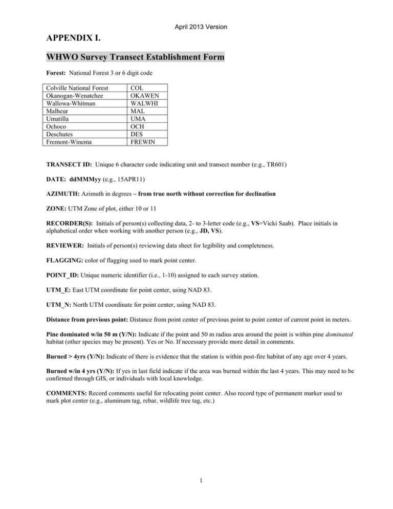
April 2013 Version APPENDIX I. WHWO Survey Transect Establishment Form Forest: National Forest 3 or 6 digit code Colville National Forest Okanogan-Wenatchee Wallowa-Whitman Malheur Umatilla Ochoco Deschutes Fremont-Winema COL OKAWEN WALWHI MAL UMA OCH DES FREWIN TRANSECT ID: Unique 6 character code indicating unit and transect number (e.g., TR601) DATE: ddMMMyy (e.g., 15APR11) AZIMUTH: Azimuth in degrees – from true north without correction for declination ZONE: UTM Zone of plot, either 10 or 11 RECORDER(S): Initials of person(s) collecting data, 2- to 3-letter code (e.g., VS=Vicki Saab). Place initials in alphabetical order when working with another person (e.g., JD, VS). REVIEWER: Initials of person(s) reviewing data sheet for legibility and completeness. FLAGGING: color of flagging used to mark point center. POINT_ID: Unique numeric identifier (i.e., 1-10) assigned to each survey station. UTM_E: East UTM coordinate for point center, using NAD 83. UTM_N: North UTM coordinate for point center, using NAD 83. Distance from previous point: Distance from point center of previous point to point center of current point in meters. Pine dominated w/in 50 m (Y/N): Indicate if the point and 50 m radius area around the point is within pine dominated habitat (other species may be present). Yes or No. If necessary provide more detail in comments. Burned > 4yrs (Y/N): Indicate of there is evidence that the station is within post-fire habitat of any age over 4 years. Burned w/in 4 yrs (Y/N): If yes in last field indicate if the area was burned within the last 4 years. This may need to be confirmed through GIS, or individuals with local knowledge. COMMENTS: Record comments useful for relocating point center. Also record type of permanent marker used to mark plot center (e.g., aluminum tag, rebar, wildlife tree tag, etc.) 1 April 2013 Version WHWO Playback Surveys Form Forest: National Forest 3 or 6 digit code Colville National Forest Okanogan-Wenatchee Wallowa-Whitman Malheur Umatilla Ochoco Deschutes Fremont-Winema COL OKAWEN WALWHI MAL UMA OCH DES FREWIN TRANSECT ID: Unique 6 character code indicating unit and transect number (e.g., TR601) TRANS. LENGTH: Total length of transect in meters. This is usually 2700 m, but may be shorter to fit into available habitat. DATE: ddMMMyy (e.g., 15APR11) UTM_E: East UTM coordinate for point center, using NAD83. UTM_N: North UTM coordinate for point center, using NAD83. UTM_ZONE: UTM Zone of plot, either 10 or 11 VISIT #: 1 or 2 (First or Second) visit of season OBSERVER(S): Initials of person(s) collecting data, 2-letter code (e.g., VS=Vicki Saab). Place initials in alphabetical order when working with another person (e.g., JD, VS). REVIEWER: Initials of person(s) reviewing data sheet for legibility and completeness. POINT ID: Unique numeric identifier (i.e., 1-10) assigned to each survey station. BIRD SPECIES: Four-letter acronym (WHWO or NONE). SEX: Record sex of bird; M= Male, F=Female, or U=unknown DET (Detection): Record whether a bird was first detected aurally or visually. A = auditory; V = visual. DISTANCE: Place an X in the appropriate column to record the bird’s location from the point (0-50m, 50-100, >150m). BEHAVIOR: F=feeding; FY=feeding young; D=drumming; C=calling, E=excavating; P=perched; FL=flying; O=other (elaborate in Comments section) Start Time: military time in hours and minutes (e.g., 1:10 pm is 1310) Wind: 0=no wind; 1=leaves rustling; 2=branches moving; 3=tree trunks moving Weather: 0=clear; 1=30-70% cloud cover, no rain; 2=> 70% cloud cover, no rain; 3=fog; 4=drizzle; 5=rain; 6=snow Temp (oF): Enter air temperature in degrees Fahrenheit COMMENTS: Record comments as necessary to elaborate on behavior of the bird. 2
