Urban Tree Canopy Neighborhood Metrics for New Haven, CT New Haven
advertisement
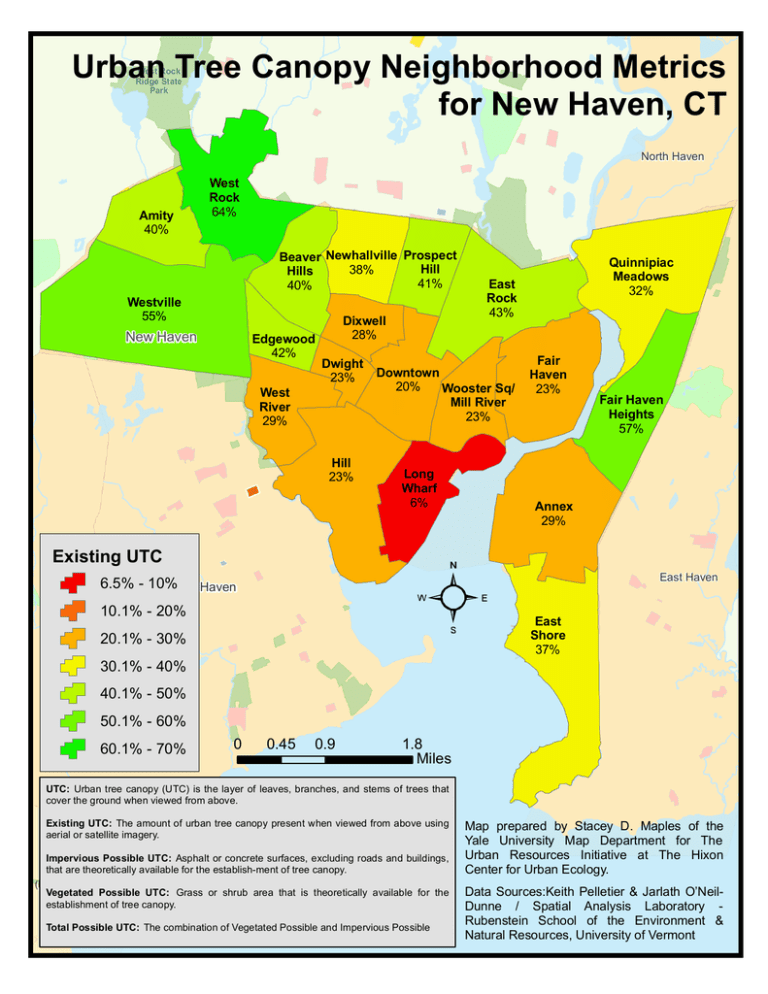
Urban Tree Canopy Neighborhood Metrics for New Haven, CT West Rock Ridge State Park North Haven Amity 40% West Rock 64% Beaver Newhallville Prospect Hill 38% Hills 41% 40% Westville 55% New Haven Edgewood 42% West River 29% Dixwell 28% Dwight 23% Hill 23% East Rock 43% Downtown 20% Wooster Sq/ Mill River 23% Long Wharf 6% Quinnipiac Meadows 32% Fair Haven 23% Annex 29% Existing UTC Orange Fair Haven Heights 57% East Haven 6.5% - 10% West Haven 10.1% - 20% East Shore 37% 20.1% - 30% 30.1% - 40% 40.1% - 50% 50.1% - 60% 60.1% - 70% 0 0.45 0.9 1.8 Miles UTC: Urban tree canopy (UTC) is the layer of leaves, branches, and stems of trees that cover the ground when viewed from above. Existing UTC: The amount of urban tree canopy present when viewed from above using aerial or satellite imagery. Impervious Possible UTC: Asphalt or concrete surfaces, excluding roads and buildings, Milford Milford that city city are theoretically available for the establish-ment of tree canopy. (balance) (balance) Vegetated Possible UTC: Grass or shrub area that is theoretically available for the establishment of tree canopy. Woodmont Woodmont Total Possible UTC: The combination of Vegetated Possible and Impervious Possible Map prepared by Stacey D. Maples of the Yale University Map Department for The Urban Resources Initiative at The Hixon Center for Urban Ecology. Data Sources:Keith Pelletier & Jarlath O’NeilDunne / Spatial Analysis Laboratory Rubenstein School of the Environment & Natural Resources, University of Vermont
