Ko'olaupoko sustainable communities plan

Koolaupoko Sustainable Communities Plan
The Ko’olaupoko Sustainability Plan has been prepared to follow the requirements of the Revised Charter as it prescribes requirements for development plans and is meant for the 2020 planning horizon. This document will serve as the policy guides for public action in support of that goal. The vision statement and supporting provisions are oriented toward maintaining and enhancing the region’s ability to sustain its unique character and lifestyle.
These plans are in response to the specific conditions and community values of each region.
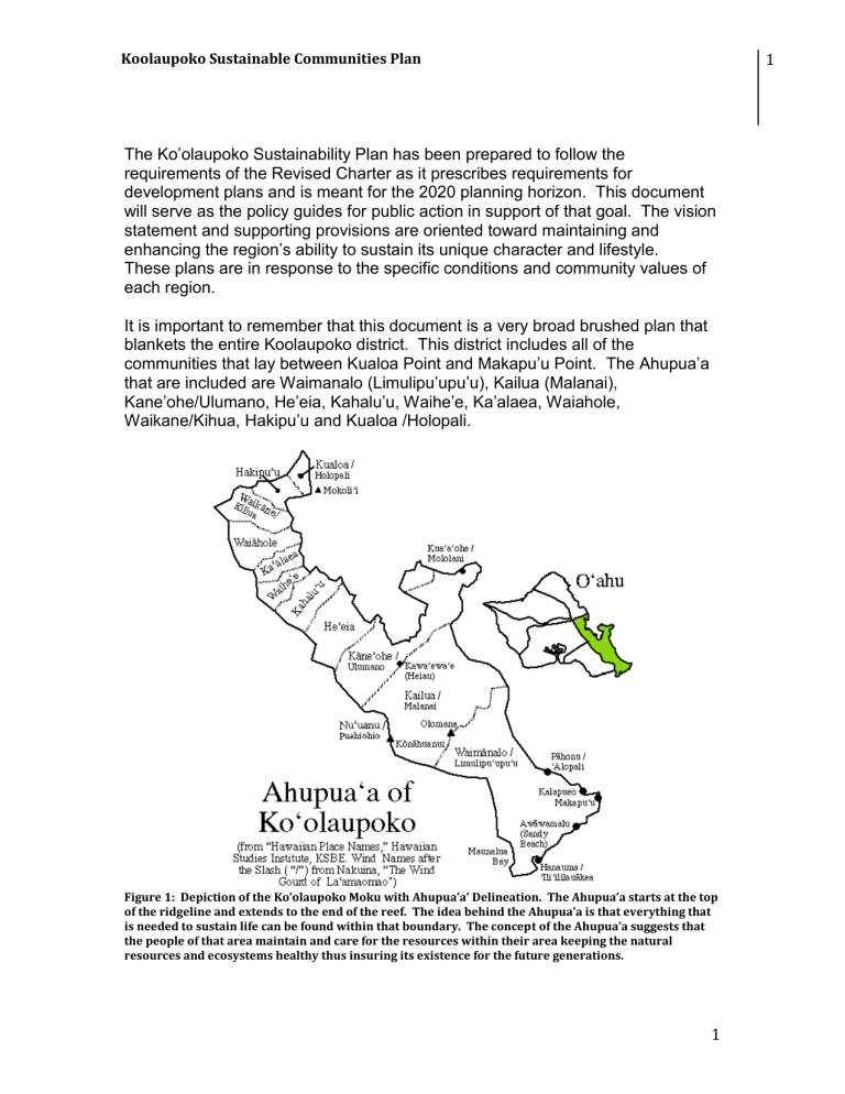
It is important to remember that this document is a very broad brushed plan that blankets the entire Koolaupoko district. This district includes all of the communities that lay between Kualoa Point and Makapu’u Point. The Ahupua’a that are included are Waimanalo (Limulipu’upu’u), Kailua (Malanai),
Kane’ohe/Ulumano, He’eia, Kahalu’u, Waihe’e, Ka’alaea, Waiahole,
Waikane/Kihua, Hakipu’u and Kualoa /Holopali.
1
Figure 1: Depiction of the Ko’olaupoko Moku with Ahupua’a’ Delineation. The Ahupua’a starts at the top of the ridgeline and extends to the end of the reef. The idea behind the Ahupua’a is that everything that is needed to sustain life can be found within that boundary. The concept of the Ahupua’a suggests that the people of that area maintain and care for the resources within their area keeping the natural resources and ecosystems healthy thus insuring its existence for the future generations.
1
Figure 2: Ko’olaupoko land division from: apdl.kcc.hawaii.edu
The plan looks to preserve the natural, scenic, cultural, historic and agricultural resources and to protect the residential environment of its neighborhood. The plan uses three methods:
1. Ahupuaa concept. a.
Definition of ahupua’a i. Pukui and Elbert’s definition
1. Land division usually extending from the uplands to the sea, so called because the boundary was marked by a heap of stones (ahu) surmounted by the image of a pig (pua’a).Pukui and Elbert, Hawaiian Dictionary,
1986 ii.
The ahupua’a has also been described as follows:
1. A principle very largely obtaining in these divisions of territory was that a land should run from the sea to the mountains, thus affording to the chief and his people a fishery residence at the warm seaside, together with the products of the high lands, such as fuel, canoe timber, mountain birds, the right of way of the same and all the varied products of the intermediate land as might be suitable to the soil and climate of the different altitudes from sea soil to mountainside or top.
2. Establishment of boundaries and policies defining the region’s four major land
use patterns and
3. The promotion of open space throughout the region.
Land use planning and management in the city and county of Honolulu
Three Tiered System:
1. General Plan (1977): brief and broad document that states objectives and policies to guide the cities future.
2. Development Plans or Sustainable Communities Plans: a. address 8 geographic regions on the island
1. Primary Urban Center
2. East Honolulu
3.
Central O’ahu
4. Ewa
5. Waianae
6. North Shore
7. Ko’olauloa
2
Koolaupoko Sustainable Communities Plan
8.
Ko’olaupoko (1983)
3.
Land Use Ordinance (Honolulu’s zoning code) and the City’s capital
Improvement Program. Mandated by the City Charter. This is the principle means for implementing the City’s plans. This is meant to carry out eh purposes of the General Plan.
4. Two additional planning mechanisms are not required by the Charter but supplement the three tiers
1. Functional planning Process
2. Special area planning
Chapter 1: Ko’olaupoko’s Role in O’ahu’s Development Pattern
Defines the region’s role and identity within the overall framework of island-wide planning and land use management.
Summary:
Expected to experience essentially no growth over the next 20 years.
Policies limit the potential for expansion of the region’s housing stock, commercial centers and economic activity and are rather focused on maintaining the patterns of development characteristics of its urban fringe and rural areas.
Notes:
3
3
Chapter 2: The Vision for Ko’olaupoko’s future
Describes the vision of the future of the region and lists important elements of that vision.
Summary:
Two principal concepts:
1. Protection of the community’s natural, scenic, cultural, historic and agricultural resources.
2.
Improve and replace as necessary, the region’s aging infrastructure systems. a. Ten key elements of the vision are:
1.
Adapt the concept of “ahupua’a” as a basis for land use and natural resource management.
2. Preserve and promote open space throughout the region.
3. Preserve and promote agricultural uses.
4. Preserve and enhance scenic, recreational and cultural features that define Ko’olaupoko’s sense of place.
5. Emphasize alternatives to the private passenger vehicle as modes for travel.
6. Adapt housing and public works standards to community character and changing needs.
7. Protect residential Neighborhoods.
8. Define and enhance existing commercial and civic districts.
9. Establish Urban Community, Rural Community,
Agriculture and Preservation boundaries.
10. Maintain the predominantly low-rise, low-density, single-family character of the urban fringe and rural communities.
Notes:
4
Koolaupoko Sustainable Communities Plan
Chapter 3: Land Use Policies, Principles and Guidelines
Presents the plan’s policies and provides policy guidance for the region’s various land use elements.
Summary:
General policies, planning principles and guidelines for the major concerns related to land use in Ko’olaupoko. General policies relate to each land use type summarized below:
Open Space Preservation:
-
Protect scenic views; provide recreation and promote access to shoreline and mountain areas.
-
Define the boundaries of communities and provide buffers between agricultural uses, residential neighborhoods and other uses.
-
Create a system of linear greenways along roadways and drainage ways.
-
Prevent development in areas susceptible to landslides and similar hazards.
Island-Based Parks and Recreation:
-
Employ appropriate screening and sitting
-
Ensure environmental compatibility in the design and construction of park facilities.
-
Integrate recreational opportunities with the characteristics of the surrounding community
-
Establish the Kaneohe area a s a top priority for creating new shorelinge access and/or beach parks in Ko’olaupoko.
-
Take steps to make future beach accretion public land in perpetuity.
Community-Based Parks
-
Increase the inventory of community-based parks to provide appropriately located sports and recreation facilities
-
Provide for more intensive use of some existing facilities serving areas in which expansion of site are is constrained
-
Require developers of new residential projects to provide land for open space and recreation purposes, rather than paying the park dedication fee
-
Pursue installation of greenways along streams and drainage channels
Historic and Cultural Resources
Emphasize physical references to Ko’olaupoko’s history and cultural roots
-
Protect existing visual landmarks and support creation of new, culturally appropriate landmarks
-
Preserve significant historic features
-
Retain significant vistas associated with archaeological features
5
5
Agricultural Uses
-
Encourage small-lot agricultural uses and prevent conversion of agricultural lands to non-agricultural uses
-
Adopt development and public works standards that are appropriate and cost effective for rural, agricultural areas
-
Provide supporting infrastructure, services and facilities to foster and sustain agricultural operations.
-
Implement policies and incentives to promote active, long-term agricultural uses,
Residential Uses
-
Modify residential street design to provide emphasis on safe, accessible, convenient and comfortable pedestrian routes, bus stops and bike routes.
-
Maintain the predominantly low-rise, low density, single family character of the region.
-
Protect the integrity of existing residential neighborhoods.
-
Reduce average density guidelines to 2-8 units per acre in urban fringe areas and 0.2 – 4 units per acre in rural areas.
Commercial and Industrial Uses:
-
Identify and define commercial and industrial uses in various categories appropriate to the character and needs of Koolaupoko’s communities, including: o Rural commercial centers o Neighborhood commercial centers o Community commercial centers o Town centers o And areas supporting light and extractive industries
-
Limit the area devoted to commercial and industrial centers to current sites.
-
Expand the use of mixed-use commercial-residential designations and apply mixed-use industrial-commercial designations to existing industrial sites in Kailua and Kaneohe.
-
Rezone the frontage of Hekili street in Kailua to commercial to avoid its use as industrial.
Institutional Uses:
-
Retain the open space character of existing institutional campuses.
-
Site and design campus facilities to respect the scenic context and adjacent residential areas.
Military Uses:
-
Assume MCBH and Bellows AFS will remain under military control.
-
Encourage the State to continue to pursue the release of unused military lands for civilian uses, with special attention to securing permanent civilian
6
Koolaupoko Sustainable Communities Plan
Notes: use of all Bellows shorefront areas and provision of greater civilian shoreline access at MCBH.
7
7
-
Chapter 4: Public Facilities and Infrastructure Policies and
Principles
Presents policies principles and actions needed to support the land use policies of Chapter 3 (Land Use Policies and Principles).
Summary:
General policies and planning principles for the major concerns related to public facilities and infrastructure in Ko’olaupoko.
Transportation Systems:
-
Reduce the reliance on the private passenger vehicle by promoting transportation system management and travel demand management measures for both commuting and local trips.
-
Provide adequate and improved mobility between communities, shopping and recreation centers, especially by enhancing pedestrian, bicycle and transit modes of travel.
-
Maintain adequate person-carrying capacity for peak-period commuting to and from work in the Primary Urban Center.
-
Recommend no new highway widening or interchange construction except to accommodate bikeways.
Water Systems Development:
-
Connect all wastewater produced within the Urban Community and Rural
Community boundary areas to municipal or military sewer service systems.
-
Where feasible, use water recycling as a water conservation measure.
-
Mitigate visual, noise and odor impacts associated with wastewater collection and treatment systems, especially when they are located adjacent to residential designated areas.
Electrical and Communications Systems:
-
Design system elements and incrementally replace facilities such as substations, transmission lines and towers to avoid or mitigate any potential adverse impacts or scenic and natural resource values and residential neighborhoods and to enhance system reliability.
-
Place new utility lines underground.
-
Coordinate improvements with other infrastructure improvement efforts such as road widening.
-
Establish a long range program for systematically relocating existing lines underground.
Solid Waste Handling and Disposal:
-
Continue efforts to establish more efficient waste reduction, diversion and collection systems without adverse impact on residents.
-
Further encourage green waste recycling.
8
Koolaupoko Sustainable Communities Plan
Drainage Systems:
- Promote drainage system desing, which emphasizes control and minimiztion of polluted run-off and the retention of storm water on-site and in wetlands.
9
9
-
Chapter 5: Implementation
Addresses needs for carrying out provisions outlined by the plan.
Page 2-16
In the commercial districts of Waimanalo and Kahalu’u, building scale and design character should be appropriate to a rural area. The intent is to create and retain a “village center” ambiance for these areas, where uses and activities such as farmers’ markets and feed stores are visible presence. Also, provisions should be made for roadside vending for the sale of agricultural products in a manner that is consistent with traffic safety and rural ambience.
Ko’olaupoko Sustainable communities plan
Department of Planning and Permitting, City and County of Honolulu
Jeremy Harris, Mayor August 2000
Page 2-21
The rural community boundary generally circumscribes the sections of
Waimanalo, Kahaluu, Waiahole and Waikane in the state urban district where there are clusters of parcels that are less that two acres in size occupied by dwellings or buildings used for community or commercial purposes other than agriculture. The rural community boundary is intended to include the following:
- Areas in the residential, apartment, commercial, industrial and mixed used districts
- Areas developed for the beneficiaries of the department of Hawaiian home lands
- Public schools serving these communities
- The campus of Hawaii job corps
- Areas not designated as agricultural lands of importance to the state of
Hawaii that are directly adjacent to or surrounded by residential or other urban uses and are suitable for minor infill development for residential, community or commercial purposes
Page 3-7
Waimanalo Bay, from Wailea Point to Makapu’u point
Wide sandy beaches front almost the entire length of Waimanalo Bay. There is a narrower beach and emerging reef rock in the vicinity of Pahonu Pond in the midsection of the Bay shoreline. While Kalanianaole hightway is relatively distant from the shoreline at the northern pint of the beach, physical access is readily available duiring peak recreation periods at Bellows Air Force Station and
10
Koolaupoko Sustainable Communities Plan
Wainmanalo Bay State Recreation Area. In the beachfront residential area of
Waimanalo, there are three pedestrian rights-of-way to the shoreline alone
Laumilo Street. Further South, at Waimanalo Beach Park and Kaiona Beach
Park, the highway is close enough to the shoreline to afford both visual and physical access. In the southernmost stretch, along Kaupo Beach Park and
Makapu’u beach park, visual and physical access to the shoreline is virtually unimpeded. The highway offers dramatic vistas of coastal headlands and cliffs, ocean waters and off-shore islands, and a direct link to the proposed 354-acre scenic shoreline area extending from Makapu’u Point to Koko Head in East
Honolulu.
Page 4-1
Roadway Network
Kalanianaole Highway: Linkes Koolaupoko to communities in East Honolulu and serves as a scenic, secondary route for travel between Kailua/Waimanalo and
Honolulu.
Table 4-1 (page 4-2)
Highway Projects Listed in the O’ahu Regional Transportation Plan, 1995 Update
Widen Kalanianole Highway to four lanes between Waimanalo Beach Park and
Saddle city.
4-2 and 4-3
In workshops for the preparation of this sustainable communities plan and the
Oahu Trans 2K plan, residents of Ko’olaupoko suggested using smaller-capacity buses or vans for short “circulator” routes within the region, especially in the communities of Kailua, Kaneohe and Waimanalo. This service could be used fro shopping trips, connections to express buses and a variety of other purposes, and would support the transportation vision expressed in Chapter 2.2.4 of this
Sustainable Communities Plan.
Table 4-3
Bus route in Ko’olaupoko by category
Route Coverage Frequency of Trips per Day
Express : Provides direct non-stop connections between Koolaupoko and the major activity centers in the urban core of Honolulu.
89 Waimanalo/Kailua to Honolulu 4-(2 each in AM and PM peak
11
11
periods)
Suburban Trunk: provides deirect, multi-stop connections between surburban neighborhoods and activity centers within Koolaupoko
55/65 Circle Island (incl. Kaneohe/Honolulu)
57 Kailua/Waimanalo/Honolulu
8- 30 minute headways 4 am to 12 am
10- 60 min headways 5 am to 11:30 pm
77
Suburban Feeder: provides suburban neighborhoods that are not directly served by trunk routes access to the transit system. Namely to express and truck service routes.
Waimanalo to Kaneohe 50- 60 min headway 6 am to 6 pm
Page 4-4
In Ko’olaupoko, the existing bikeway system consists of discontinuous segments of bike lanes, bike routes and bike paths in Kaneohe, Kailua, Lanikai and
Waimanalo. Significant community interest has been communicated regarding completion of discontinuous segments and expansion of the bikeway system in general. The state’s bikeway master plan proposes substantial additions to
Ko’olaupoko’s bikeway system to create an interconnected grid through the more populated areas and links to East Honolulu via Kalanianaole Highway and to
Koolauloa via Kamehameha highway. The creation of the grid will enhance the potential for bike travel for short commuting and incidental trips. Also, the grid can be expanded by marking bicycle lanes on local streets in residential neighborhoods as part of a “traffic calming” program.
Page 4-8
Potable Water
In Ko’olaupoko, municipal water is supplied primarily by the BWS. In 1990, the region consumed 19.2 mgd of potable water or about 12% of the island wide total. According to the BWS, Ko’olaupoko will need a total of approximately 19.9 mgd of potable water by 2020, and increase of about 0.7 mgd from 1990, in order to accommodate future residential and commercial needs. One of the major sources of future potable water demand in Ko’olaupoko will be the development of residential lots in Waimanalo and Waiahole by the Department of Hawaiian
Home Lands.
Irrigation Waters
12
Koolaupoko Sustainable Communities Plan
In Waimanalo, the state provides water to farmers form the Maunawili ditch, which was built by Waimanalo Sugar Company. Its source is high level water tunnels, springs and streams in Maunawili and Waimanalo Valley. The system delivers about .75 mgd of water.
4-11
Waimanalo Wastewater Service Area
Approximately 65% of residences in the Waimanalo Wastewater Servide Area is served by a centralized wastewater collection, treatment and disposal system.
Wastewater is collected by a network of gravity sewers, and is then treated at the
Waimanalo Wastewater Treatment Plant, which has a 1997 rated average design capacity of .7 mgd and an average flow of about .6 mgd. The wastewater collection syste m, including the Kahawai WWPS is owned by the State of Hawai‘i and operated/maintained by the City and County of Honolulu.
Homes in Waimanalo that are not connected to the public sewers are served by individual wastewater systems, which are generally either cesspools or septic tanks with leaching fields. The “unsewered” areas include certain portions of the low lying coastal areas and all of the inland agricultural lots. In addition, nearly
15% of the homes in the sewered areas are connected to the sewer system and continue to use individual wastewater systems.
In the Waimanalo Wastewater Service Area, there are two key issues of concern
1- Individual Wastewater Systems a. The are water quality and public health concerns associated with the continued use of individual treatment systems (primarily cesspools) in the low-lying coastal areas. Algal blooms have occurred periodically in the nearshore waters of Waimanalo. It is uncertain whether nutrients from individual wastewater systems, stormwater runoff, and/or treatment plant effluent are promoting such algal bloom.
2- Waimanalo Wastewater Treatment Plant (WWTP) a. The plant has a record of unstable performance and periodic effluent quality violations. Treated effluent is currently disposed through the use of subsurface injection wells. The existing capacity of the disposal wells is marginally adequate due to the clogging of the wells from excessive suspended solids in the effluent. These problems are believed to stem from increased loading on the plant and the use of outdated liquid stream treatment technology. The capacity of the WWTP needs to be increased to serve future needs.
Also, the service are should be expanded to cover properties where
13
13
the individual wastewater systems are resulting in environmental and health hazards. b. To address these concerns, the average desing capacity of the
WWTP will be increased from .7 mgd to 1.1 mgd. The expansion will include a new secondary biological treatment process, an effluent filtration system, additional injection wells, new sludge thickening facilities, an upgraded electrical system, and added personnel and maintenance facilities. There will also be an ultraviolet disinfection system and effluent pumping facilities to allow the use of recycled water for irrigating selected agricultural lots and the
Olomana Golf links.
Page 4-19
School and Library features
Waimanalo elementary and intermediate
Enrollment: 649
Capacity: 871
Under/Over: 222
The library is incorporated into the elementary and intermediate school.
Waimanalo has a fire station
There is a mobile satellite city hall in Waimanalo that operates once a week at the Waimanalo Town Center.
Page 4-23
Planning Principles and Guidelines
General:
- to enhance the natural environment in and around all communities within
Ko’olaupoko, utility wires should be placed underground henceforth and existing overhead wires relocated underground
- Design traffic control boxes to be screened to reduce visual impacts
- Require and enforce requirements for shade trees in all parking lots
- Include shade trees as desirable street trees
- Keep street and highway signs to a minimum and then only for traffic control and direction (not to include permanent message boards)
- Incorporated medial planting strips in roadways wherever practical
- Continue to prohibit “billboards” and other outdoor advertising devices
- Supply litter containers for the street-outlet end of public beach right-ofways
14
Koolaupoko Sustainable Communities Plan
-
Encourage each individual community to formulate desired “design” guidelines for public and private projects.
Waimanalo and Kahalu’u
- Refrain form requiring wide streets with curbs and concrete gutters in rural areas
- Refrain from requiring sidewalks in rural areas
- Refrain from installing streetlights in rural areas unless requested by the community
- Develop rural community standards compatible with these less intensively developed residential communities
Special Area Plans
Special Area Plans can be used to guide the land use development and infrastructure investment in SPECIAL DISTRICTS (distinct historic or design character or significant public views), REDEVELOPMENT DISTRICTS
(revitalization or redevelopment) or RESOURCE AREAS (natural or cultural resource values.
At this juncture the only verbiage in the current sustainable communities plan is as follows verbatim:
Waimanalo Village Center.
A plan to improve pedestrian circulation, public transit service, landscaping and public open spaces, street fixtures and signage, and building appearance in the rural commercial/civil district and to locate a private base yard if appropriate.
Funtional Planning:
Zone Changes:
A zone change shall be considered significant if it involves at least one of the following:
1. Any change in zoning of 10 or more acres of land to any zoning district or combination of zoning districts, excluding preservation or agriculture zoning districts.
2. Any change in zoning of more than 5 acres to an apartment, resort, commercial, industrial or mixed use zoning district.
3. Any development which would have a major social, environmental, or policy impact or major cumulative impacts due to a series of applications in the same area.
15
15
Projects that do not involve significant zone changes will be reviewed by DPP for conformance with the policies, principles, development priorities and guidelines of the Koolaupoko Sustainable Communities Plan and the population policies of the General Plan. Those projects requiring environmental assessment shall follow the provisions on Hawai‘i Revised Statutes, Chapter 343. Also for any specific rezoining application for a change to BMX, the applicant should prepare an analysis of the projected population impacts of the change to verify that such impacts will not exceed the population policies of the General Plan as they apply to Koolaupoko.
Projects involving significant zone changes will require an Environmental
Assessment. This submitted to the DPP for review prior to initiation of the Zone
Change Application.
16


