annexure - Delhi Development Authority
advertisement
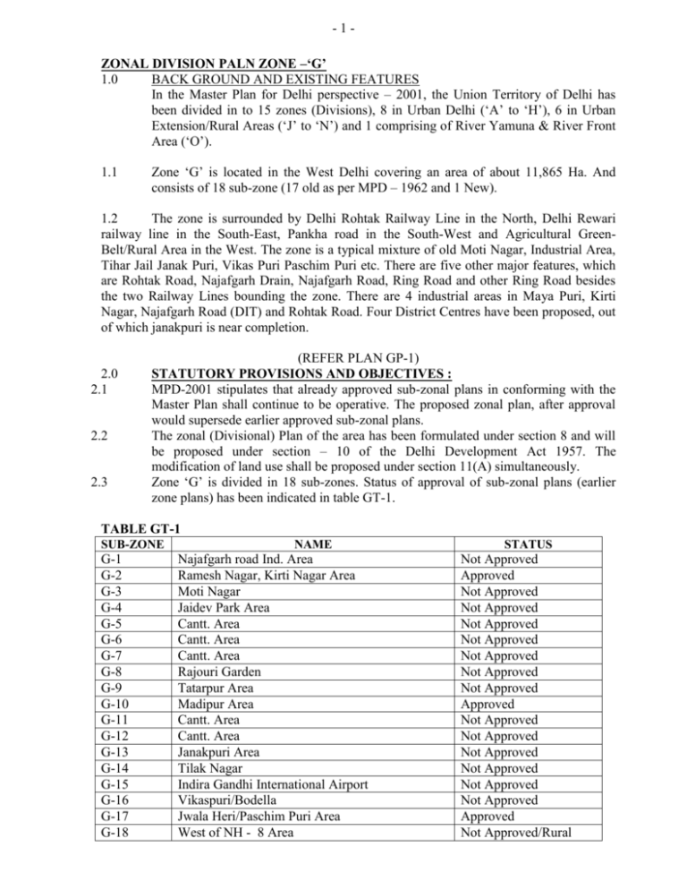
-1ZONAL DIVISION PALN ZONE –‘G’ 1.0 BACK GROUND AND EXISTING FEATURES In the Master Plan for Delhi perspective – 2001, the Union Territory of Delhi has been divided in to 15 zones (Divisions), 8 in Urban Delhi (‘A’ to ‘H’), 6 in Urban Extension/Rural Areas (‘J’ to ‘N’) and 1 comprising of River Yamuna & River Front Area (‘O’). 1.1 Zone ‘G’ is located in the West Delhi covering an area of about 11,865 Ha. And consists of 18 sub-zone (17 old as per MPD – 1962 and 1 New). 1.2 The zone is surrounded by Delhi Rohtak Railway Line in the North, Delhi Rewari railway line in the South-East, Pankha road in the South-West and Agricultural GreenBelt/Rural Area in the West. The zone is a typical mixture of old Moti Nagar, Industrial Area, Tihar Jail Janak Puri, Vikas Puri Paschim Puri etc. There are five other major features, which are Rohtak Road, Najafgarh Drain, Najafgarh Road, Ring Road and other Ring Road besides the two Railway Lines bounding the zone. There are 4 industrial areas in Maya Puri, Kirti Nagar, Najafgarh Road (DIT) and Rohtak Road. Four District Centres have been proposed, out of which janakpuri is near completion. 2.0 2.1 2.2 2.3 (REFER PLAN GP-1) STATUTORY PROVISIONS AND OBJECTIVES : MPD-2001 stipulates that already approved sub-zonal plans in conforming with the Master Plan shall continue to be operative. The proposed zonal plan, after approval would supersede earlier approved sub-zonal plans. The zonal (Divisional) Plan of the area has been formulated under section 8 and will be proposed under section – 10 of the Delhi Development Act 1957. The modification of land use shall be proposed under section 11(A) simultaneously. Zone ‘G’ is divided in 18 sub-zones. Status of approval of sub-zonal plans (earlier zone plans) has been indicated in table GT-1. TABLE GT-1 SUB-ZONE G-1 G-2 G-3 G-4 G-5 G-6 G-7 G-8 G-9 G-10 G-11 G-12 G-13 G-14 G-15 G-16 G-17 G-18 NAME Najafgarh road Ind. Area Ramesh Nagar, Kirti Nagar Area Moti Nagar Jaidev Park Area Cantt. Area Cantt. Area Cantt. Area Rajouri Garden Tatarpur Area Madipur Area Cantt. Area Cantt. Area Janakpuri Area Tilak Nagar Indira Gandhi International Airport Vikaspuri/Bodella Jwala Heri/Paschim Puri Area West of NH - 8 Area STATUS Not Approved Approved Not Approved Not Approved Not Approved Not Approved Not Approved Not Approved Not Approved Approved Not Approved Not Approved Not Approved Not Approved Not Approved Not Approved Approved Not Approved/Rural -2OBSERVATIONS i. ii. iii. iv. Approved Not Approved Cantt./Airport Rural 3.0 MASTER PLAN STIPULATIONS : 3.1 MPD – 2001 stipulates that the sub-zonal plan for government ‘Undermined’ use will be prepared by the Cantt. Board. These are G-5 to 7, 11 & 12 (5 Nos.) 3.2 The new sub-zone G-18 added in MPD – 2001 is predominantly Rural use Zone and the stipulated 2 Km, green belt may be followed along the National Territory Boundary. 4.0 POPULATION AND EMPLOYMENT : 4.1 i. ii iii iv v 4.2 4.3 3 8 6 1 Population as per MPD -62 i.e. Delhi Urban Master Plan Population as per census 1981 Population as per census 1991 Planned Population year 2001 Holding capacity as envisaged In MPD – 2001 - 8,03,175 Persons - 8,68,277 Persons - 12,29,607 Persons - 13,69,143 Persons - 14,89,570 Persons (For sub-zone vise projected population refer Annexure – GA-1 Page 17) As per MPD – 2001 work studies zone ‘G’ has been categorized under Marginal Potential area with respect to the utilization of available holding capacity of 2001 population. Based on the various activities a total of 32 employment centers have been identified with estimated work force of about 3.85 lacs (Annexure – GA-II page 18) INDUSTRIAL SCHEMES. a) b) c) d) Mayapuri kirti Nagar Najafgarh Road Rohtak Road - 32,470 Workers - 26,700 Workers - 45,000 Workers - 38,100 Workers COMMERCIAL a) b) c) d) Distt. Center Raja Garden Distt. Center Janak Puri Distt. Center Paschim Vihar Distt. Center Rohtak Road - 18,000 Workers - 12,000 Workers - 10,800 Workers - 23,300 Workers -35.0 IMPORTANT DEVELOPMET FEATURES As per MPD – 2001 zone ‘G’ can be divided into the following parts for the purpose of development / redevelopment : i. Rural Area / Statutory Green Belt ii. Cantonment Area iii. Airport Area iv. Other important specific use a) Tihar Jail b) Industrial belts 5.1 RURAL AREA / STATUTORY GREEN BELT : The sub-zone G-18 which was earlier in MPD – 62 was not a part of ‘G’ division now forms a part of the Rural belt of ‘G’ Division. The area is bounded by Rewari Railway Line in the West. Airport on the North, NH-8 on the East and U.T. boundary line on the South. As per the provision in MPD – 2001 it would be appropriate to establish a green belt along U.T. boundary upto a depth of about 2 km. 5.2 CANTONMENT AREA : 5.3 Five sub-zones viz G-5, 6,7,11 and 12 of the ‘G’ Division from a part of the cantonment Area. The development of these sub-zones will be taken up as the provision of MPD – 2001. AIRPORT AREA : The sub-zone G-15 of this zone comprising of Airport area and is bounded by Rewari Railway Line on the West, Cantt. Area on the north, NH-8 in the East and new Rural use sub-zone G-18 on its South. An International Airport and National Airport are located within this area. 5.4 URBAN VILLAGES In all a total of 26 villages are falling in this zone. Six out of these are located in subzone G-18 which continue to be predominantly a Rural use zone. The remaining 20 (G – 8) are located in the Urban area including Cantonment. 5.5 TIHAR JAIL This Central jail is located in sub-zone G-13 of the division and is important feature of the zone. This is a high security central jail and is the only of its kind not only in Delhi, but also in the entire Northern Region. 5.6 INDUTRIAL BELTS : The major extensive industrial areas located in this zone are along Najafgarh road and Rohtak Road as well as in Mayapuri and Kirti Nagar. These are the major employment centres of the division employment around 2/5th of the total work force of the division. -46.0 ZONAL LEVEL PLANS In consistence with MPD – 2001 frame work the provision and proposal of the Master Plan have been detailed out particularly with reference to various use zone, circulation public and semi-public facilities, infrastructure and recreational etc. 6.1 6.1.1 S.No. 1. 2. 3. 4. 5. 6. 7. 8. 9. LAND USE PLANS Based on the existing land analysis the land use analysis sub-zonal level Annexure GA-3, Page No. 20 the proposed land use analysis at the zonal level is given in GT-2. The facilities proposed in various sub-zones have been detailed out in the land use plan. LAND USE ANALYSIS OF ZONAL PLAN LEVEL ZONE’G’ TABLE GT - 2 (Sub-zones G-1 to 4,8 to 10,13 & 14, 16 & 17 – Total 11 Nos.)* Land–use analysis Residential Commercial Manufacturing Recreational Transportation Utility Government Public/ semi-public Vacant TOTAL Existing Proposed Area in Hec. % age Area in Hec. % age 3149.56 141.29 374.47 586.80 593.00 82.70 75.81 325.89 126.80 5456.32 57.72 2.58 6.86 10.75 10.87 1.53 1.39 5.98 2.32 100.00 3165.36 178.05 389.97 595.10 596.63 0.10 75.81 362.30 58.02 3.26 7.15 10.90 10.93 1.70 1.39 6.65 5456.32 100.00 * Remaining sub-zones the position is 5 Nos. falls in Govt use undetermined (Cantt. Area G-5 to 7 and 1 & 12) , 1 No. Airport (G-15) and 1 No. Rural Area (G18) and have not been accounted in his table. Details refer Annexure – GA-3 & 4 at page 20 & 21 of the report. 6.1.2 POLLUTING INDUSTRIES : According to 1985 list of 1476 industrial units based on rapid survey of Delhi Admn. Only 298 such industries units (Annexure GA-6 at page 22) are shown in zone-‘G’ however, 104 units of the list are located out side the zone. 168 Nos. of these are located in planned industrial schemes and 26 units are located in other than industrial areas. -5Break-up of polluting industries as per the list supplied by Delhi Admn. Based on 1985 survey: i. ii. iii. iv. v. 6.1.3 Total No. As per the list Industries located outside Zone – ‘G’ Industries falling in zone – ‘G’ Located planned industrial schemes Located /isolated in other than industrial areas - 298 - 104 - 194 - 163 - 26 HEAVY AND LARGE SCALE INDUSTRIES Out of the list of polluting Industries, 3 units have been identified as large scale industries. TABLE GT – 3 S.No. 1. 2. 3. Name of unit and Address M/s. Metal forging (P) Ltd., B-1, Mayapuri Industrial Area Phase – 1 M/s. Hindustan Insecticides Ltd., Guru Govind Singh Marg, New Delhi M/s. Indian Oxygen Ltd. Shivaji Marg., 66, New Delhi Area in Hec. 2.0 5.0 1.4 These heavy and large scale industries shall shift to DMA and NCR. Keeping in view the National Capital Plan, National Industrial Policy of Govt. of India. The land thus become available on account of shifting would used for making up the deficiency in facilities as per the requirement of the zone / sub-zone. It is recommended that the owner will be as average surrender part of the total land to be used for meeting the deficiency and the remaining to be for his gross use as prescribed land use in the Master Plan /Zonal Plan or as per Policy. 6.1.4 NOXIOUS AND HAZARDOUS INDUSTRIES : Delhi Admn. has identified 10 such industrial units in Nov. 1992, 8 of these are located in zone ‘G’ (Annexure – GA -7 at page 40) vacated and of industries will be utilized as per orders of the Hon’ble Court. 6.2 TRANSPORT NETWORK: 6.2.1 BACKGROUND NOTE The zone is well connected by roads and rail lines. The important roads of the zones are Rohtak Road/NH-10, Ring Road, Outer Ring Road, Najafgarh Road, Jail Road, Pankha Road etc. NH-8 is located passing through the South Extension part of the zone, Express way proposed to link Mathura Road with GT Road will also pass through the sub-zone G-18. The Railway lines are broad gauge to Rohtak Ring Railway line and the Metergauge to Rewari/Jaipur line (is also being upgraded to -6broad gauge). The circulation pattern in the area of sub-zone G-18 falling towards South east of Rewari Railway line has been indicated in the Plan GP-6. MAJOR ROAD 1. Rohtak road 2. NH-10/NH-8 3. Ring Road 4. Outer Ring Road 5. Jail Road 6. Najafgarh Road 7. Pankha Road 8. Express-way (G-18) RAILWAY LINES Rohtak Railway Lines Ring Railway Rewari / Jaipur 6.2.2 EXISTING /PROPOSESD GRADE SEPARATORS AND EXISTING BRIDGES: It is proposed in the MPD – 2001, that major road intersections may be provided with grade separators to ease out the traffic. The emphasis has also been given to grade separation for pedestrian and cyclist wherever required. In the zone 6 Nos. grade separators exist. 1. 2. 3. 4. 5. 6. Patel Nagar (R.O.B) Mayapuri R.O.B. (Ring Road) Delhi cantt. R.O.B. Near Punjabi Bagh (Transport Centre) R.O.B. Mangolpuri R.O.B. (Outer Ring Road) Daya Basti/Zakhira R.U.B. And five existing bridges on Najafgarh drain are at Khayala, Raghubir Nagar, Basai Darapur, Patel road Extn. and the other one is near East Punjabi Bagh Club, Rohtak road. Looking in to the overall future development of National capital Union Territory of Delhi, and specifically Western part of Delhi, it is proposed to have 8 nos. more grade separators to improve the traffic flow. These are proposed in the following locations : 1. Punjabi Bagh (On Ring Road and Rohtak Road) Transport center 2. Peera Garhi Chowk (on Outer Ring Road and Rohtak Road) 3. Lajwanti Garden (On Jail Road and Mayapuri Road) 4. Raja Garden (On Ring Road and Najafgarh Road) 5. Pankha Road R.O.B. on Delhi Rewari Railway Line 6. Tilak Nagar Grade Separator 7. Grade Separators (Distt. Centre Janakpuri) 8. Grade Searators Raja Garden (on Najafgarh Road and Ring Road) The existing / proposed grade separators and bridges are shown on the plan. However, out of these the construction of the grade separator in the junction of Inner Ring and Shivaji Marg near Raja Garden is under construction. -76.2.3 IMPOORTANT INTERSECTIONS : There are 7 Nos new road intersections in this zone. The details have to be worked out for the individual intersections as per the requirement of the area and adequate pedestrian, cycle tracks may be incorporated to these incorporated to these intersections which will meet the future demand and safety to the commuters. 6.2.4 MRTS ROUTE MRTS Route has been incorporated in the zonal plan. 6.2.5 BUS DEPOT In the MPD – 2001, it is envisaged to have two Bus depot for a population of 5 lacs. Accordingly, the required number of Bus depot 5 for a population of 12 lacs approx. At present, there are 5nos. of Bus Depot already existing in this zone. Therefore, as such there is no deficiency in providing the Bus depot. 6.2.6 BUS TERMINAL It is envisaged in the MPD – 2001, that one Bus terminal be provided for 1 lacs population. Hence the required number of Bus Terminals for the entire zone is 13 against which the following are existing in this zone :1. Keshopur 2. Uttam Nagar 3. ITI Hari Nagar 4. Tagore Garden 5. Raja Garden 6. Punjabi Bagh 7. Moti Nagar One Bus Terminal site is proposed in G-10 area in the proposed Community centre. This makes a total of 8 Nos. Bus terminal sites in this zone against 18 Nos. BUS DEPOT ZONE – ‘G’ Table : GT – 4 & 5 S.No. Description Reqd. as per Position in zonal Net deficiency /Remarks MPD - 2001 plan Existing Proposed Total Surplus 1. 2. 6.2.7 Bus Depots Bus Terminals 5 13 5 7 … 1 5 8 Nil 5 CYCLE TRACK In the MPD – 2001 two cycle tracks have been provided namely along the Najafgarh drain and cutting across the sub-zone G-2&3. However, before implementation the detail feasibility of providing the cycle tracks will be worked out and accordingly it will be modified and implemented as per site condition. -86.2.8 RAILWAY STATIONS/YARDS Presently there are two railway Stations/ yards existing in this zone. These are: 1. Kirti Nagar 2. Delhi Cantt. However, 4 other railway stations located exactly on the periphery of this zone also take care the needs of this zone. These are: 1. 2. 3. 4. Mangol puri Shakur Pur Daya Basti Patel Nagar All these railway stations are shown in the zonal development plan. 6.2.9 NIGHT PARKING : The parking of buses during night time be restricted to approve general parking area of District Centres, Community Centres, local Shopping centres, Facility Centres, service centres etc. and policy be framed by concerned lands deptt. For enforcement agencies. 6.3 GREEN AREAS The total green area proposed at zonal level works out to about 595.10 Hec., out of which 519.70 Hec. Is under district parks, stadium and children parks and the remaining 75.4 Hec. at zonal level which is mainly located in the residential areas. 6.3.1 DISTRICT PARKS AND SPORTS STADIUM Besides retaining the Master Plan green areas, a number of sports station and children parks have been proposed in conformity with the recommendations of MPD – 2001, including existing facilities in sub-zone G-10, one children park and a sports stadium have been proposed in sub-zone G-17, one sport stadium has already been built by DDA and the other has been planned near Nangloi mainly for catering the rural population. One sport complex has already been built by DDA in Hari Nagar and it is proposed to develop another one in the green area to the south of Maya Puri Indl. Area Ph.-II. A number of schemes which are either existing or have been proposed to land use from ‘Recreational’ use. It is proposed to compensate equivalent area in the urban extensions of sub-zone G-17. 6.3.2 NEIGHBOURHOOD PARKS. The large green areas in the neighborhood have been considered for inclusion in the NHP which work out to apprx. 75.4 Hec. and are distributed in most of the residential colonies of the zone. These calculations for the green areas have not been done for sub-zones falling in the Cantt.Area, Airport and rural sub-zone G-18. -9Sub- Zones District Parks G-1 G-2 G-3 G-4 G-8 G-9 G-10 G-13 G-14 G-16 G-17 3.50 GREEN AREAS Area in Hac. Play Children Park NHP Ground/ Station 4.00 101.70 29.50 72.20 30.10 36.00 32.80 158.00 467.70 4.0 4.0 Table GT-6 Total Remarks 7.75 24.00 15.0 3.50 2.50 4.75 6.00 127.20 30.50 104.60 42.50 36.00 40.55 197.00 75.4 48.0 595.10 2.50 0.75 6.00 17.50 1.0 3.40 12.50 8.0 25.20 6.4 PHYSICAL INFRASTRUCTURE / UTILITIES 6.4.1 WATER SUPPLY Based on the norms Master Plan – 2001 the total requirement of water supply for the entire zone excluding cantonment area and the area out side urban limits will be around 98 MGD (Million Gallons per day) with the break up as follows MGD i Domestic @ 225 litters per capacity per day - 60.8 ii Industrial, Commercial and community @ 4500 liters/hect./day) i.e. @ 17 liters per capita per day - 12.8 iii Fire Protection @ 1% of total demand i.e. @ 4 litres per capita per day - 1.1 Garden @ 67,0001 es/hect. Day i.e. 35 liters/ capita/day - 9.5 iv v For floating population and special uses like emphasis, big hotels etc. @ 52 liters/capita/day - 14.4 98.6 6.4.2 SEWERAGE (I) Assuring that 80% of the total water requirement will go into the sewerage, the total sewerage for the entire zone would be around 79.MGD as per the (II) - 10 details given in the table No. GP-17. In the zone a large sewerage treatment plant Keshopur is already existing. The existing capacity of the plant is 32 MGD, which is proposed to be augmented to 170 MGD by the year 2001. COVERING OF DRAIN : Najafgarh drain from Patel Nagar extension to Rohtak Road is covered and available area is utilized for circulation and land scaping subject to the decision of the committee constituted by L.G. for covering of major drains. SEWERAGE & SOLID WASTE TABLE GT-17 COMMUNITY 1. 2. 3. & 4. 5. 6. 7. & 8. 9. 10. 11,12 & 13 TOTAL SEWERAGE (MGD) 4.5 8.3 11.6 6.9 6.0 12.5 10.4 5.6 12.9 78.70 MGD SOLID WASTE (TONNES) 42.00 78.10 108.40 64.40 55.70 117.00 97.50 52.40 121.00 737.40 TONNES 6.4.3 POWER Keeping in view the norms of Master Plan 2001 the total power requirement for the entire zone would be of the order of around 383 MW. The location of existing substations including 220 KV sub-station passing through the zone are illustrated in detail in the Physical & Social Infrastructure, of the zone. 6.4.4 SOLID WASTE Keeping in view the norms of 0.6 per kg. Per capita per day as prescribed in the Master Plan the total solid waste disposal of the entire zone works out to around 737 Tonnes per day as detailed out in the table No. GT-17. A large part of this solid waste could be accommodated in the sanitary refill sites identified as per MPD – 2001 and other areas. 7.0 PUBLIC AND SEMI PUBLIC FACILITIES & UTILITIES 7.1 COMMUNITY STRUCTURE In the zone the population of around 14 lacs is proposed to be identified into 13 communities as described below. - 11 PROPOSED COMMUNITY STRUCTURE IN ZONE ‘G’ (Table GT-7) Community No. 1. 2. 3 & 4. 5. 6. 7&8 9 10 11 & 12 13 13 Nos. 7.2 EDUCATION 7.2.1 COLLEGES Sub-zones 1&4 2&3 8 9 10 13 14 16 17 5,6,7,11,12,15, & 18 18 Population 40,000+29,929 = 69,929 70,075+60,000 = 1,30,075 1,80,627 1,07,393 92,910 1,96,475 1,62,414 87,422 2,01,680 1,40,000 13,69,143 In the zone presently 6 colleges/ITI are already functioning against the total requirement of 13 colleges as per the norms of MPD – 2001. New colleges have been proposed in the zone as given in Table GT-7, with this the deficiency of colleges in the zone will come down to 3 colleges. TABLES GT – 8 Community Required No. as per MPD2001 1 1 2 1 3&4 2 5 1 6 1 7 8 2 9 2 10 1 11 & 12 2 TOTAL 13 7.2.2 Position in Zonal Plan Net deficiency Remarks (-)/surplus(+) Exist. Prop. zonal 1 1 1 1 1 1 6 1 1 1 1 4 2 1 2 1 1 2 1 10 -1 -1 -1 -3 SR. SECONDARY SCHOOL At present there are 92 Sr. Secondary Schools functioning in the zone while many of the Senior Secondary School of Delhi Admn. Are already running in the double shifts. New Sr. Secondary Schools sites have been proposed in the zonal plan. - 12 (TABLE GT -9) Community Required as No. per MPD2001 1 9 2 17 3&4 24 5 14 6 12 7&8 26 9 22 10 11 11 & 12 27 TOTAL 162 7.3.1 Position in Zonal Plan Net deficiency Remarks (-)/surplus(+) Exist. Prop. Total 6 8 19 5 5 16 6 9 19 92 2 3 1 2 1 1 11 6 11 20 7 6 16 7 9 19 103 -1 -6 -4 -7 -6 -10 -15 -2 -8 -52 HOSPITALS: As per MPD – 2001 the hospitals have been broadly categorised as general Hospital and intermediate hospitals. As against the requirement of 5 general hospitals, presently only 3 general hospitals are existing in the zone. Similarly as against the requirement of 24 intermediate hospitals only 6 intermediate hospitals are existing in the zone as given in table GT-10. (TABLE GT -10) Community Required as Position in Zonal Plan Net deficiency Remarks No. per MPD- EXIST. PROD. TOTAL (-)/surplus(+) 2001 Inter Gen. Inter Gen. Inter. Gen. Inter Gen. Inter Gen. 1. 1 -1 2. 2 2 1 1 -1 -2 3&4 4 1 1 +1 -4 5. 2 -2 6. 2 1 1 2 7&8 2 4 1 1 1 1 -1 -3 9. 3 1 1 +1 -3 10. 2 -2 11 & 12. 1 4 1 4 1 4 Total 5 24 2 2 3 5 5 7 -17 7.4 COMMERCIAL In the Zone 4 District centres and Sub. Distt. Centers at Hari Nagar are already existing as against the total requirement of only 2 to 3 district centres as per the norms of MPD-2021: 7 additional community centers and a few local shopping centres have been proposed in the zone as detailed out in TABLE GT -12 to 14. Two warehousing and depots at Kirti Nagar and Mayapuri are already existing in the zone in addition to one transport centre functioning at Rohtak Road. One Fruit and vegetable market of DAMB is covering an area of around 6 hect. is also functioning in the zone. - 13 DISTRICT CENTRES Description Total TABLE GT-12 Required Position in Zonal Plan as per Exist. Prop. MPD2001 3 4+1 (SDC) - Net deficiency Remarks (-)/surplus(+) Total 5 +2 LOCAL SHOPPING TABLE GT-13 Community Required Position in Zonal Plan No. as per Exist. Prop. MPD2001 1. 2. 3&4 5. 6. 7&8 9. 10. 11 & 12. 4 8 12 7 6 13 11 5 13 1 11 1 2 3 6 5 17 Net deficiency Remarks (-)/surplus(+) Total - 1 11 1 2 3 6 5 17 -3 3 -11 -5 -3 -7 -11 +4 COMMUNITY CENTRE TABLE GT-14 Community Required Position in Zonal Plan No. as per MPDExist. Prop. Total 2001 1 1 2 2 2 1 3 3 3&4 2 6 6 5 1 1 1 6 1 1 1 7&8 2 3 3 9 2 1 2 3 10 1 1 2 3 11 & 12 2 1 2 3 Total 13 18 7 25 7.5 Net deficiency (-) surplus(+) Remarks +1 +2 +4 -1 +1 +1 +2 +1 +12 PETROL PUMPS : As against the requirement of 27 petrol pumps as per MPD-2001, 24 sites are already existing. In addition 17 sites has been proposed, which are mainly to be located in District/Community Centers. - 14 7.6 L.P.G. GAS GODOWNS As against 30 sites of LPG Godowns as per MPD-2001, 47 sites are already existing. Accordingly no additional sites have been proposed. TABLE GT – 11 S.No. Description Required as Position in the Zonal Plan per MPDExis. Prop. Total 2001 Net deficiency (-) /Surplus(+) 1. Petrol 27 Pumps L.P.G. Gas 30 Godown 2. 7.7 24 17 41 +14 47 - 47 +17 OTHER COMMUNITY FACILITIES A number of public and semi public facilities have been augmented in the zone mainly in 14 facility centers and 5 service centres as per the details in table GT-15. In addition as per the provisions of MPD-2001, the land becoming available on account of shifting of existing hazardous and noxious industrial units would be utilised for the making up the deficiency as per the needs of the community on the norms specified in MPD-2001. OTHER COMMUNITY FACILITIES : TABLE GT-15 S.No. 1. Facility services Area in Hect. centre No. FC-34 11.65 2. FC-35 3. FC-36 4. FC-37 5. FC-38 6. FC-39 7. FC-40 Facility proposed General Hospital, Intermediate Hospital ‘A’ Intermediate Hospital ‘B’ Nursing Home, Police Station, Fire Station, Head Post Office. 6.00 (Madipur) Intermediate Hospital ‘A, Intermediate Hospital ‘B’, Police station, Nursing Home (3 Nos.) 4.00 (Madipur) Intermediate Hospital ‘A’, Nursing Home (4 Nos,) 4.00 (On Rohtak Rd) Intermediate Hospital ‘A’, Nursing Home (3 Nos,) 5.00 (G-17 along Intermediate Hospital ‘A’, Intermediate Najafgarh drain) Hospital ‘B’, Police station. 2.40 (Golden Park, Police Station, Forensic Science Laboratory, Rohtak Road) Head Post Office. 9.00 (Karam Pura) College, ITI Polytechnic, Fire Station, Not feasible due to existing HSS & IND. Area :The land utilization layout plan will be formulated as per orders of the Honorable Supreme Court relating to the industries. - 15 8. FC-41 9. FC-42 10. FC-43 11. FC-44 12. FC-45 13. 14. FC-46 FC-47 18.50 Colony) (Shivaji Social Cultural, College telephones Exchange Deptt. of Telegraph, Police station, General Hospital, Fire Station. 15.50 (Tatarpur) College ITI-Technical School, Central Hospital, Intermediate Hospital ‘B’, Nursing Home (2 Nos.) 13.20 Police Station, Fire Station, University (Khayala) Campus, Intermediate Hospital ‘B’ (2 Nos), Telephone Office, Head Post Office. 6.00 (Sant Nagar College intermediate Hospital ‘B’ Nursing outer Ring Road) Home (2 Nos) 6.95 College Police Station, Fire Station, Nursing (Janakpuri C-Block) Home (2 Nos) 4.00 College (Behind Rajouri Garden) 3.20 Police Station, Fire Station, Nursing Home (3 Nos.) SERVICE CENTRES 1. 2. 3. 4. 5. 8.0 S-13 S-14 S-15 S-16 S-17 1.08 5.00 7.55 16.00 7.00 TABLE GT-16 2 No. of L.P.G. Godowns (G-13 near Tihar Jail) 4 No. of L.P.G. Godowns (G-3 Basai Dara Pur) 4 No. of L.P.G. Godowns (Os Jail Road, Lajwanti Garden) 4 No. of L.P.G. Godowns (Behind STP Keshopuram) 4 No. of L.P.G. Godowns (Behind Jawala Heri, Resettlement Colony) MIXED LAND USE According to the provision in MPD-2001 clause-10 of “non-residential activities premises” mixed use could be permitted on all roads having 13.5 Mtr. R/W and above, taking into consideration the community needs, provision for Traffic, parking generated and in addition to its environmental impact. The MCD has forwarded a table of 18 streets (Annexure GA-5 at page No. 19) these have further been studied and it is observed that non-residential activity could be permitted along with the following 6 roads/streets as per the conditions specified in MPD-2001. PROPOSED MIXED LAND – USE STREETS TABLE GT-18 S.No. 1. 2. 3. 4. 5. 6. Name of road/location Main Najafgarh Road from Laxman Sylvania, New Moti Nagar Chowk to Outer Ring Road Crossing i.e. Ganesh Nagar. Between Kirti Nagar Maya Puri Chowk to Kirti Nagar Patel Nagar chowk Lajwanti Garden Chowk to Nangal Raya Subhash Nagar to Din Dayal Upadhyaya Hospital Tilak Nagar Chowk to Nangal Raya Fly over i.e. Jail Road H-Block Bali Nagar Najafgarh Road to B-Block Bali Nagar Mixed land use as per MPD-2001 policy may be allowed on all road/streets with 13.5 mts. R/W & above. - 16 9.0 LAND USE CHANGES AT MASTER PLAN LEVEL As per Zonal Plan proposal the change of land use at Master Plan level has been categories (i) which are already processed and notified & (ii) which are yet to be processed (Refer Table GT-19) A) CASES INVOLVING CHANGE OF PROCESSEDC/NOTIFIED IN ZONE ‘G’ LANDUSE ALREADY TABLE GT-19 S.No. Sub-Zone Area Hect. 1. 14 6.0 2. 16 8.1 3. 4. 14 8 1.67 0.03 (B) Change of Land use From To Public & Semi Commercial (F&V Mkt.) public (FC-43) Recreation (Distt. P & SP facilities (DAP Park) Stn.) Residential Commercial (LS) Industrial P & SP (Religious (Manufacturing) Masjid) Remarks CASES INVOLVING CHANGE OF LAND-USE TO BE PROCESSED IN ZONE-‘G’ S. No. Sub-Zone Area Hect. Change of land-use From To Recreational Light Mfg. SC-17 PVC (Distt. Park) -doP & SP facilities Animal Care Centre -doResidential (Transit Camps) -doResidential (GH) Remarks 1. 17 7.5 2. 9 2.6 3. 9 1.5 4. 17 5. 3 1.73 F.3 (32) 89-MP 0.4 -do- -do- 6. 17 0.84 -do- 7. 8 0.68 -do- P & SP facilities (Cremation Ground) -doMfg. (Light & Service Industry) Existing -do-do-do- Approved by TC Existing
