Brief History of the Norwood, Bedford Park & Kingsbridge Heights
advertisement
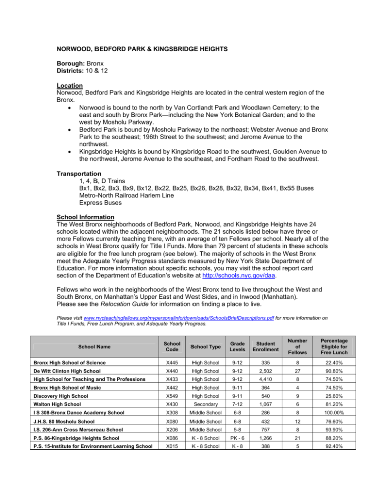
NORWOOD, BEDFORD PARK & KINGSBRIDGE HEIGHTS Borough: Bronx Districts: 10 & 12 Location Norwood, Bedford Park and Kingsbridge Heights are located in the central western region of the Bronx. • Norwood is bound to the north by Van Cortlandt Park and Woodlawn Cemetery; to the east and south by Bronx Park—including the New York Botanical Garden; and to the west by Mosholu Parkway. • Bedford Park is bound by Mosholu Parkway to the northeast; Webster Avenue and Bronx Park to the southeast; 196th Street to the southwest; and Jerome Avenue to the northwest. • Kingsbridge Heights is bound by Kingsbridge Road to the southwest, Goulden Avenue to the northwest, Jerome Avenue to the southeast, and Fordham Road to the southwest. Transportation 1, 4, B, D Trains Bx1, Bx2, Bx3, Bx9, Bx12, Bx22, Bx25, Bx26, Bx28, Bx32, Bx34, Bx41, Bx55 Buses Metro-North Railroad Harlem Line Express Buses School Information The West Bronx neighborhoods of Bedford Park, Norwood, and Kingsbridge Heights have 24 schools located within the adjacent neighborhoods. The 21 schools listed below have three or more Fellows currently teaching there, with an average of ten Fellows per school. Nearly all of the schools in West Bronx qualify for Title I Funds. More than 79 percent of students in these schools are eligible for the free lunch program (see below). The majority of schools in the West Bronx meet the Adequate Yearly Progress standards measured by New York State Department of Education. For more information about specific schools, you may visit the school report card section of the Department of Education’s website at http://schools.nyc.gov/daa. Fellows who work in the neighborhoods of the West Bronx tend to live throughout the West and South Bronx, on Manhattan’s Upper East and West Sides, and in Inwood (Manhattan). Please see the Relocation Guide for information on finding a place to live. Please visit www.nycteachingfellows.org/mypersonalinfo/downloads/SchoolsBriefDescriptions.pdf for more information on Title I Funds, Free Lunch Program, and Adequate Yearly Progress. Number of Fellows Percentage Eligible for Free Lunch 335 8 22.40% 2,502 27 90.80% School Code School Type Grade Levels Bronx High School of Science X445 High School 9-12 De Witt Clinton High School X440 High School 9-12 High School for Teaching and The Professions X433 High School 9-12 4,410 8 74.50% Bronx High School of Music X442 High School 9-11 364 4 74.50% Discovery High School X549 High School 9-11 540 9 25.60% Walton High School X430 Secondary 7-12 1,067 6 81.20% I S 308-Bronx Dance Academy School X308 Middle School 6-8 286 8 100.00% J.H.S. 80 Mosholu School X080 Middle School 6-8 432 12 76.60% I.S. 206-Ann Cross Mersereau School X206 Middle School 5-8 757 8 93.90% P.S. 86-Kingsbridge Heights School X086 K - 8 School PK - 6 1,266 21 88.20% P.S. 15-Institute for Environment Learning School X015 K - 8 School K-8 388 5 92.40% School Name Student Enrollment P.S. 20-George J. Werdan III School X020 Elementary K-8 1,676 24 82.70% P.S. 246-Poe Cottege School X246 Elementary K-6 1,225 8 91.40% P.S. 340 X340 Elementary K-6 1,046 3 88.70% P.S. 46 Edgar Allen Poe School X046 Elementary K-5 808 22 88.40% P.S. 94-Kings College School X094 574 22 77.00% X008 Elementary Elementary K-5 P.S. 8 - Briggs Avenue Academy K-5 725 5 69.50% P.S./I.S. 54 X054 Elementary K-5 540 7 92.50% P.S. 310-Marble Hill School X310 Elementary K-5 1,161 3 88.20% P.S. 291 X291 Elementary K-4 551 5 89.30% P.S. 168 X168 District 75 PK - 7 574 9 74.30% Neighborhood Demographic Data Demographic data from 2000 New York City Community District Census Data Median Household Income Total population under age 18 $27,577 Percent of Population 31.2% Ethnicity Hispanic Origin Black/African American White Asian or Pacific Islander Other American Indian and Alaskan Native 59.2% 20.0 10.7 6.4 3.4 0.3 Total foreign born population 36.7% Total population not proficient in English* 33.4% *Older than five years Brief History of the Norwood, Bedford Park & Kingsbridge Heights South of the modern-day New York City line, the Town of Kingsbridge and the entire western half of the Bronx were annexed by the City of New York in 1874 from the Town of Yonkers. The area now known as Bedford Park was mostly farmland and considered a suburb of New York City. The area began developing with the construction of the Jerome Park Racecourse--the first home of the famous Belmont Stakes horserace--until it was moved to Morris Park in 1890. To attract the wealthy to the Racecourse, Leonard Jerome, one of the original builders of the racecourse, built what is today Jerome Avenue. The neighborhood of Norwood (at times called Bainbridge because of its central street) was laid out in 1889 by Josiah Briggs between Mosholu Parkway and Woodlawn Cemetery. To store fresh water from the New Croton Aqueduct, construction began to convert Jerome Park into the Jerome Park Reservoir Manhattan in 1890. Bedford Park began to take shape, with forty "villas" built on a 23-acre stretch, in a planned community modeled on the London "garden" neighborhood named Bedford Park. The area became a part of the newly created Borough of the Bronx in 1898, and with the completion of Jerome Park Reservoir in 1906 became a valuable asset for the much-expanded New York City. The Italian and Irish immigrants who worked on the Jerome Park Reservoir project soon anchored the community there. With the completion of two major transportation projects, the Grand Concourse in 1916, a multilane thoroughfare, and the extension of the Inter-borough Rapid Transit (IRT) Jerome Avenue Line in 1917, development was in full swing. Along with the rest of the borough of the Bronx, these neighborhoods saw a boom in housing construction along the Grand Concourse in the post-World War I era. Much of this was from middle-class white ethnic (primarily Jews, Italians, and Irish) emigrants moving from crowded Manhattan to settle down in the area. From the 1970s through the 1990s the area was well known for its Irish population, having attracted a number of immigrants from Catholic areas of Northern Ireland who fled an Irish civil war known as the Troubles in the mid-twentieth century. The area contributed much in Irish and Irish-American culture and politics during this time. Since the mid- to late-‘90s, a number of factors, such as the American recession and an end to the Troubles, contributed to the emigration of the Irish population from this area, which by this time had come to be known as “Little Belfast.” Those who did not leave the country migrated to other Bronx neighborhoods and Westchester. As the Irish emigrated, the Latino community, consisting mostly of Puerto Rican and Dominican immigrants, pushed up from the South Bronx and Manhattan. At the time, Puerto Ricans were the city’s most sizeable Latino minority group, steadily arriving in New York City from the early 1900s for jobs and wartime demand for labor. The Dominican population, now the most sizeable minority group in New York, started arriving in noticeable numbers in the 1960s as economic disparity in the Dominican Republic increased. Caribbean and South American Latinos are now the majority in the area. Due to its unique location as a hub for close and easy public transportation, open space parks, excellent public schools, and nearby shopping venues, this cluster of West Bronx neighborhoods has recently seen a huge increase in population, building and commercial construction--including a new shopping complex opening this year. *Information in this section is from the following sources: http://www.forgotten-ny.com/NEIGHBORHOODS/norwood/norwood.html; http://en.wikipedia.org/wiki/Bedford_Park,_Bronx Gonzalez, Carolina & Kugel, Seth, Neuva York, St. Martin’s Griffin, New York, 2006, pgs.1-3 Cultural & Recreational Institutions • Williamsbridge Reservoir Oval, 3225 Reservoir Oval East • The Bronx County Historical Society, 3309 Bainbridge Avenue • The Jerome Park Reservoir, Sedgwick and Goulden Avenues • The Bronx Park, including The Bronx Botanical Gardens, between Southern Blvd, Webster Ave, Burke Ave, Bronx Park East and 180th St • Van Cortlandt Park, between Broadway, Jerome Ave, Van Cortlandt South and the city line bordering Yonkers • Kingsbridge Armory, Jerome Ave and West Kingsbridge Rd Further Research/Community Information http://www.lehman.edu/publicart/neighborhood.htm http://www.theamazingbronx.com
