BEAUTY IN THE ELEMENTS: A LOOK AT LANDFORMS
advertisement
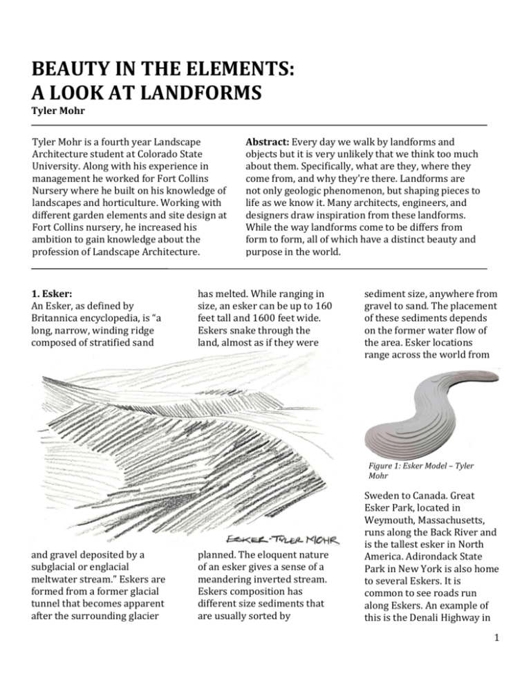
BEAUTY IN THE ELEMENTS: A LOOK AT LANDFORMS Tyler Mohr Tyler Mohr is a fourth year Landscape Architecture student at Colorado State University. Along with his experience in management he worked for Fort Collins Nursery where he built on his knowledge of landscapes and horticulture. Working with different garden elements and site design at Fort Collins nursery, he increased his ambition to gain knowledge about the profession of Landscape Architecture. 1. Esker: An Esker, as defined by Britannica encyclopedia, is “a long, narrow, winding ridge composed of stratified sand Abstract: Every day we walk by landforms and objects but it is very unlikely that we think too much about them. Specifically, what are they, where they come from, and why they’re there. Landforms are not only geologic phenomenon, but shaping pieces to life as we know it. Many architects, engineers, and designers draw inspiration from these landforms. While the way landforms come to be differs from form to form, all of which have a distinct beauty and purpose in the world. has melted. While ranging in size, an esker can be up to 160 feet tall and 1600 feet wide. Eskers snake through the land, almost as if they were sediment size, anywhere from gravel to sand. The placement of these sediments depends on the former water flow of the area. Esker locations range across the world from Figure 1: Esker Model – Tyler Mohr and gravel deposited by a subglacial or englacial meltwater stream.” Eskers are formed from a former glacial tunnel that becomes apparent after the surrounding glacier planned. The eloquent nature of an esker gives a sense of a meandering inverted stream. Eskers composition has different size sediments that are usually sorted by Sweden to Canada. Great Esker Park, located in Weymouth, Massachusetts, runs along the Back River and is the tallest esker in North America. Adirondack State Park in New York is also home to several Eskers. It is common to see roads run along Eskers. An example of this is the Denali Highway in 1 Alaska. Several designed landscapes and landscape elements resemble Eskers. A and 100 feet tall. Drumlins are known for their naturally occurring symmetry, resembling an upside-down spoon. Drumlins have a steep side ,the side that was the side located against the glacier, and a more gradual sloped side, which is the side opposite of the glacier. Figure 2: Esker Aerial – Location Unknown terrific example of a small, unnatural esker in a landscape is a berm or a mound. These can be used for drainage or just an aesthetically pleasing element. 2. Drumlin: Glaciers are associated and responsible for many naturally occurring landforms; One of which being a Drumlin. A drumlin is a naturally formed hill that can reach over a mile wide Figure 4: Drumlin Model – Tyler Mohr Drumlins are formed along the streamlined movement of a glacier using the sediments along the side, or till, to build up the drumlin. Though the size and composition of drumlins can vary, they usually have an approximate width to length ratio of 4:7. Though drumlins can be found alone in nature, it is common for drumlins to be found in sets of several or swarms, sometimes reaching up to over 1,000. Drumlins are found in many places around the world such as Europe, North America, South America, Asia, and Antarctica. Along with eskers, drumlins are commonly found in New York, Massachusetts, and other places in the New England area. Drumlins are also commonly found in Canada with every province or territory containing them. Many different designed landscapes contain features that resemble drumlins. Many berms are similar to drumlins, but a great example of a designed landscape containing drumlin-like elements is the U.S. Courthouse Plaza in Minneapolis. The plaza was designed by Martha Schwartz and is often times referred to as “Drumlin Park”. This plaza contains a set of grass berms that resemble swarms of Drumlins that naturally occur in nature. Figure 3: Wisconsin Drumlin 2 3. Moraine: A moraine is the material left behind by a moving glacier. Though this is a very broad definition, moraines can be classified into more specific categories such as Lateral are formed when two glaciers meet and the material between them is scraped and deposited. Superglacial Moraines are moraines made from the material found on top of a glacier when the glacier melts. Both Lateral and types of moraines, they can vary in size, shape, and composition. One aspect that stays constant throughout the different types of moraines is the fact that they are made of the material left behind after a glacier runs its course. Moraines have a build up of material and often times cause some of the most interesting and beautiful naturally occurring elements in nature. Moraines often times act as dams and can create ponds or lakes in some of the most unlikely of places, such as in mountainous valleys. Moraines are found in several different places, from Canada to Switzerland. 4. Jencks: Moraines, Medial Moraines, Superglacial Moraines, Ground Moraines, and Terminal Moraines. Lateral Moraines are formed when a glacier moves through a landscape and scrapes off material from both sides of the glacier. Medial Moraines Figure 5: Moraine in Canada Medial Moraines can be Superglacial. Ground Moraines are made from the compilation of the sediment found beneath a moving glacier. Unlike other moraines, ground moraines have an uneven shave and are irregularly distributed. Terminal Moraines, as the name indicates, are moraines found where a glacier ends. Similar to a bulldozer, terminal moraines are comprised of material that was picked up and pushed while the glacier was moving through a landscape. Because there are so many different Figure 6: Jencks/Oxbow Model – Tyler Mohr Charles Jencks is a landscape architect and theorist. He is responsible for several influential designs, but the Figure 7 – The Universe Cascade by Charles Jencks 3 landform that he is well known for is an elongated hill with almost terraced landings. The size and character of these hills varies from project Charles Jencks’ most beautiful projects and well-known landscapes is “Cells of Life” located in Eidenberg, Scotland. This landscape has to project but has a similar format regardless of the project. These rolling terraced hills are often times accompanied by a water feature. The hills also often time surrounding these water features giving them a backdrop that almost makes the water appear as if it isn’t completely flat. The contrasting ideas of a rolling hill mixed with a geometric terrace shape make these hills fascinating. Sometimes the terraced sections are parallel and organized, other times they are random and cross over one another. These landforms resemble smaller scale eskers and drumlins, but contain elements that make them more deliberate and planned than these naturally occurring features. One of these rolling terraced hills surrounding a pond with an island. This landscape is so striking that at first look, you may be fooled into thinking it is naturally occurring, but with further examination of the individual elements, you realize the eloquently designed nature of the site. 5. Pyramid: A pyramid is a threedimensional triangular structure that resembles the geometric shape of a pyramid. The amount of sides of a pyramid can vary, but usually has three or four. The most common and influential example of a pyramid is the Pyramids of Giza in Egypt. The pyramids of Giza have an estimated building date of around 2600 BCE. The most amazing part about these pyramids is their symmetry. When they were built there was no way of transporting the materials up and down the sides of the pyramid other than by manpower alone. The near perfect symmetry of these pyramids has baffled philosophers for hundreds of years and some people even Figure 8 – The Pyramids of Giza, Egypt 4 believe that the only way these pyramids could have been build so perfectly is by the help of some kind of nonhuman or extra-terrestrial life. The pyramid has a sleek shape that is very visually appealing. Some people Figure 9 – Pyramid Model – Tyler Mohr believe that the pyramid shape is meant to reflect the descending rays of the sun. While it is believed that most pyramids were build as burials and sanctuaries for important cultural leaders, some believe that pyramids were built to transport diseased inhabitants into the heavens for the afterlife. The pyramid of Khufu in Egypt is the only remaining site of The 7 Wonders of the World to still exist today. While pyramids are typically thought to have smooth sides, several pyramids are constructed in a “step” style. This means that the sides of the pyramids are steps that wrap around the structure and eventually lead to the top. The pyramids of Giza are step pyramids and this is thought to be how the workers that constructed the structure reached the top in the process of building. The chambers and tunnels within the pyramids was a system of random paths. There were many “false tunnels” that led to no where that were made to detour potential burglars from reaching the room that contained the diseased member and their belongings they were buried with. 6. Plinth: A plinth is traditionally thought of as a base to a column. Plinths, under a column, provide for stability as well as give a unique look to the column. A plinth is off. Plinths can be naturally occurring in rock formations. There are several examples of plinth rock formations in different parks. A specific example of this is “Balanced Rock” at the Garden Figure 11: Balanced Rock, Utah of the Gods in Colorado Springs. Here, a large rock balances on top of a plinth. The plinth acts as a stabilizer to the larger rock that sits on top of it. Though structures that resemble plinths are very Figure 10: Plinth Model – Tyler Mohr usually shaped as a trapezoidal box, meaning the base is slightly larger than the top. This shape resembles a pyramid with the top half cut prominent in different places throughout history, Mayans and Aztecs are very well known for using plinths in 5 landscapes. These formations are often times thought of as and pyramids have withstood the test of time and still exist pyramids, but they actually differ in a sense that they never come to a point at the top, but instead have a flat platform at their apex. These plinth formations were thought to be places for ancient rituals, sacrifices, and even burial mounds – similar to the pyramids in Egypt. Several Aztec and Mayan plinths still stand to this day. The largest and perhaps most astounding plinth formation in the world is The Great Pyramid of Cholula in the Mexican state Puebla. Depending on where you are viewing this Aztec structure from, The Great Pyramid of Cholula can appear as a grassy hillside or a constructed landscape element. It is thought that this great plinth was built nearly 2000 years ago. Because of their durability and environmentalfriendly shape, many plinths to this day in great condition. higher altitudes. Plains are different than plateaus in a sense that plateaus have a steep or several steep walls leading up to the flatland: Plains do not have this. The process of erosion forms plains. When all of the land topography changes erode away due to weather or other impacts, you are left with a plain. Plains are not typically thought to have a prominent role in landscapes, but many landscapes contain formations that almost mirror the characteristics of a Plain. Think of any grass field in 7. Plain: Plains are a section of land that has relatively low relief. Plains can be found in different types of environments such as near a Figure 12: Mammoth Cave Plain coast or farther inland. In most cases, plains are slightly lower in elevation than the land around them. Coastal plains usually continue up from the sea or ocean around them and continue on until they meet an area of land with higher relief such as a mountain. Inland plains can be found in a multitude of locations, but are common at parks, including soccer fields, football fields, and open grass areas. Though there aren’t too many defining characteristics or grade changes, all of these fields are taken from plains. Plains, while to the naked eye, may seem flat, but they aren’t. Their gradual grade change allows for rain to not accumulate and become a marshland. Grass playing fields are designed the same way: Whether the field is sloped from one end to the other, linearly from the center, or radial, all fields have a very subtle grade 6 change that helps them drain water. 8. Peak: Peaks are one of the most enormous and beautiful naturally occurring landforms in the world. Peaks are located all over the world. Tectonics. Plate Tectonics are responsible for several different landforms such as trenches and mid-ocean ridges, but none perhaps more beautiful than Peaks. Underneath the earth there is a set of “plates” that are ever changing. These plates fit Some of the most well known peaks are Mount Everest - the highest peak in the world, The Matterhorn - a spike shaped peak in the Swiss Alps, and Mount Olympus in Greece. Peaks can vary in size, shape, and other physical attributes. together similarly to a puzzle, and when these plates move they have a tendency to collide with one another. When this happens there are two options that result in the formation of mountain ranges: 1. The plates collide Figure 13: Peak Model by Tyler Mohr Peaks are found within mountain ranges and are usually substantially taller and larger than their surroundings. Mountain ranges and peaks are formed by a process called Plate plates collide and both of the plates are thrusted upward, thus also creating a mountain. The place where these plates collide is usually the place where the peak is located. This is because as the collision area begins to thrust upward, the surrounding areas also are, but the farther away from the collision spot, the longer it will take for the area to begin its upward thrust. Peaks play a crucial part in landscapes. One of the main reasons is attributed to their elevation. As elevation rises, the amount of vegetation decreases until an imaginary line called “tree line” is reached. Tree line is the point on a peak or a mountain range where you no longer see vegetation because it cannot survive at such a high elevation. Peaks viewed from a distance are usually very beautiful. Mt. Hood, in northern Oregon, is a prime example of a peak. Mt. Hood has a very circular shape that gives it a beautiful appearance. Mt. Hood reaches over 11,000ft in height and is usually covered in snow. Though Mt. Hood considered “dormant” meaning it has no volcanic activity at the time, it is considered the “most likely volcano to erupt” in Oregon. Figure 14: Mt. Hood, Oregon and one plate slides underneath the other, causing the upward plate to thrust up forming a mountain. 2. The 7 9. Saddle: A saddle is the area between two mountains and is also referred to as a “Mountain Pass”. Saddles are characterized by being the roads run through. When making a path or road through the mountains, it is ideal to weave through the mountains while staying at the lowest elevation possible in attempt to limit distance Peak and Mount Meeker. Longs Peak reaches over 14,000ft and Mount Meeker is close behind, just under 14,000 feet. These magnificent peaks and their saddle can be seen from Longmont, Colorado. 10. Mound: Mounds, though visually simple, are complex by nature. Mounds are nearly symmetrical spherical convex protrusions coming from the land. Mounds can range vastly Figure 15: Mt. Meeker Saddle lowest point between two mountaintops, but the highest point between the to perpendicular valleys. In a sense, a saddle is a perpendicular mountain in between two other mountains. This definition stays true with an actual saddle, such as one you would use on a horse. Saddles are usually places where paths or traveled. In the case of a road, staying at the lowest elevation possible throughout the mountains is to minimize the amount of paving and money spent as possible. Saddles between mountains mark the highest point that these paths or roads will travel over to get to the destination. Saddles occur in virtually every mountain range that exists and the size or length of these saddles can vary greatly depending on mountain size, distance between mountains, and mountain width. An excellent example of a saddle is the area between Longs Figure 16: Burial Mound, Hungary in size from small, unintentional bumps on the ground to enormous landforms. Mounds are constructed by deliberately piling heaps of soil, rock, or other land types into a given area in a symmetrical shape. The most popular form of mounds used in history are by Native Americans. Native Americans used mounds as 8 burial areas for their diseased and gathering places. Native American burial mounds are found in different places across the United States, each characterize this open space. After 4 years of construction, this open space was opened in 2008. The largest of the mounds is 22 acres and Figure 17: Mound/Kettle Model by Tyler Mohr having different characteristics. It is believed that mounds have been a part of landscapes since the B.C. era, and a mound that is though to be 3500 years old was recently discovered in Arkansas. Mounds were also used as one of the first forms of small-scale horticulture. Plantings would take place on these mounds due to their soil vastness and. After burying a body in the mound, they would plant different food providing plants over it to help supplement their hunting. Many of these mounds from thousands of years ago still exist today. A more recent example of mounds in a landscape is the Northala Fields in London. Several large-scale mounds that are covered in grass A kettle is a depression in the land that is formed with a partially buried portion of ice melts and leaves an imprint. When glaciers start to recede, pieces of them often time break off and are wedged into the ground. These wedged ice pieces are responsible for the kettle depression in the land after the ice bit melts. Kettles are often times filled with Figure 18: Kettle Lakes, Canada provides for a view of the surrounding areas, including Central London and Canary Wharf. These mounds were build with different soils, all of which can facilitate different vegetation growth and sustainability. 11. Kettle: water, vegetation, and other sediments. When a kettle is filled with water it is referred to a kettle lake. Kettle lakes can be shallow and wide, deep and small, or any combination of sizes. When vegetation and moisture accumulate in these kettles a bog is formed. Many lakes in the Michigan area are 9 defined as kettle lakes. A very well known, if not the most well known kettle lake is Walden Pond in Concord, Massachusetts. Though the name pond usually indicates a smaller body of water, Walden Pond is anything but that; spanning over 60 acres and reaching to depths of over 100ft. As with most kettle lakes, Walden Pond was created by retreating glaciers an estimated 10-12 thousand years ago. Kettle lakes immense beauty comes from the fact that they are naturally Figure 19: Mound/Kettle Model by Tyler Mohr occurring. Glaciers are responsible for several different landforms, but perhaps none as vast and breathtaking as kettle lakes. 12. Oxbow: An oxbow is an atypical type of lake. When people think of lakes, they think of a circular or ovular shape filled with water. Oxbows are different in a way that they aren’t shaped like a usual lake, but instead are crescent shaped. Oxbows are found along the side of rivers and this is due to the way that they are formed. Oxbows were initially a part of a meandering river system. Over time as the meandering river starts to erode and decompose, the edges of different bends in the river will meet, eventually voiding the original u shaped edge of the river no longer relevant. As this former path of the river ages, the edges of the riverbank build up and leave the crescent shape former path of the river filled with water, thus forming the oxbow. The Nowitna river in Alaska has a perfect example of an oxbow in the making. Though the river has not fully eliminated the bank separating the two edges of the river, it is only a matter of time and meters until the river will eventually form an oxbow. The crescent shape of an oxbow as well as the elegant shape of meandering rivers is very influential in not only landscapes but also Figure 21: Near Oxbow Formation, Location Unknown paintings. The natural flowing shape and natural repetition of a meandering river is a common pattern used in different instances throughout landscape history. Figure 20: Jencks/Oxbow Model – Tyler Mohr 13. Escarpment: An escarpment is defined as a long cliff that can occur due to a couple of natural processes. The first being erosion. When one area of ground differs from another, the softer soil will tend to erode at a more 10 rapid rate. When this occurs to a great extent in a linear formation a cliff is often times formed. The second way an escarpment can form is on a one area of land from another. An example of an escarpment occurring in nature is the Niagara escarpment that runs all the way from New York to fault line. A fault line is an imaginary line that divides two separate moving pieces of land. When these pieces of land converge or diverge, the land level changes. When they converge, one piece of land is Ontario Canada. This escarpment, as with most, is characterized by two different types of sedimentary rock that erode at a different rate. This difference in erosion rate causes many variations in cliff size and area. A picturesque example of an escarpment is Niagara Falls. Niagara Falls defines the southern end of the Niagara Gorge. Niagara Falls is a waterfall area where the Niagara River crosses over the great Niagara Fault line forming some of the most massive and popular waterfalls in the United States. Niagara Falls is a popular tourist spot for people in the United States as well as people from other counties due to its vast size and the ability to get up close Figure 22: Niagara Falls, New York usually forced below the other, leaving the upper land hanging over and thus forming a cliff or escarpment. Escarpments are often times describes as a sudden change in land elevation that divides and personal with the cliff and waterfalls. 14. Anticline: An anticline is an area where layers of rock are stacked and then bent, forming a convex land formation. Similar to a hill, an anticline has two sloped sides and an apex. A similar landform to an anticline is a syncline. The Figure 23: Zagros Mountain Anticline difference between the two is that an anticline forms a hill and protrudes from the earth’s surface where as a syncline forms a gap in the earth and has a concave shape. Both of which still have layered sheet rock composing them. Anticlines can be one singular fold of rock or a set of rolling hills composed of these layers of rock. The layers of rock are organized by age, the layer at the top being the newest and the layer on the bottom of the fold being the 11 oldest. If an anticline has existed for a long time, the top apex or top point to the anticline. Anticlines are found Figure 24: Anticline Model by Tyler Mohr layer will often times be eroded and from a section view, it will look as though there is not actually a true all over the world and are formed from various types of rock. The reason that anticlines are so common is because they can occur anywhere there is a fault line or fault movement. When driving through a mountainous area where roads have been carved, it is easy to see these anticlines and layers of rock that compose them. Anticlines range in size, from small rock formations that are no taller than the size of a human to anticlines that form a whole hillside or mountain, such as can be found Ehdan, Lebanon. The scale of the anticline can be determined by age and strength of fault. 12 Resources: http://www.landforms .eu/cairngorms/esker. htm http://www.aztechistory.com/cholulapyramid.html http://www.encyclope diaofarkansas.net/enc yclopedia/entrydetail.aspx?entryID=57 3 http://www.mass.gov/ dcr/parks/walden/ http://www.britannica .com/EBchecked/topic /192505/esker http://www.britannica .com/EBchecked/topic /172086/drumlin http://www.collaborat ivelandscape.org/wiki /US_Courthouse_Plaza, _Minneapolis,_MN http://www.mbgnet.n et/fresh/lakes/oxbow. htm http://education.natio nalgeographic.com/ed ucation/encyclopedia/ moraine/?ar_a=1 http://education.natio nalgeographic.com/ed ucation/encyclopedia/ escarpment/?ar_a=1 http://science.yourdict ionary.com/anticline http://www.charlesjen cks.com/#!projectsjupiter-artland http://www.discoveri ngegypt.com/pyramid 3.htm http://www.edu.pe.ca /southernkings/plain mr.htm http://www.pbs.org/w gbh/nova/everest/ear th/birth.html http://www.springsgo v.com/Page.aspx?NavI D=86 13
