MMFs/CRMs/SuperParam
advertisement
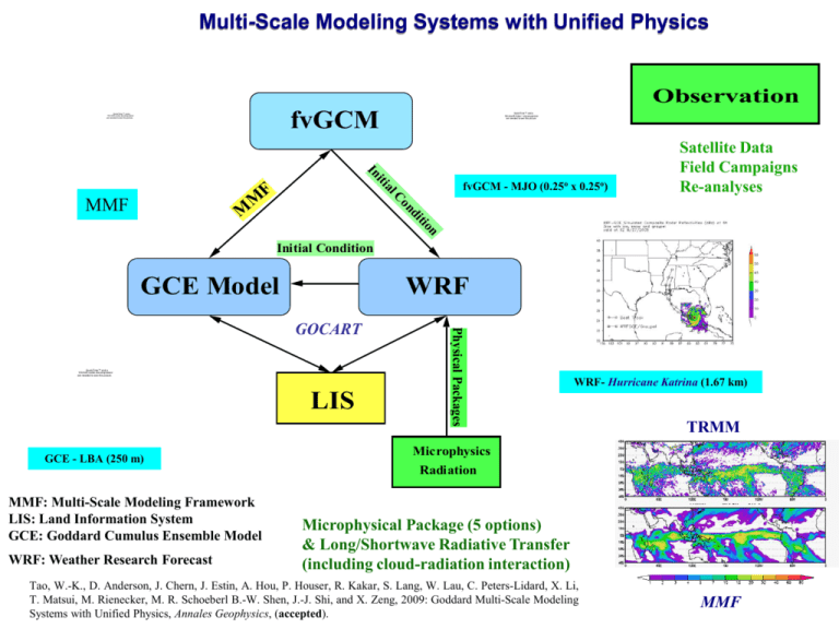
Multi-Scale Modeling Systems with Unified Physics Observation fvGCM QuickTime™ and a YUV420 codec decompressor are needed to see this picture. QuickTime™ and a Microsoft Video 1 decompressor are needed to see this picture. i In di on lC n tio M fvGCM - MJO (0.25o x 0.25o) tia MMF F M Satellite Data Field Campaigns Re-analyses Initial Condition GCE Model WRF QuickTime™ and a YUV420 codec decompressor are needed to see this picture. LIS GCE - LBA (250 m) Physical Packages GOCART WRF- Hurricane Katrina (1.67 km) TRMM Microphysics Radiation MMF: Multi-Scale Modeling Framework LIS: Land Information System GCE: Goddard Cumulus Ensemble Model WRF: Weather Research Forecast Microphysical Package (5 options) & Long/Shortwave Radiative Transfer (including cloud-radiation interaction) Tao, W.-K., D. Anderson, J. Chern, J. Estin, A. Hou, P. Houser, R. Kakar, S. Lang, W. Lau, C. Peters-Lidard, X. Li, T. Matsui, M. Rienecker, M. R. Schoeberl B.-W. Shen, J.-J. Shi, and X. Zeng, 2009: Goddard Multi-Scale Modeling Systems with Unified Physics, Annales Geophysics, (accepted). MMF Improving the Simulation of Convective Cloud Systems: higher resolution and improved ice physics The Goddard Cumulus Ensemble (GCE) model is a cloud-resolving model developed at NASA Goddard by the Mesoscale and Dynamics Group to simulate convective cloud systems. QuickTime™ and a YUV420 codec decompressor are needed to see this picture. High resolution simulation of 23 Feb 1999 TRMM LBA case qs qg Improvements to the cloud microphysics results in less high-density ice and more realistic hydrometeor profiles for use in satellite retrievals Image by J. Williams (Scientific Visualization Studio) qs Higher horizontal model resolution leads to a more realistic, gradual transition from shallow to deep convection qg Need to continue improve the microphysics Lang, S., W.-K. Tao, R. Cifelli , W. Olson, J. Halverson, S. Rutledge, and J. Simpson, 2007: Improving simulations of convective systems from TRMM LBA: Easterly and westerly regimes. J. Atmos. Sci., 64, 1141-1164. TOGA COARE MJO Like GATE Tao (2003) Multiscale convective organization in a two-dimensio nal CRM with a 20,000 k m domain: westwardpropagating precipitating systems embedded in a eastward-propagating cloud-cluster envelopes. The vertical section shows the three -branch MCS-type airflow organization of the westward-movin g systems. The multiscal e organization de veloped from a randomly perturbed horizontally homogenou s motionless state. Adapted from Grabowsk i andMoncrieff [2001]. NASA Unified WRF WRF-Chem GOCART Cloud/Aerosol Direct Effect Goddard Radiative Transfer Packages Initial Condiiton from GEOS5 for NASA Field Campaigns Cloud Optical Properties Aerosol Indirect Effect Goddard Microphysical Packages Cloud-Mesoscale Dyanmics (Circulation) Thermodynamic (Stability Precipitation Radiation ) Rain Fall Asimilation Sfc Fluxes Land Information System (LIS) Land Surface Model Urban Heat Island Effect Blue Boxes: NASA Physical Packages Integrated Modeling of Aerosol, Cloud, Precipitation and Land Processes at Satellite-Resolved Scales Co-PIs: Christa Peters-Lidard, Wei-Kuo Tao, and Mian Chin Co-Is: Scott Braun, Jonathan Case, Arthur Hou, Sujay Kumar, William Lau, Toshihisa Matsui, Tim Miller, Joseph Santanello, Jr., Jainn Shi, David Starr, Qian Tan, Benjamin Zaitchik, Jing Zeng, Sara Zhang High-resolution GEOS5 forcing Land-surface initialization & spin up with NLDAS Ensemble Rainfall Assimilation Satellite & analysis Short-term integration US weather prediction Continental MCSs Hurricanes Air Pollution NASA Unified WRF Physics GOCART aerosol transport model Goddard Microphysics Goddard Radiation Land Surface Models within LIS Land-atmosphere interaction Aerosol Direct & Indirect Effect Long-term integration US summer climatology (North American Monsoon, drought, diurnal cycle, Aerosol Impact) Shape/size of the eye WRF simulated snow 1 min NASA Ames Visualization Group QuickTime™ and a YUV420 codec decompressor are needed to see this picture. Katrina 2005 Resolutions: 15, 5 and 1.667 km Grid size: 300x200, , 418x427, 373x382 Dt = 60, 20, 6.67 seconds Starting time: 00Z 8/27/2005 Initial and Boundary Conditions: NCEP/GFS, with bogus but no data assimilation NASA Goddard MMF Moist physics tendencies (T and q) Cloud and precipitation Z => P GCE fvGCM Z <= P Large-scale forcing, Background profiles (T, q, u, v, w) NASA MMF Goddard fvGC M – GC E Mo del 2 x 2.5 degree (13,104 CRM s) Microph ysics (>40 processes) Positive definite advec tion scheme 1.5 order TKE Radiation (every 3 min) Time step (10 s) 28 vertical layers (32 in fvGC M) V Š Component (no PGF) Online cloud statistics (every 2 min) 278 hours/per simulated year o n a 512 CPU computer 2D GCE has 64 x 28 (x-z) grid points with 4 km horizontal resolution fvGCM and GCE coupling time is one hour Interpolation between hybrid P (fvGCM) and Z (GCE) coordinate: using finitevolume Piecewise Parabolic Mapping (PPM) to conserve mass, momentum and moist static energy Tao, W.-K., J. Chern, R. Atlas, D. Randall, X. Lin, M. Khairoutdinov, J._L. Li, D. E. Waliser, A. Hou, C. Peters-Lidard, W. Lau,J. Jiang and J. Simpson, 2009: Multiscale modeling system: Development, applications and critical issues, Bull. Amer. Meteor. Soc. 90, 515-534. Goddard Multiscale Modeling Framework (MMF) QuickTime™ and a YUV420 codec decompressor are needed to see this picture. 1) Tropical waves move off the coast of Africa and propagate westward. [ It is known that tropical cyclogenesis can be initialized (or triggered) by these tropical waves. Therefore, accurate simulations of their interactions with small-scale convection are important for improving the simulations of TC genesis. ] 2) The eastward-traveling system in the southern hemisphere (SH) are the so-called the polar vortex, which is most powerful in the hemisphere's winter (JJAS, in the SH). 3) The equatorial Amazon has abundant rain between November and May. During the Brazilian spring season (October/November/December), most of the countries get wetter, except for the Brazilian northeast. 4) In comparison, during this period (winter in the northern hemisphere), mid-latitude periodic frontal systems move eastward across the USA. 5) Near the end of simulations, heavy precipitations appear near the ITCZ NASA Goddard Multiscale Modeling System simulated MJO QuickTime™ and a YUV420 codec decompressor are needed to see this picture. In a 30-day simulation of the MJO in late 2006 and early 2007, it is found that the location and propagation speed of the MJO are simulated reasonably well, including the formation of large-scale convective system in the Indian Ocean and its eastward propagation. Monthly precipitation and local time of precipitation frequency maximum over West Africa MMF captured satellite observed surface precipitation and its diurnal variation. The results imply that the MMF could be used to study local and regional surface water/energy cycle MMF TRMM TMI TRMM Combined MMF GCM GCM TRMM Geographical distribution of the local solar time (LST) of non-drizzle precipitation frequency maximum over West Africa in summer 1999 as simulated with the Goddard MMF (upper panel) and the GCM (middle panel) and as observed by the TRMM TMI (bottom panel). Blank regions indicate no precipitation. Monthly precipitation rates (mm/day) over West Africa for September 1999 from TRMM observations (TMI, top-left, and Combined, top-right) and simulations from the Goddard MMF (lower-left panel) and the GCM (lower-right panel). Diurnal Cycle of Summer Precipitation over USA along 35N Merge MV (1998-2005) 12 LST 00 LST 12 LST 00 LST 12 LST GCM (1998-1999) MMF (1998-1999) YOTC • MMF: 1997 - present / MJO simulation (Oct 08 - June 09) • WRF: Target Integration • CRM: Driven by MERRA (Forcing/Tendency) WRF Simulated Snow 6.67 s, 1.67 km resolution QuickTime™ and a YUV420 codec decompressor are needed to see this picture. CloudSat-observed and WRF-simulated Ze Low Cloud Trajectory/Inert tracer Website for mesoscale modeling group and cloud library http://portal.nccs.nasa.gov/cloudlibrary/index2.html Middle-high cloud Multi-layer cloud QuickTime™ and a YUV420 codec decompressor are needed to see this picture.
