FINAL TAKEHOME EXAM - LSU Geology & Geophysics
advertisement
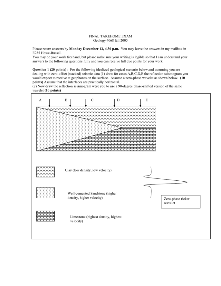
FINAL TAKEHOME EXAM Geology 4068 fall 2005 Please return answers by Monday December 12, 4.30 p.m. You may leave the answers in my mailbox in E235 Howe-Russell. You may do your work freehand, but please make sure your writing is legible so that I can understand your answers to the following questions fully and you can receive full due points for your work. Question 1 (20 points) : For the following idealized geological scenario below,and assuming you are dealing with zero-offset (stacked) seismic data (1) draw for cases A,B,C,D,E the reflection seismogram you would expect to receive at geophones on the surface. Assume a zero-phase wavelet as shown below. (10 points) Assume that the interfaces are practically horizontal. (2) Now draw the reflection seismogram were you to use a 90-degree phase-shifted version of the same wavelet (10 points) A B C D E Clay (low density, low velocity) Well-cemented Sandstone (higher density, higher velocity) Limestone (highest density, highest velocity) Zero-phase ricker wavelet Question 2 (10 Points) Calculate the maximum fold for the following cases: Geophone spacing (m) Number of geophones 3 6 6 6 3 6 3 6 Shot spacing (m) 3 3 6 9 Number of shots 12 12 12 12 Question 3 (20 points) We have as an objective to image using reflection seismology, a lens-shaped, sandy aquifer embedded in shale, at a shallowest depth of 200 m The setting has steep faults that cut the lens in two and displace its segments vertically with respect to each other. The lens of sand is about 20 m thick at its thickest point and about 1000 m long. Your vertical resolution must be 10 m or better. Design the experiment. Be sure to include the following (1 point each for the following) (1) geophone number and spacing, (2) shot number and spacing. (3) Explain what characteristics of the source signal must be in order to achieve good a vertical resolution of 10 m. (4) What will the horizontal resolution be? (5) How can you improve the horizontal resolution? (6) What is the dominant frequency? (7) What will your Nyquist frequency be? (8) What should you make your sampling rate? (9) What will your spatial aliasing be? (11 points for the following) In a quantitative fashion explain your error in the estimation of the size of the aquifer. Question 4 (50 points) If you had a fairly thick horizontal layer of basalt (approximately 200 m thick) whose top lies at 100 m depth embedded in sandstone (above and below) (1) calculate the VRMS to the top and to the bottom of the layer. (5 points) (2) Draw all the seismic events you would expect to see. (5 points) (3) Draw the expected change in amplitude with offset you expect to see in a very long shotpoint gather ( say, maximum offset is 10 km, and geophone spacing is 25 m) (5 points) (4) Calculate critical distance for the top interface. (5 points) (5) Calculate the shape of each of your seismic events at no more than 3 points and enough to show the general shape of your events. (10 points) (6) Calculate and draw how your seismic events would appear if you moved out your CMP data about 80% of total NMO velocity. (10 points) (7) Calculate at no more than 3 points and enough to show the general shape of your shallowest seismic reflection event in a SP gather if the layer were dipping 20 degrees to the right on the page. (10 points)


![Frequency [Hz]](http://s2.studylib.net/store/data/018531312_1-8319e88ced14e500b57144b076580c19-300x300.png)
