Prince William County Field Trip
advertisement
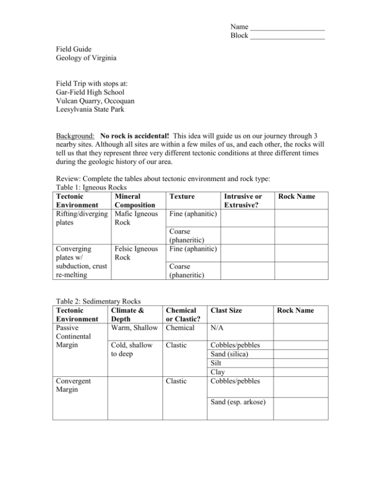
Name ____________________ Block ____________________ Field Guide Geology of Virginia Field Trip with stops at: Gar-Field High School Vulcan Quarry, Occoquan Leesylvania State Park Background No rock is accidental! This idea will guide us on our journey through 3 nearby sites. Although all sites are within a few miles of us, and each other, the rocks will tell us that they represent three very different tectonic conditions at three different times during the geologic history of our area. Review: Complete the tables about tectonic environment and rock type: Table 1: Igneous Rocks Tectonic Mineral Texture Intrusive or Environment Composition Extrusive? Rifting/diverging Mafic Igneous Fine (aphanitic) plates Rock Coarse (phaneritic) Converging Felsic Igneous Fine (aphanitic) plates w/ Rock subduction, crust Coarse re-melting (phaneritic) Table 2: Sedimentary Rocks Tectonic Climate & Environment Depth Passive Warm, Shallow Continental Margin Cold, shallow to deep Convergent Margin Chemical or Clastic? Chemical Clast Size Clastic Cobbles/pebbles Sand (silica) Silt Clay Cobbles/pebbles Clastic N/A Sand (esp. arkose) Rock Name Rock Name Name ____________________ Block ____________________ Table 3: Metamorphic Rocks Tectonic Local or Regional Event? Environment Convergent Plates Regional – compression, folding Metamorphic Grade High Rock Name Low Convergent or Divergent Local - Volcanism/Contact Metamorphosis Field Trip Data: Stop 1: Gar-Field High School Type of Rock (if igneous) Ign, Sed, Meta Intrusive or Extrusive? (overlying) (basement) Additional Notes Rock Name(s) Mineral Composition Tectonic Conditions at Time of Formation Name ____________________ Block ____________________ Stop 2: Vulcan Quarry, Occoquan Type of Rock Intrusive or Mafic or Felsic Extrusive? Igneous? Mineral Composition Rock Name(s) Tectonic Conditions at Time of Formation Mineral Composition Rock Name(s) Tectonic Conditions at Time of Formation (main rock) (dikes) Additional Notes Stop 3: Leesylvania State Park Chemical or Clast Size Clastic? Additional Notes: Bedding planes are present. Do they all run the same way, or do layers alternate? Name ____________________ Block ____________________ Relevant other data: Refer to the tectonic history on the next two pages to help answer these questions. Use a separate sheet if necessary. 1. The basement rocks at Gar-Field High School were part of the Chopowamsic Formation, originally formed about 500 mya as a volcanic arc of islands off the coast of what is now North America. What tectonic environment would have created a volcanic island arc? 2. The Chopowamsic rock was originally granite. What tectonic event(s) likely caused it to become metamorphic? 3. The granite at Occoquan is only slightly metamorphosed. It is intruded into the Chopowansic Formation. Is the Occoquan Granite younger than, or older than, the Chopowamsic formation? Why do you think so? 4. What tectonic environment would favor the felsic vulcanism that created the Occoquan? 5. Are the basaltic dikes in the granite older than, or younger than, the Occoquan Granite? Why do you think so? 6. What tectonic environment would have produced the basaltic dikes in the Occoquan? 7. The overlying sediment at Gar-Field High School, and the Potomac Formation at Leesylvania State Park were deposited during the Cretaceous Period. What was the tectonic environment when those sediments were deposited? 8. Was this depositional environment at Leesylvania deep water, or shallow tidal water? Why do you think so? Name ____________________ Block ____________________ Name ____________________ Block ____________________ Name ____________________ Block ____________________ Fred Kourmadas Geology of Virginia 11/2/2006 Local Field Trip Lesson Plan ES.1e The student will plan and conduct investigations in which a scientific viewpoint is constructed and defended (the nature of science). ES.2 The student will demonstrate scientific reasoning and logic by a) analyzing how science explains and predicts the interactions and dynamics of complex Earth systems; b) recognizing that evidence is required to evaluate hypotheses and explanations; c) comparing different scientific explanations for a set of observations about the Earth; d) explaining that observation and logic are essential for reaching a conclusion; and e) evaluating evidence for scientific theories. ES.5 The student will investigate and understand how to identify major rock-forming and ore minerals based on physical and chemical properties. Key concepts include a) hardness, color and streak, luster, cleavage, fracture, and unique properties; and uses of minerals. ES.6 The student will investigate and understand the rock cycle as it relates to the origin and transformation of rock types and how to identify common rock types based on mineral composition and textures. Key concepts include a) igneous (intrusive and extrusive) rocks; b) sedimentary (clastic and chemical) rocks; and c) metamorphic (foliated and unfoliated) rocks. ES.7 The student will investigate and understand the differences between renewable and nonrenewable resources. Key concepts include a) fossil fuels, minerals, rocks, water, and vegetation; c) resources found in Virginia; d) making informed judgments related to resource use and its effects on Earth systems; and environmental costs and benefits. ES.8 The student will investigate and understand geologic processes including plate tectonics. Key concepts include a) how geologic processes are evidenced in the physiographic provinces of Virginia including the Coastal Plain, Piedmont, Blue Ridge, Valley and Ridge, and Appalachian Plateau; b) processes (faulting, folding, volcanism, metamorphism, weathering, erosion, deposition, and sedimentation) and their resulting features; and c) tectonic processes (subduction, rifting and sea floor spreading, and continental collision). Name ____________________ Block ____________________ Note: The field trip ideally would be planned for a time after the students have learned rocks, the rock cycle, and have been at least introduced to the Wilson Cycle. Engage - Students will be issued their field guides, and as a warm up, perhaps even on the bus, they are to complete the tables about rock types, as related to tectonic environment. Explore/Explain - Data tables for each site focus students on data that will be relevant later in reconstructing the tectonic history of the area. Teacher will circulate and check for understanding, drawing attention to relevant details (folding of rock layer and unconformity at Gar-Field, mafic dikes and slight gnessic banding to the Occoquan Granite, bedding planes at Leesylvania, etc.) Evaluate – Students will complete the short-answer questions at the end of their field guide for homework, due the next class. Packets will be collected, then the teacher will review the answers. Grading Rubric 90 Possible Points, as follows: Tables 1 through 3 20 points total Site Data, sites 1 through 3 Reflection Questions 30 total points (10 points each table. Table 3, additional notes MUST mention cross-bedding (5 points) 5 points each, 40 points total Minus 1 for each box left bland or having the wrong answer Minus 1 for each box left bland or having the wrong answer Each question will be awarded: 0-2 points for conceptual understanding 0-2 points for content knowledge 0 to 1 point for clarity
