Interpretation "Cheat Sheet"
advertisement

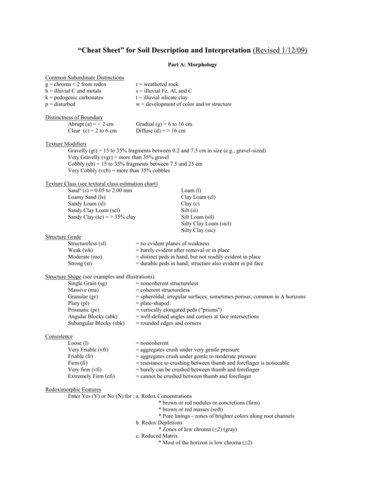
“Cheat Sheet” for Soil Description and Interpretation (Revised 1/12/09) Part A: Morphology Common Subordinate Distinctions g = chroma < 2 from redox h = illuvial C and metals k = pedogenic carbonates p = disturbed r = weathered rock s = illuvial Fe, Al, and C t = illuvial silicate clay w = development of color and/or structure Distinctness of Boundary Abrupt (a) = < 2 cm Clear (c) = 2 to 6 cm Gradual (g) = 6 to 16 cm Diffuse (d) = > 16 cm Texture Modifiers Gravelly (gr) = 15 to 35% fragments between 0.2 and 7.5 cm in size (e.g., gravel-sized) Very Gravelly (vgr) = more than 35% gravel Cobbly (cb) = 15 to 35% fragments between 7.5 and 25 cm Very Cobbly (vcb) = more than 35% cobbles Texture Class (see textural class estimation chart) Sand1 (s) = 0.05 to 2.00 mm Loamy Sand (ls) Sandy Loam (sl) Sandy Clay Loam (scl) Sandy Clay (sc) = > 35% clay Structure Grade Structureless (sl) Weak (wk) Moderate (mo) Strong (st) Loam (l) Clay Loam (cl) Clay (c) Silt (si) Silt Loam (sil) Silty Clay Loam (sicl) Silty Clay (sic) = no evident planes of weakness = barely evident after removal or in place = distinct peds in hand, but not readily evident in place = durable peds in hand; structure also evident in pit face Structure Shape (see examples and illustrations) Single Grain (sg) = noncoherent structureless Massive (ma) = coherent structureless Granular (gr) = spheroidal; irregular surfaces; sometimes porous; common in A horizons Platy (pl) = plate-shaped Prismatic (pr) = vertically elongated peds ("prisms") Angular Blocky (abk) = well-defined angles and corners at face intersections Subangular Blocky (sbk) = rounded edges and corners Consistence Loose (l) Very Friable (vfr) Friable (fr) Firm (fi) Very firm (vfi) Extremely Firm (efi) = noncoherent = aggregates crush under very gentle pressure = aggregates crush under gentle to moderate pressure = resistance to crushing between thumb and forefinger is noticeable = barely can be crushed between thumb and forefinger = cannot be crushed between thumb and forefinger Redoximorphic Features Enter Yes (Y) or No (N) for : a. Redox Concentrations * brown or red nodules or concretions (firm) * brown or red masses (soft) * Pore linings - zones of brighter colors along root channels b. Redox Depletions * Zones of low chroma (≤2) (gray) c. Reduced Matrix * Most of the horizon is low chroma (≤2) Part B: Soil Profile Properties and Interpretations Infiltration Rate (Maximum rate water enters soil through the uppermost horizon, in cm/hour) High: Moderate: Low: >7.5 cm/hour = s and ls; sl with > 2% organic matter 0.5 to 7.5 cm/hour = sl with < 2% organic matter; sil, sicl, scl, l, cl with mo or strong structure; sc and c with strong structure <0.5 cm/hour = sicl, sic, scl, sc, l, and cl with wk structure; c with wk to mo structure ___________________________________________________________________________________________________ Available Water (Water held between field capacity and permanent wilting point; estimated for top 150 cm) Available water capacity (AWC), expressed as cm of water per 150 cm of soil, can be estimated from textural class and coarse fragment content. A weighted average is determined using horizon thicknesses to 150 cm depth; however, if there is a root-restricting layer use the depth to the top of that layer. Start with the assumed values in the following table: -------------------------------------------------------------------------------------------cm of water/cm of soil texture 0.05 s, ls 0.15 sl, scl, cl, l, sic, sc, c 0.20 sil, si, sicl --------------------------------------------------------------------------------------------Available water capacity classes: Very low ≤7.5 cm Low > 7.5 to 15 cm Moderate > 15 to 22.5 cm High > 22.5 to 30 cm Very high > 30 cm Example of available water capacity (AWC) calculation for a soil. ------------------------------------------------------------------------------------------------------------------------------Bottom ThickCoarse Hor- Depth ness Textural Fragments AWC "formula" by horizon izon (cm) (T in cm) Class cm/cm (F in %) (cm) ------------------------------------------------------------------------------------------------------------------------------T*(cm/cm)*(1-F*0.01) A E B C 20 50 120 150 20 30 70 30 s s scl sl 0.05 0.05 0.15 0.15 2 5 5 7 20*(0.05)*(1-0.02) = 0.98 30*(0.05)*(1-0.05) = 1.43 70*(0.15)*(1-0.05) = 9.98 30*(0.15)*(1-0.07) = 4.19 --------Total 16.58 cm Thus AWC for this soil would be Moderate. Remember: You only go to 150 cm. If the bottom horizon goes deeper, stop at that depth. Also stop at the top of any compact layer that prevents root growth below that depth. ____________________________________________________________________________________________________ Hydraulic Conductivity (Rate water flows through soils under saturated conditions; ordinarily expressed in distance/time units, but for soil judging we only rate as "high, moderate, or slow" based mainly on texture and consistence) High = sand or loamy sand Moderate = Neither high nor low Low = Clayey with wk structure; cemented horizons. ____________________________________________________________________________________________________ Seasonal High Water Table Depth (based on presence of contemporary redoximorphic features) >150 cm 100 to 150 cm 50 to <100 cm 25 to < 50 cm <25 cm Soil Interpretations Dwellings with Basement: Adapted from NSSH Table 620-3 but modified to fit guidelines in the Southeast Region Handbook for Collegiate Soils Contest. Degree of Limitations Factors Affecting Use 1. Flooding or Ponding Frequency 2. Slope, % 3. Depth to Seasonally High Water Table, cm Slight (1) Moderate (2) None Not a choice Severe (3) Rare to Frequent <6 6 - 20 >20 >100 50 - 100 <50 4. Depth to Soft Rock (Cr), cm >100 50 - 100 <50 5. Depth to Hard Rock (R), cm >150 100 - 150 <100 Septic Tank Absorption Fields: Adapted from NSSH Table 620-17 but modified to fit guidelines in the Southeast Region Handbook for Collegiate Soils Contest. Degree of Limitations Factors Affecting Use 1. Flooding or Ponding Frequency 2. Slope, % Slight (1) None <6 Moderate (2) Not a choice Rare to Frequent 6 - 20 >20 <100 3. Depth to Seasonally High Water Table, cm >150 100 - 150 4. Limiting Hydraulic Conductivity Moderate Not a choice >150 100 - 150 5. Depth to Rock (R or Cr), cm Severe (3) Low (percs slowly) High (poor filter) <100 Local Roads and Streets: Adapted from NSSH Table 620-5 but modified to fit guidelines in the Southeast Region Handbook for Collegiate Soils Contest. Degree of Limitations Factors Affecting Use Slight (1) Moderate (2) 1. Flooding or Ponding Frequency None Not a choice 2. Slope, % <6 3. Depth to Seasonally High Water Table, cm >50 50 - 25 <25 4. Depth to Soft Rock (Cr), cm >100 50 - 100 <50 5. Depth to Hard Rock (R), cm >150 100 - 150 <100 6 - 20 Severe (3) Rare to Frequent >20 Part C: Site Characteristics Position of Site (Landscape position) Flood Plain: Nearly level landform adjacent to streams. Parent material is relatively recent stream sediments, or in other words, young alluvium. Soil horizonation is generally minimal, and often sedimentary stratification is still visible. Soils classify as Entisols if they have no B horizon; Inceptisols if they have a weakly developed B (cambic); and Mollisols if they have a dark, thick, alkaline A horizon (Mollic epipedon). Stream Terrace: Nearly level to gently sloping landform associated with streams but at a higher elevation than the floodplain. Relative extent of soil development increases as you go up in terrace level within a stream system. High terraces are "old alluvium", and often classify as Ultisols. Upland: Higher landforms within a landscape. Examples: hilltops and upper convex sideslopes; can be more clearly defined in WVA than FL! Depression: The handbook specifies this to mean essentially a "closed" depression, or basin. Examples would be sinkholes and "backswamp" areas of floodplains. The surface would be concave. Closed depressions are rare except in limestone- or glacial areas. Drainageway: A linear or sinuous depression roughly parallel to the general sloping trend of the landform with which it is associated. It is "open", such that water could flow through it to the next drainage feature. The latter could be a stream or another drainageway. Parent Material Residuum: Formed from weathering rock, primarily in place. Colluvium: Material at the foot of steep slopes that has accumulated primarily through the processes of erosion and gravity. Poorly sorted. Alluvium: Deposited by flowing water, such as by a stream (Fluvial), ocean (Marine) or local slope runoff. Occupies floodplains and stream terraces; sometimes in depressions and drainageways. Commonly consists of strata of wellsorted material, though adjacent strata may be contrasting. For example, over-the-bank flooding may deposit finetextured material over much coarser (high-energy flow) material. Fining-upward sequences are also common; this develops with meandering streams. Eolian: Deposited by wind. May show stratification. Well sorted (narrow particle size ranges). Soil Slope Nearly level Gently sloping Sloping = 0 to 2% = 2 to 6% = 6 to 12% Strongly sloping = 12 to 20% Moderately Steep = 20 to 30% Steep = >30% Surface Runoff (Relative rate that water flows over the surface of the soil) -------------------------------------------------------------------------------Runoff Classes _____________________________________________________ High Moderate Low Slope (% ) Infiltration Infiltration Infiltration Rate Rate Rate __________________________________________________________________________ 0 to 1 Very slow Very slow Very slow 1 to 2 Very slow Slow Slow 2 to 6 Slow Medium Medium 6 to 12 Medium Rapid Very rapid > 12 Rapid Very rapid Very rapid ________________________________________________________________________________ Erosion Potential* Surface Runoff -------S, LS, SC Texture of Surface Horizon SL, SCL, CL, C, SiC ---------------L, Si, SiL, SiCL Ponded Very Low Very Low Very Low Very slow Very Low Low Medium Slow Low Medium Medium Medium Low Medium High Rapid Medium High Very High Very Rapid High Very High Very High * Assumes granular structure in surface horizon. If type of structure in surface horizon is something other than granular, then increase erosion potential by one class except for "Ponded" Surface Runoff.


