Status of Metadata Collection
advertisement
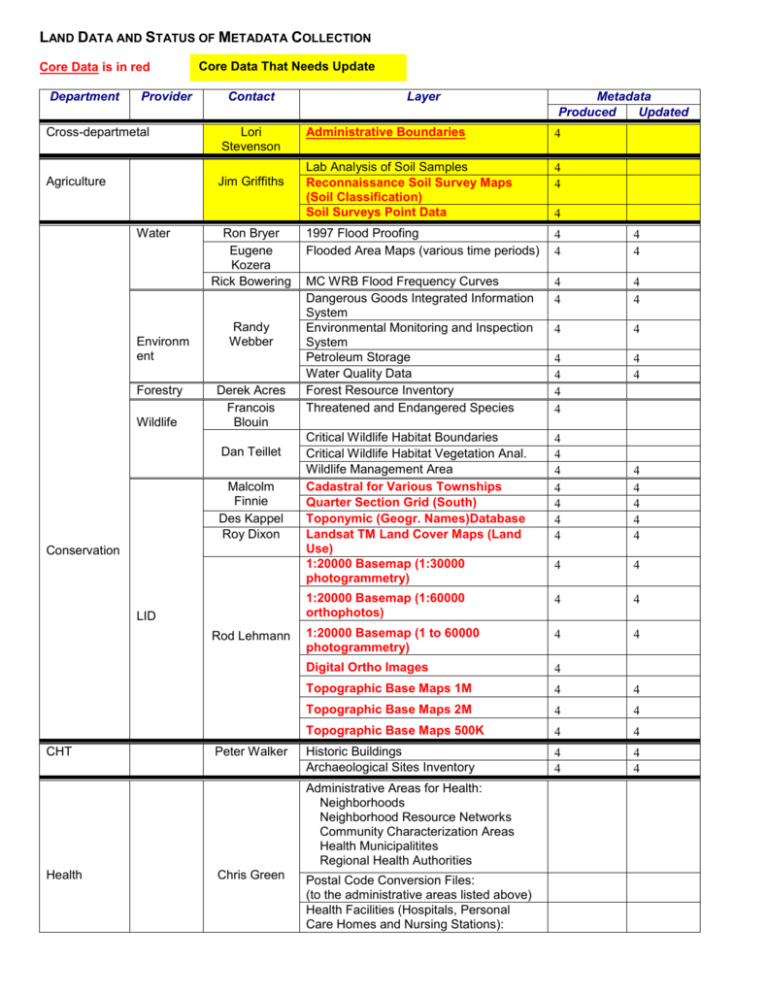
LAND DATA AND STATUS OF METADATA COLLECTION Core Data is in red Department Provider Core Data That Needs Update Contact Cross-departmetal Lori Stevenson Agriculture Jim Griffiths Water Environm ent Forestry Wildlife Ron Bryer Eugene Kozera Rick Bowering Randy Webber Derek Acres Francois Blouin Dan Teillet Malcolm Finnie Des Kappel Roy Dixon Conservation LID Rod Lehmann CHT Peter Walker Layer Administrative Boundaries Lab Analysis of Soil Samples Reconnaissance Soil Survey Maps (Soil Classification) Soil Surveys Point Data 1997 Flood Proofing Flooded Area Maps (various time periods) MC WRB Flood Frequency Curves Dangerous Goods Integrated Information System Environmental Monitoring and Inspection System Petroleum Storage Water Quality Data Forest Resource Inventory Threatened and Endangered Species Critical Wildlife Habitat Boundaries Critical Wildlife Habitat Vegetation Anal. Wildlife Management Area Cadastral for Various Townships Quarter Section Grid (South) Toponymic (Geogr. Names)Database Landsat TM Land Cover Maps (Land Use) 1:20000 Basemap (1:30000 photogrammetry) 1:20000 Basemap (1:60000 orthophotos) 1:20000 Basemap (1 to 60000 photogrammetry) Digital Ortho Images Topographic Base Maps 1M Topographic Base Maps 2M Topographic Base Maps 500K Historic Buildings Archaeological Sites Inventory Administrative Areas for Health: Neighborhoods Neighborhood Resource Networks Community Characterization Areas Health Municipalitites Regional Health Authorities Health Chris Green Metadata Produced Updated Postal Code Conversion Files: (to the administrative areas listed above) Health Facilities (Hospitals, Personal Care Homes and Nursing Stations): Highways Dan Buhler Housing Housing Interg. Affairs Tracy Jackson Tannis Bohn Geological Services Paul Lenton IT&M Mines Mike Fedak Bridge and Culvert Openings Provincial Highways Map Raised Pads Road Alignment and Elevations Road Inventory Transportation Network Map Property Inventory Assessment Database Geology 1:1,000,000 Map Coverages Mining Claims System Quarry System Mining Assessment System Bedrock Geology Quaternary Geology Geochemistry Geochronology Geophysics Mineral Disposition Assessment Mineral Claims/Leases/Quarry Leases Mineral Deposits Aggregate Industrial Minerals Stratigraphy Hydrology MB Oil and Gas Well Information System


