BirdLife International Aquatic Warbler Conservation Team
advertisement
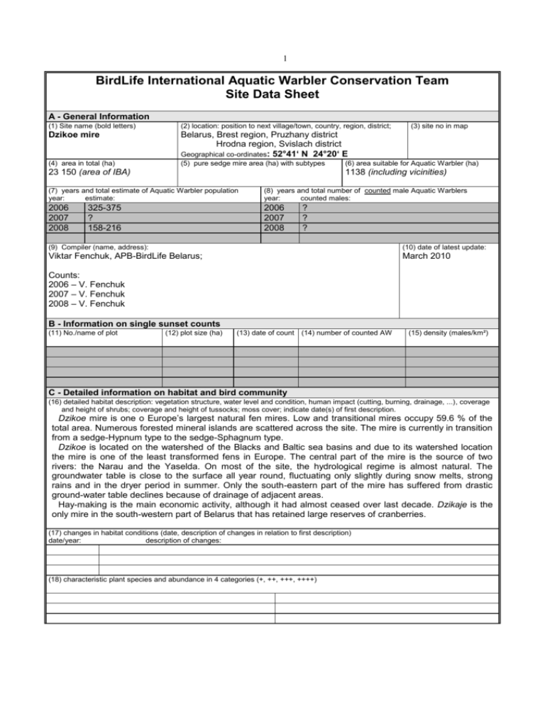
1 BirdLife International Aquatic Warbler Conservation Team Site Data Sheet A - General Information (1) Site name (bold letters) (2) location: position to next village/town, country, region, district; Dzikoe mire Belarus, Brest region, Pruzhany district Hrodna region, Svislach district Geographical co-ordinates: 52°41‘ N 24°20‘ E (4) area in total (ha) (5) pure sedge mire area (ha) with subtypes 23 150 (area of IBA) (3) site no in map (6) area suitable for Aquatic Warbler (ha) 1138 (including vicinities) (7) years and total estimate of Aquatic Warbler population year: estimate: (8) years and total number of counted male Aquatic Warblers year: counted males: 2006 2007 2008 2006 2007 2008 325-375 ? 158-216 ? ? ? (9) Compiler (name, address): (10) date of latest update: Viktar Fenchuk, APB-BirdLife Belarus; March 2010 Counts: 2006 – V. Fenchuk 2007 – V. Fenchuk 2008 – V. Fenchuk B - Information on single sunset counts (11) No./name of plot (12) plot size (ha) (13) date of count (14) number of counted AW (15) density (males/km²) C - Detailed information on habitat and bird community (16) detailed habitat description: vegetation structure, water level and condition, human impact (cutting, burning, drainage, ...), coverage and height of shrubs; coverage and height of tussocks; moss cover; indicate date(s) of first description. Dzikoe mire is one o Europe’s largest natural fen mires. Low and transitional mires occupy 59.6 % of the total area. Numerous forested mineral islands are scattered across the site. The mire is currently in transition from a sedge-Hypnum type to the sedge-Sphagnum type. Dzikoe is located on the watershed of the Blacks and Baltic sea basins and due to its watershed location the mire is one of the least transformed fens in Europe. The central part of the mire is the source of two rivers: the Narau and the Yaselda. On most of the site, the hydrological regime is almost natural. The groundwater table is close to the surface all year round, fluctuating only slightly during snow melts, strong rains and in the dryer period in summer. Only the south-eastern part of the mire has suffered from drastic ground-water table declines because of drainage of adjacent areas. Hay-making is the main economic activity, although it had almost ceased over last decade. Dzikaje is the only mire in the south-western part of Belarus that has retained large reserves of cranberries. (17) changes in habitat conditions (date, description of changes in relation to first description) date/year: description of changes: (18) characteristic plant species and abundance in 4 categories (+, ++, +++, ++++) 2 (19) other bird species observed (give numbers of breeding pairs and abundance in bp/km², if possible) bird species number abundance bird species Aquila chrysaetos Aquila clanga Aquila pomarina Tetrao tetrix(courting males) Circus aeruginosus Grus grus Crex crex Gallinago gallinago 1 4-5 11-12 60-80 30-60 30-40 50-100 Gallinago media (courting males) Limosa limosa Numenius arquata Bubo bubo Strix nebulosa Locustella naevia Anthus pratensis number abundance 20 30-50 40-80 2 2-3 400-700 30004000 800-1000 other animal species observed: Lynx lynx (Lynx) Alces alces (Elk) Bison bonasus (Bison) D - Threats and protection status (21) legal protection status: 92 % of territory of the mire is included into the territory of the NP “Belavezhskaia pushcha”. (22) description of threats: Cessation of hay-making on the mire is the major threat. Availability of easily accessible hay fields on adjacent drained areas has lead to abandonment of previously divided among local peasants and intensively cut territories of the open mire. This allows shrubs to encroach on the open fens, decreasing the suitable breeding area for the AW. Incorrect exploitation of the existing drainage facilities around Dzikoe mire influences the hydrological regime of the eastern part of the mire, accelerating plant successions in the affected area. It is now being overgrown by bushes and forests and in dry years there is also a threat of fires. The network of drainage canals built in the end of XIX century and straightening of Narau river also have draining effect on the mire resulting in lowering of the water table and acceleration of process of transformation from eutrophic to mezotrophic. stage of mire development (23) conservation action needed: Work out a project of territorial structuring of Dzikoe wetland as an ecologically and economically viable base for proper land-use (including recreation). Organize proper management of hydrological regime of Dzikoe mire to support stable functioning of mire ecosystems, conservation of fens and biological diversity. To achieve this it is needed to remove unauthorized drainage systems; minimize the impact of Yaselda drainage system and Dzikoe peat excavation site. Organize monitoring of water level and quality; flora and plant communities, biotopes, populations of the Aquatic warbler, other bird species and fauna for constant evaluation of the state of mire ecosystems and adjustment of the implementation of the management plan of the mire. Develop GIS and mathematical models for ecosystems monitoring of Dzikoe mire. Implement programmes for local population on raising awareness of the value of the mire and importance of conservation measures, work with schools and mass-media.
