A cruise from Houma, Louisiana to Sanibel Island
advertisement
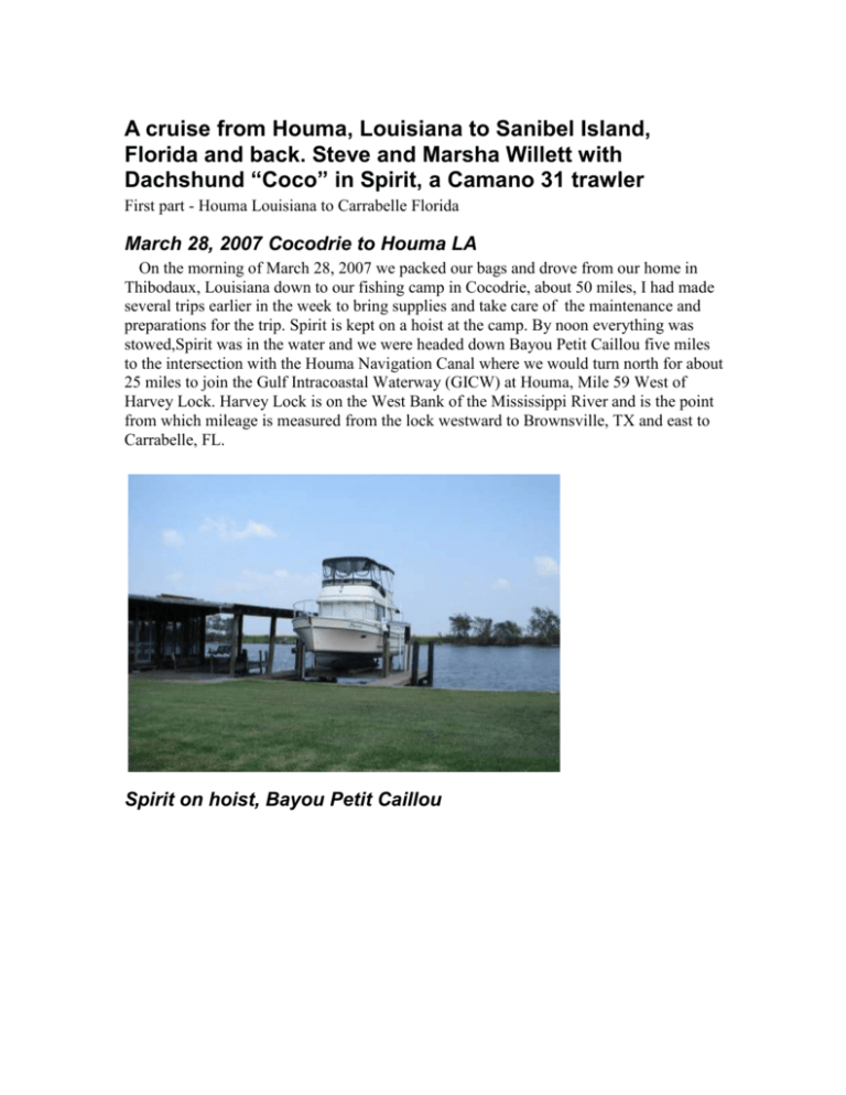
A cruise from Houma, Louisiana to Sanibel Island, Florida and back. Steve and Marsha Willett with Dachshund “Coco” in Spirit, a Camano 31 trawler First part - Houma Louisiana to Carrabelle Florida March 28, 2007 Cocodrie to Houma LA On the morning of March 28, 2007 we packed our bags and drove from our home in Thibodaux, Louisiana down to our fishing camp in Cocodrie, about 50 miles, I had made several trips earlier in the week to bring supplies and take care of the maintenance and preparations for the trip. Spirit is kept on a hoist at the camp. By noon everything was stowed,Spirit was in the water and we were headed down Bayou Petit Caillou five miles to the intersection with the Houma Navigation Canal where we would turn north for about 25 miles to join the Gulf Intracoastal Waterway (GICW) at Houma, Mile 59 West of Harvey Lock. Harvey Lock is on the West Bank of the Mississippi River and is the point from which mileage is measured from the lock westward to Brownsville, TX and east to Carrabelle, FL. Spirit on hoist, Bayou Petit Caillou Shrimp boats in Cocodrie We usually travel 8.5 to 9 Statute miles per hour traveling at this speed will give us close to 3 MPG. Most of our travel is done on the ICW which is measured in statute miles, so I find it more convenient to work in St. Miles rather than Nautical Miles and Knots. We were able to pass through the pontoon and the swing bridges on Houma Navigation Canal without much delay, on the way we saw one single and then a pair of beautiful Bald Eagles. Not far from the junction with the GICW I felt a lurch and then the prop vibrating, we were trailing what seemed to be a red blanket or tarp in the prop wash I stopped and reversed the transmission several times and it came off. Thank God, a swim to clear the prop or more likely a call for a diver would not have been the way to start the trip. We continued on to the Intracoastal and through Houma and were tied up at the city marina by 4 PM. The marina is just off the waterway and next to a small park. We often spend the first night of a trip at the Houma marina on the GICW to avoid getting caught up in the rush hour bridge curfews on the way up in the morning. The City Marina is small it has electric service, water, and pumpout the folks are very nice and helpful. It is located close to downtown and several very good restaurants. Marsha’s parents live not too far away so they came by and we went to “1921” a great seafood restaurant for a goodbye dinner with them. Distance traveled today 30 miles. Friday, March 29 Houma to Harvey LA I picked up breakfast to go at the cafeteria of the hospital next to the marina, the food there is quite good, and we were on our way East by 8AM. The weather was fine and traffic not too heavy along the Intracoastal. Most of the way the GICW is cut through undeveloped areas so there is lot of wildlife; nutria, turtles, birds and the occasional alligator swimming in the canal or sunning himself on the bank. Coastal Louisiana is an important oil and seafood producer in the developed areas there is a lot of service infrastructure and fabrication yards for oil field vessels and the equipment supporting offshore drilling and production. There is also an abundance of seafood related activity, shrimp, oyster, and crab boats are plentiful along with unloading and processing plants. An Oil Industry Vessel nears completion in Larose, La. Mid afternoon we stopped in Lafitte, Mile 15 WHL, at the Fleming Canal Store fuel dock where we filled up with diesel. There is a bulkhead next to the store where it is possible to tie up for the night, no services. Once fueled up we continued to mile 5 where we moored at a bulkhead on the ICW levee next to the parking lot of the Boomtown Casino in Harvey, LA. This is a rough (good fenders required) but well located spot to stay when Eastbound, it is only 5 miles to the Harvey Lock so you can get an early start across the Mississippi and New Orleans the next day. Once the boat is well secured one can just walk a hundred yards or so to the casino for something to eat and drink or gamble a bit if you like. I try to make the New Orleans crossing on a weekend whenever possible because most of the bridges have curfews and will not open during weekday morning and evening rush hour traffic, this usually adds to the delays at the bridges and lock. Distance today 55 miles Spirit Secured near Boomtown Casino Friday March 30, 2007 Harvey LA to Pass Christian MS We left Boomtown at 7AM and were in the Harvey lock at 8 AM with a “Light Boat” this is a push boat with no barges. The Harvey Lock has pins set into the walls, boats are directed to the wall and you loop a line over one of the pins. You need to hold it so you can pay put line or take up slack as the water level changes. Once all the boats are secured the doors close and if you are Eastbound the water rises 3 to 6 feet depending on the river height. Once the level is reached the doors open to the river and you travel down stream about 5 miles to the Industrial Canal Lock to leave the river. Once in the river you are directed to call Vessel Traffic Control, pleasure boats are usually just told watch out for traffic and to proceed. The downstream run will bring you past the New Orleans Riverfront, Jackson Square and other nice scenery. Sadly there is no place for pleasure craft to tie up along the way. We made good time, almost 11 MPH downstream, of course we’ll have to pay the piper going upstream on the return trip! New Orleans Riverfront We made it through the Industrial Lock and were lowered back into the GICW along with a tow with two barges and one light boat by 10:15 AM. That is very good time, some friends were delayed over ten hours making the same crossing a couple of months ago due to a bridge problem. On most of my transits I have usually had to wait of 30 to 45 minutes at each lock, much longer waits are not unusual. The locks near New Orleans use VHF channel 14, when locking it is very important to pay close attention to, and follow, the Lockmaster’s instructions. Ask for clarification if you are not sure about something, they are usually very accommodating but are used to dealing with commercial traffic who have done this many times and know just what is going on. A tow leaving the Industrial Lock Eastbound By midday the wind had picked up and it was blowing pretty strong, 15-20 MPH, for the next 30 miles we would be in the protected waters of the canal. There is still a lot of damage hurricane damage evident in this area. The levees are being repaired and there are huge piles of debris from the cleanup, acres of what the cleanup companies call white goods ie. refrigerators and stoves. Sunken boats or boats pulled off of the banks are loaded onto barges for disposal. I’m not sure what they do with the boats in the end. Want to buy a project boat? Cheap! When we got to the Rigoletts, Mile 35 East of Harvey Lock, we were in open water and it was quite rough. We decided to proceed and if got too uncomfortable we would return and anchor for the night at nearby Rabbit Island, a fairly well protected anchorage. After a few miles the wind wasn’t getting any worse so we proceeded on to Pass Christian, MS. On Spirit we carry the dinghy, a 9 foot Watertender, tied across the stern. Usually this works fine but in these conditions it got knocked off of the swim platform by the waves. I got it bailed out and back in position, about half an hour later it was knocked off again! I fitted a line to the bow of the dinghy and towed it the rest of the way. It was an uncomfortable trip but we had no other problems. At 4:30 PM we entered what H. Katrina has left of Pass Christian Small Craft Harbor. About 80% of the docks are destroyed, only some of the pilings remain, there is no electricity, water, or other service available. Destroyed docks, Pass Christian We squeezed into one of the few remaining slips and got everything secured the wind was quite strong now forecast 15- 20 K all night and all day April 1 so we spent the day rocking and rolling in the marina. The Harbormaster was very nice and offered to drive us to a restaurant but we had food on board so stayed put the whole day. He told me the City of Pass Christian has plans to make a new pleasure boat harbor just east of the existing facility which is now shared by commercial and pleasure boats. If that does come to be it will be very convenient for boats cruising this area. One of the few remaining docks, Pass Christian Harbor 62 Miles today. Sunday April 1, 2007 April Fool’s Day, figured it would truly be foolish to be out in the 15- 20 K winds so spent the day in the marina. I found it strange how several guys felt they just had to take their families out on the water on a day like this. We saw a couple of 17- 19 foot runabouts towed back into the harbor, both with young children on board. 0 Miles today Monday April 2, 2007 Pass Christian to Dauphin Island Al. The weather is fine today we left Pass Christian at 8 AM heading East in the Mississippi Sound. The sound is semi protected by a chain of barrier islands about 5 miles from the mainland. Today the water is quite calm we are cruising along at 9 MPH and burning just over 3 GPH according to the flow meter. We cross the Pascagoula MS Ship Channel at 1PM and keep headed East for Dauphin Island. Apparently Dauphin Island caters mainly to Spring Breakers and Sportfishermen, I had never been there before so am not too familiar with it. It would be a reasonable stop for someone wanting to overnight in a marina in the area without going up Mobile Bay. Tow with Coal barges in MS Sound At 4:30 we arrive at Dauphin Island Marina no one is around so we find a spot to tie up at the fuel dock. A 30 amp outlet is nearby so we have electricity for the night. There is a casual seafood restaurant, Barnacle Bill’s, next to the marina and we have a good dinner there. 71 miles today Tuesday April 3, 2007 Dauphin Island to The Wharf Marina at ICW mile 158 EHL We fuel up and settle our bill at the marina office and head out East, Dauphin Island marina is a bit out of the way but fortunately has two entrances, one to the East and another to the West, both are kind of meandering and narrow in some spots but well marked and save back tracking when leaving. We passed a large Coast Guard installation, and Fort Gaines, built in 1861 and used by the Confederacy during the Civil War. During WWII Fort Gaines served as a base to search for German submarines prowling in the Gulf of Mexico. Fort Gaines, built in 1861, on Dauphin Island Leaving Dauphin Island we crossed Mobile Bay in a light chop, the bay is large and shallow and can get rough when the wind is blowing. We entered the GICW canal at Bon Secour Bay on the South Eastern shore of Mobile Bay. Stopped for lunch at Lulu’s Homeport Marina and restaurant, mile 155 EHL, Lulu is Jimmy Buffett’s sister. The Homeport development is very nice, the Marina has fuel, floating docks and the restaurant, which overlooks the waterway, is a fun place. It is often crowded but the drinks and food are very good. Lulu’s Homeport Marina and restaurant After lunch it was a short trip to The Wharf at mile 158 EHL. The Wharf is a huge development right on the Intracoastal, it has a marina, condominiums with slips, shopping and office center, and an amusement park with a Huge Ferris wheel. The development is not complete yet, the Marina office was in a trailer, the Harbor master said the office, baths, and laundry would be complete in 60 days. We didn’t stop there on our return trip about 70 days later but it did look like they were done! There are several large developments, condos and condos with slips along this stretch of the waterway. We met friends from Louisiana at The Wharf, they are moving their 36’ Grand Banks from Slidell, LA to Charleston where he will be working, he is concerned about the water levels in Lake Okeechobee it seems they will be too shallow to allow crossing to the East coast. We had drinks with them then dinner on board. 30 miles today Wednesday April 4, 2007 The Wharf Marina to Palafox Marina, Pensacola We continued along the GICW towards Pensacola, passing by Ingram Bayou a beautiful and well protected anchorage. We stayed there last year and enjoyed it, there was a lot of jet ski traffic when we first got there but they left by mid afternoon and it became very peaceful. The Pensacola Lighthouse We arrived at Palafox Marina at noon, Palafox is a very nice modern marina, complete with floating docks, clean restrooms, showers and laundry facility. The downtown area is close by and has several bars and good restaurants nearby. Palafox Marina, offices and apartments in the background The downtown area is still rebuilding from recent Hurricanes and there are still areas where some of the shops are closed. The National Museum of Naval Aviation is located in Pensacola, it will take a cab ride to get there from the marina but it is well worth visiting. 31 miles today Thrusday April 5, 2007 It was cool and windy so we stayed at the marina I did some waxing on the boat and found a better way to secure the dinghy on the swim platform. We took a cab to Walmart, wow! I haven’t been to one in a whole week. I have some fishing rods on the boat so I bought a Florida nonresident license, $31.00 for fresh and saltwater for a year not a bad price. Back at the marina we ordered dinner delivered from a Mexican restaurant and ate on board. 0 miles today Friday April 6, 2007, Good Friday, Pensacola to Ft. Walton We left Palafox at 10 AM it was 52 degrees and winds about 17 MPH. There was a strong east current which helped us along we were traveling 10 mph and only burning 2.5 GPH. We were in protected water of the Santa Rosa Sound the whole time so even though the wind was blowing there was only a light chop. Sugar white sand and pine trees along the Sound We arrived at the Boat Marina at 2:30 PM I radioed the marina for a slip but the harbormaster was away, I was told to just pick and empty one and pull in there. So I did, this marina has suffered a lot of hurricane damage the owner is in the process of getting it back in shape. The slips and baths are kind of rough but it is an interesting place and the folks running it are nice. Power and water were available but no diesel. It can be bouncy depending on the wind direction. 31 miles today Saturday April 7, 2007 Ft. Walton to Anchorage at bridge at mile 250 EHL. We left The Boat Marina at 11:00 AM the temperature last night got down to 39 degrees! Stopped for diesel at Brooks Bridge Marina took on 44 gallons. Then we entered Choctawhatchee Bay the wind was about 15K from the west. At 3:30 we anchored on the northeast side of the approach to the Hwy 83/331 Bridge at GICW mile 250 EHL we were in about 6’ of water and the earthen ramp to the bridge blocked the west wind. When I dinghied Coco ashore for his walk near the highway a guy in a pickup towing an airboat saw me in my lifejacket and stopped, he though Spirit was aground and offered to pull us off in his air boat. That was very nice of him I hope if, or when, I go aground someday a Good Samaritan like him will be around to help. 25 miles today Sunday April 8, 2007 Easter Sunday Mile 250 anchorage to Panama City Marina Woke up this morning and brought Coco ashore no sooner we got back on the boat it started raining and sleeting I didn’t have an outside thermometer but it was Cold! At 7:30 we secured the dinghy and pulled in the anchor and made the trip to Panama City driving from the warmer lower helm. We arrived at the Panama City Marina and were assigned a slip near the fuel dock and marina office. The marina has a fuel, ships store, clean baths, and laundry facility. It is near the downtown area with quite a few good shops and restaurants within walking distance. There is a grocery store not too far away but it is a long walk. Panama City Marina Slips 39 miles today Monday April 9, 2007 Spent day the at Panama City Marina I walked about 8 blocks to a good marine supply store called, I think, Panama City Marine Supply they are well stocked with all sorts of marine goods and hardware.We had dinner at the Caspian Café a Middle Eastern restaurant not far from the marina, the food was very good. 0 Miles today Tuesday April 10, 2007 Panama City to Scipio Creek Marina, Apalachicola We left Panama City at 7:15 the wind was not too bad and the water was nice. We proceeded to East Bay passing by one of the large wood pulp plants in the area it was interesting to see the huge piles of pine logs and the cranes which feed them into the mill to be chipped and ground into pulp for paper and other products. Paper mill East of Panama City At mile 312 EHL the waterway enters Wettapoo Creek and becomes a canal again, most of this portion of the waterway was dug through pine forest. The banks are about 15 feet high and quite steep this stretch is sometimes referred to as the Grand Canyon. The waterway is narrow here there is not a lot of commercial traffic but one needs to pay attention to the VHF radio, the tows will usually announce when they are approaching a sharp bend. Always give them lots of room. The “Grand Canyon” A section of the waterway near Apalachicola On the stretch between Panama City and Apalachicola the time changes from Central to Eastern time, we arrived at Scipio Creek Marina at 3:45 This is a family run marina the folks are friendly they have all the services one could need including a good seafood restaurant, Papa Joe’s, it can be crowded, lots of the locals eat here, a good sign! Appalachicola bills itself as an oyster capital and there are lots of places serving them raw on the half shell, or cooked any way you can imagine. We took a walk downtown, lots of nice shops and restaurants and a lot of construction (condos) going on as is the case in most of these towns near the water! Dinner at Papa Joe’s 62 miles today Wednesday April 11, 2007 Apalachicola to Carrabelle Departed Scipio Creek Marina at 7:30 it was overcast and the winds were light in the St. Georges Sound. As we passed under the St. Georges Island Bridge there were several oyster harvesters working with tongs and bringing oysters up into their skiffs. It is a different system from oyster harvesting in Louisiana where large boats drag a dredge rake which gathers the oysters up from the bottom. Oyster harvesters at work. We arrived at the Moorings Marina in Carrabelle at 11:15 we were met by Buddy, the “Weather Guru” at the Marina we fueled up and were given a slip. There is a motel at the marina, it is “dog friendly” so we took a room for the night so we could have a real shower for a change. Later in the afternoon I spoke with Buddy who had checked the latest weather reports and felt that things should be ok for our crossing to Steinhatchee in the morning. He did ask that we check with him early in the morning before leaving in case there was any change in the forecast. We turned in early and got a good night’s sleep I think Coco especially enjoyed a night’s sleep without rocking! 30 miles today
