Erosion and Deposits
advertisement

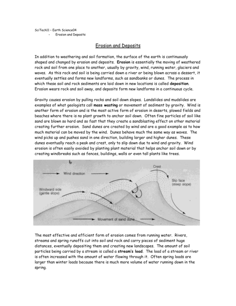
SciTech11 – Earth Science04 - Erosion and Deposits Erosion and Deposits In addition to weathering and soil formation, the surface of the earth is continuously shaped and changed by erosion and deposits. Erosion is essentially the moving of weathered rock and soil from one place to another, usually by gravity, wind, running water, glaciers and waves. As this rock and soil is being carried down a river or being blown across a dessert, it eventually settles and forms new landforms, such as sandbanks or dunes. The process in which these soil and rock sediments are laid down in new locations is called deposition. Erosion wears rock and soil away, and deposits form new landforms in a continuous cycle. Gravity causes erosion by pulling rocks and soil down slopes. Landslides and mudslides are examples of what geologists call mass wasting or movement of sediment by gravity. Wind is another form of erosion and is the most active form of erosion in deserts, plowed fields and beaches where there is no plant growth to anchor soil down. Often fine particles of soil like sand are blown so hard and so fast that they create a sandblasting effect on other material creating further erosion. Sand dunes are created by wind and are a good example as to how much material can be moved by the wind. Dunes behave much the same way as waves. The wind picks up and pushes sand in one direction, building larger and higher dunes. These dunes eventually reach a peak and crest, only to slip down due to wind and gravity. Wind erosion is often easily avoided by planting plant material that helps anchor soil down or by creating windbreaks such as fences, buildings, walls or even tall plants like trees. The most effective and efficient form of erosion comes from running water. Rivers, streams and spring runoffs cut into soil and rock and carry pieces of sediment huge distances, eventually depositing them and creating new landscapes. The amount of soil particles being carried by a stream is called a stream’s load. The load of a stream or river is often increased with the amount of water flowing through it. Often spring loads are larger than winter loads because there is much more volume of water running down in the spring. Water is affected by gravity and will always run downhill or settles in the lowest possible location. Often the lowest location is the ocean and because of this, larger drainage systems allow for water to be funneled down from the highest peaks in British Columbia, all the way down to the Pacific Ocean. The total area drained by a major river and its channels is called a drainage basin. Drainage basins that are separated by large landmasses (such as mountains) are called divides. The largest divide in North America is called the Continental Divide. The Continental Divide splits the continent into two halves. All water to the west of the divide ends up in the Pacific, all water to the east, in the Atlantic. As streams and rivers flow they pick up and deposit new materials. Often they meander, curving and winding through the land sometimes even creating loops. A river will generally erode material on the outside of a curve because that is where the water is fastest and most forceful. Material is then deposited on the inside of a curve where the current is weaker. As the water wears away at a bank it can sometime create loops. More sediment, creating what is called an Oxbow Lake eventually seals off these loops. Here is an example of how an Oxbow Lake is formed. A bend in a river is eventually squeezed together until an loop is formed. The flow around the new island is slower resulting in sediment deposits on two ends. These end eventually build up and seal off the lake and the river continues on its own in a straight line. When the water from a river reaches a large body of water like Shuswap Lake or the Pacific Ocean, the flow is dramatically reduced. This causes the deposition of sediment into what is called a delta. Often deltas are changing; new sandbanks are created which change the direction of flow, which in turn affects the deposits of new sediment materials. During spring runoffs it is not uncommon to see small river deltas, like the one at the mouth of the Shuswap River and Mara Lake, change shape over night. Glaciers and waves are two other forms of eroding forces. The glacier is a large mass of moving ice and snow. These glaciers contain so much water and weigh so much, that they can literally carve their way through solid rock. As a glacier moves through a valley, rock material of all sizes, from immense boulders to tiny particles of clay are carried along and pushed in front of it. All of this makes up the glacier’s load. When the lower end of a glacier reaches a warm area, the ice at the front begins to melt. The glacier will still move forward, but because it is melting faster than it is moving forward, it will appear to be shrinking. Geologists call this a retreating glacier. As this glacier retreats, it often deposits its load of rocks and sediment materials. Glaciers that make their way to the ocean often break off in chunks creating icebergs. These icebergs still carry their loads of rock material and as they melt these rocks are deposited on the ocean floor, often thousands of kilometers from where it was originally picked up. Waves are one of the most common and most power eroding forces on the planet. Waves are caused by wind, tides or even earthquakes (remember tsunamis?) and because they are often constant, they are consistently eroding and changing the shape of the shore. Waves cause erosion in several ways. As ocean waves reach shallow water, they begin to break. As the breaking waves hit the shoreline, their force knocks fragments off existing rock formations. Waves also carry small rocks and sand which only add to the effect of the waves crashing on rocks. The waves can also force water into cracks in the shore, breaking it up with more pressure. Although waves will typically erode up to 1 to 1 ½ metres of shoreline a year, storms and other freak occurrences have been know to erode up to 25 meteres in one day. Eroded rock particles deposited on the shoreline form beaches. Beaches consists of fine sand or of large pebbles that have come from nearby areas or they have been formed from sediment from large rivers. Sand from beaches and deltas can also be shaped into sandbars or spits by the movement of waves. Sandbars are long underwater ridges of sand. If those ridges are connected to the shore, they are then called spits. Sandbars can be found all along the coast and just about anywhere a river or large stream enters a large body of water. There are large sandbars and spits located on Shuswap Lake, most notably in between Eagle River and the Sicamous Narrows. Houseboats in this area are directed to stay clear of these sandbars because they can become stuck quite easily. Whether by gravity, wind, running water, glaciers or waves, erosion and deposits are constantly changing the shape of the land and the shoreline we live on. SciTech11 – Earth Science04 - Erosion and Deposits Erosion and Deposits 1. Vocabulary – Use your readings, a dictionary, a textbook or an encyclopedia to provide definitions for the following terms; Erosion Deposition Divide Stream’s Load Drainage Basin Oxbow Lake Delta 2. Answer the following questions using COMPLETE SENTENCES; a. In your own words, describe how wind erosion works. How can it be prevented? (2 mks for your description and quality of your explanation) b. How does a river “meander” and how can this “meandering” create a lake? (2 mks for quality of description and explanation) c. What is a “retreating glacier” and how do glaciers shape the land? (2 mks for quality of response and inclusion of details) d. In your own words describe what is the difference between a sandbar and a spit. How are they formed? (2 mks for quality of response and inclusion of details) 3. Check out the photo gallery section of the International Erosion Control Association (http://www.ieca.org/) or do an image search for photographic evidence of natural erosion. Copy an image onto a word document, label it and identify the website from which you found it and then describe what type of erosion your image depicts (is it a landslide, an Oxbow Lake, a glacier valley, etc…). You will receive 5 marks for your ability to find an image example of erosion and your ability to identify it and document where you found it. Total Marks: ____/ 20


