View/Open - Earth-Prints Repository
advertisement

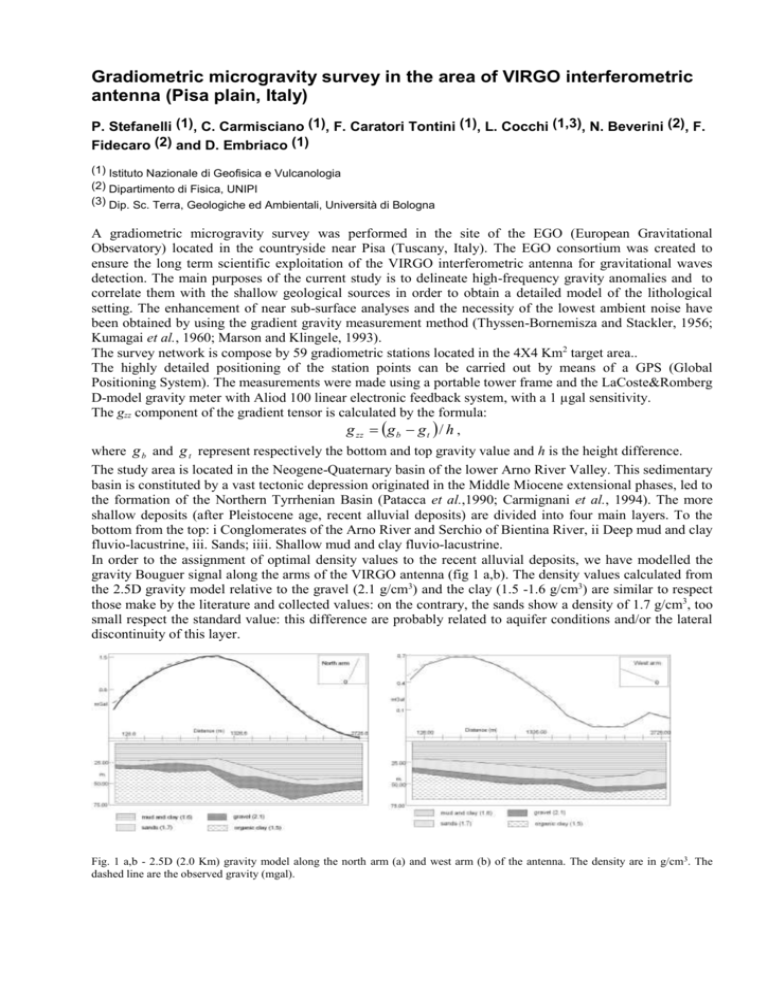
Gradiometric microgravity survey in the area of VIRGO interferometric antenna (Pisa plain, Italy) P. Stefanelli (1), C. Carmisciano (1), F. Caratori Tontini (1), L. Cocchi (1,3), N. Beverini (2), F. Fidecaro (2) and D. Embriaco (1) (1) Istituto Nazionale di Geofisica e Vulcanologia (2) Dipartimento di Fisica, UNIPI (3) Dip. Sc. Terra, Geologiche ed Ambientali, Università di Bologna A gradiometric microgravity survey was performed in the site of the EGO (European Gravitational Observatory) located in the countryside near Pisa (Tuscany, Italy). The EGO consortium was created to ensure the long term scientific exploitation of the VIRGO interferometric antenna for gravitational waves detection. The main purposes of the current study is to delineate high-frequency gravity anomalies and to correlate them with the shallow geological sources in order to obtain a detailed model of the lithological setting. The enhancement of near sub-surface analyses and the necessity of the lowest ambient noise have been obtained by using the gradient gravity measurement method (Thyssen-Bornemisza and Stackler, 1956; Kumagai et al., 1960; Marson and Klingele, 1993). The survey network is compose by 59 gradiometric stations located in the 4X4 Km2 target area.. The highly detailed positioning of the station points can be carried out by means of a GPS (Global Positioning System). The measurements were made using a portable tower frame and the LaCoste&Romberg D-model gravity meter with Aliod 100 linear electronic feedback system, with a 1 µgal sensitivity. The gzz component of the gradient tensor is calculated by the formula: g zz g b g t / h , where g b and g t represent respectively the bottom and top gravity value and h is the height difference. The study area is located in the Neogene-Quaternary basin of the lower Arno River Valley. This sedimentary basin is constituted by a vast tectonic depression originated in the Middle Miocene extensional phases, led to the formation of the Northern Tyrrhenian Basin (Patacca et al.,1990; Carmignani et al., 1994). The more shallow deposits (after Pleistocene age, recent alluvial deposits) are divided into four main layers. To the bottom from the top: i Conglomerates of the Arno River and Serchio of Bientina River, ii Deep mud and clay fluvio-lacustrine, iii. Sands; iiii. Shallow mud and clay fluvio-lacustrine. In order to the assignment of optimal density values to the recent alluvial deposits, we have modelled the gravity Bouguer signal along the arms of the VIRGO antenna (fig 1 a,b). The density values calculated from the 2.5D gravity model relative to the gravel (2.1 g/cm3) and the clay (1.5 -1.6 g/cm3) are similar to respect those make by the literature and collected values: on the contrary, the sands show a density of 1.7 g/cm3, too small respect the standard value: this difference are probably related to aquifer conditions and/or the lateral discontinuity of this layer. Fig. 1 a,b - 2.5D (2.0 Km) gravity model along the north arm (a) and west arm (b) of the antenna. The density are in g/cm3. The dashed line are the observed gravity (mgal). An anomaly negative pattern are shown in the gradient gravity map: the negative gravity anomaly seem related to the increase in depth of the layer of gravel - high layer density – that have detected by the geotechnical drillings along the orthogonal arms of the VIRGO antenna. Fig. 2 - Gradient gravity model of the gravel surface. The red lines represents the two orthogonal arms of VIRGO antenna. The dashed white lines are the boundaries of the palaeo-alluvial path. A gradient gravity model (fig. 2) has allowed to delineate the trending of the top surface of this layer. The NE-SW negative pattern should be to represent a palaeo-bed alluvial of the Lower Arno and Serchio of Bientina River system, related to the Late Pleistocene extensional tectonics in the Pisa Plain (Cantini et al., 2001). References Cantini P., Testa G., Zanchetta G. and Cavallini R.; 2001: The Plio-Pleistocene evolution of extensional tectonics in northern Tuscany, as constrained by new gravimetric data from the Montecarlo Basin (lower Arno Valley, Italy), Tectonophysics, 330, 25-43 Carmignani L., Decandia F.A., Fantozzi P.L., Lazzaretto A., Lotta D. and Meccheri M.; 1994: Tertiary extensional tectonics in Tuscany (northern Apennines Italy), Tectonophysics, 238, 295-315 Kumagai N., Abe E. and Yoshimura Y.; 1960: Measurements of the vertical gradient of gravity, Boll. Geof. Teor & Appl., 8, 607630. Marson I. and Klingele E. E.; 1993: Advantage of using the vertical gradient of gravity for 3-D interpretation, Geophysics, 58, 15881595. Patacca E., Sartori R. and Scandone P.; 1990: Tyrrhenian basin and Apenninic arcs: kinematics relations since late-Tortonian times, Mem. Soc. Geol. It., 45, 425-451. Thyssen-Bornemisza S. and Stackler W.F.; 1956: Observation of the vertical gradient of gravity in the field, Geophysics, 21, 771779.


