Historic Hazard Events for Barbados
advertisement
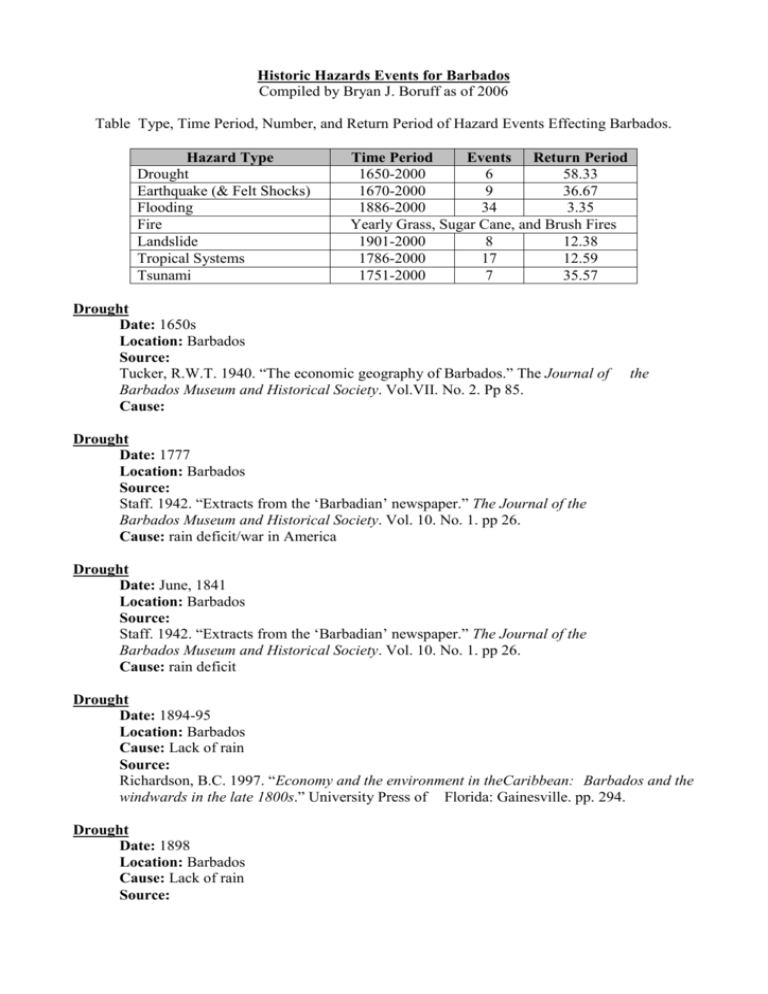
Historic Hazards Events for Barbados Compiled by Bryan J. Boruff as of 2006 Table Type, Time Period, Number, and Return Period of Hazard Events Effecting Barbados. Hazard Type Drought Earthquake (& Felt Shocks) Flooding Fire Landslide Tropical Systems Tsunami Time Period Events Return Period 1650-2000 6 58.33 1670-2000 9 36.67 1886-2000 34 3.35 Yearly Grass, Sugar Cane, and Brush Fires 1901-2000 8 12.38 1786-2000 17 12.59 1751-2000 7 35.57 Drought Date: 1650s Location: Barbados Source: Tucker, R.W.T. 1940. “The economic geography of Barbados.” The Journal of Barbados Museum and Historical Society. Vol.VII. No. 2. Pp 85. Cause: the Drought Date: 1777 Location: Barbados Source: Staff. 1942. “Extracts from the ‘Barbadian’ newspaper.” The Journal of the Barbados Museum and Historical Society. Vol. 10. No. 1. pp 26. Cause: rain deficit/war in America Drought Date: June, 1841 Location: Barbados Source: Staff. 1942. “Extracts from the ‘Barbadian’ newspaper.” The Journal of the Barbados Museum and Historical Society. Vol. 10. No. 1. pp 26. Cause: rain deficit Drought Date: 1894-95 Location: Barbados Cause: Lack of rain Source: Richardson, B.C. 1997. “Economy and the environment in theCaribbean: Barbados and the windwards in the late 1800s.” University Press of Florida: Gainesville. pp. 294. Drought Date: 1898 Location: Barbados Cause: Lack of rain Source: Richardson, B.C. 1997. “Economy and the environment in theCaribbean: Barbados and the windwards in the late 1800s.” University Press of Florida: Gainesville. pp. 294. Drought Date: 1978 Location: Barbados Cause: Lack of rain Source: Pelling, M. 2003. The vulnerability of cities: natural disasters and social resilience. Earthscan Publications LTD.: London. Pp 212. Hurricane Date: September, 1786 Location: Cause: Hurricane Source: Shephard, C. 1971. An historical account of the island of St. Vincent. Frank Cass and Company Limited: London. Pp 216. Hurricane Date: August 11, 1831 Location: Southern Parishes Cause: Hurricane Source: Staff. 1966. “The hurricane of August 1831.” The Journal of the Barbados Historical Society. Vol. 31, No. 4, pp 180-189. Museum Tropical System Date: September 8-9, 1875 Location: Barbados Cause: Tropical System Source: Inspector General’s Office. 1875. “Casualties.” The Times. Bridgetown: Barbados. Vol. 14(1706). September, 18. pp. 2. Tropical System Date: August 16, 1886 Location: Barbados Cause: Tropical System Source: Unsigned. 1886. “Letter to the Editor.” The Times. Bridgetown: Barbados. Vol. (2682). August, 18. pp. 2. 25 Hurricane Date: September 10, 1898 Location: Southern Parishes Cause: Hurricane Source: Staff. 1956. “Hurricane Janet at Barbados.” TheJournal of the Barbados Museum Historical Society. Vol. 23, No. 4, pp 153-164. AltSource: Richardson, B.C. 1997. “Economy and the environment in theCaribbean: Barbados and the windwards in the late 1800s.” University Press of Florida: Gainesville. pp. 294. Hurricane Date: September 9, 1931 Location: Barbados Cause: Hurricane Source: Caribbean Disaster Mitigation Project (CDMP). 1997. “Planning to mitigate the impacts of natural hazards in the Caribbean:Mitigation planning manual (Appendix: Natural Hazards in theCaribbean.).” Unit of Sustainable Development and Environment for the USAID Office of Foreign Disaster Assistance, and Organization of American States: Washington, D.C. pp 11. found at:http://www.oas.org/en/cdmp/publist.htm. found on: June 7th, 2004. Hurricane Date: August 31, 1949 Location: Barbados Cause: Hurricane Source: Staff. 1949. “Heaviest rains since 1898 push down bridge: houses swept away.” Barbados Advocate. Bridgetown: Barbados. Sept. 2. pp. 1-7. Hurricane Janet Date: September 22,1955 Location: Southern Parishes Cause: Hurricane Source: Watson, K. 2003. Barbados first: the years of change. Cole’s Printer Limited: Brigtown, Barbados. 204 pages. AltSource: CRED. 2004. “EM-DAT: the OFDA/CRED international disaster data base.” Center for Research on the Epidemiology of Disasters (CRED): Brussles: Belgium. Found on: April 8, 2004. Found at: http://www.em-dat.net/. AltSource: Staff. 1955. “Hurricane Janet.” Barbados Advocate.Bridgetown: Barbados. September, 23. pp. 1-4. AltSource: Staff. 1955. “Hurricane Janet.” Barbados Advocate. Bridgetown: Barbados. September, 24. pp. 1-5. AltSource: Staff. 1955. “Hurricane Janet.” Barbados Advocate. Bridgetown: Barbados. September, 27. pp. 5. AltSource: Staff. 1956. “Hurricane Janet at Barbados.” The Journal of the Barbados Museum Historical Society. Vol. 23, No. 4, pp 153-164. Hurricane Date: September 31, 1961 Location: Barbados Cause: Hurricane (Hattie) Source: Caribbean Disaster Mitigation Project (CDMP). 1997. “Planning to mitigate the impacts of natural hazards in the Caribbean:Mitigation planning manual (Appendix: Natural Hazards in theCaribbean.).” Unit of Sustainable Development and Environment for the USAID Office of Foreign Disaster Assistance, and Organization of American States: Washington, D.C. pp 11. found at:http://www.oas.org/en/cdmp/publist.htm. found on: June 7th, 2004. Hurricane Date: 1963 Location: Barbados Cause: Hurricane (Edith) Source: Poncelet, J.L. 1997. “Disaster Management in the Caribbean.” Disasters. Vol. 21(3). Pp 267-279 Hurricane Date: September, 1974 Location: Barbados Cause: Hurricane (Carmen) Source: Caribbean Disaster Mitigation Project (CDMP). 1997. “Planning to mitigate the impacts of natural hazards in the Caribbean:Mitigation planning manual (Appendix: Natural Hazards in theCaribbean.).” Unit of Sustainable Development and Environment for the USAID Office of Foreign Disaster Assistance, and Organization of American States: Washington, D.C. pp 11. found at:http://www.oas.org/en/cdmp/publist.htm. found on: June 7th, 2004. Hurricane Date: September, 1974 Location: Barbados Cause: Hurricane (Fifi) Source: Caribbean Disaster Mitigation Project (CDMP). 1997. “Planning to mitigate the impacts of natural hazards in the Caribbean:Mitigation planning manual (Appendix: Natural Hazards in theCaribbean.).” Unit of Sustainable Development and Environment for the USAID Office of Foreign Disaster Assistance, and Organization of American States: Washington, D.C. pp 11. found at:http://www.oas.org/en/cdmp/publist.htm. found on: June 7th, 2004. Hurricane Allen Date: August 4, 1980 Location: Barbados Cause: Hurricane Source CRED. 2004. “EM-DAT: the OFDA/CRED international disaster data base.” Center for Research on the Epidemiology of Disasters (CRED): Brussles: Belgium. Found on: April 8, 2004. Found at: http://www.em-dat.net/. AltSource: Staff. 1980. “Hurricane Allen.” Barbados Advocate. Bridgetown: Barbados. pp. 1-2. AltSource: August, 5. Staff. 1980. “No water of two days in north.” Barbados Advocate. Bridgetown: Barbados. August, 6. pp. 2-3. AltSource: Harris, M. 1980. “Chaos hits Careenage as 20 vessels sink.” Barbados Advocate. Bridgetown: Barbados. August, 5. pp. 1-3. AltSource: Harris, M. 1980. “Allen wrecks farm.” Barbados Advocate. Bridgetown: Barbados. August, 7. pp. 1. Tropical System Date: August 4, 1980 Location: Barbados Cause: Tropical System Source: Staff. 1980. “Storm causes damage.” Barbados Advocate. Bridgetown: Barbados. October, 6. pp. 1-2. AltSource: Staff. 1980. “Cleanup continues.” Barbados Advocate. Bridgetown: Barbados. October, 7. pp. 1. Tropical Storm Emily Date: September 20, 1987 Location: Barbados Cause: Hurricane Source CRED. 2004. “EM-DAT: the OFDA/CRED international disaster data base.” Center for Research on the Epidemiology of Disasters (CRED): Brussles: Belgium. Found on: April 8, 2004. Found at: http://www.em-dat.net/. AltSource: Staff. 1987. “Tropical storm Emily.” Barbados Advocate. Bridgetown: Barbados. September, 22. pp. 1-7. Hurricane Gabrielle Date: September 4, 1989 Location: arbados Cause: Hurricane Gabrielle Source: Vasco, P. 1989. “It’s too rough at Cattlewash.” Barbados Advocate. Bridgetown: Barbados. Sept. 5. pp 2-5. AltSource: Staff. 1989. “Clean-up time on east coast.” Barbados Advocate. Bridgetown: Sept. 6. pp 24. Hurricane Marylin Date: September 18, 1995 Location: Barbados Cause: Hurricane Source CRED. 2004. “EM-DAT: the OFDA/CRED international disaster data base.” Center for Research on the Epidemiology of Disasters (CRED): Brussles: Belgium. Found on: April 8, 2004. Found at: http://www.em-dat.net/. Barbados. Hurricane Lili Date: September 24, 2002 Location: Barbados Cause: Hurricane Source CRED. 2004. “EM-DAT: the OFDA/CRED international disaster data base.” Center for Research on the Epidemiology of Disasters (CRED): Brussles: Belgium. Found on: April 8, 2004. Found at: http://www.em-dat.net/. Earthquake: Date: 1670, 1674, 1675, 1690, 1700, 1702, 1720 Location: Barbados Cause: Earthquake Source Schomburgk, R.H. 1971. “The history of Barbados: comprising a geographical and statistical description.” Frank Cass and Company Limited: London. pp 722. Alt Source: USGS. 2003. “Earthquake hazards program: Earthquake search.” National Earthquake Information Center: Reston, VA. found on: April 10, 2004. http://neic.usgs.gov/neis/epic/epic.html. found at: Earthquake Date: December 23, 1816 Location: Barbados Cause: Source: Shephard, C. 1971. An historical account of the island of St. Vincent. Frank Cass and Company Limited: London. Pp 216. Earthquake: Date: 1953 Location: Barbados Cause: Earthquake (175 km North-west of St. Lucia) Source Seismic Research Unit. 2003. “Earthquakes.” University of West Indies: St Augustine, Trinidad Tobago. found on: April 11, 2004. found at: http://www.uwiseismic.com. Flood Date: August 15, 1886 Location: Barbados Cause: ? (probably a tropical system) Source: Farnum, F.C., and Narayan, K. 2004. “Personal communication, May20th.” Chief Hydrologist and Hydrologist. Caribbean Institute of Meteorology and Hydrology: Bridgetown, Barbados. Alt Source: Unsigned. 1886. “Letter to the Editor.” The Times. Bridgetown: Barbados. Vol. 25 (2682). August, 18. pp. 2. Flood Date: July 05, 1901 Location: Barbados Cause: ? (probably a tropical system) Source: Farnum, F.C., and Narayan, K. 2004. “Personal communication, May20th.” Chief Hydrologist and Hydrologist. Caribbean Institute of Meteorology and Hydrology: Bridgetown, Barbados. Flood Date: August 22, 1918 Location: South end of Island Cause: Tropical System Source: Skeete, C.C. 1934. “Weather observations and records in Barbados 1924-33.” The Journal of the Barbados Museum Historical Society. Vol. 1, No. 2, pp 115-136. Flood Date: Aug. 25, 1919 Location: Waterford District St. Michael Cause: Tropical System Source: Skeete, C.C. 1934. “Weather observations and records in Barbados 1924-33.” The Journal of the Barbados Museum Historical Society. Vol. 1, No. 2, pp 115-136. AltSource: Farnum, F.C., and Narayan, K. 2004. “Personal communication, May20th.” Chief Hydrologist and Hydrologist. Caribbean Institute of Meteorology and Hydrology: Bridgetown, Barbados. Flood Date: 1938 Location: Delamere Tenantry (between Halls Road and Constitution River)-now Queen Elizabeth Hospital Cause: Tropical Depression Source: Watson, K. 2003. Barbados first: the years of change. Cole’s Printer Limited: Bridgetown, Barbados. 204 pages. Flood Date: August 31, 1949 Location: Barbados Cause: Tropical System Source: Watson, K. 2003. Barbados first: the years of change. Cole’s Printer Limited: Bridgetown, Barbados. 204 pages. AltSource: Farnum, F.C., and Narayan, K. 2004. “Personal communication, May20th.” Chief Hydrologist and Hydrologist. Caribbean Institute of Meteorology and Hydrology: Bridgetown, Barbados. AltSource: Staff. 1949. “Heaviest rains since 1898 push down bridge: houses swept away.” Barbados Advocate. Bridgetown: Barbados. Sept. 2. pp. 1-7. AltSource: Staff. 1949. “Another flood victim found: damage May be $30,000 8 dead; 2 in hospital.” Barbados Advocate. Bridgetown: Barbados. Sept. 3. pp. 1-7. Flood Date: October 16, 1960 Location: St Andrew and St Thomas Cause: Thunderstorm Source: Staff. 1960. “Extracts from the Barbadian Newspaper.” The Journal of the Barbados Museum Historical Society. Vol. 28, No. 1, pp 17. Flood Date: October 22, 1960 Location: St Joseph (Frizer Plantation) Cause: Thunderstorm Source: Staff. 1960. “Extracts from the Barbadian Newspaper.” The Journal of the Barbados Museum Historical Society. Vol. 28, No. 1, pp 17. Flood Date: October 9, 1962 Location: Speightstown Cause: Heavy Rain Source: Staff. 1966. “Extracts from the Barbados Globe.” The Journal of the Barbados Historical Society. Vol. 30, No. 1, pp 47-48. Museum Flood Date: October 2, 1970 Location: Barbados Cause: Tropical Cyclone Source CRED. 2004. “EM-DAT: the OFDA/CRED international disaster data base.” Center for Research on the Epidemiology of Disasters (CRED): Brussles: Belgium. Found on: April 8, 2004. Found at: http://www.em-dat.net/. AltSource: Farnum, F.C., and Narayan, K. 2004. “Personal communication, May20th.” Chief Hydrologist and Hydrologist. Caribbean Institute of Meteorology and Hydrology: Bridgetown, Barbados. AltSource: Staff. 1970. “Millions of $$ Damage by Floods.” Barbados Advocate. Bridgetown: Barbados. October, 4. pp. 1-15. AltSource: Staff. 1970. “Heavy damage up North from floods” Barbados Advocate. Bridgetown: Barbados. October, 6. pp. 8-9. AltSource: Staff. 1970. “Downpour causes flooding” Barbados Advocate. Bridgetown: Barbados. October, 15. pp. 1. Flood Date: October 30, 1970 Location: Barbados Cause: ? (probably a tropical system) Source: Farnum, F.C., and Narayan, K. 2004. “Personal communication, May20th.” Chief Hydrologist and Hydrologist. Caribbean Institute of Meteorology and Hydrology: Bridgetown, Barbados. Flood Date: September 5, 1970 Location: Barbados Cause: very heavy rains Source: Staff. 1970. “Heavy flooding affects island.” Barbados Advocate. Bridgetown: September, 5. pp. 1-8. Barbados. Flood Date: 1975 (?) Location: Barbados Cause: ? (probably a tropical system) Source: Farnum, F.C., and Narayan, K. 2004. “Personal communication, May20th.” Chief Hydrologist and Hydrologist. Caribbean Institute of Meteorology and Hydrology: Bridgetown, Barbados. Flood Date: August 3, 1980 Location: Barbados Cause: ? (probably a tropical system) Source: Farnum, F.C., and Narayan, K. 2004. “Personal communication, May20th.” Chief Hydrologist and Hydrologist. Caribbean Institute of Meteorology and Hydrology: Bridgetown, Barbados. Flood Date: October 9, 1981 Location: Barbados Cause: ? (probably a tropical system) Source: Farnum, F.C., and Narayan, K. 2004. “Personal communication, May20th.” Chief Hydrologist and Hydrologist. Caribbean Institute of Meteorology and Hydrology: Bridgetown, Barbados. AltSource: Staff. 1981. “Wotton residents get complete wash-out.” Barbados Advocate. Bridgetown: Barbados. Oct. 11. pp. 1. AltSource: Staff. 1981. “Wotton families moved to Wildey.” Barbados Advocate. Bridgetown: Barbados. Oct. 12. pp. 1. Flood Date: October 1, 1984 Location: Barbados Cause: very heavy rains Source CRED. 2004. “EM-DAT: the OFDA/CRED international disaster data base.” Center for Research on the Epidemiology of Disasters (CRED): Brussles: Belgium. Found on: April 8, 2004. Found at: http://www.em-dat.net/. AltSource: Staff. 1984. “Three houses suffer damage.” Barbados Advocate. Bridgetown: Oct. 3. pp. 1. Barbados. Flood Date: October 31, 1984 Location: Barbados Cause: ? (probably a tropical system) Source: Farnum, F.C., and Narayan, K. 2004. “Personal communication, May20th.” Chief Hydrologist and Hydrologist. Caribbean Institute of Meteorology and Hydrology: Bridgetown, Barbados. AltSource: Staff. 1984. “Flooding in the north.” Barbados Advocate. Bridgetown: Barbados. Nov. 1. pp. 1. AltSource: Springer, J. 1984. “Residents tell about ‘night of fear.’” Barbados Advocate. Bridgetown: Barbados. Nov. 2. pp. 1. AltSource: Staff. 1984. “25 St. Peter families homeless.’” Barbados Advocate. Bridgetown: Barbados. Nov. 2. pp. 1. Flood Date: November 2, 1984 Location: Barbados Cause: ? (probably a tropical system) Source: Farnum, F.C., and Narayan, K. 2004. “Personal communication, May20th.” Chief Hydrologist and Hydrologist. Caribbean Institute of Meteorology and Hydrology: Bridgetown, Barbados. AltSource: Staff. 1984. “Damage continues – one death: roads flooded, walls tumble.’” Barbados Advocate. Bridgetown: Barbados. Nov. 3. pp. 1. AltSource: Brathwaite, J. 1984. “St Andrew hard-hit by flood waters.” Barbados Advocate. Bridgetown: Barbados. Nov. 3. pp. 1. AltSource: Scott, A. 1984. “Residents of flood area clean up shop.” Barbados Advocate. Bridgetown: Barbados. Nov. 4. pp. 1. AltSource: Staff. 1984. “$700,000 in road damage: government starts work on bridges.” Barbados Advocate. Bridgetown: Barbados. Nov. 5. pp. 1. Flood Date: October 19, 1985 Location: Barbados Cause: ? (probably a tropical system) Source: Farnum, F.C., and Narayan, K. 2004. “Personal communication, May20th.” Chief Hydrologist and Hydrologist. Caribbean Institute of Meteorology and Hydrology: Bridgetown, Barbados. Flood Date: Nov 11, 1985 Location: Barbados Cause: ? (probably a tropical system) Source: Farnum, F.C., and Narayan, K. 2004. “Personal communication, May20th.” Chief Hydrologist and Hydrologist. Caribbean Institute of Meteorology and Hydrology: Bridgetown, Barbados. AltSource: Phillips, W. 1985. “More St. Peter flooding: water as high as five feet.” Barbados Advocate. Bridgetown: Barbados. Nov. 12. pp. 1. AltSource: Staff. 1985. “Plan to tackle flooding: gov’t to dig 170 suck wells.” Barbados Advocate. Bridgetown: Barbados. Nov. 13. pp. 1. Flood Date: Nov 21, 1985 Location: Barbados Cause: ? Source: Farnum, F.C., and Narayan, K. 2004. “Personal communication, May20th.” Chief Hydrologist and Hydrologist. Caribbean Institute of Meteorology and Hydrology: Bridgetown, Barbados. AltSource: Staff. 1985. “St. Philip family face water problem” Barbados Advocate. Bridgetown: Barbados. Nov. 22. pp. 1. Flood Date: Sept 9, 1988 Location: Barbados Cause: tropical depression (50 miles north) Source: Farnum, F.C., and Narayan, K. 2004. “Personal communication, May20th.” Chief Hydrologist and Hydrologist. Caribbean Institute of Meteorology and Hydrology: Bridgetown, Barbados. AltSource: Staff. 1988. “Drenched!: Schools and offices closed, CERO sounds flood alert.” Barbados Advocate. Bridgetown: Barbados. Sept. 10. pp 1-2. AltSource: Staff. 1988. “Rains hampering water service.” Barbados Advocate. Bridgetown: Barbados. Sept. 12. pp 1. Flood Date: Sept 14, 1988 Location: Barbados Cause: ? (probably a tropical system) Source: Farnum, F.C., and Narayan, K. 2004. “Personal communication, May 20th.” Chief Hydrologist and Hydrologist. Caribbean Institute of Meteorology and Hydrology: Bridgetown, Barbados. Flood Date: October 18, 1988 Location: Barbados Cause: ? (probably a tropical system) Source: Farnum, F.C., and Narayan, K. 2004. “Personal communication, May20th.” Chief Hydrologist and Hydrologist. Caribbean Institute of Meteorology and Hydrology: Bridgetown, Barbados. AltSource: Austin, S. 1988. “Flooding, slippage as the rains come.” Barbados Advocate. Bridgetown: Barbados. Oct. 20. pp 3. Flood Date: September 4, 1989 Location: Barbados Cause: ? (probably a tropical system) Source: Farnum, F.C., and Narayan, K. 2004. “Personal communication, May 20th.” Chief Hydrologist and Hydrologist. Caribbean Institute of Meteorology and Hydrology: Bridgetown, Barbados. AltSource: Staff. 1989. “Safe-for now.” Barbados Advocate. Bridgetown: Barbados. Sept. 4. pp 1. AltSource: Staff. 1989. “Surprise showers.” Barbados Advocate. Bridgetown: Barbados. Sept. 5. pp 4-5. Flood Date: September 11, 1989 Location: Barbados Cause: ? (probably a tropical system) Source: Farnum, F.C., and Narayan, K. 2004. “Personal communication, May 20th.” Chief Hydrologist and Hydrologist. Caribbean Institute of Meteorology and Hydrology: Bridgetown, Barbados. Flood Date: September 27, 1989 Location: Barbados Cause: ? (probably a tropical system) Source: Farnum, F.C., and Narayan, K. 2004. “Personal communication, May 20th.” Chief Hydrologist and Hydrologist. Caribbean Institute of Meteorology and Hydrology: Bridgetown, Barbados. AltSource: Austin, S. 1989. “Under water !” Barbados Advocate. Bridgetown: Barbados. Sept. 28. pp 1. AltSource: Austin, S. 1989. “Flooded!” Barbados Advocate. Bridgetown: Barbados. Sept. 28. 12-13. pp Flood Date: Nov 10, 1989 Location: Barbados Cause: ? Source: Farnum, F.C., and Narayan, K. 2004. “Personal communication, May 20th.” Chief Hydrologist and Hydrologist. Caribbean Institute of Meteorology and Hydrology: Bridgetown, Barbados. Flood Date: May 1, 1990 Location: Barbados Cause: ? Source: Farnum, F.C., and Narayan, K. 2004. “Personal communication, May 20th.” Chief Hydrologist and Hydrologist. Caribbean Institute of Meteorology and Hydrology: Bridgetown, Barbados. AltSource: Staff. 1990. “May Day rally called off” Barbados Advocate. Bridgetown: Barbados. May . pp. 14-15. Flood Date: October 2-4, 1990 Location: Barbados Cause: ? (probably a tropical system) Source: Farnum, F.C., and Narayan, K. 2004. “Personal communication, May 20th.” Chief Hydrologist and Hydrologist. Caribbean Institute of Meteorology and Hydrology: Bridgetown, Barbados. AltSource: Staff. 1990. “Waterlogged!” Barbados Advocate. Bridgetown: Barbados. October 4. pp. 1-2. AltSource: Jackson, E. 1990. “Classrooms still wet” Barbados Advocate. Bridgetown: Barbados. October 6. pp. 3. AltSource: Staff. 1990. “Heavy rains drench Barbados.” Barbados Advocate. Bridgetown: Barbados. October 3. pp. 1. Flood Date: Nov 22, 1991 Location: Barbados Cause: ? Source: Farnum, F.C., and Narayan, K. 2004. “Personal communication, May 20th.” Chief Hydrologist and Hydrologist. Caribbean Institute of Meteorology and Hydrology: Bridgetown, Barbados. Flood Date: Nov 21, 1992 Location: Barbados Cause: ? Source: Farnum, F.C., and Narayan, K. 2004. “Personal communication, May20th.” Chief Hydrologist and Hydrologist. Caribbean Institute of Meteorology and Hydrology: Bridgetown, Barbados. Flood Date: August 3, 1995 Location: Barbados Cause: ? (probably a tropical system) Source: Farnum, F.C., and Narayan, K. 2004. “Personal communication, May20th.” Chief Hydrologist and Hydrologist. Caribbean Institute of Meteorology and Hydrology: Bridgetown, Barbados. AltSource: Jackson, E. 1995. “Shocking: Arthur declares Weston a disaster area.” Barbados Advocate. Bridgetown: Barbados. August 4. pp. 2. AltSource: Staff. 1995. “Rains take Bajans by storm.” Barbados Advocate. Bridgetown: Barbados. August 4. pp. 6-7. AltSource: Staff. 1995. “’Help fellow citizens.’” Barbados Advocate. Bridgetown: Barbados. August 4. pp. 8. AltSource: Staff. 1995. “’Twas total chaos as the rains came pouring down” Barbados Advocate. Bridgetown: Barbados. August 5. pp. 7. AltSource: Dear , K. 1995. “In mourning” Barbados Advocate. Bridgetown: Barbados. August 6. pp. 6. Flood Date: October, 1998 Location: Barbados Cause: Source: Pelling, M. 2003. The vulnerability of cities: natural disasters and social resilience. Earthscan Publications LTD.: London. Pp 212. Fire: Source: Personal Communication. 2004. Chief Fire Officer. Bridgetown: Barbados. 23. Causes of Fires: - prescribed cane fields burns out of control - burning of garbage gets out of control - arson At Risk Materials: - dry grasses on the North side of the island can burn all year round - cane areas are burned seasonally (every 6 months) - dry grass around airport burns all year - oils fields in the south central part of the island are also a concern February, - LPG Plant also a concern Tightly packed Chattel houses in low income neighborhoods Notes: - getting water to the fires is a common problem - in 2002 there were 159 grass fires and 219 cane fires - in 2003 there were 129 grass fires and 339 cane fires AltSource: Eyre, L.A. 1987. “Fire in the tropical environment.” Jamaica Journal. Vol. 20. No. 1. pp 10-16. AltSource: Richardson, B.C. 1997. “Economy and the environment in the Caribbean: Barbados and the windwards in the late 1800s.” University Press of Florida: Gainesville. pp. 294. Lightning Date: October 22, 1927 Location: St John (Lightfoot and Risk Plantations) Cause: Thunderstorm Source: Staff. 1960. “Extracts from the Barbadian Newspaper.” TheJournal of the Barbados Museum Historical Society. Vol. 28, No. 1, pp 17. Lightning Date: October 24, 1927 Location: Codrington House, St Michael Cause: Thunderstorm Source: Skeete, C.C. 1934. “Weather observations and records in Barbados 1924-33.” The Journal of the Barbados Museum Historical Society. Vol. 1, No. 2, pp 115-136 Lightning Date: July 4, 1929 Location: St Lucy Cause: Thunderstorm Source: Skeete, C.C. 1934. “Weather observations and records in Barbados 1924-33.” The Journal of the Barbados Museum Historical Society. Vol. 1, No. 2, pp 115-136 Lightning Date: October 10, 1929 Location: St. John Cause: Thunderstorm Source: Skeete, C.C. 1934. “Weather observations and records in Barbados 1924-33.” The Journal of the Barbados Museum Historical Society. Vol. 1, No. 2, pp 115-136 Lightning Date: September 20, 1932 Location: St Philip (Crane Hotel) Cause: Thunderstorm Source: Skeete, C.C. 1934. “Weather observations and records in Barbados 1924-33.” The Journal of the Barbados Museum Historical Society. Vol. 1, No. 2, pp 115-136 Landslippage Date: 1901 Location: Boscobel Cause: Heavy Rain Source: Cumbarbatch, E.H.S.J. 1969. “An assessment of the soils conservation scheme, Scotland District, Barbados 1957-1969.” The Journal of the Barbados Museum Historical Society. Vol. 33, No. 1, pp 14-24. AltSource: Richardson, B.C. 1997. “Economy and the environment in theCaribbean: Barbados and the windwards in the late 1800s.” University Press of Florida: Gainesville. pp. 294. AltSource: Martin-Kaye, P., and Badcock, J. 1934. “Geological background to soil conservation and land rehabilitation measures in Barbados, W.I.” TheJournal of the Barbados Museum Historical Society. Vol. 30, No. 1, pp 3-13. Landslippage Date: 1910 Location: St Andrew parish Cause: Tropical Depression Rains Source: Martin-Kaye, P., and Badcock, J. 1934. “Geological background to soil conservation and land rehabilitation measures in Barbados, W.I.” TheJournal of the Barbados Museum Historical Society. Vol. 30, No. 1, pp 3-13. Landslippage Date: 1938 Location: St Andrew parish Cause: Tropical Depression Rains Source: Watson, K. 2003. Barbados first: the years of change. Cole’s Printer Limited:Brigtown, Barbados. 204 pages. AltSource: Martin-Kaye, P., and Badcock, J. 1934. “Geological background to soil conservation and land rehabilitation measures in Barbados, W.I.” TheJournal of the Barbados Museum Historical Society. Vol. 30, No. 1, pp 3-13. Landslippage Date: 1966 Location: St Andrew and St Joseph Cause: Heavy Rain Source: Cumbarbatch, E.H.S.J. 1969. “An assessment of the soils conservation scheme, Scotland District, Barbados 1957-1969.” The Journal of the Barbados Museum Historical Society. Vol. 33, No. 1, pp 14-24. Landslippage Date: 1966 Location: Hackleton’s Cliff between Horse Hill and Melvern Plantation Cause: Heavy Rain Source: Cumbarbatch, E.H.S.J. 1969. “An assessment of the soils conservation scheme, Scotland District, Barbados 1957-1969.” The Journal of the Barbados Museum Historical Society. Vol. 33, No. 1, pp 14-24. Landslippage Date: 1977 Location: Saddleback and Upper Parks, Joe’s River, Scotland District Cause: ? Source: Hanna, L. 1996. “Environmental hazards in Barbados: perception and responses in the Scotland District and the west coast.” Caribbean Geography. Vol. 7(1). pp 23-35. Lanslippage Date: October 3, 1990 Location: Chimborazo, St Joseph Cause: Heavy Rain Source: Staff. 1990. “…And the rains came tumbling down” Barbados Advocate. Bridgetown: Barbados. October 5. pp. 1. Landslippage Date: 1994 Location: Saddleback and Upper Parks, Joe’s River, Scotland District Cause: ? Source: Hanna, L. 1996. “Environmental hazards in Barbados: perception and responses in the Scotland District and the west coast.” Caribbean Geography. Vol. 7(1). pp 23-35. Tsunami Date: November 21, 1751 Location: Barbados Cause: Earthquake Source NGDC. 2003. “Tsunami runup database.” National Geophysical Data Center: Boulder, CO. found: 4-5-2004. found at: http://www.ngdc.noaa.gov/seg/hazard/tsu.shtml. Tsunami Date: November 1, 1755 Location: Barbados Cause: Earthquake Source NGDC. 2003. “Tsunami runup database.” National Geophysical Data Center: Boulder, CO. found: 4-5-2004. found at: http://www.ngdc.noaa.gov/seg/hazard/tsu.shtml. AltSource: Shepherd, J.B. 2001 “Tsunami Hazard in the Eastern Caribbean.” Presented at the Workshop on Volcanic and Seismic Hazards in the Caribbean. Location. May 28th – June 1st. Tsunami Date: March 3, 1761 Location: Barbados Cause: Earthquake Source NGDC. 2003. “Tsunami runup database.” National Geophysical Data Center: Boulder, CO. found: 4-5-2004. found at: http://www.ngdc.noaa.gov/seg/hazard/tsu.shtml. Tsunami Date: April 4, 1767 Location: Barbados Cause: Earthquake Source NGDC. 2003. “Tsunami runup database.” National Geophysical Data Center: Boulder, CO. found: 4-5-2004. found at: http://www.ngdc.noaa.gov/seg/hazard/tsu.shtml. Tsunami Date: May 7, 1902 Location: Barbados Careenage Cause: eruption of Soufriere Source: Miller, J.M. 1902. “The Martinique Horror and the St. Vincent Calamity.” Globe Bible Publishing Company: Philadelphia, PA. pp. 560. AltSource: Shepherd, J.B. 2001 “Tsunami Hazard in the Eastern Caribbean.” Presented at the Workshop on Volcanic and Seismic Hazards in the Caribbean. Location. May 28th – June 1st. AltSource: Anderson, T., J.S. Flett, and T.M. McDonald. 1903. Report on the eruptions of the Soufriere, in St. Vincent, in 1902, and on a visit to Montagne Pelee, in Martinique. Part I. Philosophical Transactions of the Royal Society of London. Series A, Containing Papers of a mathematical or Physical Character. 208: 353-553. Tsunami Date: July 24, 1939 Location: Barbados Cause: eruption of Kick ‘em Jenny Source: Shepherd, J.B. 2001 “Tsunami Hazard in the Eastern Caribbean.” Presented at the Workshop on Volcanic and Seismic Hazards in the Caribbean. Location. May 28th – June 1st Tsunami Date: December 25, 1969 Location: Barbados Cause: Earthquake Source: Lander, J.F., L.S. White, and P.A. Lockridge. 2002. A brief history of tsunamis in the Caribbean. Science of Tsunami Hazards. Vol. 20, No. 2, pp 57-94. AltSource: NGDC. 2003. “Tsunami runup database.” National Geophysical Data Center: Boulder, CO. found: 4-5-2004. found at: http://www.ngdc.noaa.gov/seg/hazard/tsu.shtml. AltSource: Shepherd, J.B. 2001 “Tsunami Hazard in the Eastern Caribbean.” Presented at the Workshop on Volcanic and Seismic Hazards in the Caribbean. Location. May 28th – June 1st Severe Wave Action Date: April 4-6, 1958 Location: East and West coast of Barbados Cause: Nor’easter in the Northern Atlantic Source: Staff. 1961. “Severe sea surges at Barbados.” The Journal of the Barbados Historical Society. Vol. 28, No. 4, pp 137-140. Museum Severe Wave Action Date: October 24-28, 1958 Location: East coast of Barbados Cause: Extra Tropical Cyclone in the Northern Atlantic Source: Staff. 1961. “Severe sea surges at Barbados.” The Journal of theBarbados Museum Historical Society. Vol. 28, No. 4, pp 137-140. Severe Wave Action Date: September 4, 1989 Location: Cattlewash, Barbados Cause: Hurricane Gabrielle Source: Vasco, P. 1989. “It’s too rough at Cattlewash.” Barbados Advocate. Bridgetown: Barbados. Sept. 5. pp 2-5. Whirlwind Date: September 20, 1932 Location: Olive Branch Plantation Cause: Tropical System Source: Skeete, C.C. 1934. “Weather observations and records in Barbados 1924-33.” The Journal of the Barbados Museum Historical Society.Vol. 1, No. 2, pp 115- 136.

