Quick reference guide to Jefferson County
advertisement
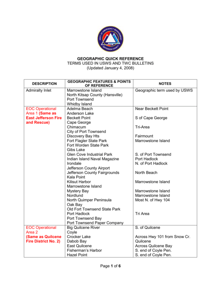
GEOGRAPHIC QUICK REFERENCE TERMS USED IN USWS AND TWC BULLETINS (Updated January 4, 2008) DESCRIPTION Admiralty Inlet EOC Operational Area 1 (Same as East Jefferson Fire and Rescue) EOC Operational Area 2 (Same as Quilcene Fire District No. 2) GEOGRAPHIC FEATURES & POINTS OF REFERENCE Marrowstone Island North Kitsap County (Hansville) Port Townsend Whidby Island Adelma Beach Anderson Lake Beckett Point Cape George Chimacum City of Port Townsend Discovery Bay Hts Fort Flagler State Park Fort Worden State Park Gibs Lake Glen Cove Industrial Park Indian Island Naval Magazine Irondale Jefferson County Airport Jefferson County Fairgrounds Kala Point Kilisut Harbor Marrowstone Island Mystery Bay Nordlund North Quimper Peninsula Oak Bay Old Fort Townsend State Park Port Hadlock Port Townsend Bay Port Townsend Paper Company Big Quilcene River Coyle Crocker Lake Dabob Bay East Quilcene Fisherman’s Harbor Hazel Point Page 1 of 6 NOTES Geographic term used by USWS Near Beckett Point S of Cape George Tri-Area Fairmount Marrowstone Island S. of Port Townsend Port Hadlock N. of Port Hadlock North Beach Marrowstone Island Marrowstone Island Marrowstone Island Most N. of Hwy 104 Tri Area S. of Quilcene Across Hwy 101 from Snow Cr. Quilcene Across Quilcene Bay S. end of Coyle Pen. S. end of Coyle Pen. EOC Operational Area 3 (Same as Port Ludlow Fire and rescue) EOC Operational Area 4 (Same as Brinnon Fire District No. 4) EOC Operational Area 5 (Same as Discovery Bay Fire District No. 5) EOC Operational Area 6 (Western Jefferson County) Lake Leland Little Quilcene River Lords Lake Dam Mount Walker – part Penny Creek Quilcene Quilcene Bay Snow Creek Thorndyke – part Beaver Valley - part Bridgehaven Hood Canal Bridge Hood Head Mats Mats Bay Oak Bay – part Olele Point Paradise Bay Port Ludlow Shine South Point Squamish Harbor Swansonville Teal Lake Thorndyke – part Black Point Brinnon Camp Parsons Canal Tracts (aka Olympic Canal Tracts) Dosewallips River Dosewallips State Park Duckabush River Jackson Cove Lazy C Mount Walker - part Pleasant Harbor Marina Seal Rock Campground South county line (Mason County) Triton Cove Diamond Point Discovery Bay Eaglemount – part East county line (Clallam County) Fairmount Gardiner Clearwater Community Hoh Reservation Kalaloch Oil City Community Queets Village Page 2 of 6 N. of Quilcene Head of Little Quilcene R. Hwy 101 S Quilcene S. of Discovery Bay S. of Hood Canal Br. N. of Hood Canal Br. Near the Bridge W. of Port Ludlow Pleasant Harbor Bee Mill Road Brinnon S. of Brinnon Dosewallips River Black Point South county line (Mason) Olympic National Park N. side Hoh River Hwy 101 @ MP 152 Inland Waters North Coast (May be reference to Pacific beaches or inland waters; see next) North Coast Northern Interior Olympic Mountains Olympic Peninsula Outer Coast Puget Sound Snoqualmie Pass South county line (Grays Harbor County) Upper Hoh Community West Jefferson County Admiralty Inlet All (salt) water West of Port Angeles Hood Canal Puget Sound South Puget Sound Cape Flattery Clearwater Hoh Reservation Hoh River Jefferson County – West Kalaloch La Push Neah Bay Queets River Queets Village Quinault Nation Waters of the Strait of Juan de Fuca along N. coast of Olympic Peninsula; MAY also be used for North coast of Pacific (same as Northern part of Outer Coast); from Flattery to Admiralty Inlet East Jefferson County Kitsap Peninsula Northern Hood Canal Northern Mason County San Juan Island Whidby Island Olympic Peninsula above 2000’ unless otherwise specified in the bulletin N. Grays Harbor County, Mason County, Clallam County and Jefferson County Adjacent to the ocean beaches of the State of Washington (Columbia River to Tattosh Island) Bainbridge Island King County Kitsap County Olympia Pierce County Seattle (Elliot Bay) Snohomish County Tacoma Interstate 80 (Issaquah – Ellensburg Page 3 of 6 Hoh Rain Forest Geographic term used by USWS Geographic term used by USWS Hoh Tribe Quillauyte Tribe Makah Tribe Geographic term used by USWS Geographic term used by USWS Geographic term used by USWS Geographic term used by USWS Geographic term used by USWS Geographic term used by USWS Could be modified by South or North Geographic term used by USWS South Coast Southern Interior Stevens Pass Strait of Juan de Fuca Eastern Entrance Strait of Juan de Fuca, Western Entrance Washington Coast Western Washington – Spokane) Grays Harbor County Long Beach Ocean Shores South Bend Westport Willapa Bay Pierce County South Mason County Thurston County US 2 (roughly Monroe/Gold Bar – Wenatchee) Admiralty Inlet Port Townsend San Juan Island Whidby Island Clallam Bay – Sekiu Clallam County - West Neah Bay Tattosh Island All of the outer coast of Washington All of Western Washington State to the Cascade Mountains Geographic term used by USWS Geographic term used by USWS Geographic term used by USWS Geographic term used by USWS Geographic term used by USWS Geographic term used by USWS Geographic term used by USWS U.S. HIGHWAY 101 MILE POSTS EAST JEFFERSON CO (References are approximate) MP 271 272 275 REFERENCE Seven Cedars Casino Jamestown Tribal Center Jefferson/Clallam County Line 276 277 281 282 285 292 294 296 298 300 305 305 306 308 314 Gardiner Discovery Mobile Home Park Discovery Bay Store Highway 20 junction Highway 104 junction Lords Lake Road Town of Quilcene Big Quilcene River Bridge Falls View Campground Mount Walker Town of Brinnon Seal Rock Campground Dosewallips River Pleasant Harbor Marina Triton Cove State Park NOTES Diamond Point Road/Chicken Coop Road; MP 274.6 To Port Townsend To Hood Canal Bridge USFS Viewpoint Road USFS Dosewallips State Park Page 4 of 6 314 317 319 328 332 334 335 Jefferson/Mason County Line Hamma Hamma Road Hamma Hamma River Lilliwaup Hoodsport Skokomish Indian Reservation SR 3 junction Mike’s Beach Eldon (gas) To Bremerton U.S. HIGHWAY 101 MILE POSTS WEST JEFFERSON CO (References are approximate) 193 193 191 185 179 178 177 176 170 164 158 152 147 145 130 129 110 La Push Road “A” Road (USFS Rd. 29) City of Forks Jefferson/Clallam County Line Upper Hoh Road Oil City Road Hoh Campground/Store Clearwater Road Nolan Creek Bridge Olympic National Park Kalaloch Lodge Queets River Clearwater Road Jefferson County/Grays Harbor County line Amanda Park South Shore Road Humptulips Realto Beach/ONP/ Mora Hoh Rain Forest North end; OCC Ruby Beach Kalaloch Ranger Station Queets Village/Trading Post South end Queets School Lake Quinault Upper part of RD in JeffCo TERMINOLOGY OFTEN USED IN U. S. WEATHER SERVICE (USWS) BULLETINS IN BULLETINS THIS TERM ADVISORY GALE WARNING HEAVY SNOW MEANS Highlights special weather conditions that are less serious than a warning. They are for events that may cause significant inconvenience, and if caution is not exercised, it could lead to situations that may threaten life and/or property. A warning of sustained surface winds, or frequent gusts, in the range of 34 knots (39 mph) to 47 knots (54 mph) inclusive, either predicted or occurring, and not directly associated with a tropical cyclone. This generally means snowfall accumulating to 4" or more in depth in 12 hours or less; or snowfall accumulating to 6" or more in depth in Page 5 of 6 24 hours or less. In forecasts, snowfall amounts are expressed as a range of values, e.g., "8 to 12 inches." However, in heavy snow situations where there is considerable uncertainty concerning the range of values, more appropriate phrases are used, such as "...up to 12 inches..." or alternatively "...8 inches or more...". Sustained wind speeds of 40 mph or greater lasting for 1 hour or HIGH WIND longer, or winds of 58 mph or greater for any duration. This product is issued by the National Weather Service when high wind HIGH WIND speeds may pose a hazard. Generally means winds greater than or ADVISORY equal to 45 mph for any duration. HIGH WIND This product is issued by the National Weather Service when high wind speeds may pose a hazard or is life threatening.. WARNING This product is issued by the National Weather Service when there is HIGH WIND WATCH the potential of high wind speeds developing that may pose a hazard or is life threatening. A warning for sustained winds, or frequent gusts, of 64 knots (74 mph) HURRICANE FORCE or greater, either predicted or occurring, and not directly associated with WINDS a tropical cyclone. A warning is issued when a hazardous weather or hydrologic event is occurring, is imminent, or has a very high probability of occurring. WARNING A warning is used for conditions posing a threat to life or property. A watch is used when the risk of a hazardous weather or hydrologic event has increased significantly, but its occurrence, location, WATCH and/or timing is still uncertain. It is intended to provide enough lead time so that those who need to set their plans in motion can do so. Page 6 of 6
