Water Erosion:
advertisement
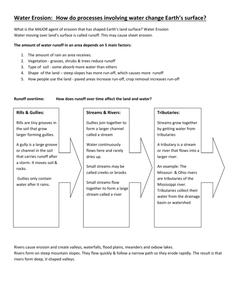
Water Erosion: How do processes involving water change Earth’s surface? What is the MAJOR agent of erosion that has shaped Earth’s land surface? Water Erosion Water moving over land’s surface is called runoff. This may cause sheet erosion. The amount of water runoff in an area depends on 5 main factors: 1. 2. 3. 4. 5. The amount of rain an area receives. Vegetation - grasses, shrubs & trees reduce runoff Type of soil - some absorb more water than others Shape of the land – steep slopes has more run-off, which causes more runoff How people use the land - paved areas increase run-off, crop removal increases run-off Runoff overtime: How does runoff over time affect the land and water? Rills & Gullies: Streams & Rivers: Tributaries: Rills are tiny grooves in the soil that grow larger forming gullies. Gullies join together to form a larger channel called a stream Streams grow together by getting water from tributaries A gully is a large groove or channel in the soil that carries runoff after a storm. It moves soil & rocks. Water continuously flows here and rarely dries up. A tributary is a stream or river that flows into a larger river. Small streams may be called creeks or brooks An example: The Missouri & Ohio rivers are tributaries of the Mississippi river. Tributaries collect their water from the drainage basin or watershed Gullies only contain water after it rains. Small streams flow together to form a large stream called a river Rivers cause erosion and create valleys, waterfalls, flood plains, meanders and oxbow lakes. Rivers form on steep mountain slopes. They flow quickly & follow a narrow path so they erode rapidly. The result is that rivers form deep, V-shaped valleys. Features of rivers: What are the features that erosion forms along a river? Waterfalls: Flood Plains: Meanders: Oxbow Lakes: Occur where a river meets an area of hard & slowly eroding rock. Lower down on the river’s course, it flows over a wide river valley, an area of land called a flood plain Are loop-like bends in the course of a river. Sometimes meandering rivers form an oxbow lake a meander that has been cut-off from the river. Then flows over softer rock downstream. The softer rock erodes away faster & a waterfall develops. During flooding the water in the river over flows its banks into this wide river valley area. They occur as the outer bank of a river is eroded & deposits are dropped on the inner bank of the bend in a river. Example: southern stretch of the Mississippi River meanders on a wide, gently sloping flood plain area They may form when a river floods as high water finds a straighter path downstream . As flood waters fall, sediments dam up the ends of the meander and a lake forms Deposits by rivers are made as the water slows down and the fine particles settle in the river bed. Larger stones quit rolling and sliding. Deposition creates landforms such as alluvial fans and deltas and can also add soil to a river’s flood plain. Deposits by Rivers: What features result from deposition along a river? An Alluvial Fan is a wide, sloping deposit of sediment formed where a stream leaves a steep, narrow mountain valley range. This deposit is shaped like a fan. Deltas form when sediments are deposited where a river flows into an ocean or a lake. A landform is built up as the sediments drop. Soil may also be added to Flood Plains during floods as sediments are deposited. This new soil added to the area makes the river valley fertile. Forests and crops may be grown here. Groundwater Erosion: What results from water seeping into the ground & mixing with CO 2? Not all rain water evaporates or becomes runoff. Some water soaks into the ground, filling openings in the soil and trickling into cracks & spaces in layers of rock. Groundwater erosion is caused by the process of chemical weathering: Carbonic Acid forms as carbon dioxide & water combine. This weak acid can break down limestone that will gradually hollow out pockets in the rock. Over time, the pockets develop into large holes called caves or caverns. Cave Formations: What are the features found in a cave? How do they form? Water containing carbonic acid & calcium drip from a cave’s roof forming stalactites (like icicles hanging from the top) and stalagmites (drips the build up from the bottom of the cave floor) Karst Topography: What happens when land rich in limestone is weathered by groundwater? In rainy regions where limestone near the surface is weathered and groundwater erosion can cause the roof of the cave to collapse leaving a sinkhole – this type of landscape is called karst topography. In the U.S. regions of Florida & Texas have these areas. Erosion by Glaciers: How do glaciers cause erosion and deposition? Glaciers: A glacier is any large mass of ice that moves slowly over land and form in areas where more snow falls than melts. (Watch Brain Pop – Free Movie - Glaciers) What are the 2 types of glaciers? How are they alike? How are they different? Continental Glaciers Valley Glaciers Covers Land or Continents Spreads out over millions of square kilometers, cover about 10% of Earth’s land, cover most of Greenland & Antarctica, in the past these Have covered larger parts of Earth – times are called Ice Ages Large masses of ice, move slowly on land, shape the land Forms high in mountains when snow & ice builds up in a mountain valley Stay narrow& long held in by the sides of the mountain, smaller than Cont. Glaciers, form U-shaped valleys How do Glaciers shape the land? They begin to move due to the force of gravity and erode the land by plucking & abrasion Plucking happens as glaciers move across the land. They pick up rocks, the weight of the glacier breaks them apart & they freeze to the bottom of the glacier and the glacier carries the rock fragments along with it. As the glacier drags the rocks along, the land is gouged & scratched by the rocks. This process is called Abrasion. Glaciers make deposits along the land as they melt and drop the sediments on their bottoms as till – particles of different sizes – clay, silt, sand, gravel & boulders can be found in till. Till deposited along the edges of a glacier forms a ridge called a moraine. Long Island in New York is a terminal moraine (it was the very last point reached by the glacier that deposited it). As glaciers melt they leave their marks called kettles – small depressions left in areas when chunks of ice are left in glacial till. They fill in with water and form ponds or lakes - called kettle lakes (common in Minnesota) Erosion by Waves: How do waves erode a coast? What features result from deposition by waves? Remember: Waves are caused by the energy from the wind being transferred to the water. Erosion by Waves: Waves shape the coast through erosion by breaking down rock and transporting sand and other sediment. They erode hard, rocky areas of the coast that jut out just like jagged mountains are eroded over time. Deposits by Waves: Waves deposit sediment as they slow down. Beaches, spits & barrier beaches are formed. Beach: Spit: An area of wave-washed sediment along a coast, sands may be made of coral or sea shells A beach that projects or sticks out like a finger Sediments on the beach are moved down the beach as waves that move with the current move down the shore – this is called the longshore drift Spits form as a result of longshore drift depositing sediments along a coast Sandbars or Barrier Beaches: Long ridges of sand that run parallel to the beach Storms deposit sand above sea level People build houses on the large ones DANGER: storms that build them can also destroy them Erosion by Wind: How does wind cause erosion? What features result from deposition by wind? Wind causes erosion by deflation & abrasion Wind is the weakest agent of erosion, but can be powerful in shaping the land in areas where there are few plants to hold the soil in place. Example: the deserts Deflation: Abrasion: Wind blows across the land and removes surface materials, easily picks up the smallest particles of sediment, heavier particles only bounce around for a short time, does not usually have a huge effect on the land Can polish rock, causes little erosion, mostly a form of weathering Deposition by wind forms sand dunes (plant roots hold in place) and loess deposits (makes fertile soils, valuable farmland) Sand Dunes: Loess Deposits: Wind shifts sand from one side of the dune to the other slowly Tiny particles of sediments, deposited in layers far from its source
