Swallow Hole/Resurgence/Shake Hole
advertisement
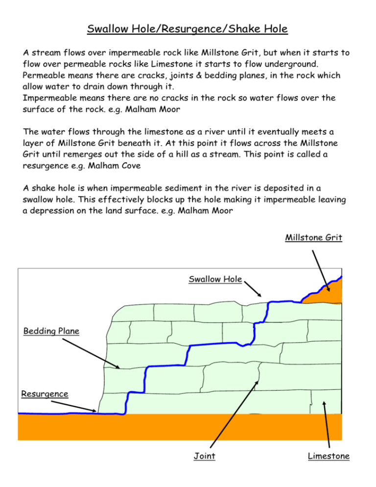
Swallow Hole/Resurgence/Shake Hole A stream flows over impermeable rock like Millstone Grit, but when it starts to flow over permeable rocks like Limestone it starts to flow underground. Permeable means there are cracks, joints & bedding planes, in the rock which allow water to drain down through it. Impermeable means there are no cracks in the rock so water flows over the surface of the rock. e.g. Malham Moor The water flows through the limestone as a river until it eventually meets a layer of Millstone Grit beneath it. At this point it flows across the Millstone Grit until remerges out the side of a hill as a stream. This point is called a resurgence e.g. Malham Cove A shake hole is when impermeable sediment in the river is deposited in a swallow hole. This effectively blocks up the hole making it impermeable leaving a depression on the land surface. e.g. Malham Moor Millstone Grit Swallow Hole Bedding Plane Resurgence Joint Limestone Cave Systems & Dripstone Features Caves, as natural cracks or tunnels (joints & bedding planes) in limestone, are widened to the point of collapse. This process is the result of water action, which erodes the tunnels at their base. This causes the sides to undercut, overhang and then collapse as there is no support for the walls creating a cave. Water with dissolved limestone (Calcium Hydrogen Carbonate) in it travels through joints and bedding planes in limestone. As it does so, it comes into contact with CO2 in the air, whereby a chemical reaction takes place depositing limestone. There are many impurities in the limestone deposits and so it is called calcite rather than limestone. Any feature made from these deposits is called a drip stone deposit. As water drops slowly evaporate from a cave roof they leave behind deposits of calcite, which hang down from the ceiling like icicles of rock. These tend to be quite angular in appearance, called stalactites. When drops of water hit the floor of the cave they leave behind calcite. This time the rock builds upwards, though is wider and rounder than a stalactite due to the water droplet spreading when it hits the cave floor, called stalagmites. A pillar simply forms from the above two processes joining together, so have more angular tops and rounded wider bottoms. It is the rarest of the three dripstone deposits. All these dripstone features grow slowly around 7mm a year. Stalactite Stalagmite Pillar Gorges There are two different theories on how limestone gorges develop; though in reality it is probably a bit of both. The first is due to solution and water erosion affecting underground tunnels (joints & bedding planes) in the limestone. At the base of the tunnel walls, these processes undercut the wall leading to overhanging walls, which eventually collapse due to the lack of support. If this happens repeatedly a vast cavern develops, which if close to the surface, means that the roof will eventually collapse leaving a gorge. A second idea is that a very fast flowing river eroded the gorge. This is thought to have been taken place around 10,000 years ago during the last ice age. The ground would have been permanently frozen and so the natural joints of the limestone would have been plugged with ice. As the glaciers melted vast amounts of fast flowing water would have been able to cut the gorge. The ice plugs would have remained for a period of time as they would be underground and so protected from the sun. Erosion Of Tunnels Collapsed Cavern Or Gorge Dry Valleys Bedding Planes Joints Ice Plugs A dry valley can form in one of two ways, both requiring a river to flow over limestone, which because of its permeability means it can’t support rivers. Permeable mean it has many joints and bedding planes through which water drains, meaning no rivers on the surface. The first theory suggests that during the last ice age the ground became permanently frozen, this effectively plugged the joints and bedding planes of the limestone making it impermeable. When meltwater flowed over the limestone it was able to erode a v-shaped valley. As the ice plugs were underground they took longer than surrounding ice to melt and so were still present despite surface ice melting. When the ice plugs eventually melt due to warmer weather, they make the limestone permeable again and so the water that was once in the valley drains away; as there is a lower supply of water once the ice has melted it is easier for water to drain through limestone than over it. The alternative theory is that during a period of heavier rainfall the limestone became saturated so that water flowing over it couldn’t drain away. This meant that rivers flowed over its surface eroding a v-shaped valley. When the climate became drier the limestone became less saturated and so allowed surface water to drain through it again leaving a dry v-shaped valley. Limestone Scars Cliff 10 – 20m high Angular Scree Larger Stones Low Down These are long cliffs found in Limestone areas e.g. Twistleton Scar in the Yorkshire Dales. They initially form as glaciers erode a U shaped valley, bulldozing rock spurs away as it moves and forming these cliffs. They are then modified after glaciation by freeze-thaw weathering. This is when water gets into a crack in rock and then freezes. The resulting ice exerts an internal pressure on the rock as it has a volume 7% greater than that of water. The ice then melts due to warmer temperatures, but if the process repeats it will eventually force the rock apart into small stones. For this to be an effective process the temperature needs to fluctuate around 0°C in order to give constant freeze-thaw conditions. The rocks fall of the cliff at a rapid rate gathering at its base forming a scree slope. The larger rocks are found at the bottom of the scree slope as they bounce down further than the smaller rocks due to momentum. The actual fall or flow of rock downslope doesn’t require water, although initially it is required for freeze-thaw to take place. OS Map Work Limestone Pavement Swallow Hole Resurgence Dry Valley Scar (A) (D) (F) (E) (B,C) These are the only landforms that you will be asked to find on an OS map. Limestone Pavement & Scar 200 A A Outcrop Symbol B B Cliff Symbol C Scree & Close Contours 150 Swallow Hole Resurgence Dry Valley D River Stops 200 150 C D E E Contours Point Uphill F River Starts F LimestoneF Pavement - flat area of exposed limestone rock, shown by spaced contours and outcrop symbols. Swallow Hole - where a river starts to flow underground, shown by a blue winding river which suddenly stops. It will cross contours which point uphill in an inverted v shape. Resurgence - where an underground river emerges, shown by the start of a blue winding line flowing over inverted v shaped contours. N.B. There must be a river which has disappeared above the resurgent river! Dry Valley - a river valley with no river in it, shown by a series of inverted v shaped contours indicating a river valley but with no blue winding line, or river, in it. Scar - a long cliff, shown by a black line with black “eyelashes” pointing downhill, contours will be packed together indicating steep land and black dots below the cliff representing scree.

