Chapter 12 Review
advertisement
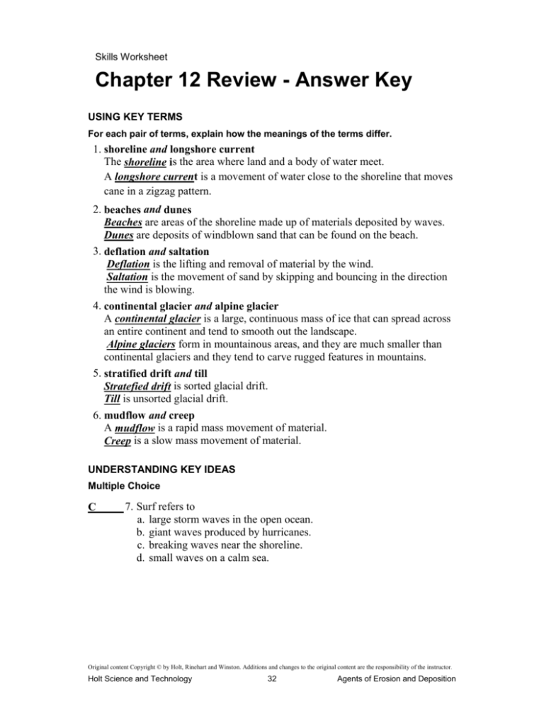
Skills Worksheet Chapter 12 Review - Answer Key USING KEY TERMS For each pair of terms, explain how the meanings of the terms differ. 1. shoreline and longshore current The shoreline is the area where land and a body of water meet. A longshore current is a movement of water close to the shoreline that moves cane in a zigzag pattern. 2. beaches and dunes Beaches are areas of the shoreline made up of materials deposited by waves. Dunes are deposits of windblown sand that can be found on the beach. 3. deflation and saltation Deflation is the lifting and removal of material by the wind. Saltation is the movement of sand by skipping and bouncing in the direction the wind is blowing. 4. continental glacier and alpine glacier A continental glacier is a large, continuous mass of ice that can spread across an entire continent and tend to smooth out the landscape. Alpine glaciers form in mountainous areas, and they are much smaller than continental glaciers and they tend to carve rugged features in mountains. 5. stratified drift and till Stratefied drift is sorted glacial drift. Till is unsorted glacial drift. 6. mudflow and creep A mudflow is a rapid mass movement of material. Creep is a slow mass movement of material. UNDERSTANDING KEY IDEAS Multiple Choice C 7. Surf refers to a. large storm waves in the open ocean. b. giant waves produced by hurricanes. c. breaking waves near the shoreline. d. small waves on a calm sea. Original content Copyright © by Holt, Rinehart and Winston. Additions and changes to the original content are the responsibility of the instructor. Holt Science and Technology 32 Agents of Erosion and Deposition Chapter Review continued B____ 8. When waves cut completely through a headland, a _____ is formed. a. sea cave c. wave-cut terrace b. sea cliff d. sand bar A____ 9. A narrow strip of sand that is formed by wave deposition and is connected to the shore is called a a. barrier spit. c. wave-cut terrace. b. sandbar. d. headland. A____ 10. A wind-eroded depression is called a a. deflation hollow. c. dune. b. desert pavement. d. dust bowl. A____ 11. What term describes all types of glacial deposits? a. glacial drift c. till b. dune d. outwash B____ 12. Which of the following is NOT a landform created by an alpine glacier? a. cirque c. horn b. deflation hollow d. arête A____ 13. What is the term for a mass movement that is of volcanic origin? a. lahar c. creep b. slump d. rock fall C____ 14. Which of the following is a slow mass movement? a. mudflow c. creep b. landslide d. rock fall Short Answer 15. Why do waves break when they near the shore? When waves reach shallow water, the lower part of the wave is crowded by the ocean floor. The waves become taller and eventually grow so tall that it cannot support itself. When the wave reaches this point, it curls and breaks. 16. Why are some areas more affected by wind erosion than other areas are? Areas with little vegetation, deserts, and coastlines are more affected by wind erosion than other areas because there are few plant roots to anchor the and soil in place. 17. What kind of mass movement happens continuously, day after day? Creep is the extremely slow mass movement of material downslope that happens continuously, day after day. Original content Copyright © by Holt, Rinehart and Winston. Additions and changes to the original content are the responsibility of the instructor. Holt Science and Technology 33 Agents of Erosion and Deposition Chapter Review continued 18. In what direction do sand dunes move? Sand dunes move in the direction of the strong winds. 19. Describe the different types of glacial moraines. Lateral moraine form along each side of a glacier. Medial moraines form when valley glaciers meet. Ground moraines form from unsorted materiall left beneath a glacier. Terminal moraines form when sediment is dropped at the front of a glacier. CRITICAL THINKING 20. Concept Mapping Use the following terms to create a concept map: deflation, strong winds, saltation, dune, and desert pavement. Wind Causes saltation deflation which can form a which can form a desert pavement dune Original content Copyright © by Holt, Rinehart and Winston. Additions and changes to the original content are the responsibility of the instructor. Holt Science and Technology 34 Agents of Erosion and Deposition Chapter Review continued 21. Making Inferences How do humans increase the likelihood that wind erosion will occur? Humans increase the likelihood that wind erosion will occur when they remove native plants from the area to make room for agricultural land. Plants anchor the soil place. By removing the plants, the land becomes more vulnerable to wind erosion. 22. Identifying Relationship If the large ice sheet covering Antarctica were to melt completely, what type of landscape would you expect Antarctica to have? Since the large ice sheets covering Antarctica are a continental glacier, one would expect the land under to be smooth and flat if the glacier were to completely melt. 23. Applying Concepts You are a geologist who is studying rock to determine the direction of flow of an ancient glacier What clues might help you determine the glacier's direction of flow? Clues that a geologist would use to determine the flow of an ancient glacier would be evidence of outwash plains, which would indicate deposits in front of the glacier. 24. Applying Concepts You are interested in purchasing a home that overlooks the ocean. The home that you want to buy sits atop a steep sea cliff. Given what you have learned about shoreline erosion, what factors would you take into consideration when deciding whether to buy the home? Factors that need to be considered when purchasing a home that overlooks the ocean would be the frequency of storms in the area and the rate the surrounding shoreline is eroding. _______________________________________________________________ _______________________________________________________________ Original content Copyright © by Holt, Rinehart and Winston. Additions and changes to the original content are the responsibility of the instructor. Holt Science and Technology 35 Agents of Erosion and Deposition Chapter Review continued INTERPRETING GRAPHICS The graph below illustrates coastal erosion and deposition at an imaginary beach over a period of 8 years. Use the graph below to answer the questions that follow. 25. What is happening to the beach over time? In the earlier years, the more soil is being eroded than deposited and the beach is getting smaller. After 2007, more soil is being deposited than eroded and the beach is getting larger. 26. In what year does the amount of erosion equal the amount of deposition? In 2007, the amount of erosion equals (25 m) the amount of deposition (25 m). 27. Based on the erosion and deposition data for 2005, what might happen to the beach in the years that follow 2005? In 2005, more sand is being eroded than deposited. The coastline is losing land. This pattern would lead you to believe that the coastline would continue shrinking. But after 2007, the coastline stops loosing land and begins growing. Original content Copyright © by Holt, Rinehart and Winston. Additions and changes to the original content are the responsibility of the instructor. Holt Science and Technology 36 Agents of Erosion and Deposition
