Mediterranean Storms
advertisement
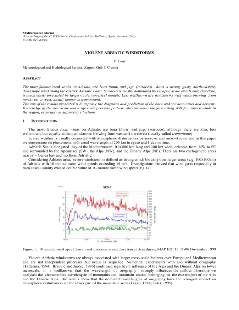
Mediterranean Storms (Proceedings of the 4th EGS Plinius Conference held at Mallorca, Spain, October 2002) 2002 by Editrice VIOLENT ADRIATIC WINDSTORMS V. Tutiš Meteorological and Hydrological Service, Zagreb, Grič 3, Croatia ABSTRACT The most famous local winds on Adriatic are bora (bura) and jugo (scirocco). Bora is strong, gusty, north-easterly downslope wind along the eastern Adriatic coast. Scirocco is mostly dominated by synoptic-scale events and, therefore, is much easily forecasted by larger-scale numerical models. Less wellknown are windstorms with winds blowing from northwest or west, locally known as tramontana. The aim of the results presented is to improve the diagnosis and prediction of the bora and scirocco onset and severity. Knowledge of the mesoscale and large scale pressure patterns also increases the forecasting skill for surface winds in the region, especially in hazardous situations. 1 INTRODUCTION The most famous local winds on Adriatic are bora (bura) and jugo (scirocco), although there are also, less wellknown, but equally violent windstorms blowing from west and northwest (locally called tramontana) Severe weather is usually connected with atmospheric disturbances on meso- and meso- scale and in this paper we concentrate on phenomena with usual wavelength of 200 km in space and 1 day in time. Adriatic Sea is elongated bay of the Mediterranean. It is 800 km long and 200 km wide, oriented from NW to SE and surrounded by the Apennines (SW), the Alps (NW), and the Dinaric Alps (NE). There are two cyclogenetic areas nearby – Genoa bay and northern Adriatic. Considering Adriatic area, severe windstorm is defined as strong winds blowing over larger areas (e.g. 100x100km) of Adriatic with 10 minute mean wind speeds exceeding 10 m/s. Investigations showed that wind gusts (especially in bora cases) usually exceed double value of 10-minute mean wind speed (fig.1) Figure 1. 10 minute wind speed (mean and maximum) and direction at Senj during MAP IOP 15 07-08 November 1999 Violent Adriatic windstorms are always associated with larger meso-scale features over Europe and Mediterranean and are not independent processes but occur in sequence. Numerical experiments with and without orography (Tafferner, 1994; Brzović and Jurčec, 1996) confirmed significant influence of the Alps and the Dinaric Alps on lower mesoscale. It is wellknown that the wavelength of orography strongly influences the airflow. Therefore we analysed the characteristic wavelengths of mountains and mountain chains belonging to the eastern part of the Alps and the Dinaric Alps. The results show that the dominant wavelengths of orography have the strongest impact on atmospheric disturbances on the lower part of the meso-beta scale (Green, 1984; Tutiš, 1995). The windstorm intensity depends usually on the first event in the chain – e.g., for bora cases, it is a cold front, following by its deformation and then the cold air outbreak over the Alps. The second event is a lee cyclogenesis which occurs either in the Gulf of Genoa or in the northern Adriatic, depending on the upstream atmospheric structure. In case of Adriatic cyclone, scirocco (jugo) blows in front and bora in the rear of this cyclone 2 BORA WINDSTORMS Bora is strong, gusty, north-easterly downslope wind along the eastern Adriatic coast. Although recent bora investigation showed essential differences between bora behaviour in the northern and southern Adriatic, investigation of all severe bora cases reveal the multiscale nature of bora wind: the bora onset, its longevity and severity are closely related to larger mesoscale features, in particular those resulting from the interaction processes of synoptic scale flow with the Alpine massif and bora speed and direction are greatly influenced by local topographic shape. So, when discussing severe bora wind, we have to account that such windstorms are mostly subsynoptic features, strongly influenced by local processes and orography and are, therefore, very difficult to study by regular synoptic network. There are generally three classical synoptic weather patterns leading to severe bora flow: anticyclonic bora type – when there is a strong anticyclone north or northeast of the Alps, producing strong pressure gradients over the Dinaric Alps (thus pushing the air from inland to Adriatic area) frontal bora type – rather brief episodes of bora, following the cold front movement (duration and intensity of bora is directly dependent on amount of cold air following the cold front) cyclonic bora type – when there is a Mediterranean cyclone close to the Dinaric Alps, producing strong pressure gradients over the Dinaric Alps (thus drawing the air out from inland to Adriatic area) On mesoscale, the severe bora wind is related to the cold airflow in the lower troposphere, upstream blocking, splitting and flowing over the orographic obstacle. There is also general distinction between northern Adriatic bora and middle Adriatic (Dalmatian) bora. Investigation showed that 2D hydraulic theory gives rather good description of northern Adriatic bora (fig.2), defining critical level either as the level of strong temperature inversion or as the level of flow reversal. The upstream conditions suitable for bora onset can be divided into two main groups: 1) unidirectional northern flow throughout the troposphere (the tropopause being capping critical layer) 2) shallow low level bora flow below a critical level (usually at some height in the lower troposphere). Figure 2. Bora flow of hydraulic type. A-C accelerated flow; B high turbulence zone. Middle Adriatic bora is in most cases result of different physical processes, i.e. leeward mountain downslope flow and wave breaking aloft (fig.3 a,b). Simultaneous isentropic analyses of atmospheric motion give very realistic 3D picture of the airflow. It has been shown that in the lower troposphere during the bora periods there is a pronounced downward NW-SE motion over the Europe. Concerning hydraulic character of the atmospheric motion, such inclination of air trajectories indicate strong acceleration of atmospeheric motion upstream of the Dinaric Alps. Consequently, many case studies of the bora events, particularly during the Alpine experiment (ALPEX, March-April 1982) indicate the phenomenon of low-level jet stream (LLJ) in connection to the bora flow (also observed in many other mountain regions around the world). A jet is a region of relatively strong wind that is concentrated into a narrow, quasihorizontal or horizontal stream. The criteria that satisfy the conditions “relatively strong” and “narrow” are subjective for low-level jet streams (below 5 km height). It seems that the LLJ associated with the Adriatic bora flow, undergoes a marked diurnal variation in strength - it is usually stronger at night and weaker during the day (the same variation follows the surface bora wind). Figure 3. Conceptual model of middle Adriatic bora – application of mountain wave theory It is also shown that the pressure drag is highly correlated (cross-correlation coefficients 0.9) with the crossmountain pressure differences. The orographically induced high-low pressure couplets cause locally strong pressure gradients over the mountainous area. In such situations a surface pressure drag acts as a mechanism of atmospheric momentum sink on synoptic (meso- and ) and global scale, and atmospheric momentum source on lower meso- and meso- scale. 3 SCIROCCO WINDSTORMS Scirocco (jugo) is a southerly or southeasterly warm and humid wind in the Adriatic sea customarily cosidered as scirocco wind which originates in the Sahara. Case studies show that severe scirocco events are associated with a deep lee cyclone south of the Alps that may draw dry and dusty air from North Africa to the Mediterranean. A noteworthy feature is a mesoscale low in the northern Adriatic, which is not detected on synoptic charts. Employing the scale separation technique, it is shown that the development of subsynoptic cyclonic vortex may provide conditions favourable for Adriatic Scirocco windstorm development. Figure 3. Conceptual model of Adriatic scirocco However, scirocco is mostly dominated by synoptic-scale events and, therefore, is much easily forecasted by largerscale numerical models. The most severe cases are connected to the southern upper-level airstream over the Adriatic (ahead of a deep upper-level trough) during the presence of a Mediterranean cyclone. Such a situation is favourable for restoring a gradient-like stream, especially over the sea where surface friction is negligible. Observations indicate the development of the low level jet along the Adriatic, usually around 1,5 km height (Fig.4) When severe scirocco situation is lasting for a several days one of the most wellknown consequence, except the marine traffic disruption, is an unusual high sea level causing sometimes the flooding of Venice. 4 TRAMONTANA WINDSTORMS Violent westerly or northwesterly winds over Adriatic are up to now more wellknown among nautical and weather forecasting community than among scientific meteorological community. Such windstorms are mostly produced by cyclone`s internal circulation and development of low-level jet in the rear of cold front, especially in cases when a cyclone is moving from Italy over the Adriatic and the Dinaric Alps into the inland of Croatia. (fig.5). Tramontana windstorms are especially dangerous for marine traffic because of development of high, ocean–like waves at the sea surface. Figure 3. Conceptual model of Adriatic tramontana 5 CONCLUSION The aim of the results presented is to improve the diagnosis and prediction of the windstorms events onset and severity. Knowledge of the mesoscale and large scale pressure patterns also increases the forecasting skill for surface winds in the region, especially in hazardous situations. REFERENCES Green, J.S.A.: Describing the Alps. Rivista di Meteorologica Aeronautica. V.XLII, 23-30, 1984 Ivančan-Picek B. and V. Tutiš: Influence of orography on subsynoptic storm development. MAP Newsletter, No 5, 7273, 1996 Ivančan-Picek B. and V. Tutiš,: A case study of severe Adriatic bora on 28 December 1992, Tellus 48 a, 357-367, 1996 Ivančan-Picek B. and V. Tutiš,: Mesoscale bora flow and mountain pressure drag. Meteor. Zeitschrift, Vol4, No3, 110, 1995 Jurčec V. , B. Ivančan-Picek ,V. Tutiš, V. Vukičević: Severe Adriatic jugo wind. Meteor. Zeitschrift, N.F.5, 76-75, 1996 Tafferner, A : Life cycle of a mountain generated Adriatic cyclone . The Life cycles of extratropical cyclones, Vol II, Bergen, 335-340, 1994 Tutiš V. and B. Ivančan-Picek: Pressure drag on the Dinaric Alps During the ALPEX SOP. Meteor. Atmos. Phy. , 47, 73-81, 1991 Tutiš, V.: Development of severe weather over non-homogenous terrain, Ph.D. dissertation, The University of Zagreb, Zagreb, 1995
