File - Thomas Tallis School
advertisement
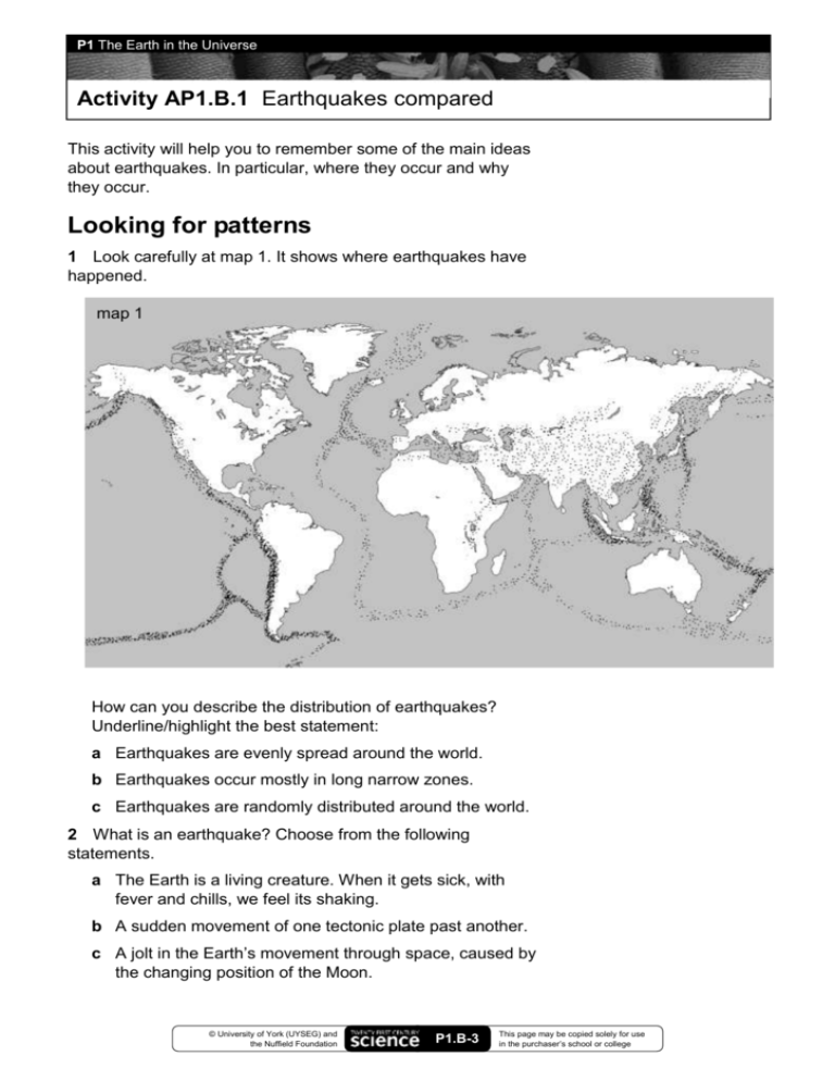
P1 The Earth in the Universe Activity AP1.B.1 Earthquakes compared This activity will help you to remember some of the main ideas about earthquakes. In particular, where they occur and why they occur. Looking for patterns 1 Look carefully at map 1. It shows where earthquakes have happened. map 1 How can you describe the distribution of earthquakes? Underline/highlight the best statement: a Earthquakes are evenly spread around the world. b Earthquakes occur mostly in long narrow zones. c Earthquakes are randomly distributed around the world. 2 What is an earthquake? Choose from the following statements. a The Earth is a living creature. When it gets sick, with fever and chills, we feel its shaking. b A sudden movement of one tectonic plate past another. c A jolt in the Earth’s movement through space, caused by the changing position of the Moon. © University of York (UYSEG) and the Nuffield Foundation P1.B-3 This page may be copied solely for use in the purchaser’s school or college P1 The Earth in the Universe Activity AP1.B.1 Earthquakes compared Look at map 2. It shows the boundaries between the tectonic plates and the names of some of the plates. map 2 3 Using Section H of your Textbook to help you, write down three facts about tectonic plates: 4 Write a sentence, explaining to a friend how the pattern of the distribution of earthquakes compares to the shapes of the plates. © University of York (UYSEG) and the Nuffield Foundation P1.B-4 This page may be copied solely for use in the purchaser’s school or college P1 The Earth in the Universe Activity AP1.B.1 Earthquakes compared Mountain ranges 5 The Himalayas, the Rockies, and the Andes are the three largest mountain ranges on land. Try to find out where they are. Shade in roughly the area which they cover on map 2, and add their names. There is a pattern about where these mountains are. They all roughly follow boundaries between two tectonic plates. What do plates do? One really important thing they do is move. For example, the Pacific Plate and the Eurasian Plate are moving towards each other. Arrows have been used to show this on map 2. 6 Draw other arrows on the map to show each of the following movements: The Indo-Australian Plate and the Eurasian Plate are moving towards each other. The South American Plate and the African Plate are moving away from each other. The North American Plate and the Eurasian Plate are moving away from each other. The North American Plate and the Pacific Plate are sliding past each other. What makes the plates move? The key to finding out how they move is to look more closely at the boundary between two plates that are moving away from each other. For example, how the Eurasian Plate and the North American Plate move apart. 7 Use a single colour to highlight the boundary on map 2 between each of these pairs of plates: The Eurasian Plate and the North American Plate The African Plate and the North American Plate The African Plate and South American Plate The line you have drawn goes right down the middle of the North and South Atlantic Oceans. It is the path of the MidAtlantic Ridge. This range of mountains under the ocean is much longer than any of the three continental mountain ranges you have marked on map 2. © University of York (UYSEG) and the Nuffield Foundation P1.B-5 This page may be copied solely for use in the purchaser’s school or college P1 The Earth in the Universe Activity AP1.B.1 Earthquakes compared 8 The ocean floor is spreading out very slowly from the ridge. New ocean floor is being made all the time as molten rock rises to fill the gap on the ridge. Based on the picture in Section H of your Textbook, try to draw a picture to show this happening. 9 Here is information about three earthquakes. Location of earthquake Date and local time Magnitude Deaths on Richter scale Damage Dudley, UK 23 September 2002 4.8 None Chimneys of houses and part of a church spire fell down; windows smashed; power cut; car alarms set off. San Francisco, California 17 October 1979 6.9 67 ‘Double decker’ motorways collapsed; houses built on infilled lakes were badly damaged; electric cables, water and sewage pipes broken; fires. Sumatra, Indonesia 26 December 2004 9.0 300 000 Towns and villages in many countries completely destroyed by a tsunami caused by the earthquake. A million people left homeless. Fishery industries and tourism very badly affected. Drinking water supplies contaminated for many years. Locations of these three earthquakes are already marked on map 2, as X, Y, and Z. Write the correct place names next to each symbol. 10 Explain why the earthquakes in California and Indonesia were much more powerful than the Dudley earthquake. © University of York (UYSEG) and the Nuffield Foundation P1.B-6 This page may be copied solely for use in the purchaser’s school or college


