GEOLOGY 1313
advertisement
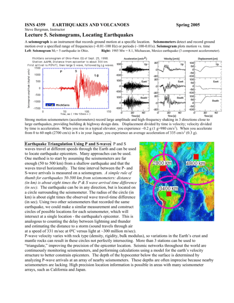
ISNS 4359 EARTHQUAKES AND VOLCANOES Spring 2005 Steve Bergman, Instructor Lecture 5. Seismograms, Locating Earthquakes A seismograph is an instrument that records ground motion at a specific location. Seismometers detect and record ground motion over a specified range of frequencies (~0.01-100 Hz) or periods (~100-0.01s). Seismogram plots motion vs. time Left: Seismogram ML= 5 earthquake in Ohio. Right: 1985 Mw = 8.1, Michaocan, Mexico earthquake (3 component accelerometer). Strong motion seismometers (accelerometers) record large amplitude and high-frequency shaking in 3 directions close to large earthquakes, providing building & highway design data. Displacement divided by time is velocity; velocity divided by time is acceleration. When you rise in a typical elevator, you experience ~0.2 g (1 g=980 cm/s 2). When you accelerate from 0 to 60 mph (2700 cm/s) in 8 s in your Jaguar, you experience an average acceleration of 335 cm/s 2 (0.3 g). Earthquake Triangulation Using P and S-waves P and S waves travel at different speeds through the Earth and can be used to locate earthquake epicenters. Many approaches can be used. One method is to start by assuming the seismometers are far enough (50 to 500 km) from a shallow earthquake and that the waves travel horizontally. The time interval between the P- and S-wave arrivals is measured on a seismogram. A simple rule of thumb for earthquakes 50-500 km from seismometers: distance (in km) is about eight times the P & S wave arrival time difference (in sec). The earthquake can be in any direction, but is located on a circle surrounding the seismometer. The radius of the circle (in km) is about eight times the observed wave travel-time difference (in sec). Using two other seismometers that recorded the same earthquake, we could make a similar measurement and construct circles of possible locations for each seismometer, which will intersect at a single location - the earthquake's epicenter. This is analogous to counting the delay between lightning and thunder and estimating the distance to a storm (sound travels through air at a speed of 331 m/sec at 0ºC versus light at ~300 million m/sec). P-wave velocity varies with rock type (density, rigidity, bulk modulus), so variations in the Earth’s crust and mantle rocks can result in these circles not perfectly intersecting. More than 3 stations can be used to “triangulate,” improving the precision of the epicenter location. Seismic networks throughout the world are continuously monitoring seismometers, and performing calculations using a model for the earth’s velocity structure to better constrain epicenters. The depth of the hypocenter below the surface is determined by analyzing P-wave arrivals at an array of nearby seismometers. These depths are often imprecise because nearby seismometers are lacking. High precision location information is possible in areas with many seismometer arrays, such as California and Japan.


