100628-09YN042-2009 Report
advertisement

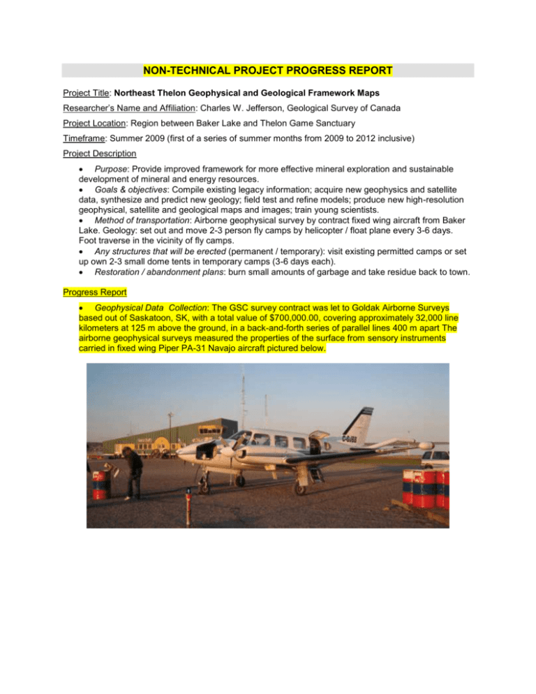
NON-TECHNICAL PROJECT PROGRESS REPORT Project Title: Northeast Thelon Geophysical and Geological Framework Maps Researcher’s Name and Affiliation: Charles W. Jefferson, Geological Survey of Canada Project Location: Region between Baker Lake and Thelon Game Sanctuary Timeframe: Summer 2009 (first of a series of summer months from 2009 to 2012 inclusive) Project Description Purpose: Provide improved framework for more effective mineral exploration and sustainable development of mineral and energy resources. Goals & objectives: Compile existing legacy information; acquire new geophysics and satellite data, synthesize and predict new geology; field test and refine models; produce new high-resolution geophysical, satellite and geological maps and images; train young scientists. Method of transportation: Airborne geophysical survey by contract fixed wing aircraft from Baker Lake. Geology: set out and move 2-3 person fly camps by helicopter / float plane every 3-6 days. Foot traverse in the vicinity of fly camps. Any structures that will be erected (permanent / temporary): visit existing permitted camps or set up own 2-3 small dome tents in temporary camps (3-6 days each). Restoration / abandonment plans: burn small amounts of garbage and take residue back to town. Progress Report Geophysical Data Collection: The GSC survey contract was let to Goldak Airborne Surveys based out of Saskatoon, SK, with a total value of $700,000.00, covering approximately 32,000 line kilometers at 125 m above the ground, in a back-and-forth series of parallel lines 400 m apart The airborne geophysical surveys measured the properties of the surface from sensory instruments carried in fixed wing Piper PA-31 Navajo aircraft pictured below. Surveying was from about August 10 to about September 10, 2009. The planes landed and took off from Baker Lake airport with no incidents, and no caribou were disturbed. The entire planned survey was completed. The data are now being processed to produce final maps. The results will be published as maps and digital data by March 31, 2011. In addition to the new data, much of the intervening areas had already been flown by the industry members of the consortium. They contributed their existing data that have been stitched together to make a continuous mosaic covering most of the study area. The research team is now engaged in analyzing, modeling and interpreting the geophysical data to help make better geological maps. Geological Data Collection: From July 3 to 17, 2009 a team of 9 senior geologists and students from the Geological Survey of Canada, Carleton University, Concordia University, University of Regina, McMaster University and the University of New Brunswick gathered in Baker Lake to participate in field orientation studies. Transportation was provided by Custom Helicopters and Guardian Helicopters. Experts of the team who had worked in the area guided the other team members to learn from well exposed rocks north and west of Baker Lake, in the Whitehills, Meadowbank River and Amer Lake areas. The team moved west toward Aberdeen Lake to examine less well exposed and understood rocks. This introduced the professors and students to the main geological features and challenges in the region. No tent camps were set up in 2009, however knowledge from the field trip will help decide locations of camps to be set up in 2010 through 2012. Those camps will be small - 2-4 university and government geologists staying in one place for about a week before moving to new locations by helicopter. Geologists will hike as much as 10 km away from camp to gather new data in key areas that will help make an overall geological map of the region. Why this area was selected for research: The Thelon Basin and basement rocks are very similar to the Athabasca Basin and basement rocks of northern Saskatchewan that contain valuable mineral resources. We are trying to determine the mineral and energy potential of the northeast Thelon Basin region by comparison with Saskatchewan. Reporting How will the research results be communicated to the individual participants, communities, regional and Nunavut organizations? On July 16, just after the geological field work, Dr. Jefferson met with the Baker Lake HTO and reported on the results. He also delivered a surficial geology map of the Baker Lake area and explained it to the HTO. Continuing reports to the project participants will be by email, draft reports and maps, and workshops. The public will receive generalized publications, posters and talks at the Nunavut Mining Symposium, annual local community presentations and national meetings. The next meeting with the communities of Rankin Inlet, Chesterfield and Baker Lake is being planned for April together with first aid courses for potential field assistants. Each year a progress report will be delivered to the Nunavut Research Institute and Kivalliq Inuit Association. Will the research result in a publication? Yes, several types. Geophysical data sets will be published as GSC Open Files and archived in a public web-based repository. A variety of scientific research papers will be written annually and at the end will summarize final results.


