Navigation Question Banks
advertisement
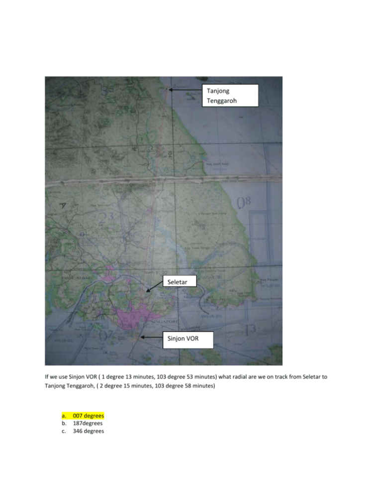
Tanjong Tenggaroh Seletar Sinjon VOR If we use Sinjon VOR ( 1 degree 13 minutes, 103 degree 53 minutes) what radial are we on track from Seletar to Tanjong Tenggaroh, ( 2 degree 15 minutes, 103 degree 58 minutes) a. b. c. 007 degrees 187degrees 346 degrees Distance: 48 Nautical Miles If a pilot tracks from Seletar to Tanjong Tenggaroh using Singjon NDB, what is the distance between the two? a. b. c. 38 48 55 Flashing once every 10s At Tanjong Tenggaroh, there is a lighthouse that flashes? a. once every 10 seconds b. 2 flashes every 10 seconds c. 3 Highest elevation What is the highest elevation on the map? a. 6914(AGL) b. 7100(AGL) c. 6914(MSL) Seletar Airport Singapore Airport All of which are marked with a ‘J’ Which airport has jet facilities? a. Singapore airport b. Changi airport and Seletar airport c. Changi airport, Singapore airport and Seletar airport Changi Airport Kong Kong NDB 11nm from Singapore airport (01 degrees 21’N, 103 degrees 55’) is an NDB Kong Kong. What is its grid reference in terms of lat and long to the nearest minute? a. 01 degrees 31’, 103 degrees 59’ b. 01 degrees 32’, 104 degrees 00’ c. 01 degrees 30’, 103 degrees 58’ Highest elevation In the grid square of 3 degrees 20’ – 4 degrees 00’ N and 102 degrees 00’ – 102 degrees 30’ N, what is the point of highest elevation? a. 6914 feet b. 69140 feet c. 6914 meters 765 feet AMSL The highest point on Singapore Island is: a. 764m(AGL) b. 435feet(AMSL) c. 765feet(AMSL) Sinjon NDB On the map is Sinjon 01 degrees 13’, 103 degrees 51’(VOR) and Tanjong Penang 00 degrees 55’, 104degrees 32’(NDB). What radial would you be on to fly from Tanjong Penang to Sinjon. a. 296 from Sinjon with drift b. 104 from Sinjon c. 296 from Tanjong Penang Tanjong Pinang 7100 feet with 100feet error The highest maximum elevation data on the map? a. 7100 feet with 100 feet error b. 7100 feet with 250 feet error c. 7100 feet with 100m error 65 feet AMSL Singapore Airport (01 degrees 2’, 103 degrees 55’ ) elevation is? a. 65 agl feet b. 65 msl feet c. Not given Since Changi, Singapore and Seletar Airport has jet facilities, the answer is to this question is Sembawang and Tengah airport. On Singapore island, there are 5 airports, Changi, Singapore, Seletar, Sembawang and Tengah. Which of these do not have jet facilities? a. Singapore only b. Sembawang and Tengah c. Singapore, Seletar and Changi Kluang, Length of runway is 4100ft Elevation of Kluang is 150ft AMSL Kluang, 2 degrees 3minutes and 103 degrees 19 minutes is designated at /41/ . What is the length of the runway? a. 410m b. 4100m c. 4100ft What is the elevation of Kluang? a. 150ft agl b. 150m msl c. 150ft msl The length of Tebrau Runway is 3000ft The elevation of Tebrau is 70ft Co-ordinates , 1 degree 31 minutes N, 103 degree 47 minutes E., Tebrau, What is the designated runway length and elevation of the aerodrome? a. 3000ft, 70m b. 3000m, 70ft c. 3000ft, 70ft Tioman The track touches the coastline at 103 degrees 49 minutes, 2 degrees 32 minutes Pakloh A track from Tioman (2 degrees 48 minutes, 104 degrees 10 minutes), Pakloh (2 degrees 10 minutes, 103 degrees 24 minutes) is plotted. What is the coordinates where the track touches the coast line? a. 103 degrees 49 minutes, 2 degrees and 32 minutes b. 104 degrees 50 minutes, 1 degrees and 32 minutes c. 103 degrees 60 minutes, 2 degrees and 23 minutes Segamat The coordinates 102 degrees 52 minutes, 2 degrees 29 minutes, Segamat. What is the highest point 5nm of the point? a. 2017 ft b. 3126 ft c. None, no spot height present Highest spot, 6914ft to the nearest 100ft In the grid square bounded by (3 degrees 30’, 4 degrees) and (102 degrees, 102 degrees 30’) . what is the highest spot height found inside? a. 6914ft to the nearest 250ft b. 6914ft to the nearest 100ft c. 1499m to the nearest 100m Sinjon NDB The distance is 44.8 Nautical miles Tanjong Pinang The distance from Tanjong Pinang NDB to Sinjon NDB is? a. 30nm b. 44.8nm c. 83nm Segamat Highest spot, 3126 feet Pakloh A direct track is drawn from Segamat Aerodrome to Pakloh Aerodrome. Within 10nm of the track, what is the highest spot height? a. 3126 b. 3328 c. 2700 Gemas Kluang A direct track is draw from Gemas aerodrome to Kluang Aerodrome. What is the highest grid height a. 3500 b. 4300 Singapore Airport Sinjon NDB A direct track is drawn from Singapore Airport to Sinjon NDB, what is the radial to Sinjon? a. 204 degrees + drift b. 024 degrees c. 204 degrees A direct track is drawn from Singapore to Sinjon VOR. What is the Sinjon radial? a. 204 degrees b. 204 degrees with drift. c. 024 degrees Flying from Singapore to Sinjon, true track? a. 204 b. 204 with drift c. 24 425 feet AMSL, 350 feet AGL What is the height of the vertical obstruction at the coordinates 1 degrees 31 N 103 degrees 48 E (Refer to legend – Parenthesis = brackets) a. b. c. d. 425 ft above ground level 350 ft height above ground elevation 425 ft above mean sea level 350 ft height above ground elevation 350 ft is the height of the obstruction and 450 ft ground level 1100 4.5 inch on a 1:500 000 map represents? a. b. c. 30.84 miles 29 miles 34.8 miles If number in the centre represents highest point in grid rounded off to the nearest 100 and has an error of 100 or 250. What should ‘DOT’ 2515 mean? a. b. c. 26 27 28 Along the track you came across a specially demarcated zone, R-26 it means? a. b. c. Control zone with unlimited height Danger zone up to 2600 feet Restricted up to 26000 feet At 5 degrees from the equator, compass will experience? a. b. c. Acceleration error Liquid swirl error Acceleration error, tuning error and liquid swirl error 123nm is ______km _____ sm 1nm=1.852km 123nm=123x1.852=227.8 1nm=1.15sm=141.45 a. b. c. 123km, 231sm 228km, 138sm(closest) 228km, 256sm Convert 3003 ft to ______m 1ft=3.28ft 1ft=3003/3.28=915.5m a. b. c. 916m 619m 911m On a lambert chart, as you move away from the equator, the distance that represents longitude is? a. b. c. Increased Reduced Constant latitude is expanded The annual rate of change of variation for Singapore is? a. b. c. 1’E 1 degree E negligible What is C heading if T is 336, 5 W variation and a compass deviation of t2. a. b. c. 341 343 339 336+5-2=339 Point A and B are 115nm apart. An aircraft takes from Point A at 1115 and due to the presence of clouds, the pilot changes its heading to 5˚ to the right. At 1128 the aircraft has past the clouds and the pilot then changes the aircraft’s heading so that it now travels parallel to the original track from Point A to B. At 1201 the aircraft is about 30nm from Point B. (i) what should the aircraft’s heading be changed by to track to Point B and (ii) what is the ETA to Point B? a. b. c. (i) 2˚ port (ii) 1220 (i) 4˚ port (ii) 1217 (i) 5˚ starboard (ii) 1233 Convert 6500ft to m 6500ft/3.28=1981.7 a. b. c. 65000m 1891m 1981.2m TAS is 135 kt with head wind 8 kts. At 8 gallons/hr fuel consumption, we get a. b. c. 15.9nm/gallon 30nm/gallon 17.9nm/gallon At FL 60, temp +2 degrees C, what is TAS is RAS is 127 a. b. c. 110 128 138 ______________________________________________________________________________ At the mid latitudes, there is an acceleration error. This error is a. b. c. Zero at the equator, max a mid latitudes, and zero at the poles Zero at magnet equator, max at poles Same in the N and S hemisphere ***When is acceleration errors of the compass are? a) minimum at the magnetic equator and maximum at the poles b) minimum at the magnetic poles and minimum at it’s equator c) same throughout both hemisphere ______________________________________________________________________________ Metallic objects are advised not to be put near a magnetic compass. This advice refers to? a. b. c. d. Magnetised object but non-magnetised objects have no effect Only to objects placed in the horizontal plane of the magnetic compass Objects in the plane of compass at the equator Magnetised and non-magnetised objects placed anywhere near the compass The map has a scale of 1:500 000. What would 11.5 cm on the map be 11.5cm is approx 4.5 inch a. 10.2 nm b. 50.1 nm c. 31.0 nm 7 inch on a 1:500000 map represents? 4.5 inches = 30.84nm 7 inches= (30.84/4.5)x7=47.9 a. b. c. 48.7(closest) 24.2 50 something On a Lambert chart, mid latitudes, straight tracks from west to east, where should angle between track & line of longitude be taken? a. b. c. Mid pt. Of track Pt of departure Anywhere as the angle is always the same On the chart given, the longitude and latitude graticule are virtually a square. On a orthomorphic chart (such as the lambert’s chart) the distance between the meridians: a. decreases b. increases c. remains constant but the distance between the parallel lines of latitude increases The distance between Point A and Point B is 99nm. You set off at point A at 0915. At 0953, you are 30nm from Point A and you find yourself 2nm right of the track. By how much must you change your heading to track towards Point B? a. 5 port (left) b. 6 port (left) c. 2 port (left) At what time you will arrive at Point B? (you may use the 1 in 60 rule) a. 1018 b. 1017 c. 1019 Assuming that fuel consumption is 24litres per hour, how much fuel will you consume if you fly 185nm at a groundspeed of 132kts? a. 33.6litres b. 33.01litres c. 17.1litres The grid elevation is calculated with an error of 100ft with respect to the spot elevation. Spot elevation has an error of 100ft or 250ft. What would be the grid elevation be when the highest spot elevation of a grid is ·2515 a. 2600 b. 2700 c. 2800 What is the TAS of an aircraft it is flying at FL 35 at 15°c at and IAS of 130kts a. 128kts b. 138kts c. 148kts Given that the track is 141° and the drift is 7° left. Find the wind direction and velocity if the TAS is 115kts and groundspeed of 120kts a. 260° 15kts b. 085° 35kts c. 085° 15kts Convert 1550m to feet. 1550x3.28=5084 a. 5084ft b. 472.6ft c. 5239ft An airplane flies at 9 metres per second, what is its speed in knots? 9x3600=32400 & 32400/1852=17.49 a. b. c. 17.4 33.6 26.3 ______________________________________________________________________________ Metallic objects are not to be placed near the magnetic compass as? a. magnetised object will attract the compass needle and unmagnetised object will repel b. magnetised object will repel the compass needle and unmagnetised object will attract c. only until a compass swing is done, the error can be recognized Metallic objects are not to be placed near the magnetic compass, it is true to say that: a) magnetized objects will attract the compass needle & unmagnetised objects will repel the needle b) magnetized objects will repel the compass needle & unmagnetised objects will attract the needle c) only until a compass swing is done, the error cannot be recognized. A metallic object placed in close proximity to the compass in the aircraft may affect its reading and accuracy. In what ways will the object affect it? a. b. c. A magnetised object will attract the compass needle and an unmagnetised object will repel it. An unmagnetised object will attract the compass needle and a magnetised object will repel it. A compass swing is required to determine accurately the exact effect that the objects will have on the compass needle. ______________________________________________________________________________ One minute of latitude is approximately? a) 60nm b) 30nm c) 1nm 11.5 cm on a 1:500000 map represents? 1inch=2.54cm…11.5/2.54=4.527inch a) 31 nm b) 29 nm c) 30 nm Given- heading 089°, 2° right drift heading 045°, 5° right drift heading 030°, 3° right drift w/v? a) 105/15kts b) 285/25kts c) 106/16kts With an outside air temperature of -10c at an altitude of 6000ft, if your rectified airspeed is 140kts, your TAS would be? a) 138kts b) 132kts c) 150kts Aircraft flying at TAS 117 kts, G/S 120 kts, heading 166 degrees (T) with 7 degrees port drift. What is the W/V: a) 085 degrees, 15 kts b) 085 degrees , 5 kts c) 260 degrees, 15 kts(I get 271 deg) 15nm equates to? 15x1.15=17.25sm & 15x1.852=27.78km a. b. c. 13sm and 28km 13sm and 27.8km 17.3sm and 27.8km 3300ft represent? 3300/3.28=1006.09m a. b. a. 330m 1006m 981m At mean sea level, ISA conditions are defined as a) Pressure 1013.2HPa, falling at 30HPa(mb)/1000ft, temperature +15, density 1225gm/cubic metre b) Pressure 1013.2HPa, temperature +15, decreasing at a rate of 1.98C/1000ft up to 36090ft, density 1225gm/cubic metre c) Pressure 1000HPa What does 7.5 inches on a 1:50000 map represents on ground? (30.84/4.5)x7.5=51.4 a. 49 nm b. 51.4 nm c. 61 nm Given track: 196 w/v: 035/15ktstas: 128 What is the IAS? a. 141 b. 138 c. 145 An aircraft consumes 12 gallons of fuel per hour. If it travels at a speed of 135 knots with a headwind of 8 knots, what is the distance traveled per gallon of fuel? (135-8)/12=10.58 a. 10.6nm/gallon. b. 12.3nm/gallon. c. 11.4nm/gallon. Required track: 213˚(T) Drift: 8˚ port Magnetic Variation: 6˚W Compass deviation: +2˚ 213+8+6-2=225 Therefore the compass heading should be: a.217˚ b.225˚ c.213˚ If compass heading is 193º, variation 5º West and deviation +3º; what is true heading? 193-5+3=191 a. 191º b. 201º c. 185º ***Aircraft need to 64litre travel 96nm . he took 25% extra , 80litre .After traveling 10mins he found that he has 70 litre left . after 20 mins he found that he has 52 litre left .he still got 50nm to reach (should be) .. is he able to reach destination a. there is insufficient fuel to complete the flight b. can reach with significant portion of reserve used. c. Can reach with 25% reserve unused When flying a track 235°, there is a drift of 8degrees Port, variation 6° W, deviation +2. What is the compass heading to fly? My ans. is 247 a. b. c. 245 237 241 Heading (T):113o Drift: 8o port Magnetic Variation: 6oW Deviation: +2 a. b. c. 117o 121o 125o 113+6-2=117 Variation of the map is d. e. f. 1/2º East, constant 1/2º East, increasing 1º West, increasing ***On a chart of scale 1:500 000, it takes 30mins to travel 20km. Flying at same speed, how long does it take to travel 20cm on a chart of scale 1:250 000 From my calculations, it should be 75 min 10cm on a 1:500000 1 inch = 2.54cm 10/2.54=3.937inch & 20km/1.852km=10.8nm 3.937inch=27nm, hence 27/10.8x30min=75min a) 60 min b) 30 min c) 15 min If I want to fly a track of 215 degrees and there is drift of 8 degrees (P), magnetic variation of 6 degrees W, compass deviation of +2, what is the compass heading to fly? d. e. f. 215+8+6-2=227 215 217 231 The compass deviation is +2°. What is the compass heading for a place tracking 137°(T), with a variation of 4°W? 137+4-2=139 a. 143° b. 141° c. 139° TAS 135 GS 137 TR 166 (T) DRIFT 8R ( Starboard) find WV/Heading My ans. 065 20kts a.065 10Kts b.260 20Kts c. 085 20Kts Given Heading 296˚(T), w/v 035˚/15kts, TAS 147kts. Find Track. a. b. c. 291˚ 292˚ 290 w/v 035/ 15knot, 145 knot TAS, Track 296 Find heading a. 290 b. 291 c. 302 What does 425 (350) represent? a. b. c. The elevation of the terrain is 75 ft msl The elevation of the terrain is 70 ft msl The elevation of the terrain is 75 ft agl What is the height of the vertical obstruction at the coordinates 1°31 N 103° 48 E (refer to legend – parenthesis = brackets) a. 425 ft above ground level 350 ft height above ground elevation b. 425 ft above mean sea level 350 ft height above ground elevation c. 350 ft is the height of the obstruction and 450 ft above ground level d. 1100 A vertical obstruction (1°31’N, 103°47’E) on the map indicates that it is a. 350 feet agl on a site that is 75 feet amsl The compass can be affected by metallic objects and can sometimes give very erratic readings. To prevent this, pilots must ensure not to place metallic objects near the compass. This applies to a. objects placed in the same plane as the compass b. objects placed in any direction and in the same plane as the compass c. objects place fore and aft of the compass Aircraft going from P-Q 87 nm departing 1210 . at 1225 he discover he has cover 29 nm over ground 2m left of track. What heading should he turn and time reaching ??? a. b. c. 6 right 1255 4 right 1257 2 right . From the road from Seletar to Tanjong Tenggaroh, there is an area marked WS/(R-29) a) Restricted area to 29000ft b) Danger, restricted or prohibited area to 29000ft From Seletar to Tanjong Tenggaroh, what is the track and distance? c) 068 deg, 50nm An airplane flies 9m/sec, how many knots does it fly at? d) 324 If the compass heading is 393, variation 5deg west, and deviation of +3, what is the true heading? a) 395 deg b) 391 deg c) 385 deg A pilot notices the following drifts with constant TAS of 155: 089 2deg South 036 4deg South 326 3deg South What is the wind velocity? e) 162 7kts f) 282 15kts g) 164 15kts When on a position away from the equator, acceleration errors and turning errors are maximum a. N & W, E & W b. E & W, N & S c. N & W, E & S When on a position away from the equator, turning errors and acceleration errors are maximum a. N & W, E & W b. E & W, N & S c. N & W, E & S d. N&S,E&W
