Teacher`s Notes - Amazon Web Services
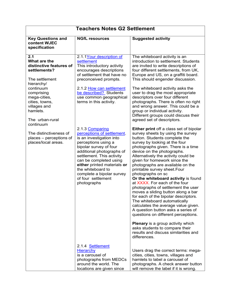
Key Questions and content WJEC specification
2.1
What are the distinctive features of settlements?
The settlement hierarchy/ continuum comprising mega-cities, cities, towns, villages and hamlets.
The urban-rural continuum
The distinctiveness of places – perceptions of places/local areas.
Teachers Notes G2 Settlement
NGfL resources Suggested activity
2.1.1
Your description of settlement
This introductory activity encourages descriptions of settlement that have no preconceived prompts.
2.1.2 How can settlement be described? Students use common geographical terms in this activity.
2.1.3 Comparing perceptions of settlement . is an investigation into perceptions using a bipolar survey of four additional photographs of settlement. This activity can be completed using either printed materials or the whiteboard to complete a bipolar survey of four settlement photographs
2.1.4 Settlement
Hierarchy is a carousel of photographs from MEDCs around the world. The locations are given since
The whiteboard activity is an introduction to settlement. Students are invited to write descriptions of four different settlements, from UK,
Europe and US, on a graffiti board.
This should engender discussion.
The whiteboard activity asks the user to drag the most appropriate descriptors over four different photographs. There is often no right and wrong answer. This could be a group or individual activity.
Different groups could discuss their agreed set of descriptors.
Either print off a class set of bipolar survey sheets by using the survey button. Students complete the survey by looking at the four photographs given. There is a time device on the photographs.
Alternatively the activity could be given for homework since the photographs are available on the printable survey sheet.Four photographs on sc
Or the whiteboard activity is found at XXXX. For each of the four photographs of settlement the user moves a sliding button along a bar for each of the bipolar descriptors.
The whiteboard automatically calculates the average value given.
A question button asks a series of questions on different perceptions.
Plenary is a group activity which asks students to compare their results and discuss similarities and differences.
Users drag the correct terms: megacities, cities, towns, villages and hamlets to label a carousel of photographs. A check answer button will remove the label if it is wrong.
2.2
How does the social and cultural structure of settlements vary
[and why]?
Pattern of intra-urban migration leading to ghettoisation and student districts.
Social patterns and diversity of life styles that are influenced by both human and physical factors.
2.3
What are the issues of the inner-city?
[2.2 The reasons for re-urbanisation.]
The reasons why regeneration is considered appropriate including deindustrialisation, dereliction, wasteland this is often significant in allocating the correct term. e.g. a town in Greenland could be a smaller size than a village in Japan.
2.2.1 Intra Urban Migration is an interactive resource linking social groups to differing housing types and urban zones.
Answers are available for reasons for the patterns.
Impacts of studentification is a carousel of images of student life style. A matrix of social, economic, environmental impacts is available for completion either on the whiteboard or as a printed sheet.
Opinions on
Studentification
Distribution of students in
Chester provides the base map and data to develop a choropleth map. This can be completed using either the whiteboard or a printed sheet.
As a possible answer, the key button gives a suggested grouping and a completed map.
There is a separate
Teacher’s notes in
A virtual field trip investigation, Liverpool
Dockland
Users drag the appropriate images of housing types and urban zones beneath the photographs of different social and cultural groups.
Discussion on answers different to those given on the screen will develop critical ideas on simple urban models. Discussion should end by deciding how intra-urban migration leads to the development of student districts.
Users are asked to use the whiteboard to suggest reasons for the social patterns shown.
Initial discussion of student life and its impacts prompted by the images leads to the completion of a matrix on impacts.
Given the base map and data, users are asked to develop and justify the size of classification groups to produce a suitable choropleth map.
A discussion of the distribution could follow.
A virtual field investigation of
Liverpool Dockland regeneration
and social exclusion and global economic changes.
Evaluation of the success of regeneration schemes in social, economic and environmental terms
2.4
What are the issues being faced in the
CBD?
The issues of access, pedestrianisation, entertainment districts, uniformity of retailing, office districts and transport.
An understanding of the necessity of maintaining / enhancing a vibrant retailing experience in the face of competition from other retail locations away from the CBD and from the
Internet.
2.5
How is the ruralurban fringe changing [and why]?
The pressures on green belts from recreation (golf and stadia), retailing and business/ office parks and government housing targets, bypasses and ring road developments.
There is a separate
Teacher’s notes in
Investigation: To what extent will Liverpool ONE compete with out of town and internet retail?
The case study of
Chester is used but throughout the activities students are also directed to develop their own local examples.
What land uses would you expect in the rural urban fringe?
is an interactive introductory activity to identify the type and location of different land uses.
The rural -urban fringe of
Chester has a map of
Chester with hot spots.
A secondary investigation of
Liverpool ONE, a CBD retail development
Users are asked to drag activities to an appropriate area within the rural urban continuum.
Users click on individual hotspots for a photograph of the land use.
By clicking on the correct symbol at
Evaluation of the impact of changes.
2.6
How are rural settlements changing and why?
Perceptions of rurality.
Each of the 13 hot spots marks a photograph with a land use classification activity.
A further activity ? [add symbol] suggests the development of a similar local map.
How would you investigate change in the urban rural fringe of your local area?
The aim of this tabular resource is to develop students’ investigative design skills.
The table can be completed using either the whiteboard or a printed sheet.
Suggested answers are given
What is the impact of changing urban rural land use of Chester?
This activity gives case study material to add to the experiences in a local area.
A carousel of the differing land use photographs of the Chester rural-urban fringe and a map of their location provide resources for the activity which is completed on a printed maitrix. More detail can be added to the answer by referring to the fact sheets xx
Virtual Field
Investigation into the impact of
Counterurbanisation on a village. Case study- the base of each photograph a classification of the land use will appear on the map.
A further activity ? [add symbol] directs students into developing a land use map of their local ruralurban fringe. It suggests drawing a local map from google and gives a list of categories of land use to find and mark on their own map.
Students are asked to complete either the on whiteboard or on a printed sheet a maitrix by identifying appropriate primary data collection techniques and appropriate secondary data collection techniques.
This could be followed by students completing an investigation in their own area.
Students complete a printed maitrix of the social, economic, environmental impacts shown by the carousel of photographs. This should be completed first from their own opinions from the photographs then completed from the fact sheets xx
Students should then evaluate this maitrix.
[in 2.1]
[ 2.2The reasons for counter urbanisation]
The nature of rural settlements and changing rural settlements to include peripherality, isolation, abandonment; second homes, homes for local employees and retirement; employment; retailing and service provision.
The changing social profile of settlements.
The social impacts of the changing rural economy
Rhydymwyn
Through resources of: census data; old and newer maps; satellite image; building photographs; excel file of results of a questionnaire survey students investigate the impact of counterurbanisation
[Liverpool] on a village in
NE Wales
Suggest why the population of Rhydymwyn is increasing.
gives census data and satellite images.
How has the aerial pattern of Rhydymwyn changed
1972 -2007?
Maps of the two dates are given. An outline map of the village provides a base map for the activity.
How has the land use within Rhydymwyn changed?
A map of the village with hot spots linked to photographs provides the resources for the activity.
How has the social profile in Rhydymwyn changed?
What are the social impacts of the changes?
A spread sheet of the results of a questionnaire completed in 2007 provides the field data to answer these questions.
Secondary investigation into other social changes in rural settlements a series of research activities based on internet, newspaper, photo report, video clips
Students are asked to analyse changing population statistics. From the satellite image of NE Wales they are to suggest pull factors to the region.
Students are asked to show, and describe, the growth of the village between the two dates on the base map.
Students are asked to classify different land uses from the photographs, insert land use zones on the base map and describe land use in the village 2007.
A series of detailed questions guide the student through the analysis of an excel file of questionnaire results designed to investigate social changes in a village.
Secondary research activities into peripherality, isolation, abandonment; second homes.
Students are asked to develop flow diagrams to show knock on effects.
