Geography of China and Japan
advertisement
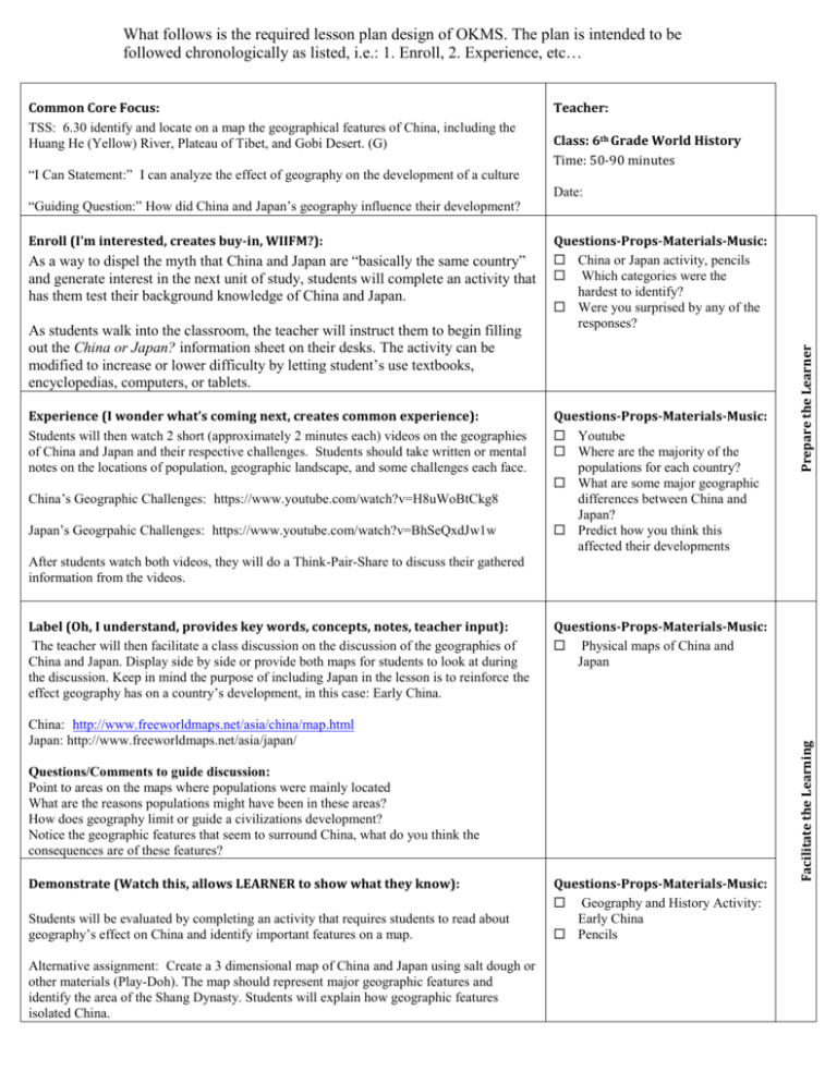
What follows is the required lesson plan design of OKMS. The plan is intended to be followed chronologically as listed, i.e.: 1. Enroll, 2. Experience, etc… “I Can Statement:” I can analyze the effect of geography on the development of a culture “Guiding Question:” How did China and Japan’s geography influence their development? Enroll (I’m interested, creates buy-in, WIIFM?): As a way to dispel the myth that China and Japan are “basically the same country” and generate interest in the next unit of study, students will complete an activity that has them test their background knowledge of China and Japan. As students walk into the classroom, the teacher will instruct them to begin filling out the China or Japan? information sheet on their desks. The activity can be modified to increase or lower difficulty by letting student’s use textbooks, encyclopedias, computers, or tablets. Experience (I wonder what’s coming next, creates common experience): Students will then watch 2 short (approximately 2 minutes each) videos on the geographies of China and Japan and their respective challenges. Students should take written or mental notes on the locations of population, geographic landscape, and some challenges each face. China’s Geographic Challenges: https://www.youtube.com/watch?v=H8uWoBtCkg8 Japan’s Geogrpahic Challenges: https://www.youtube.com/watch?v=BhSeQxdJw1w Teacher: Class: 6th Grade World History Time: 50-90 minutes Date: Questions-Props-Materials-Music: China or Japan activity, pencils Which categories were the hardest to identify? Were you surprised by any of the responses? Questions-Props-Materials-Music: Youtube Where are the majority of the populations for each country? What are some major geographic differences between China and Japan? Predict how you think this affected their developments Prepare the Learner Common Core Focus: TSS: 6.30 identify and locate on a map the geographical features of China, including the Huang He (Yellow) River, Plateau of Tibet, and Gobi Desert. (G) After students watch both videos, they will do a Think-Pair-Share to discuss their gathered information from the videos. Questions-Props-Materials-Music: Physical maps of China and Japan China: http://www.freeworldmaps.net/asia/china/map.html Japan: http://www.freeworldmaps.net/asia/japan/ Questions/Comments to guide discussion: Point to areas on the maps where populations were mainly located What are the reasons populations might have been in these areas? How does geography limit or guide a civilizations development? Notice the geographic features that seem to surround China, what do you think the consequences are of these features? Demonstrate (Watch this, allows LEARNER to show what they know): Students will be evaluated by completing an activity that requires students to read about geography’s effect on China and identify important features on a map. Alternative assignment: Create a 3 dimensional map of China and Japan using salt dough or other materials (Play-Doh). The map should represent major geographic features and identify the area of the Shang Dynasty. Students will explain how geographic features isolated China. Questions-Props-Materials-Music: Geography and History Activity: Early China Pencils Facilitate the Learning Label (Oh, I understand, provides key words, concepts, notes, teacher input): The teacher will then facilitate a class discussion on the discussion of the geographies of China and Japan. Display side by side or provide both maps for students to look at during the discussion. Keep in mind the purpose of including Japan in the lesson is to reinforce the effect geography has on a country’s development, in this case: Early China. Questions-Props-Materials-Music: Geography handout While going over the questions with students, be sure to highlight how even though the geographic features of both China and Japan seem to “isolate” them from the rest of the world, the reality is that both countries still had contact with other cultures. At times, that contact was more limited than at other points in history. Celebrate (I did it! Acknowledge completion, participation, and acquisition of skills/knowledge): Scholar Bucks (correct answers, behaviors, ideas, etc) Yollars for On time and On task (coming in quietly and beginning warm up) 123 Power Whoosh (correct answers or good ideas during discussion) Questions-Props-Materials-Music: Liveschool (online behavior management app) used to give Yollars (school currency) Scholar bucks (classroom currency/reward) Resources used: 1. China or Japan Handout 2. Youtube a. China https://www.youtube.com/watch?v=H8uWoBtCkg8 b. Japan https://www.youtube.com/watch?v=BhSeQxdJw1w c. Both videos produced by Stratfor: Global Intelligence ( https://www.stratfor.com/) 3. Physical maps: a. China: http://www.freeworldmaps.net/asia/china/map.html b. Japan: http://www.freeworldmaps.net/asia/japan/ c. Both maps from www.freeworldmaps.net 4. Geography and History Activity Handout produced by McGraw-Hill networks Solidify the Learning Review (I know it! I know it! Solidify learning): If time allows, as a class, review the questions from the activity.


