Chapter 4 Assignment GEarthOL
Geology 110: Earth and Space Science
Chapter 4 (Plate Tectonics) Homework
SELF-REFLECTION AND COMPREHENSION SURVEYS
Section 4.1:
Answer the following questions as a means of uncovering what you already know about paradigm shifts and plate tectonics.
1.
Name a state or province where you could a.
Find an active volcano.
b.
Have a good chance to experience an earthquake.
c.
Climb a mountain of over 3,000 meters (about 10,000 feet) in elevation.
2.
Using examples that are not described in this chapter, indentify and briefly describe a.
a personal paradigm shift.
b.
a scientific paradigm shift.
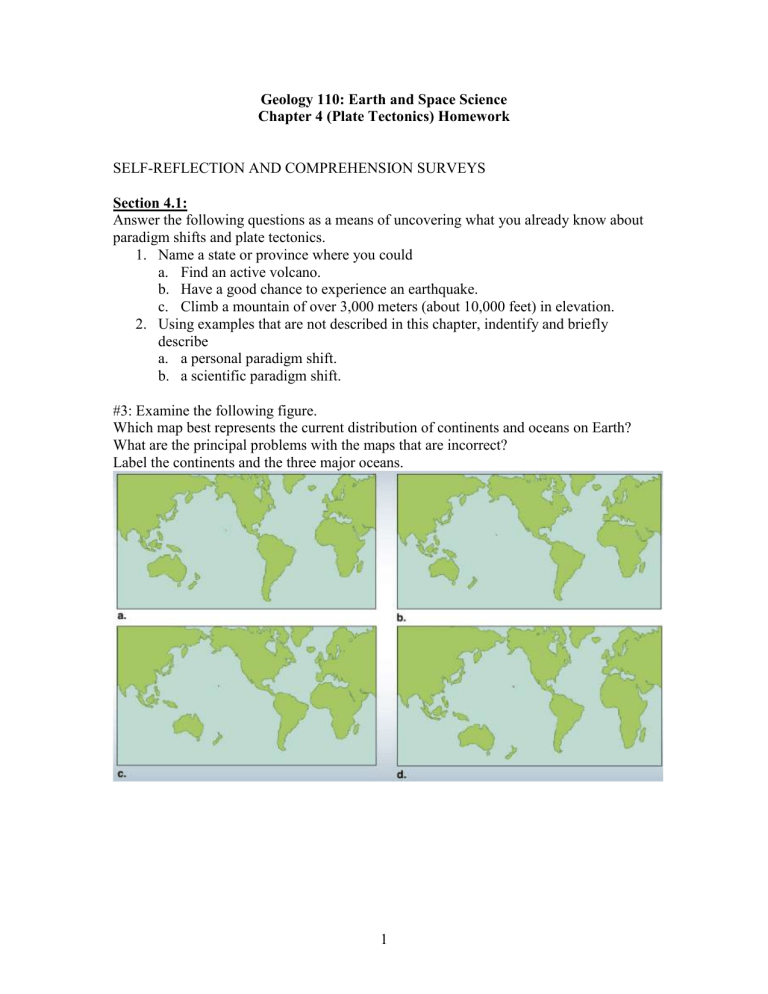
#3: Examine the following figure.
Which map best represents the current distribution of continents and oceans on Earth?
What are the principal problems with the maps that are incorrect?
Label the continents and the three major oceans.
1
Checkpoint 4.2, 4.1, p. 78
#4: Which of these lines of evidence were used to support Wegener’s continental drift hypothesis (select all that apply)? a) The distribution of fossils b) Fit of continents c) Match of mountain belts d) Earthquake locations e) Paleoclimate data
#5: What type of reasoning did Wegener use in developing his continental drift theory? a.
Inductive b. Deductive c. Both
Explain your reasoning:
Checkpoint 4.4, p. 80
#6: Write a paragraph that argues for or against the following statement:
Development of the hypothesis of continental drift was consistent with the characteristics of good science.
Checkpoint 4.5, p. 81
#7: After examining the diagram that follows, determine which pair of locations has oceanic trenches. a) A, C b) D, F c) B, E d) G, H
2
Checkpoint 4.13, p. 92
#8: Draw the approximate location of the plate boundaries on the following map. Use different line symbols for the oceanic ridges and oceanic trenches. Name and label as many of the plates as you can.
Checkpoint 4.7, p. 83
#9: Compare and contrast patterns of: (1) topography of the ocean floor, (2) age of the ocean floor, (3) heat flow, (4) volcanic activity, and (5) earthquake activity for ocean ridges and ocean trenches using figures 4.5, 4.6, 4.7 and 4.8. The matrix below is a good way for you to organize this information ( you don’t have to use it but should provide a comparable response) . It is best to work on this checkpoint after you have read the chapter and completed checkpoint 4.13 (above). FOR EXAMPLE (many students struggle with this question but it’s important to understand these patterns): number
4 above is patterns of volcanic activity: so think about this, where are volcanoes generally located? Are they found at divergent boundaries? (YES, this is where seafloor spreading begins, where new oceanic crust is created at the ridges which are all volcanic!; next, are they found at transform boundaries (like the San
Andreas?)-NO, here the plates move side by side and keep a lid on the asthenosphere where most of the melting takes place providing magma for volcanic eruptions; finally, are they found at convergent boundaries? YES-very explosive ones (like Mount St. Helens) are found at oceanic-continental convergent zones; also, explosive ones like in Japan (Mt Fuji) are found at oceanic-oceanic convergent zones; BUT volcanic activity isn’t common at continental-continental convergent boundaries (like where India pushes into Eurasia creating the Himalayas which are mostly non-volcanic). So you can track this below with “X”s in the appropriate boxes or write it out-whatever works for you to understand these concepts.
Plate Tectonics Defining Features Matrix
3
Boundary
Type
Characteristic
High heat flow
Youngest Seafloor age
Shallow (0-30 km) earthquakes along narrow band
Shallow (0-30 km) earthquakes along wide band
Moderate depth earhquakes (30-
300 km)
Deep earthquakes
(300+ km)
Earthquakes get deeper in one direction
Only shallow and moderate depth earthquakes
Trench
Seafloor gets shallower
Divergent
Ocean-
Ocean
Convergent
Ocean-
Continent
Convergent
Continent-
Continent
Convergent Transform
High Mountains
Volcanic Island
Arc
Chain of
Volcanoes on land
Plates move together
Plates move apart
Plates slide past one another
Checkpoint 4.9, p. 85
#10: Which United States’ location has the greatest magnetic inclination value (that is, closest to vertical)? a) Anchorage, Alaska b) New York, New York c) Miami, Florida d) Imperial, California
4
Checkpoint 4.17, p. 99
#11: On the following map, the patterned areas labeled X, Y, and Z represent continents; assume the rest of the map is ocean.
-How many plates are present? ________ a) 3 b) 4 c) 5 d) 6
-Draw arrows on the map showing the relative directions of plate motions.
-We could add a series of volcanoes associated with one of the plate boundaries. Which boundary would it be and why?
5
Checkpoint 4.19, p. 106
#12: Venn Diagram: Divergent versus Convergent Plate Boundaries
Use the following Venn diagram to compare and contrast divergent and convergent plate boundaries. Three characteristics of plate boundaries are provided. Identify at least 7 more. Then write the numbers of the features unique to either group in the larger areas of the left and right circles; note features that they share in the overlap area in the center of the image.
Divergent Plate Boundaries Convergent Plate Boundaries
1.
Rocks on either side of boundary are typically of different ages.
2.
Example: Nazca and South American plate boundary.
3.
Associated with oceanic trenches.
4.
5.
6.
7.
8.
9.
10.
6


