M - St. Joseph River Watershed
advertisement
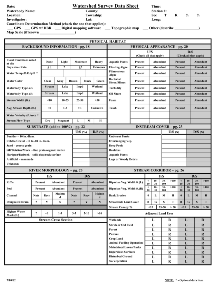
Date: Watershed Survey Data Sheet Waterbody Name: County: Location: Township: Investigator: Lat: Coordinate Determination Method (check the one that applies): ___ GPS ___ GPS w/ DBR ___ Digital mapping software ___ Topographic map Map Scale (if known ___________________) PHYSICAL HABITAT BACKGROUND INFORMATION - pg. 18 Time: Station #: Sec T Long: R ¼ ___ Other (describe _____________) PHYSICAL APPEARANCE - pg. 20 U/S D/S (Check all that apply) Event Conditions noted at site Days since Rain ¼ (Check all that apply) None Light Moderate Heavy Aquatic Plants Present Abundant Present Abundant ≤1 2 ≥3 Unknown Floating Algae Filamentous Algae Bacterial Sheen/Slimes Present Abundant Present Abundant Present Abundant Present Abundant Present Abundant Present Abundant Water Temp./D.O./pH * Water Color Clear Gray Brown Black Green Waterbody Type-u/s Stream Lake Impd Wetland Turbidity Present Abundant Present Abundant Waterbody Type-d/s Stream Lake Impd Wetland Oil Sheen Present Abundant Present Abundant Stream Width (ft.) <10 10-25 25-50 >50 Foam Present Abundant Present Abundant Avg. Stream Depth (ft.) <1 1-3 >3 Unknown Trash Present Abundant Present Abundant Water Velocity (ft./sec) * Stream Flow Type Dry Stagnant L M SUBSTRATE (add to 100%) – pg. 22 U/S (%) H INSTREAM COVER – pg. 23 U/S (X) D/S (%) Boulder – 10 in. diam. Undercut Banks Cobble/Gravel –10 to .08 in. diam. Overhanging Veg. Sand – coarse grain Deep Pools Silt/Detritus/Muck - fine grain/organic matter Boulders Hardpan/Bedrock – solid clay/rock surface Aquatic Plants Artificial – manmade Logs or Woody Debris D/S (X) Unknown RIVER MORPHOLOGY – pg. 23 U/S STREAM CORRIDOR – pg. 26 D/S U/S 1030 1030 30100 30100 >100 Bank Erosion 0 L M Streamside Land Cover B G S Riffle Present Abundant Present Abundant Riparian Veg. Width ft.(L) Pool Present Abundant Present Abundant Riparian Veg. Width ft.(R) Channel Designated Drain Natr Recv Maintn d Natr Recv Maintn d ? Y N ? Y N Stream Canopy % Highest Water Mark (ft.) ? <1 1-3 3-5 Stream Cross Section 5-10 <25 25-50 < 10 < 10 1030 1030 30100 30100 >100 H 0 L M H T B G S T >100 > 50 <25 >100 25-50 > 50 Adjacent Land Uses >10 Wetlands Shrub or Old Field Forest Pasture Crop Land Animal Feeding Operation Maintained Lawns/Parks Impervious Surfaces Disturbed Ground No Vegetation 7/10/02 D/S < 10 < 10 L L L L L L L L L L R R R R R R R R R R L L L L L L L L L L R R R R R R R R R R NOTE: * - Optional data item Watershed Survey Data Sheet Date: (pg. 2) Station #: ROAD CROSSING INFORMATION Bridge Crossing Type ____ Round Culvert(s) Gravel ____ Box Culvert(s) Sand ____ Arch Culvert(s) Clay Other: Road Surface Paved Road Ownership MDOT County USFS MDNR Municipal Priv/Corp Poor Alignment < 3” Inadequate Armoring 3-12” Impounding Water > 12” Obstructed Structural Integrity Other: Crossing Embankment Road Approaches Road Ditches Culvert Problems Perched Culvert Crossing Erosion Grass Other: Unknown Other: Plunge Pool POTENTIAL SOURCES (Severity: S – slight; M – moderate; H – high) – pg. 28 U/S D/S U/S D/S Crop Related Sources S M H S M H Land Disposal S M H S M H Grazing Related Sources S M H S M H On-site Wastewater Systems S M H S M H S M H S M H Silviculture (Forestry NPS) S M H S M H S M H S M H Resource Extraction (Mining NPS) S M H S M H Channelization S M H S M H Recreational/Tourism Activities (general) S M H S M H Dredging S M H S M H Golf Courses S M H S M H Removal of Riparian Vegetation S M H S M H S M H S M H Bank and Shoreline Erosion/ Modification/Destruction S M H S M H Marinas/Recr. Boating (water releases) Marinas/Recr. Boating (bank or shoreline erosion) S M H S M H Flow Regulation/ Modification (Hydrology) S M H S M H Debris in Water S M H S M H Upstream Impoundment S M H S M H Industrial Pt. Source S M H S M H Construction:Highway/Road /Bridge/Culvert S M H S M H Municipal Pt. Source S M H S M H Construction: Land Development S M H S M H Natural Sources S M H S M H Urban Runoff (Residential/ Urban NPS) S M H S M H Source(s) Unknown S M H S M H Intensive Animal Feeding Operations Highway/Road/Bridge Maintenance and Runoff (Transportation NPS) SITE SUMMARY INFORMATION – pg. 33 SURVEY DIRECTION N/A U/S D/S SITE SIMILARITY ? Y N OVERALL SITE RANKING Good Fair Poor FOLLOW UP L M H COMMENTS:_____________________________________________________________________________________________________ __________________________________________________________________________________________________________________ _____________________________________________________________________________________________________________ 7/10/02 NOTE: * - Optional data item
