Lot Buildability - the Town of Suffield
advertisement
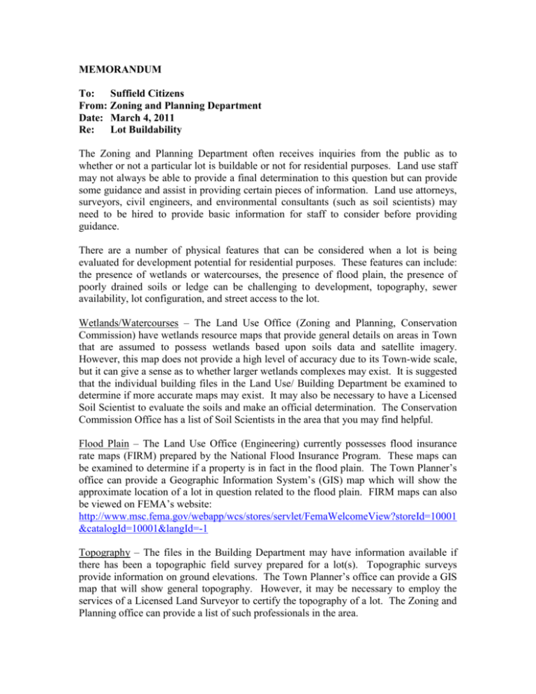
MEMORANDUM To: Suffield Citizens From: Zoning and Planning Department Date: March 4, 2011 Re: Lot Buildability The Zoning and Planning Department often receives inquiries from the public as to whether or not a particular lot is buildable or not for residential purposes. Land use staff may not always be able to provide a final determination to this question but can provide some guidance and assist in providing certain pieces of information. Land use attorneys, surveyors, civil engineers, and environmental consultants (such as soil scientists) may need to be hired to provide basic information for staff to consider before providing guidance. There are a number of physical features that can be considered when a lot is being evaluated for development potential for residential purposes. These features can include: the presence of wetlands or watercourses, the presence of flood plain, the presence of poorly drained soils or ledge can be challenging to development, topography, sewer availability, lot configuration, and street access to the lot. Wetlands/Watercourses – The Land Use Office (Zoning and Planning, Conservation Commission) have wetlands resource maps that provide general details on areas in Town that are assumed to possess wetlands based upon soils data and satellite imagery. However, this map does not provide a high level of accuracy due to its Town-wide scale, but it can give a sense as to whether larger wetlands complexes may exist. It is suggested that the individual building files in the Land Use/ Building Department be examined to determine if more accurate maps may exist. It may also be necessary to have a Licensed Soil Scientist to evaluate the soils and make an official determination. The Conservation Commission Office has a list of Soil Scientists in the area that you may find helpful. Flood Plain – The Land Use Office (Engineering) currently possesses flood insurance rate maps (FIRM) prepared by the National Flood Insurance Program. These maps can be examined to determine if a property is in fact in the flood plain. The Town Planner’s office can provide a Geographic Information System’s (GIS) map which will show the approximate location of a lot in question related to the flood plain. FIRM maps can also be viewed on FEMA’s website: http://www.msc.fema.gov/webapp/wcs/stores/servlet/FemaWelcomeView?storeId=10001 &catalogId=10001&langId=-1 Topography – The files in the Building Department may have information available if there has been a topographic field survey prepared for a lot(s). Topographic surveys provide information on ground elevations. The Town Planner’s office can provide a GIS map that will show general topography. However, it may be necessary to employ the services of a Licensed Land Surveyor to certify the topography of a lot. The Zoning and Planning office can provide a list of such professionals in the area. Sewer Availability – The Land Use office can provide general information on the location of sewer lines in Suffield. However, the Water Pollution Control Authority (WPCA) should be consulted to determine whether a lot has the ability to connect to the municipal sewer lines. For more information contact the WPCA at (860) 668-3853. If the municipal sewers are not available for the lot in question the North Central District Health Department (NCDH) will need to be consulted. The NCDH gives approval for septic systems and drinking water wells. You can contact the NCDH at; 31 North Main Street P.O. Box 1222 Enfield, Ct 06083-1222 Phone – (860) 745-0383 Lot Configuration/Street Access – The Building Department may have information to determine if there has been boundary survey conducted on the lot in question. A survey or site plan may exist in these files. It may be necessary to have a Licensed Land Surveyor to certify the boundary of a lot. Also, it may be necessary to employ the services of an Attorney or Title Searcher to analyze the land records to make determinations on property ownership, easements and conveyances. If you have a desire to continue to own a particular lot or a part of a lot and do not wish to have it considered a buildable lot you can dedicate the lot for conservation purposes. A conservation easement allows a property owner to continue to own, maintain and enjoy the use of a lot but the lot is preserved as open space and cannot be developed. This can cause the value of the lot to be reduced due to its limited development potential. The Town Planner can provide guidance on how to pursue this option. For information on lots of record see Section III.B. of the Suffield Zoning Regulations. The regulations are available at the Zoning and Planning Department for a fee or free online at: http://www.suffieldtownhall.com/filestorage/2951/163/1715/Regs_Effective_6-42010.pdf If there are any questions pertaining to this memorandum or how the Land Use Office can be of further assistance, please contact Bill Hawkins, AICP, Town Planner at (860) 668-3848 or bhawkins@suffieldtownhall.com
