Major small dams in district Chakwal
advertisement
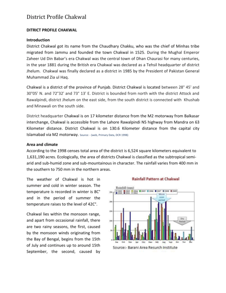
District Profile Chakwal DITRICT PROFILE CHAKWAL Introduction District Chakwal got its name from the Chaudhary Chakku, who was the chief of Minhas tribe migrated from Jammu and founded the town Chakwal in 1525. During the Mughal Emperor Zaheer Ud Din Babar’s era Chakwal was the central town of Dhan Chaurasi for many centuries, in the year 1881 during the British era Chakwal was declared as a Tehsil headquarter of district Jhelum. Chakwal was finally declared as a district in 1985 by the President of Pakistan General Muhammad Zia ul Haq. Chakwal is a district of the province of Punjab. District Chakwal is located between 28° 45' and 30°05' N. and 72°32' and 73° 13' E. District is bounded from north with the district Attock and Rawalpindi, district Jhelum on the east side, from the south district is connected with Khushab and Minawali on the south side. District headquarter Chakwal is on 17 kilometer distance from the M2 motorway from Balkasar interchange, Chakwal is accessible from the Lahore Rawalpindi N5 highway from Mandra on 63 Kilometer distance. District Chakwal is on 130.6 Kilometer distance from the capital city Islamabad via M2 motorway. Source: - (web, Primary Data, DCR 1998) Area and climate According to the 1998 censes total area of the district is 6,524 square kilometers equivalent to 1,631,190 acres. Ecologically, the area of districts Chakwal is classified as the subtropical semiarid and sub-humid zone and sub-mountainous in character. The rainfall varies from 400 mm in the southern to 750 mm in the northern areas. The weather of Chakwal is hot in summer and cold in winter season. The temperature is recorded in winter is 8C° and in the period of summer the temperature raises to the level of 42C°. Chakwal lies within the monsoon range, and apart from occasional rainfall, there are two rainy seasons, the first, caused by the monsoon winds originating from the Bay of Bengal, begins from the 15th of July and continues up to around 15th September, the second, caused by District Profile Chakwal Mediterranean winds lies in the last two weeks of December and the first two weeks of January. Source: - BARI, DCR 1998 Topography Geographically place in the salt range and Pothowar plateau, the physical features of Chakwal are typical of the region. The south and south east is mountainous and rocky, covered with scrub forest, interspaced with flat lying plains; the north and the north east consist of softly undulating plains area with patches of rocky area, known as khuddar in the local dialect, ravines and gorges and some desert areas. The plains of the district are being cultivated, even those which lie in hilly regions and a considerable are is covered by forests. Geology The area of Chakwal can be classified into mountains, hills, rocks, plains, weather-rocked plains, piedmont plains and river plains. The soil of the area has developed from wind and water transported material consisting of loess alluvial deposits, mountain outwash and recent streamvalley deposits. A part of the soil has also been derived from shale and sand stones. The rangelands in district are severely depleted due to soil erosion, which is a widespread problem. Rainwater readily runs off in the streams soon after downpours. The southern portion runs up into the Salt Range, and includes the Chail peak, 3,701 feet (1,128 m) above the sea, the highest point in the district between this and the Sohan river, which follows more or less the northern boundary. Source: - DCR 1998 Population: Population of the district is estimated 1,351,000 in 2013 which gives population density of 205 persons per square kilometers. The total population of the district was 1,083,725 in 1998 with the density of 166 persons per square kilometer. According to 1998 censes the urban population was 12.2% of the total population and District Profile Chakwal 87.8% population was rural population. In year 2013 it is estimated that urban population is 14% and rural population is 86%. As per 1998 censes the male population of the district was 52% and female population was 48% of the total population. 44% population is estimated blow the age of 15 years. The litracey ratio in district Chakwal has increased from 39.7% in 1981 to 56.7% in 1998. The litracey ratio for males in 73.4% as against 42.2% for female. The ratio is much higher in urban when compared with rural area both for male and female. (Source:- Punjab Development Statistiics 2013, DCR 1998.) Area All Area Rural Urban Both Sexes 56.7% 54.8% 70.7% 1998 Male 73.4% 72.5% 79.3% Female 42.2% 39.6% 61.8% Punjabi (Potohari) is the pre dominate language being spoken in the district representing 97.7% of the population followed by Pushto spoken by 1.2%, Urdu 0.9% and Siraiki 0.2% while other speaks Sindhi, Balochi, Bravi, Dari etc. 80% of the population living in Chakwal District is ethnically Punjabis of Aryan origin. The remaining 20 % are Jatts, Khokhars, Jatt Bhuttas, Awans, Mair Minhas, Kahuts, Janjuas, Mughal Kassars, Gujjars, Syeds, Gondals, Sheikhs, and Awans. Economy Agriculture is the main activity of the district Chakwal. Farming and farm related activities are the main occupation of the district. Livestock is kept on large scale. Chakwal is the most recruiting area of the armed forces there is huge number of peoples serving in armed forces from Chakwal. The first Indian to get commissioned and become a General in British Indian army (General Muhammad Akbar Khan) was from Chakwal. There are considerable deposits of minerals are mined in district Chakwal especially coal reserves in area of Chao Syden Shah. There are about 246 number of coal mines exists in Chakwal. There are also reserves of lime stones and marble are extracted from the Chakwal. There are 4 number of cement factories are established in district Chakwal. People also employed in mining and cement industry. People of Chakwal also related to businesses. Small number of peoples related to health, education, banking etc. S .NO 1 2 3 INDUSTRY Agricultural Implements Cement Ceramics Products NO. OF UNITS INSTALLED CAPACITY 4 3 1 3400 Nos. 5700 Th. M.Tons 30000 Nos. District Profile Chakwal 4 5 6 7 8 9 10 Cold Storage Flour Mills Paper Cone Poultry Feed Textile Spinning Textile Weaving (Mill Sector) Tobacco 2 5 1 1 6 1 1 115000 Bags 720 M.Tons/ Day 1400000 Nos. 97500 M.Tons 184136 Spindles 100 Looms 47250 Th. Nos. Source: - Pre Investment Study Chakwal 2009 Chakwal has recently bestowed with Kanaish phone and trade (PVT) limited, Chakwal first Payphone Company authorized by Pakistan telecommunication authority. Chakwal is also famous for pehlwan Rewary. Bestway cement installed the largest unit of Asia in Chakwal. Provincial government is planning to install coal power plant in Tehsil Choa Syedn Shah. There are about 138 different factories established in district which provides the employment to estimated 10805 people. The various minerals which exist and are being mined at different places are Argillaceous Clay, Antimony, Copper, Gold, Gemstone, Lime Stone, Dolomite,Bentonite, Fireclay, Marble, Rock Salt, Coal, Crude Oil and Natural Gas, Brine, Salica Sand. All these minerals, with the exceoption of Gold, Copper and Gemstones are being successfully mined. The miining of Gold, Copper and Gemstones is not fesibible owingto their small deposits and heavey cost required for extraction. Production of S.No 1 2 3 4 5 6 7 8 9 10 11 12 13 the major minarls for the year 2011-12 is given in table below Minerals Production ( Hundrad Matric Tons) Argillaceous Clay 21030 Bauxite 60 Bentonite 32 Coal 2914 Dolomite 64 Fireclay 41 Gypsum 1537 Iron Ora 266 Latrit 156 Lime Stone 73223 Marble 2 Ochers 7 Rock Salt 6034 Source:- Directorate General, Mines and Minerals , Punjab, Lahore ( Punjab Development Statistcis 2013, Beareu of Statistics , Governemet of the Punjab Lahore Pakistan.) District Profile Chakwal Cement Industry Choa Syden Shah Demographic data District Chakwal is consisting of 5 Tehsils and 72 union councils. There are 8 urban and 64 rural union councils in the district. Lawa is notified as a fifth Tehsil of Chakwal in 2013. (Detail of Tehsil and union councils) Tehsils Number of Union Councils Urban Rural Population (Thousand Persons) Total As Per 1998 Censes Rural Urban 1998 Urban Population % Estimated on 31-12-2013 Total Rural Urban Total Chakwal 5 27 32 410 80 490 511 100 611 13.% Talagang 2 18 20 268 38 306 335 47 382 13.2% Kalar Kahar - 8 8 108 - 108 134 - 134 - Choa Syden Shah Lawa 1 5 6 92 14 106 115 17 132 13.2% - 6 6 74 - 74 92 - 92 - 64 72 952 132 1084 1187 164 1351 12.2% Total 8 Source: - Delimitation notification 23-12-2013, Punjab development statistics 2013. Natural Resources and land use Agriculture: Agriculture is the main activity of the district around 80% of the total population of the district is related to the agriculture. The main crops grown in district are Wheat, Groundnut, Oilseeds, Grams, Lentils- Masoor, Moong, Mash, Maize, Millets, Jawar. Mainly the District Profile Chakwal whole district is rain fed and yield is dependent on rain. As per Punjab development statistics 2013 the net sown area of the district was 652,176 and 578,226 acres area was rainfed only 46,950 acre area was irrigated. According to the statistics by the government of Punjab there are 5704 tube wells installed in district. According to agriculture censes 2000, 12% HHs have less the 1 acre land, 28% HHs have 1 to 2.5 acers,25% HHs have 2.5 to 5 acres,16% HHs have 5 to 7.5 acre,11% HHs have 7.5 to 12.5 acres,6% HHs have 12.5 to 25 acres, 1% HHs have 25 to 50 acres,302 HHs have 50 to 100 acres,379 HHs have 100 to 150 acres and 18 HHs have 150 and above acres.83% farmers are self operators, 8% are owners cum farmers and 9% area is operated by the tenet farmers. Groundnut and wheat are the major crops cultivated on the large scale. There are some areas in district where the ownership of the lands is rest with the land lord families but generally the people living in the district are the owners of their lands. There is tenet farmers exist in the district in very limited numbers. Normally tenet farmers get 2/3 of the crop and land lords’ gets 1/3 portion. There is a trend of lease of land on amount of 7000 to 1000 rupees per acre. Fruit orchards, especially of citrus, have been planted but only small area owing because of the shortage of water. Fair size of loquat orchards established in Tehsil Kallar Kahar and Choa Saidan Shah. Besides Apricot, Banana, Pears, Peaches and Pomegranate are also grown in minor quantities in the district. Farming is done with the conventional methods; Barani Area Agriculture Institute introduced new techniques and methods in the district. District Profile Chakwal (Land utilization statistics) Reported Area Cultivated Area (Thousand Hectares) 668 (1650663 Acres) Total 318 (785795 Acres 47.60%) Net Sown 242 (597995 Acres 36.22%) Current Fallow 76 (187800 Acres 11.3) Source:-Bureau of Statistics, Punjab, Lahore Turnip, Cauliflower, Tomato, Lady Finger, Onion and Carrot are main vegetables grown in the district. A large number of rose gardens have been planted by the farmers in Kallar Kahar area and the quality of roses produced at this place is probably better then the roses produced at any other place in the country. The roses are of desi (local) variety and are used primarily for the distillation of rose water and preparation of Gulqand (a mix of rose petals juice and sugar). Agriculture activities in the district are looked after by the Department of Agriculture, Government of Punjab. Source: - District Government Chakwal District Profile Chakwal Water Resources Water resources are not adequate in district especially for irrigation purpose only 8 % area gets water for the irrigation purpose. According to the local communities the underground water level is 130 to 300 feet. About 83% of the population of district has drinking water available. Chakwal is rain fed district and there is no irrigation system in Chakwal. There are natural springs in Tehsil Choa Syden Shah but the water level is reducing in these springs with Mini Dam Dhurnal UC Tehsil Lawa the establishment of cement factories in the area. There is also a natural lake in Kallar Kahar area but the water of the lake is not used for any purpose because of the mountainous nature of the area. There is no river passes through Chakwal district except Soan. The Soan river enter Chakwal District from the Pindi Gheb area, passes through Hasli- Warwal into Talagang sub division, flow across Tamman and finally falls into the Indus on the boarder of Mianwali- Kohat Districts. During the summer and rainy season there is heavy flow of water in the river, but in winter it takes the shape of a rivulet. A number of nullahas cross through Chakwal District. The more important of which is a Nullah Soj, Wahan, Ghabbir, Tarapi, Dharabi and Banhaa. The only lake that exists in Chakwal district is the very well known lake of Kallar Kahar which is fed by the surrounding mountain streams. Only 8% area is irrigated, 1.5% through Canals, 3.5% wells, 2% Tube wells, 0.5% Canal wells and 0.5% through canal Tube wells. There are 3582 diesel tube wells are installed in district Chakwal 3581 tube wells belongs to the private persons and 1 numbers of diesel tube wells is government, there is 2122 electric tube wells are installed in district, 2121 are private and 1 is government. The total number of tube wells in district Chakwal is 5704, the 5702 number of tube wells is private and 27 are government. There are 65 mini dams constructed by the soil conservation department in the district to store the rain water the main purpose of these dams seems to lift the ground water level up. Majority numbers of these small dams are not used for irrigation purposes. There are 12 numbers of small dams constructed by the power and irrigation department in the district with the objective of irrigation, livestock uses, development of Fish culture etc. (Major small dams in district Chakwal) District Profile Chakwal Location of dams Name of dams Number of small dams Storage Capacity Area Benefiting Under Construction Dhok Sial Dam (Balkasar), Munday Dam, Kot Sarang Dam, Mishran Wala Kund Dam, Nikki Dam (Hajial), Nukko Dam (Padshahan), Dhoke Hum (Chokandi) Dhok Sial Dam (Balkasar), Munday Dam, Kot Sarang Dam, MishranWalaKund Dam, Nikki Dam (Hajial), Nukko Dam (Padshahan), Dhok Hum (Chokandi) 12 26,411 in acres feet 11,089 acres 4 (Dharabi , Khai, Minwal & Gavial) Source: - District Government Chakwal Forest Considerably large area of Chakwal district are covered by forests, most of these forests exists naturally and some planted by the forest department. The forests which exist naturally, since Chakwal lies in the subtropical, semiarid zone, are dry deciduous scrub, consisting of the plant varieties which are typical of these kinds of forests- keeker, kau, phulai, sanatha, wild beri, gurgura and potaki. The under bush mainly consists of saryala, khawi, mesquite and karir. In the plantations that have been carried out by the Forest Department and private farmers, apart Markhal (UC Budhial) from the naturally occurring species of trees, the sheesham, sufaida and to some extent the poplar trees have also been planted. The Chakwal forest division is spread over an area of 242254 acres which is 14.85% of the total area of district. At present a total of 193560 acres of the district are under reserve forest and 48694 acres are under unclassified forest. The main reserve and unclassified forests in the district are at Diljabbah, Surullah, Drangan, Karangal, Gandala, Dalwal, Makhiala, Dandot, Chinji, Kot Kala, Simbli, Nurpur, Bagga, Sammarqand and Thirchak. Forests in Chakwal district are taken care of by the Chakwal Forest Division, headed by the Divisional Forest Officer who is assisted by four Sub-divisional Forest Officers. District Profile Chakwal (Forest covered area) Total Compact (Hectares) 98037 (242254 acres) Total Linear ( Running Kilometer ) 415 Reserve Forests (Hectares) 78331 (193560 acres) Unclassified Forests (Hectares) 19706 (48694 acres) Source: - Government of Punjab, 2013. Punjab Development Statistics 2013, Bureau of Statistics, Government of Punjab, Lahore. ( Forestry, Wildlife, Fisheries and Tourism Department, Government of the Punjab, Lahore.) Livestock A huge number of populations of district Chakwal keep livestock at house hold level. However a number of poultry and dairy farms have been established in the private sector, which utilize modern technology of breeding and raring are commercially oriented. The hilly prairies and grazing lands provides sufficient fodder for the livestock. Animals are taken to pastures on daily basis for Livestock grazing UC Bharpur grazing. Livestock is kept for meat; milk, butter, yogurt or as an assets. The majority of the farmers maintain their own Sheep Goat herds and cattle. The “Beetal” breed goat is kept on large scale in Talagang area came from Rajan Pur. Goats and Sheep’s are kept for the whole year and sold on the event of Eid Ul Adha. Milk is collected from the different villages on the payment of 50 rupees per liter Buffalo milk and 45 rupees paid for the cow milk to the livestock keepers by the milk collectors. Milk is sold domestically and carried to the main cities of the district Chakwal, Rawalpindi and Islamabad. (Population of livestock in district Chakwal) Cattle 435,000 Buffalos Camels 145,000 1183 Bullocks Sheep’s Goats Horses Asses Mules 1342 158,000 580,000 1860 37624 1035 Source:-census of livestock 2006 Poultry farming is also done on large scale in the Chakwal district. Baylor, Layer and Breeding poultry farms are established in throughout the district. (Poultry Farms in Chakwal district) Capacity to rare birds ( Per Annum) Broiler in thousands Layer 1519 34510 184 Source: - MICS 2011-12 Capacity to rare birds in thousands 980 Breeding 20 Capacity to rare birds in thousands 290 District Profile Chakwal For the treatment of the livestock there are 14 veterinary hospitals 66 veterinary dispensaries and 21 veterinary centers are established by the Livestock department in district Chakwal. Roads and Communication Distract Chakwal is connected with the network of black toped roads within the district and adjacent areas. The total length of the metal roads is 2610.6 kilometers. M2 Lahore Islamabad motorway passes within the district. The length of the motorway is 79 kilometers within the district. From motorway district is accessible through Balkasar and Kallar Kahar interchange. The length of the provincial highways within the district is 414.93 kilometers, R & B sector roads length is 91.88 Kilometers. The length of farm to market roads is 1432.18 kilometers and district council’s roads length is 592.61 kilometers. There are not rail connections and any kind of airport established within the district Chakwal. The facilities of mobile, telephone, internet and postal services are available in district Chakwal. Public transport runs to all the major cities of the country from the main cities of Chakwal district. People normally use quiqui Rickshaws for travelling with in the cities. Disasters There is a visible changes coming in the climate which is affecting the human life and natural resources. Significant change in the rain patterns causing flash floods and sometime droughts. District Chakwal is not venerable to heavy floods but occasional heavy rains causing flash floods. District Chakwal is considered as a no flood area of the providence. Drought is a slow on set phenomenon that affects various sectors in the vulnerable areas. They affect large geographic areas than floods or other hazards. Rainfall variation during different seasons is also considerably high. District Profile Chakwal Low rainfall and precipitation resulted in the lowest water levels recorded in Pakistan. In the year 2000 the rainfall was 14 percent lower than that in 1999, following on from declines of 13.2 percent and 26.2 percent in 1999 and 1998 respectively. 21% of Punjab province's economy was affected by the drought of 1998-2002. According to the Meteorological Department, the district Chakwal is prone district to drought hazard. The growing industries especially in cement factories established in Choa Syden Shah are hazard. Tehsil Choa Syden Shah is known from its natural springs according to the local community with the establishment of industries the level of water in springs is decreased. Source:-Disaster Risk Management Plan Punjab 2008 According to geological survey of Pakistan district Chakwal falls away from the fault line and is unlikely to be affected from massive earthquake. Major NGOs There are 122 registered NGOs in district Chakwal but only a few international, national and local NGOs are active in district Chakwal and providing valuable services to communities in different sectors, including education, health and environment. Most of the local NGOs are either dormant and or don’t have the capacity and resources to play their role affectively. S# Major Working Area Address 1 Organization Name NRSP Micro Finance/ Credit All District 2 IRADAH Chakwal 3 DHEWA Bheen Chak Malook Dub Dhodial Village Bheen Tehsil and District Chakwal 0543862295 03005476950 ( Amjad) 4 Qazi Foundation Rehabilitation centre for the physical disabled. School for deft children’s Vocational centre for women Training centre for disabled Hostel for helpless disables Youth Awareness raising Education Health Child protection Agriculture Education funds QarzeHasna Medical related Help Thanil Chowk Rawalndi bypass Mohallah Sadique Abad Street No.6, Chakwal Buchal Kallan District Chakwal 0573586630 izharawan@hotmail.com www.iradah.org Tehsil Chakwal 03150104939 (Maj Naheem Asghar) www.qazifoundation.org District Profile Chakwal 5 PRSP 6 VOICH 7 Plan Pakistan Support to poor Community Health sessions Community Mobilization All District Mr. Pervaiz Akhtar District Support Manager, Chakwal District Health Development Center, Chakwal 0543-660040 0543-660040 0342-9412521 www.prsp.org.pk dsm_chk@yahoo.com Health Education Tehsil Chakwal Heath Bhar Pur, Munday, Bhagwal, Mangwal, Begal, Dullah, Choa Ganj Ali Shah, Chak Umra, Siral, Kot Chodri, Sagal Abad, Kahir Pur, Mullah Mughlan, Kallar Kahar, Chak Malook, Basharat, Karsal, Lehar, Munra, Balokasar, Warwal. Health Care Centre Rawalpindi Road Chakwal 0543554688 03315980055 Plan International –Pakistan Programme Unit Chakwal MCB 3/401 Mohallah Shumali Behkri road Chakwal www.plan-international.org 0543550222-295 0543550221 Education Livelihood child and gender rights disaster risk reduction and response District Government At the district level three-tier government system has been put in place, consisting on district government, Tehsil municipal administration (TMA) and union council administration. The district is headed by the deputy commissioner supervises and coordinates the functioning of all the provincial departments in the district. The office of the deputy commissioner is established in district complex. Forest, Soil conservation, Community development and small dams have also their offices in district complex Chakwal. Agriculture, livestock and water management department have their offices in the main city near rescue 1122 District Profile Chakwal District Government Departments Department District Administration District Administration Finance and Planning Finance Planning and Development Health Department Education Department Works and Services Department Agriculture Department Agriculture Livestock Soil Conservation Fisheries Agriculture Extension Water Management Barani Area Research Institute Community Development Information Department Tehsil Municipal Administration Public Health Engineering Small Dams Small Industries Department Election Commission Forest Department Local Government Mines and Mineral Department Population Office Public Safety Commission Head of the Office Deputy Commissioner/DCO AC Chakwal EDO (F & P) DO (B & F) DO Planning EDO (Health) EDO (Education) EDO (W & S) EDO (Agriculture) DO (Agri Ext) DO (Livestock) DO ( Soil Conservation) DO (Fisheries) DDO (Agri Ext) DO (Water Management) Director (BARI) EDO (CD) District Information Officer Administrator TMA XEN Public Health Engineering XEN Small Dams Assistant Director Assistant Election Commissioner Divisional Forest Officer Assistant Director Local Government Deputy Director Mines DO Population Chairman Contact No 0543660001 0543553220 0543660105 0543660223 0543660008 0543660163 0543660120 0543660078 0543554543 0543551556 0543550865 0543660122 0543550617 0543553438 0543554764 0543594501 0543660121 0543660093 0543550682 0543552901 0543660123 0543553158 0543550881 0543444777 0543542157 0543660019 0543553353 0543550728 District Profile Chakwal Rain water Harvesting District Chakwal is the rain fed distract and agriculture is mainly relaying on the rain. There are serial affords has been made to retain the rain water and to utilize for irrigation purpose. Small dams, drip irrigation, sprinkle irrigation and roof harvesting technologies are introduced by the different departments and organizations. geographically Tehsil Chakwal consists on plain areas, Tehsil Kallar Kahar and Choa Syden Shah are mostly mountainous and Tehsil Talagang and newly notified Tehsil Lawa are semi mountainous having plains and hilly areas. Different technologies of rain harvesting are used almost in the all parts of the district. There is a lot of potential observed for the rain harvesting in the Tehsil Talagang and Lawa. There is a project “Drought Mitigation and Preparedness “is launched in union council Lawa by PPAF through NRSP. There are 28 number of rain harvesting ponds,8 number of mini dams, 33 number of irrigation schemes and 6 number of rain water retaining structures are established in the union council Lawa by NRSP. There are some efforts like mini dams, lift irrigation system; Dug well and submersible pumps are initiated by the government departments. There is no major initiatives has been taken in the area except union council Lawa. The potential for the rainwater harvesting is high in Tehsil Talagang and Lawa as the area is semi mountainous and plains and the main source of income is agriculture and livestock. There are a large number of small basins/ catchments, where rain water harvesting techniques can be applied by considering the amount of runoff generated. The farmers, who are suffering shortage of irrigation water and could not grow their crops due to less availability of irrigation water, will be able to perform agriculture practice through rainwater harvesting.


