Appendix 1
advertisement
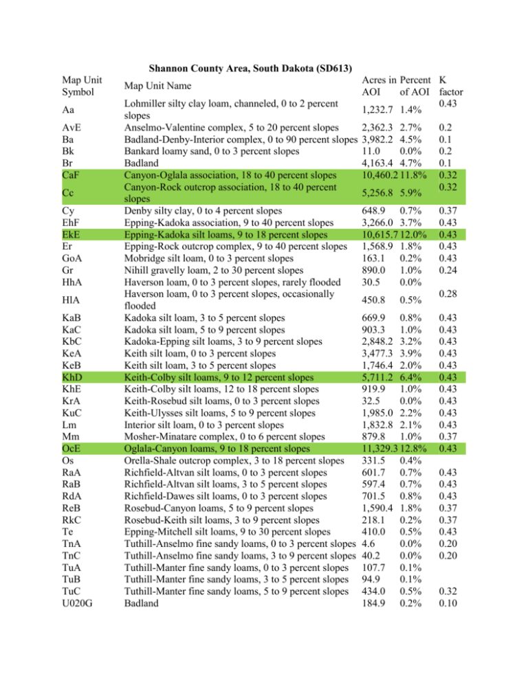
Shannon County Area, South Dakota (SD613) Map Unit Symbol Aa AvE Ba Bk Br CaF Cc Cy EhF EkE Er GoA Gr HhA HlA KaB KaC KbC KeA KeB KhD KhE KrA KuC Lm Mm OcE Os RaA RaB RdA ReB RkC Te TnA TnC TuA TuB TuC U020G Map Unit Name Lohmiller silty clay loam, channeled, 0 to 2 percent slopes Anselmo-Valentine complex, 5 to 20 percent slopes Badland-Denby-Interior complex, 0 to 90 percent slopes Bankard loamy sand, 0 to 3 percent slopes Badland Canyon-Oglala association, 18 to 40 percent slopes Canyon-Rock outcrop association, 18 to 40 percent slopes Denby silty clay, 0 to 4 percent slopes Epping-Kadoka association, 9 to 40 percent slopes Epping-Kadoka silt loams, 9 to 18 percent slopes Epping-Rock outcrop complex, 9 to 40 percent slopes Mobridge silt loam, 0 to 3 percent slopes Nihill gravelly loam, 2 to 30 percent slopes Haverson loam, 0 to 3 percent slopes, rarely flooded Haverson loam, 0 to 3 percent slopes, occasionally flooded Kadoka silt loam, 3 to 5 percent slopes Kadoka silt loam, 5 to 9 percent slopes Kadoka-Epping silt loams, 3 to 9 percent slopes Keith silt loam, 0 to 3 percent slopes Keith silt loam, 3 to 5 percent slopes Keith-Colby silt loams, 9 to 12 percent slopes Keith-Colby silt loams, 12 to 18 percent slopes Keith-Rosebud silt loams, 0 to 3 percent slopes Keith-Ulysses silt loams, 5 to 9 percent slopes Interior silt loam, 0 to 3 percent slopes Mosher-Minatare complex, 0 to 6 percent slopes Oglala-Canyon loams, 9 to 18 percent slopes Orella-Shale outcrop complex, 3 to 18 percent slopes Richfield-Altvan silt loams, 0 to 3 percent slopes Richfield-Altvan silt loams, 3 to 5 percent slopes Richfield-Dawes silt loams, 0 to 3 percent slopes Rosebud-Canyon loams, 5 to 9 percent slopes Rosebud-Keith silt loams, 3 to 9 percent slopes Epping-Mitchell silt loams, 9 to 30 percent slopes Tuthill-Anselmo fine sandy loams, 0 to 3 percent slopes Tuthill-Anselmo fine sandy loams, 3 to 9 percent slopes Tuthill-Manter fine sandy loams, 0 to 3 percent slopes Tuthill-Manter fine sandy loams, 3 to 5 percent slopes Tuthill-Manter fine sandy loams, 5 to 9 percent slopes Badland Acres in Percent K AOI of AOI factor 0.43 1,232.7 1.4% 2,362.3 2.7% 3,982.2 4.5% 11.0 0.0% 4,163.4 4.7% 10,460.2 11.8% 5,256.8 5.9% 648.9 0.7% 3,266.0 3.7% 10,615.7 12.0% 1,568.9 1.8% 163.1 0.2% 890.0 1.0% 30.5 0.0% 450.8 0.5% 669.9 0.8% 903.3 1.0% 2,848.2 3.2% 3,477.3 3.9% 1,746.4 2.0% 5,711.2 6.4% 919.9 1.0% 32.5 0.0% 1,985.0 2.2% 1,832.8 2.1% 879.8 1.0% 11,329.3 12.8% 331.5 0.4% 601.7 0.7% 597.4 0.7% 701.5 0.8% 1,590.4 1.8% 218.1 0.2% 410.0 0.5% 4.6 0.0% 40.2 0.0% 107.7 0.1% 94.9 0.1% 434.0 0.5% 184.9 0.2% 0.2 0.1 0.2 0.1 0.32 0.32 0.37 0.43 0.43 0.43 0.43 0.24 0.28 0.43 0.43 0.43 0.43 0.43 0.43 0.43 0.43 0.43 0.43 0.37 0.43 0.43 0.43 0.43 0.37 0.37 0.43 0.20 0.20 0.32 0.10 Shannon County Area, South Dakota (SD613) Map Unit Symbol U110A U110B U192G U215F U325B U360F U545E Vs W Ww Map Unit Name Cedarpass silt loam, 0 to 3 percent Cedarpass silt loam, 3 to 6 percent slopes Epping-Keota-Badland complex, moist, 9 to 50 percent slopes Epping, moist-Badland complex, 9 to 40 percent slopes Interior loam, channeled, 0 to 6 percent slopes, flooded Keota, thick surface-Epping-Badland complex, moist, 9 to 40 percent slopes Oglala-Canyon, moist loams, 9 to 25 percent Valentine sand, 3 to 30 percent slopes Water Wortman-Wanblee silt loams, 0 to 6 percent slopes Shannon County Area, South Dakota CaF—Canyon-Oglala association, 18 to 40 percent slopes Map Unit Setting Elevation: 2,950 to 3,940 feet Mean annual precipitation: 13 to 19 inches Mean annual air temperature: 43 to 50 degrees F Frost-free period: 135 to 145 days Map Unit Composition Canyon and similar soils: 50 percent Oglala and similar soils: 30 percent Minor components: 20 percent Description of Canyon Setting Landform: Ridges Landform position (two-dimensional): Summit, shoulder Down-slope shape: Convex Across-slope shape: Convex Parent material: Residuum weathered from calcareous sandstone Acres in AOI 4.5 25.5 940.0 Percent K of AOI factor 0.0% 0.0% 0.43 1.1% 2.5 0.0% 3,646.0 4.1% 39.3 0.0% 56.5 737.8 65.6 349.2 0.1% 0.8% 0.1% 0.4% 0.43 0.15 0.37 Properties and qualities Slope: 18 to 40 percent Depth to restrictive feature: 6 to 20 inches to paralithic bedrock Drainage class: Well drained Capacity of the most limiting layer to transmit water (Ksat): Moderately high (0.20 to 0.57 in/hr) Depth to water table: More than 80 inches Frequency of flooding: None Frequency of ponding: None Calcium carbonate, maximum content: 10 percent Maximum salinity: Nonsaline (0.0 to 2.0 mmhos/cm) Available water capacity: Very low (about 1.8 inches) Interpretive groups Farmland classification: Not prime farmland Land capability (nonirrigated): 7e Hydrologic Soil Group: D Ecological site: Shallow (R064XY040NE) Other vegetative classification: Not suited (G064XY000NE) Typical profile 0 to 4 inches: Loam 4 to 10 inches: Loam 10 to 60 inches: Weathered bedrock Description of Oglala Setting Landform: Hills Landform position (two-dimensional): Backslope Down-slope shape: Linear Across-slope shape: Linear Parent material: Residuum weathered from sandstone Properties and qualities Slope: 18 to 40 percent Depth to restrictive feature: 40 to 60 inches to paralithic bedrock Drainage class: Well drained Capacity of the most limiting layer to transmit water (Ksat): Moderately low to high (0.06 to 1.98 in/hr) Depth to water table: More than 80 inches Frequency of flooding: None Frequency of ponding: None Calcium carbonate, maximum content: 10 percent Maximum salinity: Nonsaline (0.0 to 2.0 mmhos/cm) Available water capacity: Moderate (about 8.7 inches) Interpretive groups Farmland classification: Not prime farmland Land capability (nonirrigated): 6e Hydrologic Soil Group: B Ecological site: Loamy 17-20 P.Z. (R064XY036NE) Other vegetative classification: Not suited (G064XY000NE) Typical profile 0 to 7 inches: Loam 7 to 48 inches: Very fine sandy loam 48 to 60 inches: Weathered bedrock Minor Components Rosebud Percent of map unit: 11 percent Landform: Hills Landform position (two-dimensional): Backslope Down-slope shape: Linear Across-slope shape: Linear Ecological site: Loamy 17-20 P.Z. (R064XY036NE) Other vegetative classification: Loam (G064XY100NE) Rock outcrop Percent of map unit: 4 percent Ecological site: Non-site (R064XY999NE) Other vegetative classification: Not suited (G064XY000NE) Ulysses Percent of map unit: 2 percent Landform: Hills Landform position (two-dimensional): Backslope Down-slope shape: Linear Across-slope shape: Linear Ecological site: Loamy 17-20 P.Z. (R064XY036NE) Other vegetative classification: Loam (G064XY100NE) Colby Percent of map unit: 2 percent Landform: Ridges Landform position (two-dimensional): Summit, shoulder Down-slope shape: Convex Across-slope shape: Convex Ecological site: Thin Upland (R064XY037NE) Other vegetative classification: Not suited (G064XY000NE) Mobridge Percent of map unit: 1 percent Landform: Drainageways Landform position (two-dimensional): Footslope Down-slope shape: Concave Across-slope shape: Linear Ecological site: Loamy 17-20 P.Z. (R064XY036NE) Other vegetative classification: Loam (G064XY100NE) Shannon County Area, South Dakota Cc—Canyon-Rock outcrop association, 18 to 40 percent slopes Map Unit Setting Elevation: 2,950 to 3,940 feet Mean annual precipitation: 13 to 19 inches Mean annual air temperature: 43 to 50 degrees F Frost-free period: 135 to 145 days Map Unit Composition Canyon and similar soils: 45 percent Rock outcrop, sandstone: 25 percent Minor components: 30 percent Description of Canyon Setting Landform: Ridges Landform position (two-dimensional): Shoulder, summit Down-slope shape: Convex Across-slope shape: Convex Parent material: Residuum weathered from calcareous sandstone Properties and qualities Slope: 18 to 40 percent Depth to restrictive feature: 6 to 20 inches to paralithic bedrock Drainage class: Well drained Capacity of the most limiting layer to transmit water (Ksat): Moderately high (0.20 to 0.57 in/hr) Depth to water table: More than 80 inches Frequency of flooding: None Frequency of ponding: None Calcium carbonate, maximum content: 10 percent Maximum salinity: Nonsaline (0.0 to 2.0 mmhos/cm) Available water capacity: Very low (about 1.8 inches) Interpretive groups Farmland classification: Not prime farmland Land capability (nonirrigated): 7e Hydrologic Soil Group: D Ecological site: Shallow (R064XY040NE) Other vegetative classification: Not suited (G064XY000NE) Typical profile 0 to 4 inches: Loam 4 to 10 inches: Loam 10 to 60 inches: Weathered bedrock Description of Rock Outcrop, Sandstone Properties and qualities Slope: 18 to 40 percent Depth to restrictive feature: 0 to 1 inches to paralithic bedrock Drainage class: Excessively drained Capacity of the most limiting layer to transmit water (Ksat): Moderately high to high (0.20 to 1.98 in/hr) Calcium carbonate, maximum content: 15 percent Gypsum, maximum content: 1 percent Maximum salinity: Nonsaline (0.0 to 2.0 mmhos/cm) Available water capacity: Very low (about 0.0 inches) Interpretive groups Farmland classification: Not prime farmland Land capability (nonirrigated): 8s Hydrologic Soil Group: D Ecological site: Non-site (R064XY999NE) Other vegetative classification: Not suited (G064XY000NE) Typical profile 0 to 60 inches: Weathered bedrock Minor Components Oglala Percent of map unit: 15 percent Landform: Hills Landform position (two-dimensional): Backslope Down-slope shape: Linear Across-slope shape: Linear Ecological site: Loamy 17-20 P.Z. (R064XY036NE) Other vegetative classification: Not suited (G064XY000NE) Mobridge Percent of map unit: 3 percent Landform: Swales Landform position (two-dimensional): Footslope Down-slope shape: Concave Across-slope shape: Linear Ecological site: Loamy 17-20 P.Z. (R064XY036NE) Other vegetative classification: Loam (G064XY100NE) Keith Percent of map unit: 3 percent Landform: Hills Landform position (two-dimensional): Backslope Down-slope shape: Linear Across-slope shape: Linear Ecological site: Loamy 17-20 P.Z. (R064XY036NE) Other vegetative classification: Loam (G064XY100NE) Lohmiller, channeled Percent of map unit: 3 percent Landform: Flood plains Landform position (two-dimensional): Toeslope Down-slope shape: Linear Across-slope shape: Linear Ecological site: Loamy Overflow (R064XY026NE) Other vegetative classification: Overflow (G064XY500NE) Rosebud Percent of map unit: 3 percent Landform: Hills Landform position (two-dimensional): Backslope Down-slope shape: Linear Across-slope shape: Linear Ecological site: Loamy 17-20 P.Z. (R064XY036NE) Other vegetative classification: Loam (G064XY100NE) Colby Percent of map unit: 3 percent Landform: Ridges Landform position (two-dimensional): Summit, shoulder Down-slope shape: Convex Across-slope shape: Convex Ecological site: Thin Upland (R064XY037NE) Other vegetative classification: Not suited (G064XY000NE) Shannon County Area, South Dakota EkE—Epping-Kadoka silt loams, 9 to 18 percent slopes Map Unit Setting Elevation: 2,950 to 3,940 feet Mean annual precipitation: 13 to 19 inches Mean annual air temperature: 43 to 50 degrees F Frost-free period: 135 to 145 days Map Unit Composition Epping and similar soils: 50 percent Kadoka and similar soils: 40 percent Minor components: 10 percent Description of Epping Setting Landform: Hills Landform position (two-dimensional): Shoulder, summit Down-slope shape: Convex Across-slope shape: Convex Parent material: Residuum weathered from siltstone Properties and qualities Slope: 9 to 15 percent Depth to restrictive feature: 10 to 20 inches to paralithic bedrock Drainage class: Well drained Capacity of the most limiting layer to transmit water (Ksat): Moderately low to moderately high (0.06 to 0.20 in/hr) Depth to water table: More than 80 inches Frequency of flooding: None Frequency of ponding: None Calcium carbonate, maximum content: 10 percent Available water capacity: Very low (about 1.2 inches) Interpretive groups Farmland classification: Not prime farmland Land capability (nonirrigated): 6e Hydrologic Soil Group: D Ecological site: Shallow (R064XY040NE) Other vegetative classification: Not suited (G064XY000NE) Typical profile 0 to 2 inches: Silt loam 2 to 6 inches: Silt loam 6 to 60 inches: Weathered bedrock Description of Kadoka Setting Landform: Hills Landform position (two-dimensional): Backslope, summit Down-slope shape: Linear Across-slope shape: Linear Parent material: Residuum weathered from siltstone Properties and qualities Slope: 9 to 15 percent Depth to restrictive feature: 20 to 40 inches to paralithic bedrock Drainage class: Well drained Capacity of the most limiting layer to transmit water (Ksat): Moderately low to moderately high (0.06 to 0.57 in/hr) Depth to water table: More than 80 inches Frequency of flooding: None Frequency of ponding: None Calcium carbonate, maximum content: 15 percent Maximum salinity: Nonsaline (0.0 to 2.0 mmhos/cm) Available water capacity: Low (about 5.6 inches) Interpretive groups Farmland classification: Not prime farmland Land capability (nonirrigated): 4e Hydrologic Soil Group: B Ecological site: Loamy 17-20 P.Z. (R064XY036NE) Other vegetative classification: Loam (G064XY100NE) Typical profile 0 to 3 inches: Silt loam 3 to 8 inches: Silty clay loam 8 to 30 inches: Silt loam 30 to 60 inches: Weathered bedrock Minor Components Keith Percent of map unit: 2 percent Landform: Hills Landform position (two-dimensional): Backslope Down-slope shape: Linear Across-slope shape: Linear Ecological site: Loamy 17-20 P.Z. (R064XY036NE) Other vegetative classification: Loam (G064XY100NE) Ulysses Percent of map unit: 2 percent Landform: Ridges Landform position (two-dimensional): Summit Down-slope shape: Convex Across-slope shape: Linear Ecological site: Loamy 17-20 P.Z. (R064XY036NE) Other vegetative classification: Loam (G064XY100NE) Mobridge Percent of map unit: 2 percent Landform: Drainageways Landform position (two-dimensional): Footslope Down-slope shape: Concave Across-slope shape: Linear Ecological site: Loamy 17-20 P.Z. (R064XY036NE) Other vegetative classification: Loam (G064XY100NE) Colby Percent of map unit: 2 percent Landform: Hills Landform position (two-dimensional): Shoulder, summit Down-slope shape: Convex Across-slope shape: Convex Ecological site: Thin Upland (R064XY037NE) Other vegetative classification: Not suited (G064XY000NE) Wortman Percent of map unit: 1 percent Landform: Hills Landform position (two-dimensional): Footslope Down-slope shape: Concave Across-slope shape: Linear Ecological site: Claypan (R064XY044NE) Other vegetative classification: Claypan (G064XY800NE) Wanblee Percent of map unit: 1 percent Landform: Hills Landform position (two-dimensional): Footslope Down-slope shape: Concave Across-slope shape: Linear Ecological site: Thin Claypan (R064XY046NE) Other vegetative classification: Not suited (G064XY000NE) Shannon County Area, South Dakota KhD—Keith-Colby silt loams, 9 to 12 percent slopes Map Unit Setting Elevation: 2,950 to 3,940 feet Mean annual precipitation: 13 to 19 inches Mean annual air temperature: 43 to 50 degrees F Frost-free period: 135 to 145 days Map Unit Composition Keith and similar soils: 50 percent Colby and similar soils: 35 percent Minor components: 15 percent Description of Keith Setting Landform: Hills Landform position (two-dimensional): Backslope Down-slope shape: Linear Across-slope shape: Linear Parent material: Loess Properties and qualities Slope: 9 to 11 percent Depth to restrictive feature: More than 80 inches Drainage class: Well drained Capacity of the most limiting layer to transmit water (Ksat): Moderately low to high (0.06 to 1.98 in/hr) Depth to water table: More than 80 inches Frequency of flooding: None Frequency of ponding: None Calcium carbonate, maximum content: 10 percent Available water capacity: High (about 10.5 inches) Interpretive groups Farmland classification: Not prime farmland Land capability (nonirrigated): 4e Hydrologic Soil Group: B Ecological site: Loamy 17-20 P.Z. (R064XY036NE) Other vegetative classification: Loam (G064XY100NE) Typical profile 0 to 7 inches: Silt loam 7 to 28 inches: Silty clay loam 28 to 60 inches: Silty clay loam Description of Colby Setting Landform: Hills Landform position (two-dimensional): Shoulder, summit Down-slope shape: Convex Across-slope shape: Convex Parent material: Calcareous loess Properties and qualities Slope: 9 to 12 percent Depth to restrictive feature: More than 80 inches Drainage class: Well drained Capacity of the most limiting layer to transmit water (Ksat): Moderately high to high (0.57 to 1.98 in/hr) Depth to water table: More than 80 inches Frequency of flooding: None Frequency of ponding: None Calcium carbonate, maximum content: 45 percent Available water capacity: Very high (about 12.0 inches) Interpretive groups Farmland classification: Not prime farmland Land capability (nonirrigated): 6e Hydrologic Soil Group: B Ecological site: Thin Upland (R064XY037NE) Other vegetative classification: Limy Upland (G064XY400NE) Typical profile 0 to 4 inches: Silt loam 4 to 60 inches: Silt loam Minor Components Canyon Percent of map unit: 3 percent Landform: Hills Landform position (two-dimensional): Shoulder Down-slope shape: Convex Across-slope shape: Convex Ecological site: Shallow (R064XY040NE) Other vegetative classification: Not suited (G064XY000NE) Mobridge Percent of map unit: 3 percent Landform: Swales Landform position (two-dimensional): Footslope Down-slope shape: Concave Across-slope shape: Linear Ecological site: Loamy 17-20 P.Z. (R064XY036NE) Other vegetative classification: Loam (G064XY100NE) Epping Percent of map unit: 3 percent Landform: Hills Landform position (two-dimensional): Shoulder Down-slope shape: Convex Across-slope shape: Convex Ecological site: Shallow (R064XY040NE) Other vegetative classification: Not suited (G064XY000NE) Oglala Percent of map unit: 2 percent Landform: Hills Landform position (two-dimensional): Shoulder Down-slope shape: Convex Across-slope shape: Linear Ecological site: Loamy 17-20 P.Z. (R064XY036NE) Other vegetative classification: Not suited (G064XY000NE) Ulysses Percent of map unit: 2 percent Landform: Hills Landform position (two-dimensional): Backslope Down-slope shape: Linear Across-slope shape: Linear Ecological site: Loamy 17-20 P.Z. (R064XY036NE) Other vegetative classification: Loam (G064XY100NE) Kadoka Percent of map unit: 2 percent Landform: Hills Landform position (two-dimensional): Shoulder Down-slope shape: Convex Across-slope shape: Linear Ecological site: Loamy 17-20 P.Z. (R064XY036NE) Other vegetative classification: Loam (G064XY100NE) Shannon County Area, South Dakota OcE—Oglala-Canyon loams, 9 to 18 percent slopes Map Unit Setting Elevation: 2,950 to 3,940 feet Mean annual precipitation: 13 to 19 inches Mean annual air temperature: 43 to 50 degrees F Frost-free period: 135 to 145 days Map Unit Composition Oglala and similar soils: 50 percent Canyon and similar soils: 35 percent Minor components: 15 percent Description of Oglala Setting Landform: Hills Landform position (two-dimensional): Backslope Down-slope shape: Linear Across-slope shape: Linear Parent material: Residuum weathered from sandstone Properties and qualities Slope: 15 to 18 percent Depth to restrictive feature: 40 to 60 inches to paralithic bedrock Drainage class: Well drained Capacity of the most limiting layer to transmit water (Ksat): Moderately low to high (0.06 to 1.98 in/hr) Depth to water table: More than 80 inches Frequency of flooding: None Frequency of ponding: None Calcium carbonate, maximum content: 10 percent Maximum salinity: Nonsaline (0.0 to 2.0 mmhos/cm) Available water capacity: Moderate (about 8.7 inches) Interpretive groups Farmland classification: Not prime farmland Land capability (nonirrigated): 6e Hydrologic Soil Group: B Ecological site: Loamy 17-20 P.Z. (R064XY036NE) Other vegetative classification: Not suited (G064XY000NE) Typical profile 0 to 7 inches: Loam 7 to 48 inches: Very fine sandy loam 48 to 60 inches: Weathered bedrock Description of Canyon Setting Landform: Hills Landform position (two-dimensional): Shoulder, summit Down-slope shape: Convex Across-slope shape: Convex Parent material: Residuum weathered from calcareous sandstone Properties and qualities Slope: 9 to 15 percent Depth to restrictive feature: 6 to 20 inches to paralithic bedrock Drainage class: Well drained Capacity of the most limiting layer to transmit water (Ksat): Moderately high (0.20 to 0.57 in/hr) Depth to water table: More than 80 inches Frequency of flooding: None Frequency of ponding: None Calcium carbonate, maximum content: 10 percent Maximum salinity: Nonsaline (0.0 to 2.0 mmhos/cm) Available water capacity: Very low (about 1.8 inches) Interpretive groups Farmland classification: Not prime farmland Land capability (nonirrigated): 6e Hydrologic Soil Group: D Ecological site: Shallow (R064XY040NE) Other vegetative classification: Not suited (G064XY000NE) Typical profile 0 to 4 inches: Loam 4 to 10 inches: Loam 10 to 60 inches: Weathered bedrock Minor Components Ulysses Percent of map unit: 3 percent Landform: Hills Landform position (two-dimensional): Summit Down-slope shape: Convex Across-slope shape: Linear Ecological site: Loamy 17-20 P.Z. (R064XY036NE) Other vegetative classification: Loam (G064XY100NE) Mobridge Percent of map unit: 3 percent Landform: Swales Landform position (two-dimensional): Footslope Down-slope shape: Concave Across-slope shape: Linear Ecological site: Loamy 17-20 P.Z. (R064XY036NE) Other vegetative classification: Loam (G064XY100NE) Rosebud Percent of map unit: 3 percent Landform: Hills Landform position (two-dimensional): Backslope Down-slope shape: Linear Across-slope shape: Linear Ecological site: Loamy 17-20 P.Z. (R064XY036NE) Other vegetative classification: Loam (G064XY100NE) Keith Percent of map unit: 3 percent Landform: Hills Landform position (two-dimensional): Backslope Down-slope shape: Linear Across-slope shape: Linear Ecological site: Loamy 17-20 P.Z. (R064XY036NE) Other vegetative classification: Loam (G064XY100NE) Colby Percent of map unit: 3 percent Landform: Hills Landform position (two-dimensional): Summit Down-slope shape: Convex Across-slope shape: Convex Ecological site: Thin Upland (R064XY037NE) Other vegetative classification: Not suited (G064XY000NE)
