2009 Year in Review
advertisement
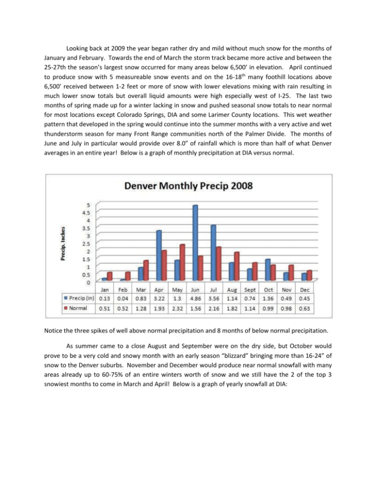
Looking back at 2009 the year began rather dry and mild without much snow for the months of January and February. Towards the end of March the storm track became more active and between the 25-27th the season’s largest snow occurred for many areas below 6,500’ in elevation. April continued to produce snow with 5 measureable snow events and on the 16-18th many foothill locations above 6,500’ received between 1-2 feet or more of snow with lower elevations mixing with rain resulting in much lower snow totals but overall liquid amounts were high especially west of I-25. The last two months of spring made up for a winter lacking in snow and pushed seasonal snow totals to near normal for most locations except Colorado Springs, DIA and some Larimer County locations. This wet weather pattern that developed in the spring would continue into the summer months with a very active and wet thunderstorm season for many Front Range communities north of the Palmer Divide. The months of June and July in particular would provide over 8.0” of rainfall which is more than half of what Denver averages in an entire year! Below is a graph of monthly precipitation at DIA versus normal. Notice the three spikes of well above normal precipitation and 8 months of below normal precipitation. As summer came to a close August and September were on the dry side, but October would prove to be a very cold and snowy month with an early season “blizzard” bringing more than 16-24” of snow to the Denver suburbs. November and December would produce near normal snowfall with many areas already up to 60-75% of an entire winters worth of snow and we still have the 2 of the top 3 snowiest months to come in March and April! Below is a graph of yearly snowfall at DIA: Temperatures in October would be extremely cold for historical standards becoming the 2nd coldest October on record. Average high temperatures in October were more than 11 degrees below normal. December would also be cold for Colorado standards finishing as the 7 th coldest December ever record. Below are graphs of high and low temperatures at DIA for the year: Notice how the trend was above normal temperatures for the first 5 months of the year then the last 7 months except September and November have all been below normal. 2009 proved to be a rather cool and wet year with a total of 18.12” recorded at DIA versus 14.79” on average resulting in a surplus of 3.33” for 2009. DIA was actually rather low on annual precipitation this year compared with other areas with many locations reporting over 20.0”. Here are some other Front Range yearly precipitation totals (reminder these yearly totals are not official, but will represent the locations fairly well): Aurora South 22.69” Broomfield 20.01” Centennial 22.31” Colorado Springs 15.74” Denver SE 22.44” Fort Collins 22.77” Golden 24.67” Highlands Ranch 23.93” Lakewood 24.04” Loveland 20.32 Wheatridge 24.22”
