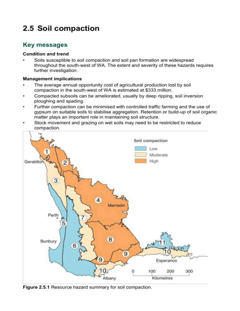
Hazard from soil-landscape mapping
advertisement

2.5 Soil compaction Key messages Condition and trend • Soils susceptible to soil compaction and soil pan formation are widespread throughout the south-west of WA. The extent and severity of these hazards requires further investigation. Management implications • The average annual opportunity cost of agricultural production lost by soil compaction in the south-west of WA is estimated at $333 million. • Compacted subsoils can be ameliorated, usually by deep ripping, soil inversion ploughing and spading. • Further compaction can be minimised with controlled traffic farming and the use of gypsum on suitable soils to stabilise aggregation. Retention or build-up of soil organic matter plays an important role in maintaining soil structure. • Stock movement and grazing on wet soils may need to be restricted to reduce compaction. Figure 2.5.1 Resource hazard summary for soil compaction. Table 2.5.1 Resource status and trends summary for soil compaction Ag Soil Ag Soil Zone Zone number Summary Hazard Trend Confidence in condition Confidence in trend 1 Mid West High Deteriorating Limited evidence or limited consensus Limited evidence or limited consensus 2 Mullewa to Morawa High Deteriorating Limited evidence or limited consensus Limited evidence or limited consensus 3 West Midlands Moderate Stable Limited evidence or limited consensus Limited evidence or limited consensus 4 Central Northern Wheatbelt High Deteriorating Limited evidence or limited consensus Limited evidence or limited consensus 5 Swan to Scott Coastal Plains Low Stable Limited evidence or limited consensus Limited evidence or limited consensus 6 Darling Range to South Coast Problem on Eradu sandplain. Soil pans occur on Northampton block in heavy textured soils. Soil structure decline on red soils leading to hard pans and compaction. Some siliceous hardpans have developed. Compaction is a severe problem on the yellow sandy earths, but less so on pale sands. Red soils are prone to crusting and forming hard pans on cropped soils. Some deep compaction occurs on yellow sandplain soils. No extensive cropping and limited use of heavy machinery. Soils not vulnerable. Forest soils resilient to compaction due to gravel content. Also there is limited cropping in this zone. Low Stable Limited evidence or limited consensus Limited evidence or limited consensus Ag Soil Ag Soil Zone Zone number Summary Hazard Trend Confidence in condition Confidence in trend 7 Zone of Rejuvenated Drainage Moderate Stable Limited evidence or limited consensus Limited evidence or limited consensus 8 Southern Wheatbelt High Deteriorating Limited evidence or limited consensus Limited evidence or limited consensus 9 Stirlings to Ravensthorpe High Deteriorating Limited evidence or limited consensus Limited evidence or limited consensus 10 South Coast – Albany to Esperance Moderate Stable Limited evidence or limited consensus Limited evidence or limited consensus 11 Salmon Gums Mallee Soils mainly resilient to compaction, but small areas of yellow soils are a problem as cropping becomes more common. Grey clays with declining soil structure are prone to collapse and compaction. Shallow soils and red soils are becoming a problem due to surface sealing and hardpan development. Deteriorating trend due to increased cropping. Some compaction on shallow duplex soils. Fine grey sands are less prone to compaction. Heavy machinery used less often. Soil structure problems and surface crusting but not much deep compaction. Low Stable Limited evidence or limited consensus Limited evidence or limited consensus Summary hazard grades Very low Low Moderate High Very high Soil hazard generally low and current land use highly unlikely to cause compaction Soil hazard generally low and current land use unlikely to cause compaction Soil hazard moderate and current land use likely to cause compaction Soil hazard generally high and current land use likely to cause compaction Soil hazard generally high and current land use highly likely to cause compaction Overview Soil compaction is a form of physical degradation resulting in densification and distortion of the soil. Biological activity, porosity and permeability are reduced, soil strength is increased and soil structure is partly destroyed. Poor root growth and waterlogging are common consequences. Soil compaction can occur at any level in the soil profile, although it is most commonly recognised as a dense and hard subsurface layer, which is less permeable to roots, water and oxygen than the soil beneath and is a constraint to crop growth. In agricultural areas, deeper compaction (to one metre or more) can be caused by the passage of machinery, especially heavily loaded wheels and tracks. Animals grazing on wet soils can also induce shallow crusting and surface compaction. The risk of soil compaction occurring has been increased in recent decades by the development of larger and heavier farm machinery. Hard layers in soils may also be the result of cementation (transient or permanent) of the soil particles by clay coatings, progressive precipitation of soluble compounds or precipitation of largely insoluble calcium carbonate, silica or iron. These processes are not covered in this chapter. Controlled traffic farming aims to place all vehicle wheels onto specific beds to minimise compaction across the paddock. (Photo: Western Australian No-Tillage Farmers Association (WANTFA). In most seasons soil compaction results in the loss of grain yield and quality. Subsurface compaction can occur in most Western Australian agricultural soils. Some soils have the capacity to resist compaction or to self-repair following compaction, particularly selfmulching soils. However, nearly three-quarters of WA’s soils are either affected by, or highly susceptible to, subsurface compaction. Subsurface compaction in a cropped Yellow sandy earth, Wongan Hills. Although little detail is known about the extent and severity of compaction and soil structure decline across the south-west of WA, the best estimate of the average opportunity cost of lost agricultural production is $333 million per year (Herbert 2009). In most cases these hardpans can be economically remedied and appropriate agricultural practices, such as controlled traffic farming, can minimise the formation of hardpans. Assessment method At present, despite the apparent importance of the issue, very little is known about the severity and extent of soil compaction. The best available information includes a hazard assessment based on soil-landscape factors, and information from farmer surveys. Hazard from soil-landscape mapping Spatial extent of compaction was derived from the soils and their properties described during DAFWA’s soil-landscape mapping of the south-west of WA. All soils within map units were assigned a hazard rating of not applicable, low, moderate or high. The hazard assessment is based on a combination of particle size distribution and presence or absence of soil structure and organic matter. Soils with a wide range of particle sizes, low organic matter and limited or no soil structure are particularly susceptible to compaction. Soil moisture, although an important factor in the development of this hazard, is not included in the assessment. However, the impact of soil moisture is covered in the discussion and implications section. The methodology for assessing the compaction hazard using soil-landscape mapping is described in van Gool et al. (2005). This assessment predicts soil compaction hazard, but it is not based on actual measurements. An independent survey of subsoil constraints to plant growth in the higher rainfall cropping areas (Evans et al. 2007) did not often encounter soil compaction on soils predicted by the above methodology. This difference may be because many areas have been cropped only recently (and hence compaction had not developed) and the use of smaller machinery. Observations from farmer surveys Farmer surveys provide land managers’ perspectives on current condition and trend from observations on their properties. Current status and trends Since monitoring of soil compaction has essentially been confined to trial sites, a hazard map has been generated from the soil-landscape mapping of the south-west of WA using key soil and landscape attributes. This map shows the proportion of land within each of the soil-landscape units with a high compaction hazard (Figure 2.5.2). Areas with mostly moderate hazard (e.g. the Esperance sandplain –DAFWA 2009) are not well represented in this map but are recognised in the summary map (Figure 2.5.1). Figure 2.5.2 Soil compaction hazard. The classes represent the proportion of the soillandscape map units with high soil compaction hazard. Farmer surveys Farmer surveys in several areas of the south-west of WA indicate that the issue of soil compaction is widespread but growers consider it a lesser constraint to production than other soil issues, such as acidity, water repellence and soil water holding capacity. There was no indication of any trend in the severity of compaction. A survey of 26 farmers of the Northern Agricultural Region in 2011 indicated compaction was the fourth-ranked issue (17%) behind water repellence, soil water holding capacity and acidity. A survey of 23 farmers in the Calingiri area in 2011 also indicated soil compaction was the fourth-ranked issue (14%). A survey of 30 farmers in the Hills/Darkan area in 2011 indicated compaction as a low constraint to production (6%), reflecting the tolerance of forest soils (gravelly) to trafficrelated compaction. A survey of 28 farmers in the West Midlands in 2010 indicated compaction as a minor constraint to production, well behind key issues, such as water repellence, soil water holding capacity and soil acidity. These results are not surprising given that sandy surfaced soils of low clay content dominate this area and are generally at low risk of compaction. Discussion and implications A number of processes lead to the formation and maintenance of hard layers in soil (Needham et al. 1998). Compaction is the main focus of this chapter, but it is just one process of hard layer formation in a soil. Some key principles The key factors leading to compaction, as with many other themes, is the combination of land characteristics, climate and land management. Land characteristics and climate The susceptibility of soils to compaction is related to soil texture. Soils that are sandy with very little clay and narrowly graded (a fairly uniform particle size) have a low susceptibility to compaction. Similarly, soils high in clay (uncommon in the south-west of WA) and soils high in gravel also have a low susceptibility to compaction. Conversely, soils with a mixture of particle sizes, such as sandy clay loams, are more likely to compact. In all soils, higher levels of organic matter and/or good structural development may reduce the risk of compaction. Moist soils are more likely to compact than those that are dry. Soils with a high inherent hazard of compaction that are trafficked by heavy machinery when moist are at greatest risk of subsurface compaction. Moreover, grazing animals on wet soils can cause both soil structure decline and surface compaction (Proffitt et al. 1993). Land management The most important land management factor affecting compaction is total load. Heavy machinery used on susceptible soils will cause compaction. The effect of traffic frequency on compaction depends on the initial condition of the soil. If it is initially loose (e.g. deepripped soil or newly cleared land), then most compaction will occur in the first pass. On a soil which is consolidated, but not compacted, compaction will increase with each pass; however, on WA’s sandy topsoils, most compaction occurs in the first four passes of machinery. Even with zero-tillage, more than 30% of the ground can be affected by normal vehicle traffic during a season of crop production (Tullberg 1990). With multiple passes, this can rapidly increase to 100% of the ground being covered by soil compaction (Soane et al. 1982). Stock trampling is also a significant cause of compaction, especially in the surface horizon of finer textured soils, but this compaction is usually confined to the top 15 cm of the profile. Compaction caused by heavy machinery occurs to a much greater depth, and is much harder to treat. General comments There is a paucity of data on the actual occurrence of compaction in the south-west of WA. Most research has concentrated on remedial processes and costs to farmers (Blackwell et al. 2013; Hamilton et al. 2005; Needham et al. 1998) with little emphasis on the extent of the problem. Implications for grain industries Soil compaction constrains the yield potential of susceptible soils. With heavier machinery being employed to maximise the efficiency of seeding, spraying and harvesting, there is a growing trend towards increased compaction. Remedial steps include reduced vehicle pressure on the soil, reduced vehicular traffic over the surface, restricting traffic to permanent positions (controlled traffic) in cropped paddocks and use of remedial soil treatments, such as soil inversion, spading (mixing top soil and subsoil) and deep ripping. These treatments must be protected from subsequent compaction by machinery if the full benefits of intervention are to be realised (Blackwell et al. 2013). Controlled traffic farming improves productivity by limiting compaction to wheel tracks. This photograph, taken in June 2013 at Wittenoom Hills, north-east of Esperance, demonstrates compaction contributing to waterlogging and reduced productivity in wheel tracks (yellow stripes) compared to the higher productivity inter-track spaces. Implications for livestock industries Soil compaction by animals can affect pasture growth directly (Proffitt et al. 1993) and therefore animal production from those pastures. Subsequent crop growth is indirectly affected by compaction following grazing due to restricted water infiltration and root growth. Implications for intensive agriculture industries Soil compaction can be a problem in vineyards. Machinery traffic between vines can affect root growth and possibly grape production. Ripping may also be detrimental to root growth, so other remedial techniques may be required. However, vineyards are not generally located on susceptible soils and irrigation and high fertiliser use can alleviate some of the adverse effects of soil compaction. Recommendations Collect more baseline data to fully assess the extent and severity of soil compaction, to enable better informed decisions about the level of investment needed to ameliorate the constraint. Support the development and implementation of land management practices (e.g. controlled traffic, increased soil organic carbon levels) that minimise the impact of compaction on agricultural production. Acknowledgements Authors: Dan Carter (DAFWA), Stephen Davies (DAFWA) and Noel Schoknecht (DAFWA). This chapter should be cited as: Carter D, Davies S and Schoknecht N (2013). ‘Soil compaction’. In: Report card on sustainable natural resource use in agriculture, Department of Agriculture and Food, Western Australia. General support for this chapter (coordination, editing, map production) is listed in the general acknowledgements. Sources of information Blackwell, P, Hagan, J, Davies, S, Riethmuller, G, Bakker, D, Hall, D, Knight, Q, Lemon, J. Yokwe, S and Isbister B (2013). Pathways to more grain farming profit by controlled traffic. 2013 Agribusiness Crop Updates, Perth. Davies, S and Lacey, A (2011). Subsurface compaction – A guide for WA farmers and consultants. Technical bulletin No. 4818, Department of Agriculture and Food, Western Australia. DAFWA (2009). Managing South Coast sandplain soils to yield potential. Bulletin 4773, Department of Agriculture and Food, Western Australia. Evans, D, Dixon, J, Davies, S, van Gool, D, Vernon, L & Gilkes, R (2007). Managing hostile subsoils in the high rainfall zone of south-western Australia. Resource management technical report 321, Department of Agriculture and Food, Western Australia. Hamilton, G, Fisher, P, Braimbridge, M, Bignell, J, Sheppard, J and Bowey, R (2005). Managing grey clays. Bulletin 4666, Department of Agriculture and Food, Western Australia. Herbert, A (2009). Opportunity costs of land degradation hazards in the South-West agricultural region. Resource management technical report 349, Department of Agriculture and Food, Western Australia. Needham, P, Scholz, G & Moore, G (1998). Chap. 4.1 Hard layers in soils and Chap 4.2 Subsoil compaction. In “Soilguide” A Handbook for understanding and managing agricultural soils. Bulletin 4343, Department of Agriculture and Food, Western Australia. Proffitt, APB, Bendotti, S, Howell, MR & Eastham, J (1993). The effect of sheep trampling and grazing on soil physical properties and pasture growth for a red-brown earth. Aust. J Agric Res. 44, 317-31. Soane, BD, Dickson, JW & Campbell, DJ (1982). Compaction by agricultural vehicles: a review III Incidence and control of compaction in crop production Soil Tillage Res. 2, 336. Tullberg, JN (1990). Why control traffic? Proceedings soil compaction conference Qld. Dept Primary Industries. van Gool, D Tille, P and Moore, G (2005). Land evaluation standards for land resource mapping. Resource management technical report 298, Department of Agriculture and Food, Western Australia.


