Timber Harvesting (Coupe) Plan
advertisement
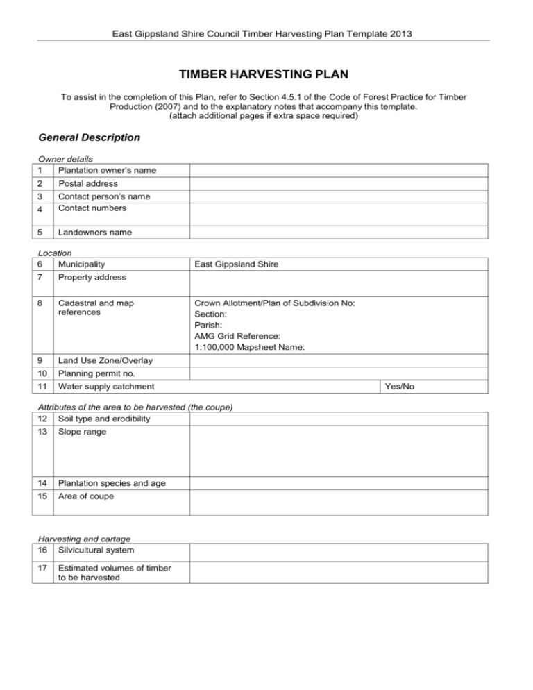
East Gippsland Shire Council Timber Harvesting Plan Template 2013 TIMBER HARVESTING PLAN To assist in the completion of this Plan, refer to Section 4.5.1 of the Code of Forest Practice for Timber Production (2007) and to the explanatory notes that accompany this template. (attach additional pages if extra space required) General Description Owner details 1 Plantation owner’s name 2 Postal address 3 4 Contact person’s name Contact numbers 5 Landowners name Location 6 Municipality 7 Property address 8 Cadastral and map references 9 Land Use Zone/Overlay 10 Planning permit no. 11 Water supply catchment East Gippsland Shire Crown Allotment/Plan of Subdivision No: Section: Parish: AMG Grid Reference: 1:100,000 Mapsheet Name: Attributes of the area to be harvested (the coupe) 12 Soil type and erodibility 13 Slope range 14 Plantation species and age 15 Area of coupe Harvesting and cartage 16 Silvicultural system 17 Estimated volumes of timber to be harvested Yes/No East Gippsland Shire Council Timber Harvesting Plan Template 2013 18 Harvesting contractor 19 Harvesting equipment 20 Scheduled harvesting period 21 Cartage contractor 22 Proposed timber cartage route(s) Conditions applying to the Harvesting Operations Protection of environmental values (Code ref 4.2) 1 2 3 Waterways: water quality and soil protection Slope limitations Conservation of biodiversity Roading (Code ref 4.4) 4 5 6 7 8 Road planning and design Road construction Road maintenance Suspension of cartage Road closures Plantation Infrastructure (Code ref 4.5.2) 9 10 Log landings and dumps Snig tracks and forwarding tracks Other operational measures 11 12 13 14 15 Wet weather and seasonal restrictions Powerline protection measures Protection of landscape values Fire protection measures Other harvesting operational requirements The attached Coupe Map forms part of this Timber Harvesting Plan Plan prepared by: ………………………………………. Signature:.……………………………………………………..Date: …………………….. Plan lodged with:..…………………………………………….Date:…………………… (Municipality) Plan lodgment acknowledged: ………………………………….Date: ……………………. (Receiving Officer) East Gippsland Shire Council Timber Harvesting Plan Template 2013 Timber Harvesting Plan Amendments Amendment No Date THP item no. Amendment ................................................................................................................................................................................... ................................................................................................................................................................................... ................................................................................................................................................................................... ................................................................................................................................................................................... Amendments prepared by: …………………………………… Signed: ….…………………………………… Amendments lodged with responsible authority Date:…………………………. Date: …………………………. East Gippsland Shire Council Timber Harvesting Plan Template 2013 TIMBER HARVESTING PLAN Coupe Map Legend Coupe boundary Areas of 30 degree slope or greater Streams, pools and wetlands Drainage lines Log landings and dumps Existing roads and tracks Roads to be constructed or upgraded Bridges, culverts Quarries, gravel and borrow pits Powerlines Soil erosion hazard classes Coupe ID Scale Snig forwarding tracks 1: Designated crossings on waterways for machinery Areas excluded from harvesting Map Source Other special condition areas Fuel dumps, machinery servicing areas Firebreaks Other: _____ North East Gippsland Shire Council Timber Harvesting Plan Template 2013 TIMBER HARVESTING PLAN EXPLANATORY NOTES. These notes may assist you to complete the Timber Harvesting Plan. These notes should be read in conjunction with the Code of Practice for timber production 2007 (Chapter 4). General Description Unless indicated otherwise, the term forest is used to refer to plantation or native forest (on private land). 1. Plantation owner’s name Name, in full, of the person(s)/company who own(s) the forest area to be harvested. 2. Postal address Address for correspondence to the plantation owner. 3. Contact persons name Name of plantations owners representative, where. 4. Contact numbers Contact numbers for plantation owner or representative. 5. Landowners name Name of person(s)/company who own(s) the land, if different to the plantation owner (eg. If the plantation is on leased land). Plantation location 6. Municipality The name of the Shire/City in which the forest area to be harvested is located. 7. Property address The physical address of the property/land using local road and township names and or Municipal Property No. 8. Cadastral and map references Describe the location of the area to be harvested (coupe) by providing the details indicated. 9. Land Use Zone/Overlay Refer to the relevant Municipal Planning Scheme map to identify how the land on which the plantation is located is Zoned, and whether it is affected by an Overlay. 10. Planning permit number Reference number for relevant Planning Permit (for plantation establishment) issued, if applicable. 11. Water supply catchment Indicate if the area to be harvested is in a Designated Water Supply Catchment. Refer to Department of Environment and Primary Industries website (www.dpi.vic.gov.au) Attributes of the plantation area to be harvested (the coupe) 12. Soil type and erodibility A general description (soil profile, texture, colour, structure) of the coupe’s soils and their relative stability (proneness to erosion). (eg. heavy yellow clay, low erosion potential; or, Gradational sandy loam (granite sand), easily erodible). Any variation in soil type across the coupe should be noted. 1 East Gippsland Shire Council Timber Harvesting Plan Template 2013 13. Slope range The range of slopes encountered on the land to be harvested, from the gentlest to the steepest. The slope of the land is measured using a clinometer, or calculated from a large scale contour map, and is expressed in degrees (eg. min 12° to max 25°). 14. Plantation species and age Indicate the species and stand age of the plantation. 15. Area of coupe The net area to be harvested, in hectares. This figure does not include areas reserved from harvesting within the coupe boundary. Harvesting and cartage 16. Silvicultural system Silviculture refers to the management actions undertaken in a plantation to influence its growth, harvest, and regeneration or re-establishment. Here you should indicate the intended harvesting system (eg. clearfall; seed tree; shelter wood; selection), and the intended regeneration/re-establishment method (eg. hand plant with seedlings; natural seed fall following burning of logging debris). An intermediate harvest to reduce tree stocking is called a thinning. 17. Estimated volumes of timber to be harvested Estimate the volume (cubic metres or tonnes) of each type of wood product that is expected to be produced from the coupe (eg. 500 cubic metres saw logs, 800 cubic metres pulpwood, 300 tonnes firewood). 18. Harvesting contractor Name of the person/contractor/company who will carry out the harvesting operation. 19. Harvesting equipment Description of equipment and techniques to be used to fell trees and extract the logs within the coupe (eg. chainsaw and skidder; harvester and forwarder; chainsaw and cable). 20. Scheduled harvesting period Indicate the anticipated commencement and completion dates of harvesting. 21. Cartage contractor Name of the person/contractor/company who will carry out log cartage from the coupe. 22. Proposed cartage route (s) Indicate the road route(s) by which the wood is to be carted, from the coupe to destination(s) or to entry onto a highway. 2 East Gippsland Shire Council Timber Harvesting Plan Template 2013 Section B. Conditions applying to the harvesting operations The Timber Harvesting Plan needs to indicate how all the relevant provisions of the Code are to be applied to the particular harvesting area (coupe) for which it has been prepared. The operational goals, mandatory actions, and guidance set out in the Code need to be considered and appropriate responses explicitly documented in the Timber Harvesting Plan. Conditions applied to harvesting operations covered by the Timber Harvesting Plan may need to exceed the minimum requirements outlined in the Code to reflect other Statutory obligations (eg Planning Permit conditions, State Environmental Protection Policies), or where required to protect environmental values. The location and nature of many of the conditions to apply to the timber harvesting operations will also need to be indicated on the map that forms part of the Timber Harvesting Plan. Refer to the explanatory notes for guidance on map preparation in Section C below. For effective translation of the Timber Harvesting Plan to the on-coupe harvesting operation, it will generally be necessary for the forest owner to arrange for the location of coupe boundaries, log landing and dum ps, r oad alig nment s, and ot her areas req uir ing special att ent ion t o be marked in t he f ield. Any amendments made to the Timber Harvesting Plan after it is prepared and lodged need to be noted in the Amendment Table of the plan and recorded on the Coupe Map as appropriate. A copy of the amended Timber Harvesting Plan needs to be lodged with the responsible authority. Protection of environmental values (Code ref 4.2) 1. Waterways: water quality and soil protection ( Code ref 4.2.1) Indicate measures to be taken to control timber harvesting operations in the vicinity of waterways to protect them, and any associated riparian vegetation, from disturbances and exposure that could reduce water quality. Also, outline measures that will be undertaken to protect and rehabilitate souls. Specify any restrictions that apply to harvesting and machinery in the vicinity of waterways. 2. S l o p e l i m i t a t i o n s ( C o d e r e f 4 . 2 . 1 ) Specify the maximum slope on which harvesting will be carried out on this coupe. Mark the location of any areas where the maximum slope is exceeded on the coupe map. 3. Conservation of biodiversity (Code ref 4.2.2) Specify any other areas where harvesting is to be excluded or restricted for biodiversity conservation purposes, such as areas of native vegetation, and indicate any special conditions or prescriptions appropriate to protecting these areas. Mark these areas on the coupe map. Roading and cartage (Code ref 4.4) 4. Road planning and design (Code refs 4.4.1 and 4.4.2) Specify the type, location and design standards for any new or upgraded timber roads including stream crossings, and road infrastructure such as culverts, drains, batters, bridges and fords. Mark the location of existing, new or upgraded roads on the coupe map. 5. Road construction (Code 4.4.3) Specify measures to be taken to protect water yield where applicable. Specify the construction methods of any new or upgraded timber roads and the location of any quarries, gravel and borrow pits. Specify the design and drainage measures required to minimize soil erosion, mass soil movement, water quality deterioration and landscape impact. Mark the location of any quarries, pits or fill disposal areas on the coupe map. 3 East Gippsland Shire Council Timber Harvesting Plan Template 2013 6. Slope limitations (Code ref 3.2.5) Road maintenance (Code ref 4.4.4) Specify the maximum slope on which harvesting will be carried out on this coupe. Mark the location of any areas where the maximum slope is exceeded on the coupe map. Specify any maintenance works to road surfaces, road edges, and road drainage systems re quired to protect the road foundation and to disperse and filter water before it enters streams. 7. Conservation of flora and fauna (Code ref 3.2.6) Suspension of cartage (Code ref 4.4.5) Specify weather or road surface moisture conditions when roads are to be closed to timber traffic to avoid threatening water quality or the integrity and serviceability of the road. 8. Road closures (4.4.6) Specify the rehabilitation measures to be taken where roads are to be closed, either temporarily or permanently. Plantation Infrastructure (Code ref 4.5.2) 9. Log landings and dumps (Code ref 4.5.2) Specify conditions relating to the location, construction and maintenance of log landings and log dumps to minimise soil degradation and water quality deterioration. Specify the rehabilitation measures to be undertaken on the landings and dumps when the sites are no longer required. Mark the location of log landings and dumps on the coupe map. 10. Snig tracks and forwarding tracks (Code ref 4.5.2) Specify conditions relating to the location and use of snigging and forwarding tracks to minimise adverse impact on soil and water quality. Outline the rehabilitation measures to be undertaken on snig/forwarding tracks at the completion of harvesting operations. Mark the location of major snig and forwarding tracks on the coupe map. Other operational measures 11. Wet weather and seasonal restrictions (Code ref 4.5.3) Specify conditions when timber harvesting operations (particularly snigging, forwarding and landing operations) must be restricted or stopped when soils are wet and there is a risk to soil and water values (suspension of cartage at item 7). 12. Power line protection measures (Code ref 4.5) Specify conditions regarding harvesting operations near power lines (where required) 13. Protection of landscape values (Code ref 4.1) Specify any measures to be taken to protect landscape values. 14. Fire protection measures Specify conditions regarding fire protection, including fire fighting equipment required and restrictions of certain activities on days of extreme fire danger. 15. Other harvesting operational requirements Specify any conditions relating to aspects of the harvesting operations not covered above. This could include instructions to the harvesting contractor on matters not covered by the Code, eg. Maximum stump height, log grading standards etc. 4 East Gippsland Shire Council Timber Harvesting Plan Template 2013 Section C. Coupe Map Preparation A map of the area to be harvested (coupe) must form part the Timber Harvesting Plan (Code ref 4.5.1). Map scale Ideally the chosen map scale is such that the area to be harvested occupies approximately 50 -75% of the page when drawn on an A4 sheet. Often this would mean a map scale of 1:10,000 or larger. A smaller scale (down to 1:25,000) can be used for larger coupes which are uniform in nature. A map showing contours is preferable. In most instances, a satisfactory base map can be produced by enlarging the appropriate section from a 1:25,000 topographic map (Vicmap series). Standard map information Standard map information includes: • a north arrow, • the map scale, • the source of the map; and • a legend showing the map symbols used to represent features and operational conditions. Coupe and harvesting information The Code stipulates that the Timber Harvesting Plan must include a map showing: • the plantation or coupe location; • the area(s) to be harvested; • new or upgraded roads; • power lines; • plantation infrastructure (including log landings and dumps, and snigging and forwarding tracks). Other information that may usefully be shown on a Timber Harvesting Plan coupe map includes: • other areas excluded from harvesting, or to which special conditions apply; • existing roads and tracks (including roads to be used for log cartage); • bridges and culverts; • designated crossings on waterways for machinery (including temporary crossings); • quarries, pits and fill disposal areas; • soil erosion hazard classes of the coupe area; • fuel dumps and machinery servicing areas; and • any existing or new firebreaks. Supporting information In addition to the Timber Harvesting Plan coupe map showing the information listed above, the following supporting information is helpful, and its inclusion with a Timber Harvesting Plan is encouraged where it is available: • • • a smaller scale map (1:25,000 or 1:50,000 scale) of A4 size, showing the general locality of the area to be harvested, a map showing the cadastral details (Parish, Crown allotment) of the land on which the harvesting is to occur, a copy of a recent aerial photograph of the area to be harvested. 5 East Gippsland Shire Council Timber Harvesting Plan Template 2013 6 East Gippsland Shire Council Timber Harvesting Plan Template 2013 7 East Gippsland Shire Council Timber Harvesting Plan Template 2013 8 East Gippsland Shire Council Timber Harvesting Plan Template 2013 9

