Schedule 6 to the Urban Growth Zone
advertisement
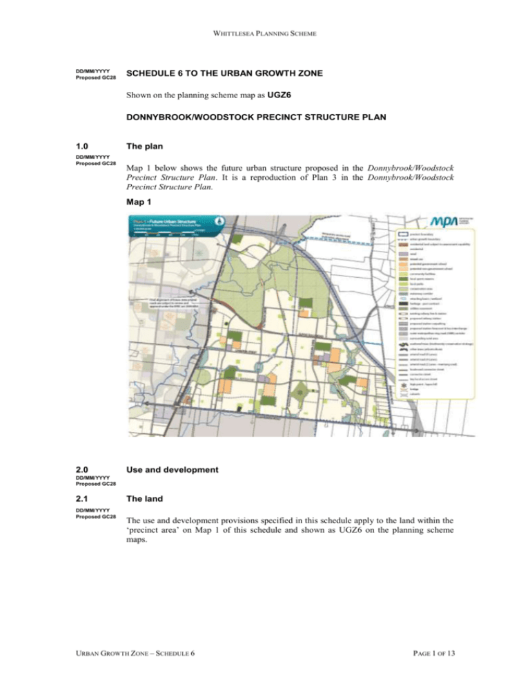
WHITTLESEA PLANNING SCHEME DD/MM/YYYY Proposed GC28 SCHEDULE 6 TO THE URBAN GROWTH ZONE Shown on the planning scheme map as UGZ6 DONNYBROOK/WOODSTOCK PRECINCT STRUCTURE PLAN 1.0 DD/MM/YYYY Proposed GC28 The plan Map 1 below shows the future urban structure proposed in the Donnybrook/Woodstock Precinct Structure Plan. It is a reproduction of Plan 3 in the Donnybrook/Woodstock Precinct Structure Plan. Map 1 2.0 Use and development DD/MM/YYYY Proposed GC28 2.1 DD/MM/YYYY Proposed GC28 The land The use and development provisions specified in this schedule apply to the land within the ‘precinct area’ on Map 1 of this schedule and shown as UGZ6 on the planning scheme maps. URBAN GROWTH ZONE – SCHEDULE 6 PAGE 1 OF 13 WHITTLESEA PLANNING SCHEME 2.2 Applied zone provisions DD/MM/YYYY Proposed GC28 The provisions of the following zones in this scheme apply to the use and subdivision of the land, the construction of a building and the construction or carrying out of works as set out in Table 1. Table 1: Applied zone provisions Land use or development (carried out or proposed) generally in accordance with the precinct structure plan applying to the land Applied zone provisions Retail Clause 34.01 – Commercial 1 Zone Arterial road (6 lanes) Clause 36.04 – Road Zone – Category 1 Outer Metropolitan Ring Transit Corridor 2.3 DD/MM/YYYY Proposed GC28 Arterial road (4 lanes) Clause 36.04 – Road Zone – Category 2 Mixed Use Clause 32.07 – Residential Growth Zone All other land Clause 32.08 – General Residential Zone Reference to a planning scheme zone is a reference to an applied zone A reference to a planning scheme zone in an applied zone must be read as if it were a reference to an applied zone under this schedule. Note: e.g. The General Residential Zone specifies ‘Car wash’ as a Section 2 Use with the condition, ‘The site must adjoin, or have access to, a road in a Road Zone.’ In this instance the condition should be read as, ‘The site must adjoin, or have access to, a road in a Road Zone or an applied Road Zone in the Urban Growth Zone schedule applying to the land’. 2.4 Specific provision – Use and development of future public land DD/MM/YYYY Proposed GC28 2.5 A permit is not required to use or develop land shown in the Donnybrook/Woodstock Precinct Structure Plan as local park, local sports reserve or community facilities provided the use or development is carried out generally in accordance with the Donnybrook/ Woodstock Precinct Structure Plan and with the prior written consent of Whittlesea City Council. Specific provisions – Use of land DD/MM/YYYY Proposed GC28 Table 2: Use Use Requirement Primary school A permit is not required to use land for a Primary school on land shown as Potential Non-Government School P-6 or P-12 in the Donnybrook/Woodstock Precinct Structure Plan. Secondary school A permit is not required to use land for a Secondary school on land shown as Potential Non-Government School P-12 or 7-12 in the Donnybrook/Woodstock Precinct Structure Plan. URBAN GROWTH ZONE – SCHEDULE 6 PAGE 2 OF 13 WHITTLESEA PLANNING SCHEME Use Shop where the applied zone is Commercial 1 Zone 2.6 Requirement A permit is required to use land for a shop if the combined leasable floor area of all shops exceeds: 1000 square metres for land shown as retail in the Donnybrook Farmhouse Local Town Centre (LCC1) in the incorporated Donnybrook/Woodstock Precinct Structure Plan. 2500 square metres for land shown as retail in Donnybrook Station Local Convenience Centre (LCC2) in the incorporated Donnybrook/Woodstock Precinct Structure Plan. 1000 square metres for land shown as retail in Lockerbie Station Local Convenience Centre (LCC3) in the incorporated Donnybrook/Woodstock Precinct Structure Plan. 500 square metres for land shown as retail in Hayes Hill Local Convenience Centre (LCC4) in the incorporated Donnybrook/Woodstock Precinct Structure Plan. 1500 square metres for land shown as retail in Woodlands Local Convenience Centre (LCC5) in the incorporated Donnybrook/Woodstock Precinct Structure Plan. 21,500 square metres for land shown as retail in Koukoura Drive Local Town Centre (LTC1) in the incorporated Donnybrook/Woodstock Precinct Structure Plan. 10,000 square metres for land shown as retail in Patterson Drive Local Town Centre (LTC2) in the incorporated Donnybrook/Woodstock Precinct Structure Plan. 4500 square metres for land shown as retail in Lockerbie East Local Town Centre (LTC3) in the incorporated Donnybrook/Woodstock Precinct Structure Plan. 2000 square metres for land shown as retail in Darebin Creek Local Town Centre (LTC4) in the incorporated Donnybrook/Woodstock Precinct Structure Plan. Specific provision – Construction of single dwellings on small lots DD/MM/YYYY Proposed GC28 A permit is not required to construct or extend one dwelling on a lot with an area less than 300 square metres where a site is identified as a lot to be assessed against the Small Lot Housing Code via a restriction on title, and it complies with the Small Lot Housing Code incorporated pursuant to Clause 81 of the Whittlesea Planning Scheme. 2.7 DD/MM/YYYY Proposed GC28 Specific provison – Construction management plan required in gas transmission pipeline protection area Any application, on land shown as gas pipeline buffer on Plan 2 – Precinct Features in the incorporated Donnybrook/Woodstock Precinct Structure Plan, is required to provide a construction management plan submitted to and approved by the responsible authority and the operator of the gas transmission pipeline. The plan must: URBAN GROWTH ZONE – SCHEDULE 6 PAGE 3 OF 13 WHITTLESEA PLANNING SCHEME Prohibit the use of rippers or horizontal directional drills unless otherwise agreed by the operator of the gas transmission pipeline. Demonstrate how pipeline crossing protection measures are to be engineered to ensure that gas assets are not detrimentally affected. Works to be examined include structures, pavement, pipelines, cables and fences. Demonstrate how safety and risk is managed in accordance with AS2885 Australian Standard Pipelines - Gas and Liquid Petroleum. Include a landscape plan for all landscaping on the site. Include any other relevant matter to the satisfaction of the responsible authority. The safety management plan must be implemented to the satisfaction of the responsible authority. The safety management plan may be amended to the satisfaction of the responsible authority. 2.8 DD/MM/YYYY Proposed GC28 3.0 DD/MM/YYYY Proposed GC28 3.1 Specific provision – buildings and works for a school A permit is required to construct a building or construct or carry out works associated with a Primary School or Secondary School on land shown as a non-government school unless exempt under Clauses 62.02-1 and 62.02-2. Application requirements If in the opinion of the responsible authority an application requirement listed below is not relevant to the assessment of an application, the responsible authority may waive or reduce the requirement. Subdivision – Residential development DD/MM/YYYY Proposed GC28 In addition to the requirements of Clause 56.01-2, a subdivision design response for a residential subdivision must include, to the satisfaction of the responsible authority: A land budget table in the same format and methodology as those within the precinct structure plan applying to the land, setting out the amount of land allocated to the proposed uses and expected population, dwelling and employment yields; A demonstration of how the property will contribute to the achievement of the residential density outcomes in the precinct structure plan applying to the land; A demonstration of lot size diversity by including a colour coded lot size plan, reflecting the lot size categories and colours outlines in Table 2 - Lot size and Housing Type Guide in the Donnybrook/Woodstock Precinct Structure Plan; A mobility plan that demonstrates how the local street and movement network integrates with adjacent urban development or is capable of integrating with future development on adjacent land parcels; An arboricultural report identifying all tress on the site and a tree retention plan identifying how the application responds to Plan 4 – Image and Character and any tree protection requirements and guidelines within the Donnybrook/Woodstock Precinct Structure Plan; Potential bus route and bus stop locations prepared in consultation with Public Transport Victoria; Subdivision and Housing Design Guidelines, prepared to satisfaction of the responsible authority, which demonstrates how the proposal responds to and achieves the objectives and planning and design requirements and guidelines whom within the “Housing” URBAN GROWTH ZONE – SCHEDULE 6 PAGE 4 OF 13 WHITTLESEA PLANNING SCHEME section of the Donnybrook/Woodstock Precinct Structure Plan incorporated into this scheme; A Site Management Plan that addresses bushfire risk during, and where necessary, after construction which is approved by the CFA. The plan must specify, amongst other things: 3.2 The staging of development and the likely bushfire risks at each stage; An area of land between the development edge and non-urban areas consistent with the separation distances specified in AS3959-2009, where bushfire risk is managed; The measures to be undertaken by the developer to reduce the risk from fire within any surrounding rural or undeveloped landscape and protect residents and property from the threat of fire; How adequate opportunities for access and egress will be provided for early residents, construction workers and emergency vehicle. Public Infrastructure Plan DD/MM/YYYY Proposed GC28 An application must be accompanied by a Public Infrastructure Plan which addresses the following: A Stormwater Management Strategy that assesses the existing surface and subsurface drainage conditions on the site, addresses the provision, staging and timing of stormwater drainage works, including temporary outfall provisions, to the satisfaction of Whittlesea City Council and Melbourne Water. What land may be affected or required for the provision of infrastructure works. The provision, staging and timing of stormwater drainage works. The provision, staging and timing of road works internal and external to the land consistent with any relevant traffic report or assessment. The landscaping of any land. What, if any, infrastructure set out in the Precinct Infrastructure Plan in the incorporated Donnybrook/Woodstock Precinct Structure Plan is sought to be provided as "works in lieu" subject to the consent of the collecting agency. The provision of public open space and land for any community facilities. Any other matter relevant to the provision of public infrastructure required by the responsible authority. 3.3 DD/MM/YYYY Proposed GC28 Use or develop land for a sensitive purpose – Environmental Site Assessment – “High Potential for Contamination” areas An application to develop land for a sensitive use (accommodation, child care centre, kindergarten, primary school or public open space) for areas ranked as ‘High Potential for Contamination’ in the Growth Areas Authority - Woodstock Precinct Structure Plan 1096, Environmental, Hydrological & Geotechnical Assessment (Meinhardt, June 2013) and the Growth Areas Authority - Donnybrook Precinct Structure Plan 1067, Environmental, Hydrological & Geotechnical Assessment (Meinhardt, June 2013) as identified in Table 3 of this schedule, must be either accompanied by: a certificate of environmental audit issued for the land in accordance with Part IXD of the Environment Protection Act 1970, or a statement by an environmental auditor appointed under the Environment Protection Act 1970 in accordance with Part IXD of that Act that the environmental conditions of the land are suitable for the sensitive use. URBAN GROWTH ZONE – SCHEDULE 6 PAGE 5 OF 13 WHITTLESEA PLANNING SCHEME Table 3 Address 3.4 DD/MM/YYYY Proposed GC28 Legal Description 1025 Donnybrook Road, Donnybrook Lot 1 TP843230 only 895A & 895B Donnybrook Road, Donnybrook Lot 3 PS334583 855 Donnybrook Road, Donnybrook Lot 1 PS334583 875 Donnybrook Road, Donnybrook Lot 2 PS334583 835 Donnybrook Road, Donnybrook Lot 2 PS449806 905 Donnybrook Road, Donnybrook Lot 1 TP663551 915 Donnybrook Road, Donnybrook Lot 1 TP248727 975 Donnybrook Road, Donnybrook Lot 1 TP444829 1085 Merriang Road, Woodstock Lot 8 LP56455 1131 Merriang Road, Woodstock Lot 1 LP83456 1135 Merriang Road, Woodstock Lot 3 LP56455 1145 Merriang Road, Woodstock Lot 2 LP99885 1165 Merriang Road, Woodstock Lot 1 LP99885 1305 Donnybrook Road, Woodstock Lot 2 LP130685 1285 Donnybrook Road, Woodstock Lot 1 LP130685 1145 Donnybrook Road, Woodstock Lot 2 LP208748 only 1315 Merriang Road, Woodstock Lot 2 LP123745 Use or develop land for a sensitive purpose – Environmental Site Assessment - “Medium Potential for Contamination” areas An application to develop land, as identified in Table 4 of this schedule, for a sensitive use (accommodation, child care centre, kindergarten, primary school or public open space) must be accompanied by a Phase 2 Environmental Site Assessment, including intrusive soil investigation of the Environmental Assessment Areas ranked as ‘Medium Potential for Contamination’ in the Growth Areas Authority - Woodstock Precinct Structure Plan 1096, Environmental, Hydrological & Geotechnical Assessment (Meinhardt, June 2013) and the Growth Areas Authority - Donnybrook Precinct Structure Plan 1067, Environmental, Hydrological & Geotechnical Assessment (Meinhardt, June 2013). The assessment must provide for the following information: Further detailed assessment of potential contaminants on the relevant land. Clear advice on whether the environmental condition of the land is suitable for the proposed use/s and whether an environmental audit of all, or part, of the land is recommended having regard to the Potentially Contaminated Land General Practice Note June 2005, DSE. Further detailed assessment of surface and subsurface water conditions and geotechnical characteristics on the relevant land and the potential impacts on the proposed development including any measures required to mitigate the impacts of groundwater conditions and geology on the development and the impact of the development on surface and subsurface water. Recommended remediation actions for any potentially contaminated land. Table 4 Address URBAN GROWTH ZONE – SCHEDULE 6 Legal Description PAGE 6 OF 13 WHITTLESEA PLANNING SCHEME 3.5 DD/MM/YYYY Proposed GC28 825 Donnybrook Road, Donnybrook Lot 1 PS449806 845 Donnybrook Road, Donnybrook Lot 1 TP827515 1085 Donnybrook Road, Donnybrook Lot 1 LP77367 1025 Merriang Road, Woodstock Lot 14 LP64456 1343-1345 Donnybrook Road, Woodstock Lot 16 LP56455 1325 Donnybrook Road, Woodstock Lot 17 LP56455 1035 Merriang Road, Woodstock Lot 13 LP56455 1045 Merriang Road, Woodstock Lot 12 LP56455 1055 Merriang Road, Woodstock Lot 11 LP56455 1065 Merriang Road, Woodstock Lot 10 LP56455 1075 Merriang Road, Woodstock Lot 9 LP56455 1105 Merriang Road, Woodstock Lot 2 LP82581 1115 Merriang Road, Woodstock Lot 1 LP82581 1125 Merriang Road, Woodstock Lot 2 LP83456 1265 Donnybrook Road, Woodstock Lot 19 LP56455 1255 Donnybrook Road, Woodstock Lot 20 LP56455 1145 Donnybrook Road, Woodstock Lot 1 LP208748 1235 Merriang Road, Woodstock Lot 2 TP366337 only Kangaroo management An application for subdivision must be accompanied by a Kangaroo Management Plan to the satisfaction of the responsible authority which includes: strategies to avoid land locking kangaroos, including staging of subdivision; and management requirements to respond to the containment of kangaroos in an area with no reasonable likelihood of their continued safe existence; or management and monitoring actions to sustainably manage a population of kangaroos within a suitable location. Where a Kangaroo Management Plan has been approved in respect to the land to which the application applies, the application must be accompanied by: a copy of the approved Kangaroo Management Plan; and a ‘design/management response’ statement outlining how the application is consistent with and gives effect to any requirements of the approved Kangaroo Management Plan. 3.6 Traffic Impact Assessment DD/MM/YYYY Proposed GC28 An application that proposes to create or change access to a primary or secondary arterial road must be accompanied by a Traffic Impact Assessment Report (TIAR). The TIAR, including functional layout plans and a feasibility/concept road safety audit, must be to the satisfaction of VicRoads or the Whittlesea City Council, as required. URBAN GROWTH ZONE – SCHEDULE 6 PAGE 7 OF 13 WHITTLESEA PLANNING SCHEME 3.7 DD/MM/YYYY Proposed GC28 3.8 DD/MM/YYYY Proposed GC28 Dry Stone Walls Any application on land which accommodates a dry stone wall, as identified on Plan 2 of the Donnybrook/Woodstock Precinct Structure Plan, and as surveyed, must be accompanied by a Dry Stone Wall Management Plan which responds to the relevant objectives, requirements and guidelines contained within the Donnybrook/Woodstock Precinct Structure Plan. Heritage Conservation Management Plans and Heritage Assessments A Heritage Conservation Management Plan must be undertaken for places identified on the Heritage Overlay or listed on the Victorian Heritage Inventory. The Heritage Conservation Management Plan must include a statement of significance/cultural value, appropriate site boundaries where subdivision is proposed, required restoration works, a schedule identifying essential urgent restoration works and potential future restoration works, an interpretive reuse plan, and interpretive signage, to the satisfaction of the responsible authority. Heritage Conservation Management Plans must be secured via an appropriate legal mechanism such as an agreement pursuant to section 173 of the Planning and Environment Act 1987 to the satisfaction of the responsible authority. Where a site is identified including a “Drystone Wall” on Plan 2 – Precinct Features in the Donnybrook/Woodstock Precinct Structure Plan but not included on the Heritage Overlay or Heritage Inventory, a heritage assessment identifying a statement of significance/cultural value, to the satisfaction of the responsible authority is required to be submitted with an application for a permit. 3.9 Specific provision – Within 50 metres of Conservation Areas DD/MM/YYYY Proposed GC28 Any application to subdivide land, to construct a building and to construct or carry out works, within 50 metres of a Conservation Area identified in the precinct structure plan must comply with the conservation interface requirements specified in the precinct structure plan to the satisfaction of the Secretary to the Department of Environment, Land, Water and Planning, unless with the approval of the responsible authority. Note: Operation of Commonwealth Environmental Laws. On 5 September 2013 an approval under the Environmental Protection and Biodiversity Conservation Act 1999 (EPBC Act) was issued by the Commonwealth Minister for Environment, Heritage and Water. The approval applies to all actions associated with urban development in growth corridors in the expanded Melbourne 2010 Urban Growth Boundary as described in page 4 in the Biodiversity Strategy for Melbourne’s Growth Corridors (Department of Environment and Primary Industries, 2013). The Commonwealth approval has effect until 31 December 2060. The approval is subject to conditions specified at Annexure 1 of the approval. Provided the conditions of the EPBC Act approval are satisfied individual assessment and approval under the EPBC Act is not required. URBAN GROWTH ZONE – SCHEDULE 6 PAGE 8 OF 13 WHITTLESEA PLANNING SCHEME 4.0 Conditions and requirements for permits DD/MM/YYYY Proposed GC28 4.1 DD/MM/YYYY Proposed GC28 Subdivision permits that allow the creation of a lot of less than 300 square metres Prior to certification of the Plan of Subdivision for the relevant stage, a plan must be submitted for approval to the satisfaction of the responsible authority. The plan must identify the lots that will include a restriction on title allowing the use of the provision of the Small Lot Housing Code incorporated pursuant to Clause 81 of the Whittlesea Planning Scheme. The Plan of Subdivision submitted for certification must identify whether Type A or Type B of the Small Lot Housing Code applies to each lot to the satisfaction of the responsible authority. 4.2 DD/MM/YYYY Proposed GC28 4.3 DD/MM/YYYY Proposed GC28 4.4 DD/MM/YYYY Proposed GC28 Land required for community facilities Land required for community facilities, as set out in the Donnybrook/Woodstock Precinct Structure Plan must be transferred to or vested in Council at no cost to Council. Open space Land required for a park as set out in the Donnybrook/Woodstock Precinct Structure Plan must be transferred to or vested in Council at no cost to Council. Biodiversity and threatened species Any permit for subdivision must contain the following conditions: Kangaroo Management Plan Before the certification of the plan of subdivision, a Kangaroo Management Plan must be approved by the Secretary to the Department of Environment, Land, Water and Planning. Once approved the plan will be endorsed by the responsible authority and form part of the permit. The endorsed Kangaroo Management Plan must be implemented to the satisfaction of the responsible authority Salvage and translocation The Salvage and Translocation Protocol for Melbourne’s Growth Corridors (Department of Environment and Primary Industries, 2014) must be implemented in the carrying out of development to the satisfaction of the Secretary to the Department of Environment, Land, Water and Planning. Environment Management Plans A planning permit for subdivision or buildings or works on land shown as a conservation area in the incorporated Donnybrook/Woodstock Precinct Structure Plan must include the following condition: Prior to certification of the plan of subdivision or the commencement of buildings or works an Environmental Management Plan for the relevant works must be approved to the satisfaction of the Department of Environment, Land, Water and Planning and URBAN GROWTH ZONE – SCHEDULE 6 PAGE 9 OF 13 WHITTLESEA PLANNING SCHEME responsible authority, unless otherwise agreed by the Department of Environment, Land, Water and Planning and responsible authority. Protection of conservation areas and native vegetation during construction A permit granted to subdivide land or a permit granted to construct a building or carry out works, where this precinct structure plan shows the land, or abutting land, including a conservation area or a patch of native vegetation or a scattered tree must contain the following conditions: Prior to the commencement of works in or around a conservation area, scattered native tree or patch of native vegetation the developer of the land must erect a conservation area/vegetation protection fence that is: highly visible; at least 2 metres in height; sturdy and strong enough to withstand knocks from construction vehicles; kept in place for the whole period of construction; located the following minimum distance from the element to be protected: Element Minimum distance from element Conservation area 2 metres from the edge of the area Scattered tree The distance as shown in the incorporated precinct structure plan (Section 4.6) Patch of native vegetation 2 metres from the edge of the area Construction stockpiles, fill, machinery, excavation and works or other activities associated with the buildings or works must: be located not less than 15 metres from a waterway; be located outside the required vegetation protection fence; be constructed and designed to ensure that the conservation area, scattered tree or patches of native vegetation are protected from adverse impacts during construction; be carried out under direct supervision of a suitably qualified ecologist or arborist; not be undertaken if the qualified ecologist or arborist who is familiar with the requirements of the incorporated precinct structure plan is of the opinion that the various activities presents a risk to any vegetation within a conservation area. Land Management Cooperative Agreement A permit to subdivide land shown in the incorporated Donnybrook/Woodstock Precinct Structure Plan as including a conservation area must ensure that, before the issue of a statement of compliance for the last stage of the subdivision, the owner of the land: Enter into a Land Management Cooperative Agreement with the Secretary to the Department of Environment, Land, Water and Planning under section 69 of the Conservation, Forests and Lands Act 1987, which: Must provide for the conservation and management of that part of the land shown as a conservation area in the incorporated Donnybrook/Woodstock Precinct Structure Plan; and May include any matter that such an agreement may contain under the Conservation, Forests and Lands Act 1987. URBAN GROWTH ZONE – SCHEDULE 6 PAGE 10 OF 13 WHITTLESEA PLANNING SCHEME Makes application to the Registrar of Titles to register the agreement on the title to the land. Pays the reasonable costs of the Secretary to the Department of Environment, Land, Water and Planning in the preparation, execution and registration of the agreement. The requirement for a Land Management Cooperative Agreement in this condition does not apply to land or any lot or part of a lot within a conservation area identified in the incorporated Precinct Structure Plan that: is identified in the incorporated Precinct Structure Plan as public open space and is vested, or will be vested, in the council as a reserve for the purposes of public open space; or is identified in the incorporated Precinct Structure Plan as a drainage reserve and is vested, or will be vested, in Melbourne Water Corporation or the council as a drainage reserve; or is within a Conservation Area identified in the incorporated Precinct Structure Plan for nature conservation and is vested, or is subject of an agreement with the Secretary to the Department of Environment, Land, Water and Planning to be vested, in the Secretary to the Department of Environment, Land, Water and Planning for conservation purposes; or is the subject of an agreement with the Secretary to the Department of Environment, Land, Water and Planning to transfer or gift that land to: the Secretary to the Department of Environment, Land, Water and Planning; the Minister administering the Conservation, Forests and Lands Act, 1987; or another statutory authority. to the satisfaction of the Secretary to the Department of Environment, Land, Water and Planning. Within 50 metres of Conservation Areas Before the development starts, a Conservation Interface Plan must be submitted to and approved by the Secretary to the Department of Environment, Land, Water and Planning which addresses how any development within 50 metres of any Conservation Area shown in the precinct structure plan will be managed. The endorsed Conservation Interface Plan must be implemented to the satisfaction of the responsible authority. 4.5 DD/MM/YYYY Proposed GC28 Public transport Unless otherwise agreed by Public Transport Victoria, prior to the issue of Statement of Compliance for any subdivision stage, bus stop hard stands with direct and safe pedestrian access to a pedestrian path must be constructed: In accordance with the Public Transport Guidelines for Land Use and Development; and compliant with the Disability Discrimination Act – Disability Standards for Accessible Public Transport 2002. At locations approved by Public Transport Victoria, at no cost to Public Transport Victoria, and to the satisfaction of Public Transport Victoria. 4.6 DD/MM/YYYY Proposed GC28 Road network Any permit for subdivision or building and works must contain the following condition: Prior to the certification of a plan of subdivision, the plan of subdivision must show the land affected by the widening of the road reserve which is required to provide road URBAN GROWTH ZONE – SCHEDULE 6 PAGE 11 OF 13 WHITTLESEA PLANNING SCHEME widening and/or right of way flaring for the ultimate design of any adjacent intersection. Land required for road widening including right of way flaring for the ultimate design of any intersection within an existing or proposed arterial road must be transferred to or vested in council at no cost to the acquiring agency unless funded by the Donnybrook/Woodstock Development Contributions Plan. 4.7 DD/MM/YYYY Proposed GC28 Precinct Infrastructure Plan Any permit for subdivision must contain the following condition: Prior to the certification of a plan of subdivision or at such other time which is agreed between Council and the owner, if required by the responsible authority or the owner, the owner must enter into an agreement or agreements under section 173 of the Planning and Environment Act 1987 which provides for: 4.8 DD/MM/YYYY Proposed GC28 The implementation of the Public Infrastructure Plan approved under this permit. The purchase and/or reimbursement by the responsible authority for any provision of public open space in excess of the amount specified in the schedule to Clause 52.01. The timing of any payments to be made to the owner having regard to the availability of funds in the open space account. Construction Management Plan required in gas transmission pipeline protection area Any permit for works within the gas pipeline buffer on Plan 2 – Precinct Features in the incorporated Donnybrook/Woodstock Precinct Structure Plan, must contain the following conditions: The Construction Management Plan which relates to works within a gas transmission pipeline protection area, approved by the responsible authority and APA group, must be implemented to the satisfaction of the responsible authority. All vegetation planted on the gas pipeline easement must first be approved by way of a landscape plan approved by the operator of the gas transmission pipeline, before the commencement of any landscape planting or works. 5.0 DD/MM/YYYY Proposed GC28 5.1 DD/MM/YYYY Proposed GC28 Advertising signs The advertising sign category for this land is the category specified in the zone applied to the land at Clause 2.2 of this schedule. Land and home sales signs Despite the provisions of Clause 52.05, signs promoting the sale of land or homes on the land (or on adjoining land in the same ownership) may be displayed without a permit provided: the advertisement area for each sign does not exceed 10 square metres; only one sign is displayed per road frontage. Where the property has a road frontage of more than 150 metres multiple signs may be erected provided there is a minimum of 150 metres distance between each sign, with a total of not more than 4 signs per frontage; the sign is not animated, scrolling, electronic or internally illuminated sign; URBAN GROWTH ZONE – SCHEDULE 6 PAGE 12 OF 13 WHITTLESEA PLANNING SCHEME the sign is not displayed longer than 21 days after the sale (not settlement) of the last lot; and the sign is setback a minimum of 750 millimetres from the property boundary. A permit may be granted to display a sign promoting the sale of land or homes on the land (or on adjoining land in the same ownership) with an area greater than 10 square metres URBAN GROWTH ZONE – SCHEDULE 6 PAGE 13 OF 13

