GUILFORD INLAND WETLANDS COMMISSION
advertisement

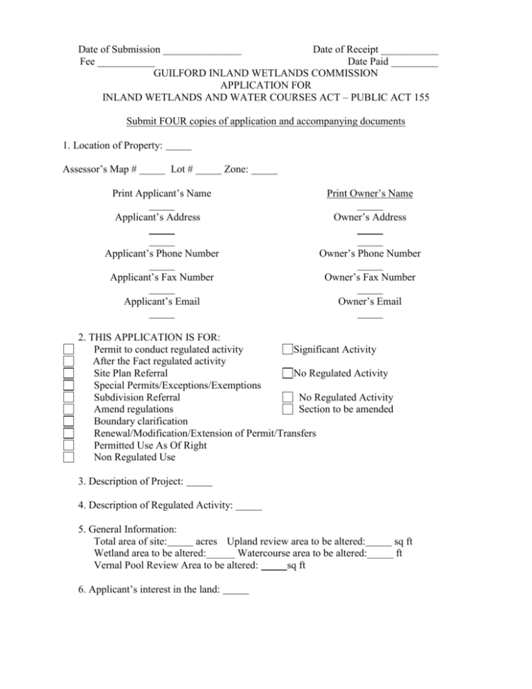
Date of Submission _______________ Date of Receipt ___________ Fee ___________ Date Paid _________ GUILFORD INLAND WETLANDS COMMISSION APPLICATION FOR INLAND WETLANDS AND WATER COURSES ACT – PUBLIC ACT 155 Submit FOUR copies of application and accompanying documents 1. Location of Property: Assessor’s Map # Lot # Zone: Print Applicant’s Name Applicant’s Address Print Owner’s Name Owner’s Address Applicant’s Phone Number Owner’s Phone Number Applicant’s Fax Number Owner’s Fax Number Applicant’s Email Owner’s Email 2. THIS APPLICATION IS FOR: Permit to conduct regulated activity Significant Activity After the Fact regulated activity Site Plan Referral No Regulated Activity Special Permits/Exceptions/Exemptions Subdivision Referral No Regulated Activity Amend regulations Section to be amended Boundary clarification Renewal/Modification/Extension of Permit/Transfers Permitted Use As Of Right Non Regulated Use 3. Description of Project: 4. Description of Regulated Activity: 5. General Information: Total area of site: acres Upland review area to be altered: Wetland area to be altered: Watercourse area to be altered: Vernal Pool Review Area to be altered: sq ft 6. Applicant’s interest in the land: sq ft ft 7. Additional Information: All of the following may require notification or application for permit to other municipal, state, and/or federal agencies. This is the sole responsibility of the applicant or agent. Check those that apply: Any portion the property on which the regulated activity is proposed is located within five hundred (500) feet of an adjoining municipality; or traffic, sewer, water runoff and/or water drainage will impact an adjoining municipality. (See Section 7.6 of the regulations) The property is within a water company watershed or aquifer protection zone and a copy of the letter notifying the proper water company of the application is enclosed. The property is within a floodplain or floodway The property contains tidal wetlands regulated by the CT DEP (See Section 5 of the regulations) The property contains rivers or watercourses regulated by the Army Corps of Engineers The property contains conservation restriction and/or preservation restriction 8. This application shall also include: A map showing: geographical location of the property; inland wetlands and watercourses boundaries marked with flag numbers; areas of wetlands and watercourses and upland review area disturbances; soil types; and vegetation. (see attached checklist) A site plan showing existing and proposed conditions in relation to wetlands and watercourses. (see attached checklist) Alternatives considered and reasons why the proposed activity was chosen. Names and addresses of adjacent property owners Any other information the Commission deems necessary to the understanding of the proposed activity. If the proposed activity involves a significant activity, additional information may be required. (See Section 7.5 of the regulations) This application gives the Commission and its agents authority to inspect the property at reasonable times, both before and after a final decision has been issued. The applicant warrants the truth of all statements contained herein and in all supporting documents according to the best of his/her knowledge and belief. Page 2 of 6 Revised February 23, 2010 The applicant understands that this application is to be considered complete only when all information and documents required by the Guilford Inland Wetlands Commission have been submitted. ____________________________________ Applicant’s Signature & Date ____________________________________ Owner’s Signature & Date Please attach a sheet listing any and all additional property owners and letters of authorization from each. Sheet attached with additional property owners Letter(s) of authorization from additional property owners attached Contact person/agent other than applicant: Contact Person’s Address: Phone Number: Email: Fax Number: Page 3 of 6 Revised February 23, 2010 Site Plan and Environmental Information The applicant shall submit a map or maps and such information concerning the proposed regulated activity(ies) as the Guilford Inland Wetlands Commission indicates below: 1. Sheet Sizes A. B. 8.5” x 11” or multiples thereof 24” x 36” or multiples thereof 2. Graphic scale for site plan information A. B. C. D. 3. Regulated area Area directly involved in regulated activity Property boundaries Additional Area _______’ in diameter Scale Suggested 1” = 40’ Information required Outside regulated area (List) 1” = 40’ 1” = 200’ min 1” = 200’ min North Arrow 4. Title block in lower right corner of sheet showing: A. B. C. D. E. Name of Project Name of owner / applicant and / or developer Date and subsequent date of revisions Legible signature of person responsible for drawing plan. Professional’s certification of the plan shall be appropriate to nature of activities proposed. Such site information about the proposed uses or effect of the regulated area must be certified by a licensed land surveyor, professional engineer, professional architect, or professional landscape architect; any of which must be registered in the State of Connecticut. Any proposed on-site sewage disposal system shall be certified by a registered sanitary engineer. 5. Inland wetland and watercourse boundaries marked with flag numbers, as defined in Section 2 of these regulations, and in Section 4 of Public Act 155. 6. Boundaries and symbol of soil mapping unit (s). 7. Site areas of permit and designation of each activity. 8. Existing and proposed buildings or other structures. A. Location B. Floor elevation Page 4 of 6 Revised February 23, 2010 9. Location, size and composition of sidewalks, off-street parking and loading areas, including driveway entrances and exits, traffic islands and barriers. A. Percent of regulated area to be covered with impermeable surface. 10. Location of tree islands, shrubs and other significant vegetation, both existing and proposed. 11. Source of water supply. 12. Proposed method of sewage disposal. Proposed design and specifications of on-site sewage disposal system certified by a sanitary engineer. 13. Design of existing and proposed storm drainage system including elevations by contour at not less than five foot intervals. Additional details may be required. 14. Proposed grading by not less than five foot contours of any material to be moved. Additional details may be required. 15. Location of all percolation pits, test pits and observation holes and wells. 16. Physical Data A. Material to be deposited and / or excavated 1. 2. 3. 4. 5. 6. 7. 8. 9. 17. Area Volume Physical composition (texture, components) of material to be deposited Chemical composition of all toxic materials Potential chemical reactions of deposited materials yielding toxic products or concentrations of products Final height of filled area above seasonal high water table Texture and composition of soil left after excavation Slope of excavation Depth to water table or water level if inundated after excavation Watercourse Data A. Open water characteristics I. Size of ponds or lakes II. Depth and, if possible, volume of water B. Stream characteristics I. intermittent or continual flow C. D. Vernal Pools Known flood levels to be indicated on map Page 5 of 6 Revised February 23, 2010 18. E. Discharges, if any. I. Type II. Frequency and volume III. Chemical composition F. Creation of new water bodies Biological Data % of Regulated Area A. B. C. D. E. F. Dominant Species Trees Shrubs Grasses, weeds, etc. Aquatic Pasture Cultivated Area 19. Probable effects of changes on: A. Vegetation B. Wildlife 20. Measures to protect regulated area from: A. Erosion and sedimentation B. Leaching and pollutants C. Direct discharge of pollutants D. Increased flooding and surface runoff hazards 21. Other site information as the Guilford Inland Wetlands Commission determines necessary to meet the objectives of the Regulations and Public Act 155. (List) 22. Proposed Planting Plan A. Disturbed Wetlands / Buffer Area B. Grading Plan / Erosion Control Planting C. Type and number of plants proposed 1. Time proposed to ensure survival of plantings 23. Location of erosion control measures / silt fencing / hay bales. 24. Proposed wetland(s) mitigation plan(s). Page 6 of 6 Revised February 23, 2010


