Population Distribution and Climate Module 3 Lesson 3
advertisement
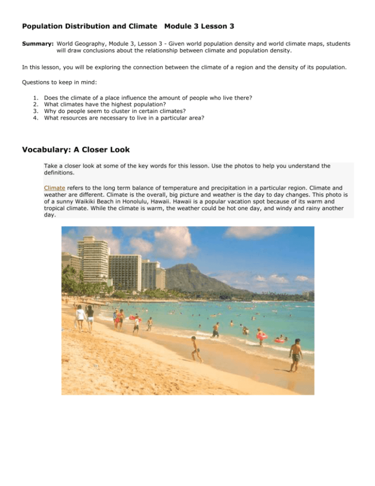
Population Distribution and Climate Module 3 Lesson 3 Summary: World Geography, Module 3, Lesson 3 - Given world population density and world climate maps, students will draw conclusions about the relationship between climate and population density. In this lesson, you will be exploring the connection between the climate of a region and the density of its population. Questions to keep in mind: 1. 2. 3. 4. Does the climate of a place influence the amount of people who live there? What climates have the highest population? Why do people seem to cluster in certain climates? What resources are necessary to live in a particular area? Vocabulary: A Closer Look Take a closer look at some of the key words for this lesson. Use the photos to help you understand the definitions. Climate refers to the long term balance of temperature and precipitation in a particular region. Climate and weather are different. Climate is the overall, big picture and weather is the day to day changes. This photo is of a sunny Waikiki Beach in Honolulu, Hawaii. Hawaii is a popular vacation spot because of its warm and tropical climate. While the climate is warm, the weather could be hot one day, and windy and rainy another day. When you think of population density you should think of how crowded a place is. Population density is actually a measurement of how many people live within one square mile. The photo below is of a typical day in New York City, one of the most populous cities in the world. Notice that the people outnumber the many modes of transportation on the street. New York City has a humid subtropical climate, which means it has hot, humid summers and cold winters. Because New York City generally has all four seasons, many people are attracted to the area. Here's a helpful way to remember Population Density: Less people per square mile = Lower population density & More people per square mile = Higher population density A resource can be defined as anything useful to humans to produce needs and wants. A renewable resource is a resource, such as water, metal, or wood that can be regenerated; it is a resource that can be recycled and used again. Water is a precious renewable resource; it can be filtered, cleaned and reused. The recycle bins in the photo above are examples of how society has become more aware of how important renewable resources are to our environment and how everyone can participate in recycling. In this photo, each bin recycles a specific item (from left to right) glass bottles, plastic bottles, newspapers and magazines, and aluminum cans. Opposite from a renewable resource, a non-renewable resource is a resource that cannot be regenerated, recycled, and reused. Coal is natural resource that is non-renewable; once it is burned, it's gone- well, it takes millions of years to form, so it can be called non- renewable for human use. The photo above is of a common occurrence, it is a photo of a car's exhaust. Just as in coal, oil becomes nonrenewable once it is burned for heat or light. Once made into gasoline and burned in cars, it cannot be recycled or reused. Oil also takes millions of years to form under Earth's surface. The Five Main Climate Zones Tropical Zone – Areas that are warm year round and enough rainfall to support lush vegetation. This is a photo of Molokai, Hawaii. This is an example of a Tropical Climate; notice the lush vegetation next to the ocean. Many vacation spots are in tropical zones for the year round climate Dry Zone – Areas that receive little rainfall and do not support much vegetation. Dry Zones can be warm or cold year round or a combination of both. This is a photo of The Painted Desert in Arizona. Deserts are found in Dry Zones. Moderate Zone –Areas that have mild temperatures year round and enough rainfall to support vegetation. This is a photo of Mulberry River in Arkansas. While there are many locations in the moderate zones, this photo is a great example of how vegetation flourishes in a mild climate and enough rainfall. Continental Zone – Areas that have warm summers, but cold winters. Rainfall does support vegetation, but it is frozen as it snow during winter months. This is a photo of Door County, Wisconsin. The varying colors of the leaves are evidence of the changing seasons. The vegetation seems to represent the change to colder temperatures. Polar Zone – Areas with cool to freezing temperatures all year. These zones can only support hearty vegetation, if any. This is a photo of Barter Island along the northern coast of Alaska. It is used as a radar station for the United States Air Force. The cold conditions and lack of vegetation are perfect for monitoring the radar systems without interference. Photo: Photo: Photo: Photo: Photo: Molokai, Hawaii, Wikimedia. The Painted Desert, Arizona, Wikimedia. Mulberry River in Arkansas; Wikimedia. Door County, Wisconsin, Wikimedia. Barter Island in Alaska, Wikimedia. Comparison Activity: Climate & Population Density To complete this section you will need to closely examine the two maps below (Climate Zones of Earth and Historical Population Density). While studying these maps, consider which climate you think may not attract many people to live and which climates many people would not find attractive for living. Why do you think this is so? Helpful information to help you make your comparison: The least populated areas on Earth are deserts and extremely cold climate zones. Now, look at the Population Density Map, is the first statement true? Source: Map, Human Population Density-1994, U.S. Department of Agriculture Remember The pink areas are the most densely populated. The dark red, red, and orange areas are also very dense with people. Helpful Information to help you make your comparison: Notice that people are not evenly distributed across the land on Earth. The vast majority of Earth's population lives north of the Equator (black line). Most people on Earth live between 20 and 60 degrees north of the Equator (in brackets). In general, people live closer to plentiful resources. Population Density and Resources You will now analyze how the use of renewable and non-renewable resources compares to population density. Take a look at the Historical Population Density Map and decide which areas of the world would use more resources. Source: Map, Human Population Density, 1994, US, Department of Agriculture Remember The pink areas are the most densely populated. The dark red, red, and orange areas are also very dense with people. Helpful Information to help you make your comparison: The more people in an area, the more resources are used. Water is an important renewable resource; people use it to cook, clean, drink and even generate hydroelectricity. Oil is an important non-renewable resource used to run automobiles, various machines, and burn for heat among other uses. Activity Directions: After comparing the map to your knowledge of resources, answer the following questions by clicking on the box that represents the correct area. 1. Which area would use more oil for heat, Area 1 or 2? Area 1 is incorrect because there is a much lower population density, so they would use less oil. Area 2 is correct! This area has a high population density, so they would use more oil. 2. Which area would need more water to support the needs of its people, Area 3 or 4? Area 3 is correct! There is a higher population, so more need for water to support life. Area 4 is incorrect because there is a lower population to support, so less need for water. Study the 5 Main Climate Zones and the Climate Zones of Earth map. Identify which climate zone you live in. Write a list of 3 benefits and 3 challenges you experience because of the climate you live in. Then imagine you had to move into a different climate zone. Which one would you choose? Include examples of renewable and non-renewable resources that you believe would be used in that zone (one of each). Write a paragraph about why you chose that climate zone. Additional Resources Please note that the resources open in a new window/tab in your browser. To return to this lesson, close the additional resource window/tab. Climate Click on this video link to explore the wide variety of climate zones on Earth. Climate Zone Extravaganza Click on this video link to get a basic explanation of tropic, temperate, and polar climate zones.
