Depositional landforms
advertisement
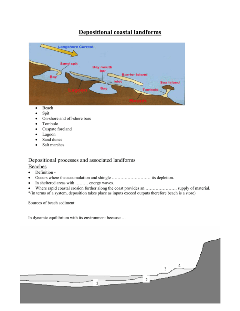
Depositional coastal landforms Beach Spit On-shore and off-shore bars Tombolo Cuspate foreland Lagoon Sand dunes Salt marshes Depositional processes and associated landforms Beaches Definition Occurs where the accumulation and shingle ……………………… its depletion. In sheltered areas with ……… energy waves. Where rapid coastal erosion further along the coast provides an …………………. supply of material. *(in terms of a system, deposition takes place as inputs exceed outputs therefore beach is a store) Sources of beach sediment: In dynamic equilibrium with its environment because … 3 1 2 4 1 = breakpoint bars : 2 = ridges and runnels: 3 = beach face : 4 = berm : The difference between wide and relatively flat beaches and narrow and steep depends upon: Wave energy Particle size Summary: Destructive waves carry material ……….. beach Constructive waves carry material ……….. beach Material is carried upwards on shingle Material is carried downwards on sandy Therefore as destructive waves occur on shingle beaches the movement of beach material will, under normal conditions be evened out. The beach system is in long term equilibrium Spit e.g. Spurn Head What are they? Long narrow ridges of sand and shingle projecting from the coastline into the sea One end joined to the mainland (other end out to sea or part way across a river estuary) Created by: • Prevailing wind and longshore drift • Sand deposited behind a protruding headland (calmer waters) • River brings mud into the calmer waters behind the spit forms salt marsh • A change in prevailing wind direction often causes the end of spits to become hooked (Recurved lateral) • On the spit itself, sand dunes and vegetation; golf courses, holiday parks, beaches • Spits continue to grow until river impedes deposition Sandy spits: constructive waves produced by swell Shingle spits: destructive waves from sea Composite spits: larger sized shingle deposited before the finer sands Bars e.g. Deben estuary, Suffolk Bars: Created where a spit grows across a bay, joining two headlands. Definition: “When a spit extends across a bay linking two headlands, straightening the coastline” e.g. Deben estuary, Suffolk. Off-shore bar: accumulates below the low tide mark and moves progressively inland. The relatively shallow water generates constructive waves which transport material landwards creating a long smooth coastal feature topped by sand dunes. Offshore Bars are also known as Barrier Beaches – these are ridges of shingle and sand which are parallel to the coastline and unattached to it A narrow and long landform that extends into a body of water which forms from deposited sediment. – Appears in rivers, lakes and seas – Normally formed from sand. However can include soil, silt, gravel, cobble, shingle, boulder, etc. – Deposition occurs due to moving water – Grain size relative to strength of moving water Types of bars: • Sandbars/Longshore Bars: – Forms at breaking point of waves – Sand which is carried by bottom current is deposited where the waves break • Harbour/River Bars: – Bars formed from deposition at the harbour entrance or river mouth – Can be troublesome and even dangerous obstacles: • Causes floods • Prevents movement of ships/boats • Behind the bar, a lagoon is created, where water has been trapped and the lagoon may gradually be filled as a salt marsh develops due to it being a low energy zone, which encourages deposition Lagoon e.g. Dee Why Lagoon (separated from the Tasman Sea by the tombolo of Long Reef), suburban Sydney, Australia Lagoon - A shallow body of salt water close to the sea but separated from it by a narrow strip of land, such as a barrier island, or by a coral reef. These bodies of water were formally part of the sea but have been ‘cut off’ through depositional processes e.g. bars or tombolos may create lagoons in the process of their formation. Tombolos e.g. Chesil Beach, Dorset Definition: “When a spit or bar joins the mainland to an island” e.g. Chesil beach, Dorset (30km long, 14m high due to prevailing winds of English Channel. Links Isle of Portland to the mainland) Tombolos and wave refraction: Island bends incoming waves, which curve around it and meet behind, sweeping and depositing sediment behind the island • Tombolos can also form as a result of longshore drift - a spit continues to grow outwards joining land to an offshore island Cuspate foreland e.g. Dungeness, S.E.England Complex depositional features formed when longshore drift from 2 opposite directions meets to produce series of ridges at right angles to each other, e.g. Dungeness, S.E.England 2000 years ago, when the sea level in SE England was 2m lower, the coastline was 15km inland. With predominant winds and the fetch of over 5000km both from the southwest beach material is usually carried by longshore drift from west to east along channel coast. However, some of the fiercest storms are when the wind blows from the northeast, and, although the second greatest fetch is only 600km, during these storms much shingle is carried east to west. The 2 sets of storm waves have built up a series of shingle ridges, each newer ridge protecting the one behind it. Salt marshes Vegetated intertidal mud or sand flat Found in flat, protected waters Healthy marsh: maintains a delicate balance between salt water and fresh water Protected waters- within the protection of a barrier, estuary, or low energy coastline Healthy marsh: maintains a delicate balance between salt water and fresh water, especially further inland where a salt marsh may merge with a brackish area or a freshwater swamp. Formation: Incoming tides carry and deposit sediment across low-lying land Rivers transport sediments and nutrients necessary Saltwater grasses then slowly take hold and spread As the plants decay and sediment builds up, peat deposits accumulate Grasses stabilizing the land through the growth of root systems Rivers and other upland sources contribute sediments to the marsh continually Zones of a saltmarsh: Closer to the shoreline, the daily tides creates zones: The Lower Marsh The Higher Marsh The Salt Pans The highest edges The Lower Marsh is often submerged under saltwater, and supports the growth of organisms adapted to high salinity and lots of moisture. The Upper Marsh is a drier area, where plants tolerate lower salt concentrations. The salt pans are small depressions that trap and hold water on a high tide. The highest edges of the marsh are only reached by extremely high tides, such as during a storm. Disappearance of salt marshes: • Drained or filled to build housing, factories, roads, or as mosquito control • Used as garbage dumps. • Extremely vulnerable to pollution buildup because of the way particles are re-circulated within the marsh • Plants and animals cannot survive in such a harmful environment • The marsh, which takes hundreds of years to form, is easily threatened and lost within just a few decades Sand dunes • • • • • • • • • • • • • • • • A dune is a hill of sand built by aeolian processes (*aeolian: processes pertain to the activity of the winds) Dunes also form under the action of water flow (alluvial processes), on sand or gravel beds of rivers, estuaries and the sea-bed. They are dynamic landforms – theychange all the time, particularly during the early formation stages. When they are more established and bound by vegetation, sand dunes are much more stable and tend to ‘stay put’. Constructive waves encourage build-up of sand Prevailing onshore winds blow this sand inland Obstacles needed e.g. vegetation, pebbles etc. to trap the moving sand grains. Sand grains get trapped Start to accumulate Voila this is the start of dune formation! Wind affects the mound of sand -> eroding sand particles from the windward side + depositing on the leeward side. Over time this action causes the dune to “migrate” inland and as it does so it accumulates more + more sand. Forms and sizes based on interaction with the wind. Most kinds of dune are longer on the windward side where the sand is pushed up the dune, and a shorter "slip face" in the lee of the wind. Sand dunes are accumulations of sand shaped into mounds by the wind. They represent a dynamic landform. Beaches are the source of the sand, which, when dried out, is blown inland to form dunes. Sand is moved inland by a process known as saltation. This is when sand dunes begin to build up.
