Nepal_shelter_vulnerabilities_assessment_ToR
advertisement
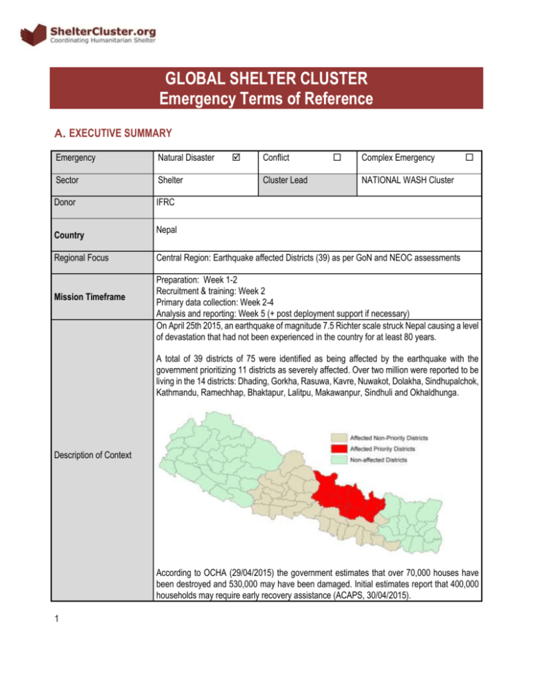
GLOBAL SHELTER CLUSTER Emergency Terms of Reference A. EXECUTIVE SUMMARY Emergency Natural Disaster Sector Shelter Donor IFRC Country Regional Focus Mission Timeframe Conflict Cluster Lead Complex Emergency NATIONAL WASH Cluster Nepal Central Region: Earthquake affected Districts (39) as per GoN and NEOC assessments Preparation: Week 1-2 Recruitment & training: Week 2 Primary data collection: Week 2-4 Analysis and reporting: Week 5 (+ post deployment support if necessary) On April 25th 2015, an earthquake of magnitude 7.5 Richter scale struck Nepal causing a level of devastation that had not been experienced in the country for at least 80 years. A total of 39 districts of 75 were identified as being affected by the earthquake with the government prioritizing 11 districts as severely affected. Over two million were reported to be living in the 14 districts: Dhading, Gorkha, Rasuwa, Kavre, Nuwakot, Dolakha, Sindhupalchok, Kathmandu, Ramechhap, Bhaktapur, Lalitpu, Makawanpur, Sindhuli and Okhaldhunga. Description of Context According to OCHA (29/04/2015) the government estimates that over 70,000 houses have been destroyed and 530,000 may have been damaged. Initial estimates report that 400,000 households may require early recovery assistance (ACAPS, 30/04/2015). 1 Main objective Specific objectives Data Sources Targeting Period of field assessment REACH Resources Expected Results Expected Deliverables To inform operational and strategic planning for life saving and recovery activities regarding shelter and to provide a shelter baseline for a longitudinal analysis of the recovery process of those affected by the earthquake 1. To verify emergency shelter & NFI coverage assumptions and gap analysis 2. To enable the shelter cluster to define a comprehensive shelter & settlements recovery strategy 3. Establish a baseline and method for longitudinal study of recovery PRIMARY DATA COLLECTION: Household level Interviews at district level. SECONDARY DATA COLLECTION: OCHA, IFRC, NEOC, GoN census data, ACAPs and humanitarian actors 14 districts in the central region of Nepal in earthquake affected areas using a representative sample (95% confidence with a 10% margin of error) at the household level. A minimum of 10 households will be conducted per VDC allowing for 12 VDCs to be assessed per district. By the 25th of May, REACH shall provide deliverables for 14 districts across the affected areas included in the initial assessment. May 9th to May 20th conducted by the REACH team supported by the Centre for Disaster management volunteers. 2 x Assessment Specialist (International) 1 x GIS Officer (International) Pending discussions for national employment based on financial resources 1. Collection and collation of secondary data (OCHA, IFRC, NEOC, GoN census data, ACAPs and humanitarian actors); 2. A representative random sample of affected households in the priority districts 14 earthquake affected districts 3. Detailed information regarding shelter needs and vulnerabilities amongst affected households is analysed and mapped. 1. Interim assessment report (May 25th) 2. Final assessment report (End of assessment) 3. District profiles analysed in conjunction with ACAPS pre-quake profiles. 4. Summary Data Tables / queries using primary data 5. Static maps created using secondary and primary data 6. Database available at Shelter Cluster level (uploaded to Humanitarian Data Exchange Nepal page) B. OBJECTIVES OF THE ASSESSMENT To inform operational and strategic planning for life saving and recovery activities regarding shelter and to provide a shelter baseline for a longitudinal analysis of the recovery process of those affected by the earthquake B.1. Specific Objectives The objectives of the rapid assessment will be: 1. To verify emergency shelter & NFI coverage assumptions and gap analysis 2. To enable the shelter cluster to define a comprehensive shelter & settlements recovery strategy 3. Establish a baseline and method for longitudinal study of recovery C. METHODOLOGY Two sources of data will be used: Field data collection (Household level interviews) and secondary data. The figure below outlines the tools to be used and the data expected from each technique: Secondary Data: Sources will include: OCHA, IFRC, NEOC, GoN census data, ACAPs and humanitarian actors Field Data Collection: focused on collecting thematic data from the field through georeferenced Household Interviews sampled per district. Prior to the launch of primary data collection, REACH, in cooperation with Global Shelter Cluster representatives, will conduct a thorough secondary data review to identify information gaps in the target areas with regards to shelter vulnerability. Secondary data will be collected through the Shelter cluster, OCHA coordinated assessment coordination and Government of Nepal. Secondary data will be used to validate data collected by enumerators in the field. Based on the secondary data review, REACH will design a household level assessment to be utilised during the primary data collection phase. In addition to informing tool design, secondary data will be utilised to validate data collected by enumerators in the field. 30 enumerators, divided into XX teams of XX, will deployed in each targeted district to conduct randomly samples household interviews in accessible areas of the VDCs within selected districts. Household assessments will be conducted with a data collection tool built on the Android smartphone based Open Data Kit (ODK) platform. Data collected in the field will be validated by the team leader before being updated to the central database, after which a final data quality check will be conducted by the REACH Assessment Specialist. Household assessment will be collected to a consistent statistical significance a district level to allow for cross district comparisons (see annex 1 for household target areas). In non-accessible areas key informants will be used (XX per non-accessible VDC) as household assessments will not be possible. Designed to serve as a baseline, the household assessments is expected to ascertain whether availability of services, materials, facilities, infrastructure & habitability have improved or have been restored from/to the pre-crisis situation 25th March initial earthquake. C.1. Sampling Strategy This assessment will use multi-stage cluster sampling in order to give a complete picture of the situation in the aftermath of the earthquake. Stage 1: Selection of target districts This assessment will target all 14 priority districts of the 39 affected districts by the earthquake. A statistical significant assessment of 95% confidence level and 10% margin of error will be conducted across each district. Based on government population data, VCDs within each district will be weighted and randomly sampled with a minimum of 10 households per district. This will therefore cover a minimum of 12 VCDs per each of the assessed district. There will be slight oversampled to account of poor records that will be excluded during the data cleaning process. Further stratification will happen in very difficult to access areas across Gorkha, Dhading, Rasuwa and Sindupalchok based on the topographical boundaries of the valley. In these areas sampled assessments (or key informant interviews) within a 1.5km buffer of the valley bottom will happen throughout the valleys as the response will be dictated by the natural topography of the landscape. Stage 2: Random selection of households VCDs within selected districts will be weighted on population size and randomly selected for the assessment, with more densely populated VCDs more likely to be selected but with less populated VCDs also represented, it is for this reason that the minimum amount of target households per district is 10 rather than a higher number. Stage 3: Random selected households within selected VCDs A cluster of 10 households will be assessed randomly in each VCD targeted for the assessment. Need to figure this bit out. C.2. Target Locations The Shelter Cluster strategy has decided to focus primarily on the primary affected areas due to preliminary assessments indicating high levels of shelter and infrastructure damage. As per the sampling methodology above, these 14 districts will be the sole geographic area targeted for assessment, however, as and when further needs are assessed and other critical locations are identified, the areas targeted for assessment may be amended. Map of selected districts here C.3. Preliminary Work Plan Activities A.1. Arrival and collection of initial secondary data & methodology design A.2. Recruitment and training of enumerators A.3. Field Data Collection A.4. Analysis and Map production A.5. Preliminary results workshop A.6. Preliminary Results dissemination A.7 Data validation A.8 Final Results dissemination 1 2 May 3 4 5 C.4. Data Collection Coordination REACH hubs based on Dhading, Kathmandu and Sindhupalchock will be responsible for coordinating the data collection activities across the 14 districts. Each hub will be staffed by an REACH assessment specialist supported with national field coordinators. The field coordinators will be responsible for all daily field operations and field data collection. The REACH Assessment Specialist will be responsible for management of the entire assessment as well as coordination with the Shelter Cluster and other stakeholders. Field data collection will be conducted using locally recruited staff specifically for the assessment. Enumerators, and their team leaders, will be expected (where necessary) to stay overnight in or near the targeted districts for the assessment until all data has been collected; to facilitate this, accommodation will be sought by REACH. Vehicles for transportation will be either procured by REACH through rental agreements, or a fuel stipend will be provided to enumerators for the use of their own vehicles. Where enumerators and drivers are recruited specifically for the assessment, REACH will facilitate the payment of daily salaries. Due to difficulties in a) obtaining drivers willing to drive around the affected areas and b) accessing some areas using cars, REACH will provide enumerators will a stipend to rent motorcycles on a daily basis, when necessary. Air transportation will be taken into consideration too when logistically possible as well as travelling by foot in difficult to access areas. On a daily basis, the field coordinators will provide the enumeration teams with a list of target districts and the sub VCDs / municipalities with the number of target household interviews required per administration unit. In addition, maps of the target locations, including detailed road data (status also if possible), will be prepared in order to facilitate data collection. Upon arrival in a District or a VCD/Municipality, the team leader will be responsible for introducing Chief District Officer (CDO) and VDC officials to the objectives of the assessment to ensure local acceptance. The ODK (Open Data Kit) platform significantly improves data quality as a result of: Reducing human error as a result of loss of forms, data collection mistakes, and data entry mistakes thus improving the accuracy of collected data and thus rapidity of data upload. Increases the speed at which mapping products and analytical reports can be produced through reducing data cleaning time and removing the for data entry; Ensuring the protection of data as a result of completed forms being removed from the data collection tool upon upload to the centralised database. C.5. Data Entry & Analysis The Shelter and Settlements assessment will focus on three primary areas of analysis: Pre-crisis shelter situation; Immediate post-crisis situation (i.e. adequacy of emergency shelter interventions in facilitating self / early recovery). Establish a baseline and method for longitudinal study of recovery over the next 12 months At a interim-point in the assessment (May 20th), REACH will hold a preliminary analysis workshop with shelter cluster partners and other relevant actors (including the Government of Nepal relevant focal point). C.6. Information products / outputs Following the conclusion of data collection and cleaning the following deliverables will be produced by REACH (in close cooperation with Shelter cluster partners); Cleaned dataset – uploaded to Humanitarian Data Exchange Interim Assessment Report (due May 20th) Final Assessment Report (incl. recommendations for ongoing monitoring by shelter cluster partners) Individual District Profiles Thematic static maps displaying primary data and secondary data Draft tools for monitoring impact of shelter cluster interventions based on REACH baseline D. RESOURCES PLAN AND OPERATIONS (BUDGET BREAKDOWN) Pending disucussions ANNEX 1: TABLE OF AFFECTED DISTRICTS District Arghakhanchi Baglung Bara Bhaktapur Chitawan Dhading Dhanusa Dolakha Gorkha Gulmi Kapilbastu Kaski Kathmandu Kavrepalanchok Lalitpur Lamjung Mahottari Makwanpur Manang Mustang Myagdi Nawalparasi Nuwakot Okhaldhunga Palpa Parbat Parsa Pyuthan Ramechhap # of VDCs/Municipalities per district 42 60 99 18 39 50 102 52 67 79 78 45 59 90 42 61 77 44 13 16 41 75 62 56 66 55 84 49 55 Rasuwa Rautahat Rupandehi Saptari Sarlahi Sindhuli Sindhupalchok Siraha Syangja Tanahu 18 97 72 116 100 54 79 108 62 47
