Eng Comments - Jefferson County Government
MEMORANDUM
TO : Alan Tiefenbach, Case Manager
FROM : Nathan Seymour, Planning Engineering
DATE : June 26, 2015
RE : 15-112307PA; Pre-Application Rezoning and SDP at 31033 American Parkway
These comments have been based upon the application package and the requirements of the Jefferson
County Land Development Regulation (LDR), the Jefferson County Zoning Resolution (ZR), the Jefferson
County Storm Drainage Design and Technical Criteria (Storm Drainage Criteria) and the Jefferson County
Roadway Design Manual (Roadway Manual).
REZONING COMMENTS
1. Official Development Plan (ODP) - Written Restrictions: The written restrictions were not provided.
When prepared, the ODP should not conflict with the requirements of the LDR.
2. Official Development Plan (ODP) - Graphic Portion: The graphic portion was not provided. When prepared, the ODP should not conflict with the requirements of the LDR. Streets/Driveways and access connections to the existing streets/driveways should not be shown on the ODP unless a provision is added indicating that the streets/driveways and the intersections are conceptual only and have not received County approval. Classification, alignment, width, intersection location, turning movements, and design and construction standards shall be in accordance with the LDR and be determined during the plat process.
3. Soils – Geohazard Area: This site, or a portion of this site, is in a zoned geologic hazard area.
Because of the potential for land subsidence, it is recommended that no portion of the proposed lots be within the zoned geologic hazard area. If any portion of the lots are proposed within the zoned geologic hazard area, the applicant will need to submit a geologic/geotechnical report that studies the feasibility of and methods for developing within the geologic hazard area. The report needs to provide a finite element analysis of the subsidence area and needs to show where the zero subsidence line occurs, including a factor of safety to ensure stable development. The report also needs to be reviewed and approved by the Colorado Geological Survey.
4. Site Development Plan: The applicant needs to be aware that prior to the issuance of a building permit, a Site Development Plan Approval is required; please see the Zoning Resolution, Section 1.I for more detail on the requirements for the Site Development Plan.
SITE DEVELOPMENT PLAN COMMENTS
SITE DEVELOPMENT PLAN DOCUMENT
As a final concept site plan was not provided, the Site Development Comments provided are general in nature and are subject to change based on the submittal information provided at the time of the SDP.
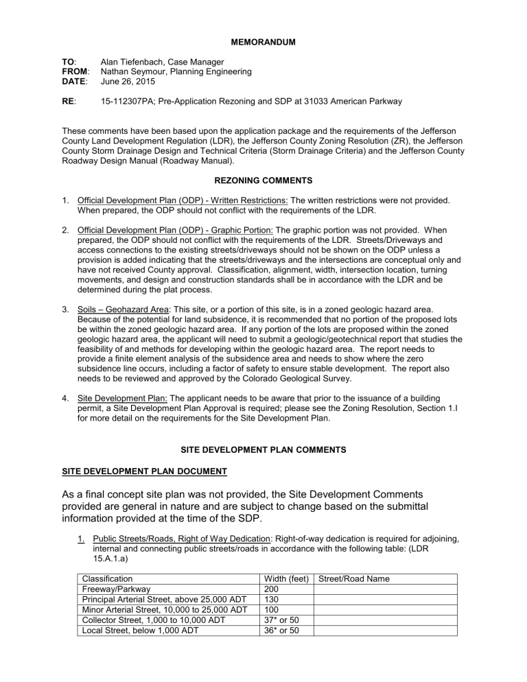
1. Public Streets/Roads, Right of Way Dedication: Right-of-way dedication is required for adjoining, internal and connecting public streets/roads in accordance with the following table: (LDR
15.A.1.a)
Classification
Freeway/Parkway
Width (feet) Street/Road Name
200
Principal Arterial Street, above 25,000 ADT 130
Minor Arterial Street, 10,000 to 25,000 ADT 100
Collector Street, 1,000 to 10,000 ADT
Local Street, below 1,000 ADT
37* or 50
36* or 50
Alan Tiefenbach
Page 2 of 7
Principal Arterial Road
Minor Arterial Road
Collector Road, above 1,000 ADT
Local Road, below 1,000 ADT
Cul-de-sac turn-around
100
70
50
50
45 radius
Evergreen Pkwy Access RD
* For templates with detached sidewalks only additional sidewalk sign and maintenance easements are required. a. Adjoining Right-of-Way: This project adjoins Evergreen Pkwy Access RD. Evergreen Pkwy
Access RD is classified as a Collector road due to traffic volume. Dedication of right-of-way will be required adjoining the subject property measured 25 feet on either side from the centerline of the street/road if not previously dedicated. The centerline of the existing street/road and proposed right-of-way or the boundaries and recording information of previously dedicated rightof-way shall be shown. (LDR Section 15.A.1.a(1) and LDR Section 15.A.1.a(4)) b. Additional Right-of-Way: Additional right-of-way may be required for acceleration/deceleration lanes and for left-turn lane improvements, roundabouts, interchanges, medians or any other improvements required by the Land Development Regulation LDR Section 15.A.1.a(4). c. Existing Right-of-Way: Previously dedicated rights-of-way shall be shown, with the book and page or reception numbers of the recorded deeds noted. If right-of-way for [street/road name]adjoining this property has not been dedicated, this information shall be noted on the survey. (LDR Section
8.D.9)
2. Private Street/Road Easements: Dedication of an emergency access easement across the interior and exterior private access drives is required. The on-site private access drives shall be a minimum of 25 feet wide and labeled as a “Utility and Drainage Easement and Private Access Drive” (LDR
Section 15.A.1.a.(2)).
3. Public Street/Road Intersections: Property line corners at street intersections shall be rounded at the intersections by a 30-foot radius (LDR Section 15 A.1.a.(5)).
4. Private Street/Road Intersections: Private street easement(s) shall be rounded at the intersection(s) by a 30-foot radius (LDR Section 15 A.1.a.(5)).
5. Non-Buildable Areas: Non-buildable areas should be fully dimensioned and tied to reference points and be shown by a fine, continuous line (LDR Section 8.D.12). Such areas include the proposed
100-year floodplain, areas dee med by the Geologic Report as “non-disturb” or “non-build” and rock outcrops (LDR Section 14.A.2).
6. Drainage Easements: Drainage easements are required to be dedicated to the County and state that the County has the right of access on the easements which shall be kept clear of obstructions to the flow and/or obstructions to maintenance access (Section 3.3.9 of the Jefferson County Storm
Drainage Design and Technical Criteria). Easements shall be dedicated according to the following:
DRAINAGE FACILITY DRAINAGE EASEMENT WIDTH
1. Storm Sewer/Subsurface Groundwater
Collection System Mains /Interceptor
Underdrains
(a) less than 36" dia.
(b) equal to or greater than 36" dia.
2. Open Channel/Swales
(a) Q
100 less than 1 cfs
(b) Q
100
greater than or equal to 1 cfs and less than or equal to 20 cfs
20'
Twice the pipe invert depth with sewer placed within the middle third of the easement
(minimum width = 20')
5’ minimum
15' minimum
Alan Tiefenbach
Page 3 of 7
(b) Q
100
greater than 20 cfs 15' minimum (Must accommodate Q
100
plus one foot of freeboard)
3. Detention/Retention/Water Quality Ponds As required to contain storage and associated facilities plus adequate maintenance access to the pond and around perimeter.
Dedication of easements to the County is required for all pipes, channels, swales and other drainage appurtenances and facilities (including those located on adjoining property).
7. Landscaped Strips: A landscaped strip shall be preserved adjacent to all freeways, arterials and collector streets in accordance with the following: (ZR Section 15.F.1.a)
Street Classification
Freeway
Landscaped Strip Width
30 feet
Street Name
Arterial/Parkway
Collector
20 feet
10 feet Evergreen Pkwy Access Road
8. A copy of the Exhibit "A" subject to the requirements of Section 33 of the LDR should be submitted.
The Exhibit "A" must also include but is not limited to: a. Emergency access gates b. Private streets/roads c. Private street /road connection to (including curb cuts and directional islands) d. Water and sewer facilities. Note: If the water and sanitation district assure the County in writing that it can guarantee the water and sewer system improvements, the plans do not need to be submitted and the water and sewer facilities do not need to be placed on the Exhibi t “A”. e. Drainage improvements f. Any quantities for rotomilling and asphalt patching necessary to make utility connections. {only for asphalted County maintained roads} g. Traffic signs (stop) h. Grading Erosion and Sediment Control
9. Quantities shall be in groups that reference specific street/road names or other identifiable subdivision features. For more Information please see the standard format at http://jeffco.us/jeffco/planning_uploads/apps_handouts/exhibit_a.pdf
10. Separate line item[s] shall identify the quantities and costs for those improvements when the developer will provide cash in lieu of construction.
11. A separate Exhibit “A” for landscaping, if required, needs to be submitted to and be approved by
Planning and Zoning.
ENGINEERING DESIGN STANDARDS
Circulation (Horizontal and Vertical Control)
1. Street Repair After Utility Connections: The applicant will be responsible for guaranteeing and completing any rotomilling and asphalt patching on street/road necessary to complete utility connections. Refer to the Exhibit A comment section for additional information.
Alan Tiefenbach
Page 4 of 7
2. Guardrail Requirements: In locations where guardrail is required for public or private roads, design shall be in accordance with the current American Association of State Highway and Transportation
Officials (AASHTO). Guardrail locations shall be shown on the construction plans. (LDR Section 15
1.b.(1))
3. Private Road Design: Private roads (any access serving more than one lot, existing and proposed, interior and exterior to the development) will need to be constructed to meet the requirements of
Section 3.6.8.2 of the Roadway Manual. Pursuant to LDR Section 15 A.1.b.(2)(c), all private roads within the proposed subdivision shall be paved if the sum of the existing and proposed ADT on the roads exceeds 150. Private road requirements include the following: a. Turnarounds must be provided at the ends of private roads that exceed 150 feet in length.
Additionally, turnouts must be provided every 150 feet along private streets/roads with a total width of less than 20 feet. If the narrower template is used on a corner it is likely widening will be needed on the corner in order for larger vehicles to make the turn. Please see the attached design table for more information. b. *Minimum horizontal curve radius is 30 feet (Section 3.7.8.2.1 of the Roadway Manual). c. Maximum grade shall be in accordance with Section 3.7.8.2.4 of the Roadway Manual. d. Private road width shall be in accordance with Section 3.7.8.2.2 of the Roadway Manual.
* Please be aware that most fire truck’s turning radii varies from 40 to 50 feet. Please check with the Fire Protection District for the latest design vehicle dimensions and turning radius. In most cases, the minimum 30-foot radius will not be adequate for fire trucks, trash trucks and moving trucks. Minimum turning radius for trash trucks and moving trucks are available in Exhibit 2-2 in
AASHTO: a Policy on Geometric Design of Highways and Streets.
The appropriate Fire Protection District may approve alternate standards for private roads in accordance with 3.7.8.3 of the Roadway Manual.
4. Non-Residential Driveway Design: Non-residential driveways will need to be constructed to meet the requirements of Section 3.6.8.2 of the Roadway Manual. The requirements include the following: a. Turnarounds must be provided at the ends of driveways that exceed 150 feet in length. As an alternative to this standard, the applicant can submit written evidence from the governing Fire
Protection District approving the circulation in the parking area. b. Approaches to public streets/roads [and modifications to the private street/road approaches] shall meet the requirements of Standard 9 in the Roadway Manual.
5. Parking Lot Design: All off-street parking and loading must meet the standards in Section 14 of the
Zoning Resolution. The requirements include the following. a. ADA Parking Requirements: Please show the ADA parking spaces on the grading plan. The grading plan also needs to show that the maximum longitudinal slope on the ADA parking spaces is 2%.
b. Parking Setbacks: The grading plan shows parking within the 6 foot parking setback. All parking spaces and loading areas shall be placed a minimum of 6 feet from any property line (Section
14.E.1 Zoning Resolution). c. Parking Lot Paving: All parking and loading facilities in the plains shall be concrete or asphalt and all facilities in the mountains servicing more than 150 trips per 24 hours shall be surfaced with concrete or asphalt (Section 14.E.7.a Zoning Resolution). Please include a typical parking lot paving detail in the plans.
d. Parking Lot Curb and Gutter: Curb and gutter is required for all commercial and industrial parking lots. The concrete curb and gutter shall be placed around the perimeter of the parking lot and around any raised curbs (Section 14.E.8 Zoning Resolution). Please show the curb and gutter on the site plan and grading plan and include a detail of catch and spill curb and gutter on the construction plans.
Alan Tiefenbach
Page 5 of 7 e. Parking Lot Drainage: All parking and loading facilities shall be designed, graded and provided with storm drainage facilities that comply with the most recent Storm Water and Drainage Criteria except that sheet drainage shall not extend 200 feet in the direction of flow. Parking areas wider than 42 feet shall contain some mechanism for concentrated flow of drainage such as cross-pans or storm sewer. Drainage from snow storage, drip lines, sub-drains and sheet flow from areas other than parking shall be diverted away and shall not cross parking areas (Section 14.E.9
Zoning Resolution).
f. Parking Lot Grades: Parking lot grades shall not exceed 6% in any direction (Section 14.E.11
Zoning Resolution). g. Parking Space Delineation: Please include the required signage and surface markings for the
ADA parking in the construction plans. See Section 14.E.14 of the Zoning Resolution for the requirements. h. Parking Lot Stacking: The minimum distance between the parking lot and public street or right of way is 20 feet (Section 14.H Zoning Resolution). Please revise the plans to comply with the minimum stacking distance.
6. Intersection Spacing: Street/Road/Driveway intersections shall meet the spacing requirements of the
Land Development Regulation. In order to determine spacing, the nearest streets, intersections, and driveways, both adjacent and opposite to the proposed development need to be shown on the preliminary/supplemental plat/plan (LDR Section 15 A.1.c. and LDR Section 15 A.2).
7. Stop Sign Control: Stop sign control is required at all unsignalized intersections.
8. Vision Clearance Triangle: Trees, hedges, shrubs, fences, walls and other structures, and facilities and devices over 42 inches in height that would obstruct a driver's vision within the vision clearance triangle of any public street intersection will not be permitted. The triangle is measured from the point of intersection of the right-of-way/easement/lot lines extended. [If there are obstructions in the triangle on the adjoining property, the applicant will need to obtain the necessary rights from that property owner to eliminate the obstructions or the intersection will need to be relocated]. (Section
3.7.2 of the Roadway Manual)
GRADING AND DRAINAGE
1. Grading and Erosion Control Plan Phasing: According to the requirements from the State of Colorado stormwater discharge permit, the grading, erosion and sediment control plan must be phased. The
Grading Erosion and Sediment Control Plan must clearly depict the relationship between the phases of construction and the implementation and maintenance of BMP’s.
2. Grading Setbacks: Setbacks for all grading and erosion control activities shall be at least 7 feet from the property boundaries and at least 25 feet from occupied structures. In order for Planning and
Zoning to waive the setback requirements the applicant must demonstrate either from an approval letter from the adjoining property owner or by an approved geotechnical report that the activities occurring within setback limitations will not adversely affect adjacent property or structures (Section
16.E.10 of the Zoning Resolution).
3. Vertical Disturbance for Private Roadways or Driveways: It may prove difficult for this proposal to comply with the requirement that ground disturbance not exceed 20 feet vertically between the top of cut and toe of fill slopes for the proposed private interior road(s) or driveway. An Administrative
Exception may be requested for an additional 5 vertical feet. If the proposal cannot meet this standard, approval of a variance must be granted by the Board of Adjustment (Section 16.E.9 of the
Zoning Resolution).
4. Geology and Soils: The applicant will need to submit a Soils and Geotechnical Report with the Site
Development Plan application (Section 1.I.3.d(6) of the Zoning Resolution).
Alan Tiefenbach
Page 6 of 7
5. Infiltration Encouraged: Where soil types allow, the County encourages the use of structural BMPs that match the runoff reduction and water quality recommendations of the Urban Drainage 4-step process outlined in UDFCD Volume 3, BMP Planning for New Development, beginning on page ND1.
Step 1 BMPs reduce the required WQCV and there are other BMPs that meet the water quality basin capture volume requirement in addition to the extended detention basin. Reduction in the total required stormwater detention volume is permitted for site that confirm to the criteria in Urban
Drainage for minimizing directly connected impervious area please see Chapter 14 of the Jefferson
County Storm Drainage Design and Technical Criteria for more information.
6. Full Spectrum Detention: In order to minimize damage to downstream properties Full Spectrum
Detention is required for all new detention ponds and regional ponds that will be utilized as part of a development project (Chapter 14.2 of the Drainage Manual). Please see the criteria fir full spectrum detention in the Urban Storm Drainage Criteria Manual Volume II (Storage). A new detention pond design checklist is also available in the appendix of the new Drainage Manual for more information on stormwater detention pond(s) design.
7. Drainage Off-site: It must be demonstrated that the detention pond outfall has a means of draining into an existing drainageway or storm sewer system. In addition, the capacity of the drainageway or storm sewer shall be verified.
8. Drainage Off-site: The County requires that the flow released from the site be channeled (pipe or swale) to an existing drainageway or storm sewer (Section 16.E.11.a of the ZR). If the land(s) between the site and the drainageway or storm sewer is not owned by the applicant, the applicant will need to acquire an easement from the land owner(s) to accommodate the altered discharge of storm drainage flow on adjoining land(s). The easement(s) provides the right to construct and maintain the drainage swale or pipe and associated drainage improvements as required by (Section 3.3.9 of the
Storm Drainage Manual This requirement cannot be deleted or waived by the County. It is essential, that the applicant be aware of this requirement and be able with some certainty to comply with the
County’s requirement to obtain the necessary rights from other property owners as discussed above.
Fire Protection
1. Fire Hydrants (Section 24, LDR): a. Fire Hydrants: Fire hydrants shall be provided when a water distribution system will serve the proposed development (LDR Section 24.A.1.). b. Fire Department Access: All streets and roads, including emergency access, shall be designed and constructed according to Section 3.1 of the County Roadway Design and Construction
Manual (LDR Section 24 A.3.a).
Landscaping
1. Vision Clearance Triangle: Vision clearance triangles, sized according to the Zoning Resolution, must be shown at all intersections on the plan.
Additional Requirements
1. Construction Documents: Construction documents are required for all construction associated with the plat/exemption or site development plan. Please submit all plans and reports in an electronic
PDF format construction plans. The Plans may be either emailed to the case manager or put on a
CD.
2. Fire Wall Verification: The applicant must provide a letter from the building department that indicates that the condo units were constructed with a common wall meeting the requirements of the 2009
International Residential Code
Alan Tiefenbach
Page 7 of 7
3. Private Maintenance Organization: The applicant will be required to establish an organization
(normally a property or homeowners' association) to own and maintain private streets, drainage and detention facilities and common areas unless an existing organization agrees in writing to maintain these improvements.
4. Traffic Impact Fees: LDR Section 33 A.8 requires the payment of TRAFFIC IMPACT FEES when obtaining a building permit on any lot within this development. This development will not be eligible for any credit towards the full amount of the fee.
CONCLUSION
1. These initial case comments are based solely upon the submitted preliminary application package.
They are intended to make the applicant aware of regulatory requirements. Failure by Planning
Engineering to note any specific item does not relieve the applicant from conforming to all County regulations. Furthermore, if the proposed site layout and design are altered substantially during subsequent County land development processes (rezoning, platting, exemptions, additional submittals), Planning Engineering reserves the right to modify these initial comments or add appropriate additional comments.
The applicant should respond to these comments. If there are any questions please contact Nathan
Seymour at 303-271-8751.


