Gravity Waves Make Tornadoes
advertisement
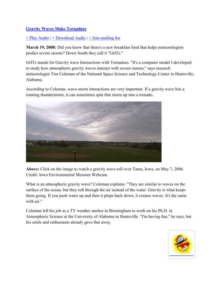
Gravity Waves Make Tornadoes + Play Audio | + Download Audio | + Join mailing list March 19, 2008: Did you know that there's a new breakfast food that helps meteorologists predict severe storms? Down South they call it "GrITs." GrITs stands for Gravity wave Interactions with Tornadoes. "It's a computer model I developed to study how atmospheric gravity waves interact with severe storms," says research meteorologist Tim Coleman of the National Space Science and Technology Center in Huntsville, Alabama. According to Coleman, wave-storm interactions are very important. If a gravity wave hits a rotating thunderstorm, it can sometimes spin that storm up into a tornado. Above: Click on the image to watch a gravity wave roll over Tama, Iowa, on May 7, 2006. Credit: Iowa Environmental Mesonet Webcam. What is an atmospheric gravity wave? Coleman explains: "They are similar to waves on the surface of the ocean, but they roll through the air instead of the water. Gravity is what keeps them going. If you push water up and then it plops back down, it creates waves. It's the same with air." Coleman left his job as a TV weather anchor in Birmingham to work on his Ph.D. in Atmospheric Science at the University of Alabama in Huntsville. "I'm having fun," he says, but his smile and enthusiasm already gave that away. "You can see gravity waves everywhere," he continues. "When I drove in to work this morning, I saw some waves in the clouds. I even think about wave dynamics on the water when I go fishing now." Gravity waves get started when an impulse disturbs the atmosphere. An impulse could be, for instance, a wind shear, a thunderstorm updraft, or a sudden change in the jet stream. Gravity waves go billowing out from these disturbances like ripples around a rock thrown in a pond. Sign up for EXPRESS SCIENCE NEWS delivery When a gravity wave bears down on a rotating thunderstorm, it compresses the storm. This, in turn, causes the storm to spin faster. To understand why, Coleman describes an ice skater spinning with her arms held straight out. "Her spin increases when she pulls her arms inward." Ditto for spinning storms: When they are compressed by gravity waves, they spin faster to conserve angular momentum. "There is also wind shear in a gravity wave, and the storm can take that wind shear and tilt it and make even more spin. All of these factors may increase storm rotation, making it more powerful and more likely to produce a tornado." "We've also seen at least one case of a tornado already on the ground (in Birmingham, Alabama, on April 8, 1998) which may have become more intense as it interacted with a gravity wave." Above: Click on the graphic to play an actual Doppler radar movie of a gravity wave interacting with a rotating thunderstorm and making it stronger in northwest Alabama on Jan. 22, 1999. Credit: NOAA. Coleman also points out that gravity waves sometimes come in sets, and with each passing wave, sometimes the tornado or rotating storm will grow stronger. Tim and his boss, Dr. Kevin Knupp, are beginning the process of training National Weather Service and TV meteorologists to look for gravity waves in real-time, and to use the theories behind the GrITs model to modify forecasts accordingly. Who would have thought grits could predict bad weather? "Just us meteorologists in Alabama," laughs Coleman. Seriously, though, Gravity wave Interactions with Tornadoes could be the next big thing in severe storm forecasting. Editor's note: The gravity waves of this story should not be confused with the waves of astrophysics. One is an ordinary wave of water or air; the other is a ripple in the fabric of spacetime itself. Author: Dauna Coulter | Editor: Dr. Tony Phillips | Credit: Science@NASA more information  Giant Atmospheric Waves over Iowa -- (Science@NASA) Below: This GrITS (Gravity wave Interactions with Tornadoes) computer model output shows how the vorticity of a rotating thunderstorm increases as a gravity wave passes through it. Credit: Tim Coleman. A "model" is a computer simulation based on mathematical equations that describe atmospheric processes. The researchers run the model many times for many scenarios to get a general picture of how the process under investigation works. For GrITs, they make sure the model reflects patterns of how waves affect mesocyclones/tornadoes and indicate the factors that amplify those effects. Every storm is different, and the researchers show the forecasters what to look for, in general. Forecasters do not directly use the GrITs model, but will instead use the general results the researchers get from the model and share with them. The researchers may share charts with the forecasters to show how each parameter (angle between wave and storm inflow, wave amplitude, wave speed, storm intensity, etc.) changes the effect a wave will have on a mesocyclone.
