Marine Biology Señor Robles Oceanography Part One: General
Marine Biology
Señor Robles
Oceanography
Part One:
General Oceanography
1. Describe what latitude lines are.
Horizontal lines on a map that are parallel to, and based on, the equator. The equator is latitude 0°, and the number increases as you move towards the poles.
2. Describe what longitude lines are.
Vertical lines based on the Prime Meridian. The PM is longitude 0°, and the number increases as you move either
East or West. The degrees longitude increase until you reach 180° on the opposite side of the globe (International dateline.) If it were to continue increasing in one direction, then the PM would be both 0° and 360°.
3. Of these two, which one is completely arbitrary? Explain.
The Prime Meridian. Latitude lines are based on the equator which, because of the Earth’s rotation on its axis, is a good central starting point. The longitudinal lines do not have such a feature, so any starting point is equally valid.
4. On a map, what are coordinates? Provide an example, using Seattle.
Coordinates are the combination of latitude and longitude readings which can pinpoint a place on the map.
The coordinates for Seattle, for example, are 47.6°N by 122.3°W.
5. On your map, label the world’s oceans.
All across the globe at 60°S latitude
Part Two:
Geological Provinces of the Ocean
1. What are plate tectonics?
The process involved in the movement of large plates of the Earth’s crust.
2. What are the two subdivisions that comprise the sea floor?
Continental margins and the deep sea floor.
3. When measuring depth, scientists typically use metric units like meters. How do you convert meters to feet?
1 meter = 3.28 feet (1 foot = 0.3 m)
4. What is sediment? Provide a few examples.
Sediment is the loose particulate material (that settles to the bottom of a body of water.) Examples include mud, clay, sand, and gravel.
5. What, in general, does the term “submarine” mean?
Under the surface of seawater
(“under water” = 0.5 points)
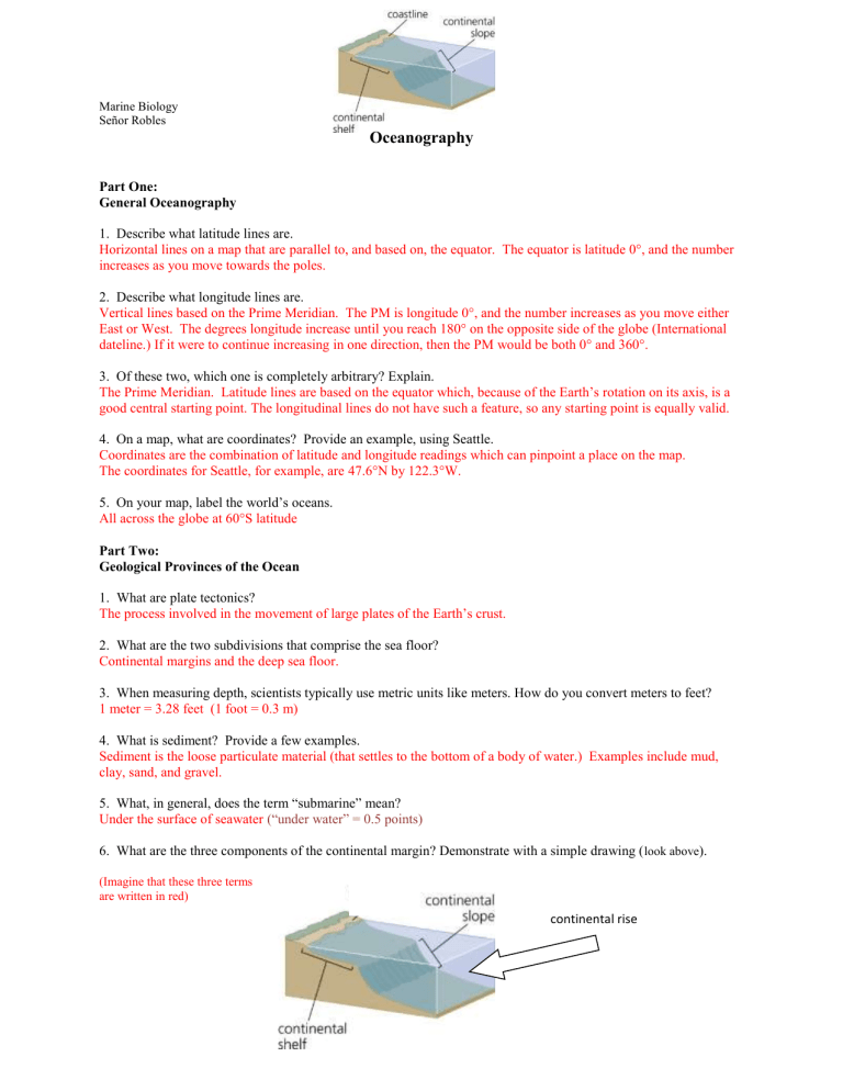
6. What are the three components of the continental margin? Demonstrate with a simple drawing ( look above ).
(Imagine that these three terms are written in red) continental rise
7. What “numerical discrepancy” does the continental shelf provide? (an example of a “numerical discrepancy”
would be the following: the U.S. represents only 5% of the world’s population yet consumes more than 20% of
the world’s energy.) The continental shelf makes up only 8% of the ocean’s surface, but is the biologically
richest part of the ocean (most life and best fisheries.)
8. Explain the mystery of how underwater canyons exist on the continental shelf.
During Ice Ages (when sea levels were low), the continental shelves were exposed and rivers / melting glaciers eroded deep canyons. As sea levels rose, these canyons became submerged.
9. How wide is the continental shelf?
It varies from less than 1km to 750 km (depending on where you are.)
10. What is a deep-sea fan?
An area where sediment moves down a submarine canyon and accumulates at the canyon’s base (like a river delta)
11. Explain how that guyot in the diagram below became flat-topped:
It started out as an island. It begin to subside (because its weight caused it to sink into the lithosphere and/or sea level began to rise), and as it did wave erosion flattened it. Eventually it subsided until it was completely submerged.
Part Three:
Mapping the Sea Floor (based on the exercise Atlantic Ocean Floor Topography Lab)
1. What is topography?
The study of the surface shape and features of the Earth (both dry land and under water.)
2. What geologic feature produces islands in the Atlantic Ocean?
The Mid-Atlantic Ridge
3. Your oceanographic profile should have shown the crust rise until, at 4000 km from N. America, it touched the
surface. What islands does this represent?
The Azores
4. What U.S. state do you think is portrayed on the far left?
New Jersey
5. What European country do you think is portrayed on the far right?
Portugal
6. What technology is used to collect this type of data?
Sonar (same principle as what makes sonograms of unborn babies.)
