Paper Title (use style: paper title)
advertisement

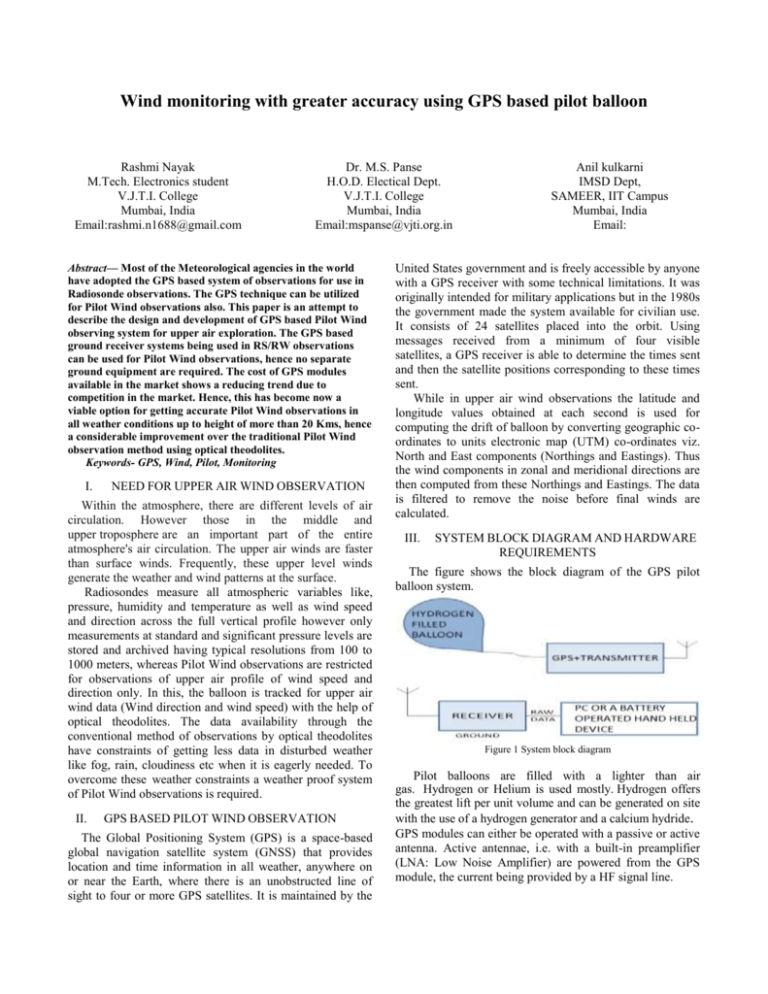
Wind monitoring with greater accuracy using GPS based pilot balloon Rashmi Nayak M.Tech. Electronics student V.J.T.I. College Mumbai, India Email:rashmi.n1688@gmail.com Dr. M.S. Panse H.O.D. Electical Dept. V.J.T.I. College Mumbai, India Email:mspanse@vjti.org.in Abstract— Most of the Meteorological agencies in the world have adopted the GPS based system of observations for use in Radiosonde observations. The GPS technique can be utilized for Pilot Wind observations also. This paper is an attempt to describe the design and development of GPS based Pilot Wind observing system for upper air exploration. The GPS based ground receiver systems being used in RS/RW observations can be used for Pilot Wind observations, hence no separate ground equipment are required. The cost of GPS modules available in the market shows a reducing trend due to competition in the market. Hence, this has become now a viable option for getting accurate Pilot Wind observations in all weather conditions up to height of more than 20 Kms, hence a considerable improvement over the traditional Pilot Wind observation method using optical theodolites. Keywords- GPS, Wind, Pilot, Monitoring I. NEED FOR UPPER AIR WIND OBSERVATION Within the atmosphere, there are different levels of air circulation. However those in the middle and upper troposphere are an important part of the entire atmosphere's air circulation. The upper air winds are faster than surface winds. Frequently, these upper level winds generate the weather and wind patterns at the surface. Radiosondes measure all atmospheric variables like, pressure, humidity and temperature as well as wind speed and direction across the full vertical profile however only measurements at standard and significant pressure levels are stored and archived having typical resolutions from 100 to 1000 meters, whereas Pilot Wind observations are restricted for observations of upper air profile of wind speed and direction only. In this, the balloon is tracked for upper air wind data (Wind direction and wind speed) with the help of optical theodolites. The data availability through the conventional method of observations by optical theodolites have constraints of getting less data in disturbed weather like fog, rain, cloudiness etc when it is eagerly needed. To overcome these weather constraints a weather proof system of Pilot Wind observations is required. II. GPS BASED PILOT WIND OBSERVATION The Global Positioning System (GPS) is a space-based global navigation satellite system (GNSS) that provides location and time information in all weather, anywhere on or near the Earth, where there is an unobstructed line of sight to four or more GPS satellites. It is maintained by the Anil kulkarni IMSD Dept, SAMEER, IIT Campus Mumbai, India Email: United States government and is freely accessible by anyone with a GPS receiver with some technical limitations. It was originally intended for military applications but in the 1980s the government made the system available for civilian use. It consists of 24 satellites placed into the orbit. Using messages received from a minimum of four visible satellites, a GPS receiver is able to determine the times sent and then the satellite positions corresponding to these times sent. While in upper air wind observations the latitude and longitude values obtained at each second is used for computing the drift of balloon by converting geographic coordinates to units electronic map (UTM) co-ordinates viz. North and East components (Northings and Eastings). Thus the wind components in zonal and meridional directions are then computed from these Northings and Eastings. The data is filtered to remove the noise before final winds are calculated. III. SYSTEM BLOCK DIAGRAM AND HARDWARE REQUIREMENTS The figure shows the block diagram of the GPS pilot balloon system. Figure 1 System block diagram Pilot balloons are filled with a lighter than air gas. Hydrogen or Helium is used mostly. Hydrogen offers the greatest lift per unit volume and can be generated on site with the use of a hydrogen generator and a calcium hydride. GPS modules can either be operated with a passive or active antenna. Active antennae, i.e. with a built-in preamplifier (LNA: Low Noise Amplifier) are powered from the GPS module, the current being provided by a HF signal line. The GPS based ground receiver systems being used with radiosonde or rawinsonde system can be used for pilot balloon observations, hence no separate ground equipment are required. There are many different types of brands available in the world market which can be directly used . IV. awaited, the investment is justified. Hence it is feasible to implement the use of pilot-sonde on operational basis in upper air network at Pilot wind observing stations. Initially it may be implemented on trial basis selecting some important stations as per the requirement of individual networks. RESULTS AND CONCLUSION Ten sets of ascents have been compared between conventional pilot balloon using 30 gm balloons and GPS based pilotsonde using 300 gm balloon. References [1] [2] [3] [4] [5] Figure 2 Comparision of conventional vs GPS pilot observations It is evident from GPS based Radiosonde ascent that the flight termination in most of the cases is balloon burst. The GPS receiver does not lose the signal while ascending. The data availability depends mainly on the quality of balloon in all weather conditions. Whereas, the presently used Pilot Wind observations using optical theodolites are heavily dependent on weather conditions. We get more data in clear weather and the data availability decreases with adverse weather when the data requirement increases and we get less data or no data although it is eagerly required by the forecaster. The average height of Pilot Wind observations is of the order of just 4 to 5 km only, mainly because of weather constraints. The use of GPS based system in PB observations is expected to remove all these constraints and average height coverage increased to 20 Kms or more using pilot sonde. The only disadvantage of the system is to provide each of the station; i) A GPS receiver system at each station with PC set up instead of optical theodolite. ii) Daily consumption of GPS Pilot-sonde. The receiver and PC set up are one time investment only (most of the pilot wind observation stations are already equipped with PC) against the provision of optical theodolites, hence no additional financial burden. The additional financial liability is the use of daily GPS based pilot-sonde. For the data availability to a large extent, in most of the cases up to 20 Kms of height, especially in adverse weather conditions, when the data is eagerly O. Nogués-Correig, E. Cardellach Galí, J. Sanz Campderrós, and A. Rius, “A GPS reflections receiver that computes Doppler/delay maps in real time,” IEEE Trans. Geosci. Remote Sens., vol. 45, no. 1, pp. 156–174, Jan. 2007 Sankar.P., Sri Sivasubramaniya Nadar Coll. of Eng., Chennai, India Norman, S.R. “Embedded system for monitoring atmospheric weather conditions using weather balloon” International Conference on Control, Automation, Communication and Energy Conservation, 2009. Page(s): 1 - 4 ,4-6 June 2009. Siegel,H.J.;Maciejewski,A.A.;Oltikar,M.;Brateman,J.;White,J.;Martin ,J.;Knapp,K. “Heuristics for Robust Resource Allocation of Satellite Weather Data Processing on a Heterogeneous Parallel System” IEEE transactions on parallel and distributed systems. Volume: 22 , Issue:11,Page(s): 1780 – 1787, Nov. 2011 Gajendra Kumar, R Madan, K. C. Saikrishnan, S. K. Kunduand P. K. Jain “Technical And Operational Characteristics Of GPS Radiosounding System in the Upper Air Network Of IMD”, Mausam, 62, No.3, July 2011, Pg 403-416. Michael Douglas, John Mejia, Raquel Orozco, “Underutilized observations for studying tropical climate variations: the historicalpilot balloon database” National Severe Storms Laboratory/NOAA, Cooperative Institute for Mesoscale Meteorological Studies, 3Weather Decision Technologies Norman, Oklahoma.


