View /
advertisement
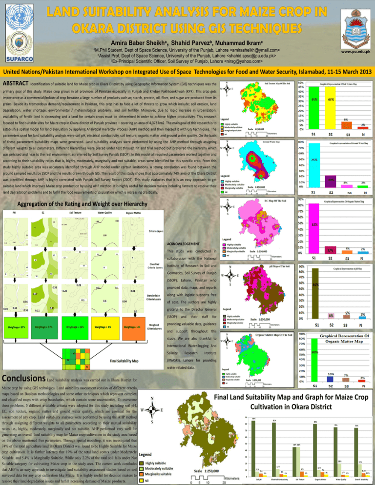
Amira Baber Sheikha, Shahid Parvezb, Muhammad Ikramc aM.Phil Student, Dept of Space Science, University of the Punjab, Lahore <amirasheikh@ymail.com> bAssist Prof, Dept of Space Science, University of the Punjab, Lahore <shahid.spsc@pu.edu.pk> cEx-Principal Scientific Officer, Soil Survey of Punjab, Lahore <nirsg@yahoo.com> www.pu.edu.pk United Nations/Pakistan International Workshop on Integrated Use of Space Technologies for Food and Water Security, Islamabad, 11-15 March 2013 ABSTRACT Identification of suitable land for Maize crop in Okara District by using Geographic Information System (GIS) techniques was the primary goal of this study. Maize crop grows in all provinces of Pakistan especially in Punjab and Khyber Pakhtoonkhwah (KPK). This crop gets importance as a commercial/industrial crop because a large number of products such as; starch, protein, oil, fiber, and sugar are produced from its grains. Beside its tremendous demand/requirement in Pakistan, this crop has to face a lot of threats to grow which include; soil erosion, land degradation, water shortage, environmental / meteorological problems, and soil fertility. Moreover, due to rapid increase in urbanization, availability of fertile land is decreasing and a land for certain crops must be determined in order to achieve higher productivity. This research focused to find suitable sites for Maize crop in Okara district of Punjab province – covering an area of 4,378 km2. The main goal of this research is to establish a spatial model for land evaluation by applying Analytical Hierarchy Process (AHP) method and then merged it with GIS techniques. The parameters used for land suitability analysis were soil pH, electrical conductivity, soil texture, organic matter and ground water quality. On the basis of these parameters suitability maps were generated. Land suitability analyses were performed by using the AHP method through assigning different weights to all parameters. Different Hierarchies were placed under test through hit and trial method but preferred the hierarchy which was précised and near to the real environment as referred by Soil Survey Punjab (SSOP). In this model all required parameters worked together and according to their suitability ratios that is, highly, moderately, marginally and not suitable, areas were identified for this specific crop. From this study highly suitable area was accurately identified through AHP model under certain limitations. A strong correlation was found between the ground sampled results by SSOP and the results drawn through GIS. The result of this study shows that approximately 74% area of the Okara District was identified through AHP, is highly correlated with Punjab Soil Survey Report (2005). This study evaluates that it is an easy approach to get suitable land which improves Maize crop production by using AHP method. It is highly useful for decision makers including farmers to resolve their land degradation problems and to fulfill the food requirements of population which is increasing drastically. Aggregation of the Rating and Weight over Hierarchy ACKNOWLEDGEMENT This study was conducted in collaboration with the National Institute of Research in Soil and Geomatics, Soil Survey of Punjab (SSOP), Lahore, Pakistan who provided data, maps, and reports along with logistic supports free of cost. The authors are highly grateful to the Director General (SSOP) and their staff for providing valuable data, guidance and support throughout this study. We are also thankful to International Water-logging And Salinity Research Institute (IWASRI), Lahore for providing water related data. Conclusions Land suitability analysis was carried out in Okara District for Maize crop by using GIS techniques. Land suitability assessment consists of different criteria maps based on Boolean methodologies and some other techniques which represent complex and classified maps with crisp boundaries, which contain some uncertainties. To overcome these problems, 5 different available criteria were adopted for this study including soil pH, EC, soil texture, organic matter and ground water quality, which are essential for the assessment of any crop. Land suitability analyses were performed by using the AHP method through assigning different weights to all parameters according to their mutual suitability ratios i.e., highly, moderately, marginally and not suitable. AHP performed very well for generating an overall land suitability map for Maize crop cultivation in the study area based on the above mentioned five parameters. Through spatial modeling, it was investigated that 74% of the total agriculture land in Okara District was found to be Highly Suitable for Maize crop cultivation. It is further inferred that 19% of the total land comes under Moderately Suitable, and 5.4% is Marginally Suitable. While only 2.2% of the total soil falls under Not Suitable category for cultivating Maize crop in the study area. The current work concludes that AHP is an easy approach to investigate land suitability assessment studies based on soil surveyed data for any crop cultivation like Maize. It is highly useful for decision makers to resolve their land degradation issues and fulfill increasing demand of Maize products. Final Land Suitability Map and Graph for Maize Crop Cultivation in Okara District
