Lower Levels - Soils @ UGA
advertisement
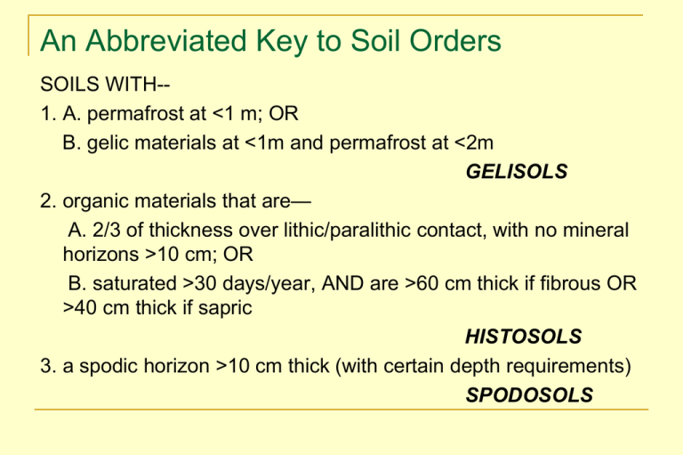
An Abbreviated Key to Soil Orders SOILS WITH-1. A. permafrost at <1 m; OR B. gelic materials at <1m and permafrost at <2m GELISOLS 2. organic materials that are— A. 2/3 of thickness over lithic/paralithic contact, with no mineral horizons >10 cm; OR B. saturated >30 days/year, AND are >60 cm thick if fibrous OR >40 cm thick if sapric HISTOSOLS 3. a spodic horizon >10 cm thick (with certain depth requirements) SPODOSOLS 4. andic soil properties in 60% of the soil within 60 cm of the surface or a lithic/paralithic contact ANDISOLS 5. an oxic horizon within 150 cm of soil surface AND no kandic horizon; OR >40% clay in top 18 cm AND kandic horizon with low weatherable minerals within 1 m of surface OXISOLS 6. a layer >25 cm thick within 1 m of surface with slickensides or wedge-shaped peds, AND >30% clay in all horizons to depth of 50 cm or a lithic/paralithic contact, AND periodic cracking at soil surface VERTISOLS 7. aridic moisture regime AND ochric epidpedon AND one of following within 1 m of surface: cambic, gypsic, calcic, petrocalcic, petrogypsic, natric, OR argillic ARIDISOLS 8. argillic or kandic horizon AND % BS (ECEC) <35% in all horizons 125 below the top of argillic/kandic or to depth 180 below soil surface or to lithic/paralithic contact ULTISOLS 9. mollic epipedon AND %BS (pH 7)>50% in ALL horizons to 180 cm depth or to lithic/paralithic contact MOLLISOLS 10. argillic, kandic, or natric horizon, OR fragipan with clay films in some part ALFISOLS 11. cambic, calcic, gypsic, petrocalcic, OR petrogypsic horizon within 1 m of surface OR oxic or spodic horizon within 2 m of surface, OR sulfuric horizon INCEPTISOLS 12. All other soils ENTISOLS Lower Levels in Soil Taxonomy ORDER SUBORDER GREAT GROUP SUBGROUP FAMILY SERIES FORMATIVE SUFIXES Orders: names of orders end in "sol" alf - Alfisol ept - Inceptisol and - Andisol oll - Mollisol id - Aridisol ox - Oxisol ent - Entisol od - Spodosol el - Gelisol ult - Ultisol ist - Histisol ert - Vertisol Nomenclature of Lower Levels Suborders: names of suborders have two syllables First connotes something about the soil Second is the formative element from the order Udalf - an Alfisol with a udic moisture regime Psamment - (psamm: sandy) an Entisol with a sandy particle size throughout Aquult - an Ultisol with an aquic moisture regime Great Groups: name consists of the suborder and a prefix that suggests something of the diagnostic properties of the soil Paleudalf - (Pale: old); an old (deeply weathered) Udalf Udipsamment - sandy Entisol with a udic moisture regime. Plinthaquult - wet Ultisol with plinthite. Subgroups: name consists of the great group modified by one or more adjectives "Typic" - central concept of the great group Other types of subgroups are: Intergrades toward other great groups Spodic Udipsamment is an intergrade to Spodosols, Extragrades - subgroups not intergrading toward any known kind of soil Lithic Udipsamment is a intergrade to not soil (hard rock within 50 cm of the soil surface) Suborder Criteria Vary WIDELY with particular order --Meant to delineate MAJOR GROUPINGS within each order HISTOSOLS: not saturated: FOLISTS saturated: high fiber content: FIBRISTS low fiber content: SAPRISTS intermediate fiber: HEMISTS For MANY orders, suborder criteria are based on soil moisture regimes as way to separate broad classes within the order Soil Moisture Regimes Determine the potential use of the soil if use depends on water in the soil Suggest processes that have occurred or that are ongoing in the soil The moisture regime, except for the aquic moisture regime, is the result of climate but is based on soil properties: soil moisture content. Dry soil - water content less than that held against 1500 kPa tension Moist soil - water content is greater than that held against 1500 kPa tension but less than saturation. Soil Moisture Regimes: Control Section Upper boundary - depth to which a dry soil will be moistened by 2.5 cm of water within 24 hours. Lower boundary - depth to which a dry soil will be moistened by 7.5 cm of water within 48 hours. These depths are approximately: 10 to 30 cm for loams, silt loams, silts, clay loams, very fine sandy loams, silty clay loams, silty clays, sandy clay loams, sandy clays, and clays; 20 to 60 cm for fine sandy loams and coarser sandy loams; 30 to 90 cm for loamy sands and sands. Moisture Regimes--Overview Aridic: MCS dry >180 d, moist for < 90 d no cropping possible; little soil development Xeric: MCS dry >90 d, moist >180 d; winter rain/dry summer Mediterranean; winter crops; some soil development Ustic: MCS dry >90 d, moist >180 d; summer/uniform rain cotton, irrigated crops; some soil development Udic: MCS dry for < 90 d; typically uniform rain corn cultivation; optimum soil development Perudic: udic, with monthly PPT>monthly ET cooler or very high rainfall Aquic: redox features (<2 chroma) directly below A Aridic Moisture Regime Blaine County, Montana Soil water holding capacity = 22 cm 16 Precipitation ET Precipitation or ET, cm 12 Deficit 8 4 Utilization Recharge 0 Sep Nov Jan Mar May Jul Sep Udic Moisture Regime Tallulah, Louisanna Soil water holding capacity = 22 cm 20 Precipitation Evaptranspiration Precipitation or ET, cm 16 Utilization 12 Deficit 8 Surplus (leaching) Recharge 4 0 Sep Nov Jan Mar May Jul Sep Ustic Moisture Regime Lynn County, Texas Soil available water capacity = 22 cm Annual Precipitation = 65 cm 16 Precipitation ET 12 Precipitation or ET, cm Deficit Utilization 8 4 Recharge 0 Sep Nov Jan Mar May Jul Sep Ustic Moisture Regime Lagos, Nigeria Soil water holding capacity = 22 cm 40 Precipitation ET Precipitation or ET, cm 30 Recharge 20 Utilization 10 Deficit 0 Sep Nov Jan Mar May Jul Sep Xeric Moisture Regime Solano County, California Soil available water capacity = 22 cm Annual Pecipitation = 68 cm 16 Precipitation or ET, cm 12 8 Recharge Surplus Deficit Utilization 4 Precipitation ET 0 Sep Nov Jan Mar May Jul Sep Aquic Moisture Regime Soils with an aquic moisture regime have aquic conditions immediately below an ochric epipedon or albic horizon Aquic conditions: Horizons with aquic conditions are those that experience continuous or periodic saturation and reduction Presence of aquic conditions is indicated by redoximorphic features and is verified by measurement of saturation and reduction in the field. Aquic Moisture Regime - Saturation Saturation - zero or positive pressure in the soil water. This can be determined be observing "free water" in an unlined auger hole. Duration of saturation is not specified. Three types of saturation are recognized: Endosaturation – saturated in all horizons from the upper boundary of saturation to 2 m or more. Episaturation – saturated in one or more horizons above horizons within 2 m that are not saturated (perched water table). Anthric saturation - variant of episaturation associated with controlled flooding for wetland rice. Produces reduction in the saturated surface soil and oxidation of reduced Fe and Mn in the oxidized subsoil. Suborder Example: Ultisols Ultisols that have— 1. Aquic conditions: redox features (including depletions) directly below the epipedon. AQUULTS 2. >0.9% organic carbon in the upper 15 cm of the argillic/kandic HUMULTS 3. A udic moisture regime UDULTS 4. A ustic moisture regime USTULT 5. Other ultisols (presumably, xeric moisture regime) XERULTS Some other suborder designations… Temperature regimes: cryalf, torrand, geland Soil moisture regimes: udalf, xeralf, ustalf, perox; aq- (wet): aqoll, aqod Specific soil properties/horizons: vitrand turbel humult durid, cambid, salid, gypsid, argid, calcid hemist, folist, fibrist, saprist rendoll, alboll arent, psamment, fluvent, orthent Great Group Example: Udults… Have a subsurface horizon with >50% (vol) plinthite: Plinthudults Have a fragipan within 1 m of surface: Fragiudults Have a kandic horizon, and do not have a clay decrease of >20% (relative) within 150 cm of surface: Kanidudults Have a kandic horizon (with clay decrease) Kanhapludults (Have an argillic horizon and) do not have a clay decrease of >20% (relative) within 150 cm of surface: Paleudults Have an epipedon with value of 3 or less throughout, AND in the upper 1 m of the argillic horizon, at least 50% of the volume has color hues of 2.5YR or redder and values of 3 or less: Rhodudults All other Udults: Hapludults Subgroup Examples (for Hapludults) Lithic contact at <50cm Lithic Surface cracks and slickensides in subsurface Vertic <2 chroma depletions in upper 60 cm of argillic Aquic Fragic properties in 30% of subsurface layer >15 cm thick Fragic Sandy particle size in upper 75 cm of argillic Psammentic Sandy particle size from surface to top of argillic at depth of 50-100 cm Arenic Sandy particle size from surface to top of argillic at depth of >100 cm Grossarenic ….. (6 other ones: total of 14) OTHER Hapludults Typic Family Criteria Soil families serve purposes that are largely pragmatic and to enhance interpretation ability Family names include and are listed as part of the classification in the following order: Particle-size class Mineralogy class Cation-exchange activity class* Calcareous and reaction class * Soil temperature class Soil depth class * Soil rupture resistance or consistence class * Class of coatings (on sands) * Class of cracks * “Fine, kaolinitic, thermic” “Loamy-skeletal, mixed, mesic” Key to Particle Size Control Section: A. For mineral soils that have a root-limiting layer within 36 cm of the mineral soil surface: From the mineral soil to the root-limiting layer; or B. For those Alfisols, Ultisols, and great groups of Aridisols and Mollisols that have an argillic, kandic, or natric horizon that has its upper boundary within 100 cm of the mineral soil surface and its lower boundary at a depth of 25 cm or more below the mineral soil surface or that are in a Grossarenic or Arenic subgroup: Either the entire argillic, kandic, or natric horizon if 50 cm or less thick, or the upper 50 cm of the horizon if more than 50 cm thick; or C. For those Alfisols, Ultisols, and great groups of Aridisols and Mollisols have an argillic, kandic, or natric horizon that has its upper boundary at a depth of 100 cm or more from the mineral surface and that are not in a Grossarenic or Arenic subgroup: Between 25 cm from the mineral soil surface and 100 cm below the mineral soil surface or a root-limiting layer, whichever is shallower; or D. For other soils that have an argillic or natric horizon that has its lower boundary at a depth of less than 25 cm from the mineral soil surface: Between the upper boundary of the argillic or natric horizon and a depth of 100 cm below the mineral soil surface or a root-limiting layer, whichever is shallower; or E. All other mineral soils: Between 25 cm below the mineral soil surface and either 100 cm below the mineral soil surface or a root limiting layer, whichever is shallower. Family Particle-Size Classes 100 90 10 80 20 very fine 70 30 50 t Sil % 40 % Cl ay 60 50 fine 40 60 30 fine silty fine loamy 20 70 80 10 coarse silty coarse loamy 90 sandy 100 90 80 70 60 50 % Sand 40 30 20 10 100 PARTICLE SIZE FAMILIES For soils that are <50 cm to root-limiting layer, or are in a Lithic, Arenic, or Grossarenic subgroup: <35% clay in control section: “loamy” ≥35% clay in control section: “clayey” Soils that are >50 cm to a root-limiting layer use the following family names: 35-60% clay in control section: “fine” >60% clay in control section: “very fine” NOTE clay % for “textural classes” do NOT correspond exactly to this triangle…. Control sections that have >35% fragments use the following family names: --sand or loamy sand textures: “sandy-skeletal” --<35% clay: “loamy-skeletal” --≥35% clay: “clayey-skeletal” Family particle size name is NOT used with “psamments” (“sandy” family is implied) NOTE: “Lithic” families have lithic contact at <50 cm; “Arenic” families have 50-100 cm of sandy particle size class at surface (A+E); “Grossarenic” have >100 cm sand at surface. Particle-Size Class The particle-size class is determined from the weighted average particle size within the control section. The weighted average is calculated by: SUM(% fraction horizon X thickness of horizon) / control section thickness Particle-Size Control Section Horizon Ap E1 E2 BE Bt1 Bt2 Depth, cm 0-15 15-33 33-47 47-62 62-88 88-132 Sand, Clay, % % 68 12 72 13 74 11 45 25 48 39 53 32 Weighted average clay = [(15 X 25) + (26 X 39) + (9 X 32)] / 50 = 33.5 Weighted average sand = [(15 X 45) + (26 X 48) + (9 X 53)] / 50 = 48.0 Family particle-size class is fine-loamy Particle-Size Classes Three generalized particle-size classes clayey - >35% clay loamy - <35% clay sandy – weighted average particle size is sand or loamy sand used for soils in shallow families and for soils in arenic, grossarenic, lithic, and pergelic subgroups Other soils (fall-out key in Soil Taxonomy) Fragmental - <10% fine earth material (<2mm); >90% coarse fragments Sandy-skeletal - sand or loamy sand texture and 35-90% coarse fragments Loamy-skeletal - <35% clay and 35-90% coarse fragments Clayey-skeletal - >35% clay and 35-90% coarse fragments Particle-Size Classes There are two situations in which particle-size class names are not used. The name is redundant, e.g. Psamments The soil is such that particle-size analysis is difficult to apply and particle-size does not adequately describe particle characteristics For anisols: terms used to replace particle-size classes include ashy, pumiceous, medial, hydrous, and others. Strongly contrasting particle-size classes: If the particle size changes significantly within the control section and the transition is less than 12.5 cm, terms are used to describe the strongly contrasting particle size classes, e.g. clayey over loamy. Soils with andic properties Mineralogy Classes Control section is the same as that for particle size. Mineralogy placement is dependent on particle-size class which determines the fraction of the soil used to determine mineralogy For many soils, the mineralogy class is determined either for the whole soil (<2 mm) or for the sand and silt fractions Clay mineralogy specified only for Oxisols Kandi and Kanhap great groups Soils with fine, very-fine, clayey, or clayey-skeletal particle-size class Mineralogy class is determined from the key for mineralogy classes Common Mineralogy Classes for SE Soils Sandy or loamy particle-size class Mineralogy of coarse silt and sand (0.02-2 mm) Siliceous – >90% quartz and other resistant minerals Mixed – other soils Fine or very-fine particle size class and kandi or kanhap great groups Mineralogy of clay separate (<0.002 mm) Kaolinitic – >50% kaolinite and <10% smectite Smectitic – more smectite than any other clay mineral Mixed – other soils Cation-Exchange Activity Classes Intended to help interpret mineralogy and nutrient retention capacity of soils in mixed and siliceous mineralogy classes Not used in Histosols, Oxisols, kandi and kanhap great groups, or in soils with sandy or sandy-skeletal particle size classes Control section same as particle-size and mineralogy Based on CEC (pH 7.0) to clay ratio superactive - >0.60; smectite and other reactive clays active - 0.40 to 0.60 semiactive - 0.24 to 0.40 subactive - <0.24; kaolinite and other low-activity clays Calcareous and Reaction Classes Only used for selected taxa Control section - 25 to 50 cm Classes allic – high extractable Al calcareous - effervesces with HCl in all of control section acid - pH <5.0 in 0.01 M CaCl2 (about 5.5 in water) throughout the control section. non-acid - pH >5.0 in 0.01 M CaCl2 in some or all of the control section - not used in family name of calcareous soils. Soil Temperature Classes Mean annual soil temperature estimated by adding 1o C to mean annual air temperature. Classes of soil temperature: Pergelic - mean annual soil temperature <0o C Cryic - mean annual soil temperature between 0 and 8o C and mean summer soil temperature is <15o Frigid - mean annual soil temperature between 0 and 8o C (mean summer temperature >15o C is implied) Mesic - mean annual soil temperature between 8 and 15o C Cotton and yellow pine Hyperthermic - mean annual soil temperature is 22o C or higher Corn and winter wheat Thermic - mean annual soil temperature between 15 and 22 o C Permafrost at a shallow depth. Citrus For frigid, mesic, thermic, and hyperthermic temperature regimes; an iso prefix is used if the mean summer and mean winter soil temperature differ by less than 6o C, i.e. isofrigid, isomesic, isothermic, and isohyperthermic. Designates tropical climates Other Family Groupings Used to provide reasonable groupings of certain series Many of the characteristics are poorly understood Depth of soil “shallow” - less than 50 cm (100 cm in Oxisols) to upper boundary of rock or root limiting horizon and not in lithic subgroup Rupture Resistance “ortstein” and “noncemented” - used only for Spodosols. Classes of coatings - only used for Psamments “coated” - silt + (2 X clay) > 5 “Uncoated” - silt + (2 X clay) < 5 Classes of permanent cracks “Cracked” is the only class Used only in Fluvaquents and Humaquepts Series Lowest category in Soil Taxonomy Purpose is mainly pragmatic More than 19,000 series in the United States Closely related to interpretations Differentiae used for series are the same as those used for classes in other categories Series properties cannot range across limits of classes in higher categories Cecil must be a fine, kaolinitic, thermic Typic Kanhapludult Rion must be a fine-loamy, siliceous, themic Typic Kanhapludult Cataula must be a fine, kaolinitic, themic Oxyaquic Kanhapludult Many families only have one series Greater Restriction within a Family Fine, kaolinitic, thermic Typic Kanhapludults fine-loamy, siliceous, thermic Plinthic Kandiudults Cecil – Bt horizon has hue of 2.5YR or redder Appling – Bt horizon has hue of 5YR or yellower Tifton – common Fe stone in upper Bt Dothan – no Fe stone in upper Bt Distinctions within a family are restrictions in the range of one or more properties of the family Only those differences that serve to distinguish one series from another are included in statements of series differences 3 Tests of Series Differentiae Properties serving as differentiae can be observed or can be inferred with reasonable assurance Differentiae must create soil series having a unique range of properties Difference among series should be greater than normal errors made by qualified pedologists Differentiae must reflect a property of the soils Can be reflected in the nature or degree of expression of one or more horizons. May also be Can be almost any horizon or soil property Landscape property Commonly associated soils Climate We may not be as smart as we think Phase Properties that may influence certain but not all uses of a soil Slope Stoniness Aspect “Wind swept” Not a part of Soil Taxonomy Utilitarian classification that can be superimposed at any categorical level to permit more precise interpretations for soil use Competing Series Statement - Cecil These are the Appling, Bethlehem, Madison, Nankin, Pacolet, Tumbleton, and Wedowee series in the same family Those in closely related families are the Aragon, Braddock, Cataula, Chestatee, Cullen, Georgeville, Hayesville, Herndon, Hulett, Kolomoki, Lloyd, Mayodan, Mecklenburg, Spotsylvania, Tatum and Wedowee series Appling soils have dominant hue of 7.5YR or yellower or where hue is 5YR it has evident patterns of mottling in a subhorizon of the Bt or BC horizon Aragon soils contain fragments of chert, and have a cherty limestone C horizon. Bethlehem soils are moderately deep to weathered bedrock of sillimanite schist, phyllite schist, or mica schist. Braddock and Hayesville soils are mesic Cataula soils have a fragipan, Chestatee soils contain more than 15 percent, by volume, of coarse fragments throughout the pedon . . . . . . . Piedmont Series Key Upper 50 cm of Bt horizon has >35% clay Bt horizon has hue of 5YR or redder Upper part of Bt horizon has common mica flakes - Madison Bottom of Bt horizon with more than 35% clay is 45 to 75 cm below the surface – Pacolet Bottom of Bt horizon with more than 35% clay is more than 75 cm below the surface – Cecil
